Our earlier visit to Snowdonia
Lolli had visited me in the UK in August 2008, and we had travelled to Snowdonia, Wales to meet up with dadndave and his lovely family for a couple of great days.
On one of those days, Lolli, dadndave and myself had walked up Snowdon, at 3,560 feet, the highest mountain in Wales. Well we are all SP’ers and we felt we should do something appropriate to that fine Organisation!
It may have been August and mid summer in Wales, but Snowdon showed us that despite it’s relatively small size it can produce it’s own brand of weather: heavy rain, low visibility and winds gusting to 75 mph! Oh well, better luck next time.
We head back to Snowdonia
I had said goodbye to Lolli and dadndave and family at Stansted at the end of that August 2008 trip. More of an “au revoir” really as Lolli was keen to come back and walk the Snowdonian mountains with me again. So, early in April 2009 Lolli did indeed return and after meeting at Heathrow Airport we headed off to Beddgelert.
A lovely village where I had found the Bistro was a superb place to base myself for what had become frequent visits to the area.
The Bistro has just three rooms for B&B, and they were all full for our planned four night stay. But they had booked us into a small stone cottage just up the road: and ideal place to base ourselves for three days of hard walking. Being close to the Bistro also meant we would breakfast there, (full cooked English style every morning!), and enjoy their lovely evening meals.
April 3rd: Y Lliwedd via the Watkin Path.
A day that was to be characterised by a cloud base that never really cleared totally above about 2,500 feet, despite a forecast that it would! But that was not really in our minds as we parked at Nantgwynant, a tiny hamlet South East of Snowdon and about 4 miles from Beddgelert on the A498 road, and headed out onto Snowdon’s Watkin Path.
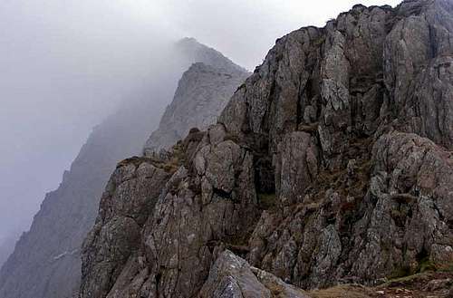
But Snowdon was not our goal for the day! We were heading for Y Lliwedd a mountain adjacent to Snowdon but with perhaps a far more colourful history. It was on the near vertical rock cliffs that form Y Lliwedd’s North face that George Mallory of Everest fame did a lot of his early climbing. And it was also where Sir Edmund Hillary and part of his team for the 1953 Everest Expedition did some of their preparation.
Right is a great photo of Y Lliwedd taken by Nanuls from Snowdon, in much better weather than Lolli and I enjoyed!
Our aspirations for the day were not at that level! We just wanted to go up the Watkin path to Bwlch Ciliau, where the Snowdon route turned NE , and where we would start a straightforward scramble SE to the West Peak of Y Lliwedd: it’s highest summit at 2,945 feet.
Our path headed up a valley on a very straightforward and gently rising track through Cwm Llan, next to the fast flowing Afon, (river), Cwm Llan. Past the Gladstone Rock where UK Prime Minister William Gladstone stood, (at the age of 82), and delivered a speech on Justice for Wales on the day the Watkin path was formerly opened.
For us it was just easy walking, and I knew that Lolli wanted more than that! So I was happy, (Lolli even more so), when we got to the start of the rockier section just below Bwlch Ciliau, from where we would need to get our hands on the rocks.
We paused at the Bwlch, now under a patchy cloud base and were just able to catch a glimpse of the lake, Llyn Llydaw, some way below us.
As the cloud momentarily lifted, were able to see the bulk of Y Lliwedd towering above us. Scaring us both by the severity of it’s North Face Cliffs, and making certain we would find a scramble route up on the more Southerly, (right hand), slopes!
There were traces of various paths in amongst the scrambly bits, but nothing distinct enough to follow. That was what I had expected to find.
I got a sight of the summit way above us as the cloud base was blown away for few moments and decided on a straight line approach.
“The Benn Route” as Lolli named it!
Easy grade 1 scrambling on secure rock with plenty of terraces to walk across on the way up. Just the sort of terrian I enjoy: not too hard for me, and nothing much to trigger my vertigo!
After our long approach walk we both enjoyed this section: very obvious from the smile that appeared on Lolli’s face.
I was enjoying myself scrambling up the direct route to the summit!
All too soon we were on the top, and mainly in the cloud base, so we basically looked out over nothing!
“Right, we’re going down the Lolli route”, said my walking companion. And she is not someone to be argued with! So a sort of straight line was aimed for down a very steep, slithery, scrambly rock and scree slope that headed for the Watkin Path, (when we could see it in the low cloud). We got onto the path and looked back up at the “Lolli Route” down. “Oops, that looks steep, not a route I’d ever think of going up!”. Well maybe not, as we retraced our steps on the steady and straightforward path, perhaps with some regret that the exciting sections for the day were behind us.
April 4th: Mynydd Sygyn and the Aberglaslyn Pass
I’d planned a half day walk for day two of our three day trip, sandwiched in between two longer days in the mountains. Well, that is what you do as the years go by! A sort of half rest day. And Lolli was fine by me doing that.
This was an afternoon walk starting from Beddgelert village itself. One I often do as a “warm up” when I arrive for a longer trip. I've even done it in the pitch dark with a headtorch, (Christmas morning last year). That was in frosty and icy weather: not repeated today as it was partly cloudy and mild.
It starts by passing through a gate between some cottages right in the center of the pretty village. And straight up a steep, rocky and at times scrambly track to the modest hill summit of Mynydd Sygyn, (just under 1,000 ft).
A small hill with views sometimes far above it’s station in life. And not bad today, despite variable visibility.
I led the way up, so could turn quite often to see the top of Lolli’s hat below me as she tackled the frequent steep sections.
Being a gentleman, (well I do try to be one sometimes), I let her overtake me so she could be first to stand on the modest summit rock area. Well that’s my story and I’m sticking to it!
The weather now decided to allow us to enjoy some of the views. The best being that to the West, with the whole of Beddgelert laid out below us, with the outline of the Nantlle Ridge on the skyline some miles away.
If using the walk as a warm up I would have headed NE over the 1,000 foot high plateau, before descending to the old Sygyn Copper Mine and quickly back to Beddgelert. But today we lengthened the walk by wandering over the undulating terrain until we found the main trail down from Bwlch-y-Sygyn. That took us to the valley floor past an old stone cottage literally built into the hillside. All of the rear part of the cottage is below ground level!
From there it was a short distance into the Aberglaslyn Pass and the quite rocky track that heads along it. The rivers here feed off the local mountains, and for once there had not been days of torrential rain, so the flow though the Pass was modest. Which ensured we both stayed dry, but meant we missed the excitement provided when the rain filled river rages through in great surging torrents. Exiting the Pass took us into wide open meadowland, and back to our starting point, and cottage, in the village.
April 5th: Carneddau circular around Cwm Eigiau.
This was our longest walk with the most vertical ascent of the three days of our trip. Circa 4,000 feet of ascent, and taking into account a number of diversions I reckon we walked close to 15 miles. I’d planned to do it on Day 1, (April 3rd), but had held it back in the hope of getting some good clear weather, as the area we would walk through really deserved that.
That patience was to be rewarded as we drove along the narrow, gated track into Cwm Eigiau and parked at over 1130 ft up. I hadn’t done this full walk in the Carneddau region of Snowdonia before, but had been here and researched it in part. So it was nice to sit in the car and have the farm gates opened and shut for me! Thank you Lolli.
It was the last of those gates that Lolli opened onto what for me is one of the best views in the whole of Snowdonia. Cwm Eigiau with the backdrop of two of the mountains that would form the last of five summits we would attain that day in front, and with our first summit just to one side. It is also a very quiet place to walk from, truly far from the madding crowds that other parts of Snowdonia can become. And a walk that was to stay that way most of the way round. The Carneddau is a comparatively large area, without too much road access, leaving plenty of room for those who walk there.
We started in superbly clear weather and on easy grass slopes, changing briefly as we reached the rocky outcrop of rock that forms the summit of Graig Eigiau.
From where we could see the entire circular walk, including the scrambles down to and along the Bwlch Eryl Farchog Ridge that connected Penywaun wen and Pen yr Helgi Du, two more summits for us to reach.
But first we had to get up to the top of Carnedd Llewelyn, at 3489 ft, the highest mountain in the Carneddau. That was mainly a slog over grassy slopes, with a final rocky section. As we got in sight of the summit some cloud built up, and the base lowered below us. Hmmmmm…. Do we go on with the walk, (navigation for the last bit would be hard work in low visibility), or go back the way we had come. The look on Lolli’s face decided me to continue for a while at least: she hadn’t walked all those grassy slopes to be denied the rocky, scrambly bits!
And that was a good decision, as the cloud was a temporary aberration, with crisp and clear weather soon to return and stay with us.
A short stop on the summit of Carnedd Llewelyn allowed us to briefly view our route ahead, the most interesting and exciting section of the walk. Starting with a steep and rocky descent towards Penywaun wen.
Penywaun wen is a small summit not on many lists. But it has a name and a height and is on the Ordnance Survey maps, so for me it counts as a summit! Number three for today. It also stands guard over a steep slably scramble down onto the Bwlch Eryl Farchog Ridge which leads onto Pen yr Helgi Du, (photo above), as well as overlooking the steep rocky cliffs of Craig yr Ysfa: a true climbing area.
The scramble down was interesting, but was one I had done before. So I knew where to slide!
We stopped briefly before the ridge to enjoy the view over Fynnon Lugwy Reservoir. From the side of which there is another route up onto the ridge: a steep rocky path that I had been down once in conditions where you could hardly see more than few feet in front. Today, thankfully, the weather was much better.
After our brief stop we were onto the fairly narrow ridge heading towards our next summit, that of Pen yr Helgi Du.
Lolli was hungry, we’d been going for some hours, but I wanted to get up the steep and in places exposed scramble to the top of Pen yr Helgi Du first, (photo above).
I didn’t like the look of the exposure on the North side, (I do suffer quite badly from vertigo at times), so found a "route" up the South side of what was close to being a tower, where the drop off wasn’t so bad.
That meant we ignored what I think was an easier route. So being on our own route meant some squeezing past rocks on narrow ledges. And one point I had to crawl along a small ledge under an overhanging rock and nearly got stuck with my rucksac jammed up against it!
From the shouts coming up from below me as I scrambled on up, I think Lolli followed my route exactly! Sorry.
Photo right: Lolli gets back onto the more normal route up Pen yr Helgi Du, but not very far from the summit!
With the great Cliffs of Craig yr Ysfa behind her, Lolli takes the last few steps onto the summit of Pen yr Helgi Du. And yes, it was fun, and we were both very pleased to have done that ascent.
We celebrated that scramble with a light lunch in cool but sunny conditions. Taking time to enjoy the maginficent view to the SW over Ffynnon Llugwy Reservoir and beyond to the Glyders and more of Snowdonia.
Leaving the summit and despite lots of sunshine Lolli decided to wrap up even more against a fairly chilly wind that was blowing, (photo left).
We now had a descent over a steep and mainly grassy slope before we would have to make our final ascent of the day to Pen Llithrig y Wrach, “The Slippery Peak of The Witch”, and no, I didn’t dare make any jokes about that, I’m not that brave. The drop off East to the massive Lyn Cowlyd Reservoir was far too steep!
The very large Lyn Cowlyd Reservoir viewed from the top of Pen Llithrig y Wrach
Above: A look back at the route we had followed from the top of Carnedd Llewelyn, (background with streaks of snow), over the two scrambles at either end of the Bwlch Eryl Farchog Ridge, (only a very small part visible), and then the summit of Pen yr Helgi Du. In my view one of the best hill walking sections in Snowdonia.
[img:573097:alignright:medium:]
We didn’t stay long, soon heading off down steep and mainly grassy slopes towards an old mining spoil heap. There wasn’t a trail so we found our own way. Me by chasing the odd sheep, and Lolli by sliding down bits on her backside!
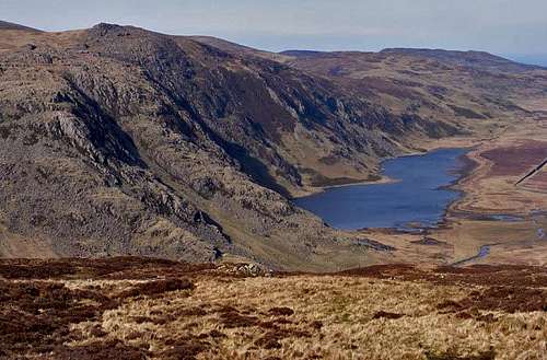
Eventually back in the valley, Cwm Eigiau,(photo right), it was just a long slog along the entire length of the Llyn Eigiau Reservoir, and then further back to where we’d parked some nine and a half hours earlier. A great walk in near perfect conditions. A superb way to end a great long weekend of walking with Lolli.
Oh. That wasn’t really the end of the trip. We went back to Beddgelert for a lovely evening meal, our last night in the stone cottage, and of course I drove Lolli back to a chaotic Heathrow Airport the next day. Calling into historic Warwick on the way for very pleasant pub lunch.
Thank you Lolli. You were great company for that lovely trip to the Snowdonian Mountains.
Comments
No comments posted yet.