
|
|
Mountain/Rock |
|---|---|
|
|
43.15270°N / 122.066°W |
|
|
Hiking, Mountaineering, Trad Climbing, Scrambling |
|
|
Spring, Summer, Fall, Winter |
|
|
9182 ft / 2799 m |
|
|
Overview
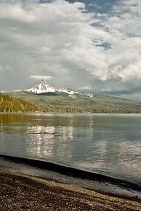
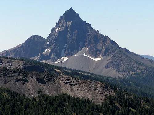
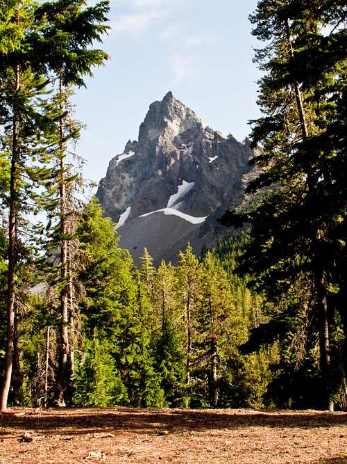
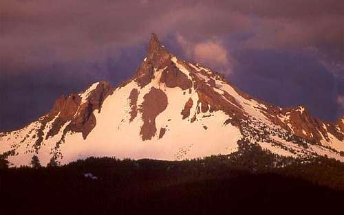 Thielsen from the west
Mount Thielsen is a dramatic horn-shaped peak located in the Southern Oregon Cascades just north of Crater Lake. The peak rises abruptly from its surroundings to a very distinct spire. Its north and east faces are most impressive, towering 2200 feet upward in a near vertical fashion. Due to its dramatic spire shape, its dominance among other peaks in the region and the unstable weather this region receives Mount Thielsen is said to be struck by lightning more often than any other High Cascade peak, earning it the nickname the lightning rod of the Cascades.
This is the reigning peak in this part of the Cascades, there is no summit in the range higher until you reach the South Sister to the north and Mount McLoughlin to the south. Situated on the east side of Diamond Lake, it is directly opposite Mount Bailey, which offers sno-cat skiing and snowboarding in the winter. It is just south of Howlock Mountain, another rugged peak that is the third highest summit in the Diamond Lake area.
Despite its intimidating appearance, a climb of Mount Thielsen is a relatively straightforward undertaking. The West Ridge is an exhilarating route, not quite technical but with enough exposure to get the adrenaline pumping. The true summit is a spectacular spire sticking impressively upward into the sky. Standing on the summit, the land seems to drop off thousands of feet in almost every direction, giving the same feeling as if hovering high above the dense forests of the Oregon Cascades. Views are expansive in every direction, on a clear day Mount Shasta is visible to the south and the Three sisters are visible to the north. The summit of Mount Thielsen is also the only place outside of Crater lake National Park where the waters of Crater Lake are visible.
 Thielsen from the southeast Thielsen from the southeast |
 North Face North Face |
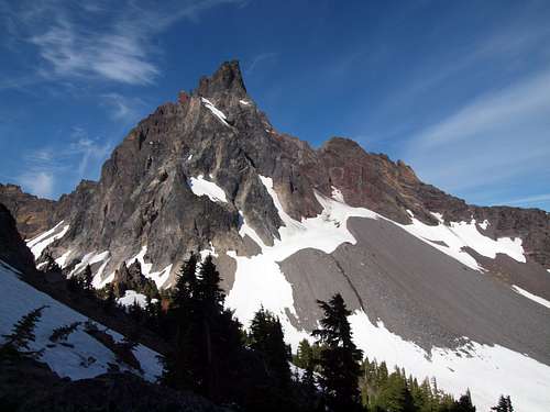
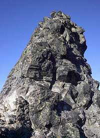
 The Summit Spire The Summit Spire |
 Thielsen from the west Thielsen from the west |
Geology:
Mount Thielsen is the eroded remnant of a shield volcano. Having gone extinct 290,000 years ago, multiple episodes of glaciation have stripped much of the rock from the mountain's lower reaches. Erosion has wiped out any trace of a summit crater. The mountain's jagged spire is all that remains of the volcano's central plug. The plug is composed of basaltic andesite, while the lower slopes are composed of pumice and volcanic breccia.
The forests on the mountain's lower slopes are typical of drier climates, despite the region's moist climate. This is due to the porous nature of the volcanic ash in the soils. Much of the rock present on the mountain today is volcanic ash from the cataclysmic eruption of Mount Mazama. This ash layer ranges from 12 to 60 feet deep, thick enough to deprive the region's trees of significant water.
Thielsen's summit pinnacle is home to numerous lightning caused scars called fulgurites. These scars consist of small specs of obsidian-like glass on the summit rocks. Some of the more defined fulgurites appear as glass tubes that splinter and branch outward.
Mount Thielsen is also home to Oregon's southernmost glacier, the Lathrop glacier. It occupies a small cirque at the base of the mountain's massive north face, an area that sees little sunlight.
More information about the mountain's geology can be found at this link.
 Lathrop Glacier Lathrop Glacier |
 Storm rolling in Storm rolling in |
 From Diamond Lake From Diamond Lake |
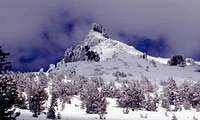 Thielsen in Winter Thielsen in Winter |
 Thielsen's east face
History:
Originally Mount Thielsen was informally named Big Cowhorn. It was one of two “cowhorn” peaks in the area along with Little Cowhorn, both peaks were capped with dramatic spires that resembled the horns of a cow. Later on the names faded away. In 1872 the peak was officially named Mount Thielsen by John A. Hulburt of Portland in honor of Hans Thielsen, a prominent railroad engineer and builder. In 1911 a storm blew the pinnacle off Little Cowhorn, and today Little Cowhorn is known as Cowhorn Mountain.
The first recorded ascent of Mount Thielsen was done by Ensign E Hayden in 1883. Hayden was a member of a USGS team studying the mountains of the Cascade Range.
In 1968 a daring first ascent of the peaks northeast ridge was performed by Tom and Bob Bauman and Gary Kirk. The route was named the McLaughlin Memorial route after Mark McLaughlin, a friend of theirs who died on Denali.
Getting There
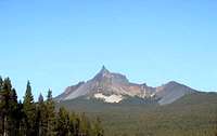
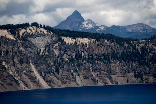 Mount Thielsen from Crater Lake
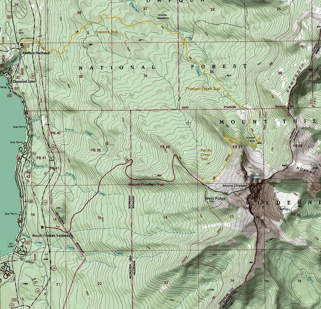
From Medford: Head north on Highway 62 for 56 miles to the junction with Highway 230. Continue for 24 miles on 230 to to Highway 138. Head north on Highway 138 in the direction of Diamond Lake for 1.4 miles to the signed Mount Thielsen trailhead. If you wish to approach from the Thielsen Creek Drainage, continue another 3 miles to the Diamond Lake Loop Road. Head .3 miles south and turn on corral road to reach the trailhead.
From Roseburg: Head east on Highway 138 for 79 miles to the signed Mount Thielsen trailhead. If you wish to approach from the Thielsen Creek Drainage, turn 3 miles earlier on the Diamond Lake Loop road. Head .3 miles south and turn on corral road to reach the trailhead.
From Bend: Head south on Highway 97 for 75 miles to the junction with Highway 138. Head east on Highway 138 for 21 miles to the Diamond Lake Junction. From here head north on Highway 138 in the direction of Diamond Lake for 1.4 miles to the signed Mount Thielsen trailhead. If you wish to approach from the Thielsen Creek Drainage, continue another 3 miles to the Diamond Lake Loop Road. Head .3 miles south and turn on corral road to reach the trailhead.
Approaches
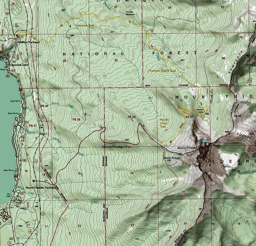
Most people climb Mount Thielsen by the standard Mount Thielsen Trail. This option is best for a short, straightforward day trip. In addition to the standard approach I've chosen to document a longer, but highly scenic approach through the Thielsen Creek drainage. Both of these approaches are shown on the map bellow. Both options involve roughly 3800 feet of elevation gain. (Note: both approaches listed here are for the standard West Ridge route.) If climbing Thielsen as part of a longer backpacking trip there are numerous other approaches, too many to list here. The Northern reaches of the Mount Thielsen Wilderness are highly scenic and worthy of a visit.
 Thielsen West Ridge
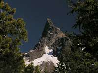 Thielsen Summit Spire
Mount Thielsen Trail: 4 miles to the junction with the PCT and the start of the West Ridge route. 5 miles to the summit.
As the name implies, this is the standard approach for Mount Thielsen. The trail begins at the Mount Thielsen Trailhead, and gradually climbs to the junction with the PCT, and the start of the use trail up the West Ridge. A section of the trail was recently re-routed to bypass a massive blow-down. No water is available.
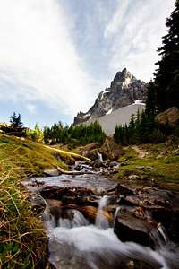
 Thielsen Creek Meadows
 Northern Slopes of Thielsen
Thielsen Creek Trail: 7.5 miles to the start of the west ridge route. 8.5 miles to the summit.
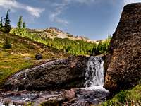
While longer than the Mount Thielsen Trail, this approach is in many ways superior. The scenery is superb and water sources are more plentiful. In addition, Thielsen Creek Meadows offers fantastic camping beneath the 2700 foot north face of this great peak. The approach follows the Howlock Trail to the Thielsen Creek trail, then follows the Thielsen Creek trail to the junction with the PCT, and then follows the PCT to the base of the west ridge. This is a great option for those wanting to do an overnight trip.
 |
Routes
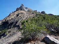
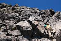
West Ridge (Standard Route): This route begins as a use trail up the scree and talus of the lower mountain, later becoming a class 3 scramble as the ridge steepens. The final climb up the summit pinnacle is a class 4 scramble on the only solid piece of rock on the mountain.
McLaughlin Memorial Route: A seldom done route that follows the NNE ridge of the peak. The rock quality is reportedly very poor, and the route features “an unprotectable 40 foot vertical cinder pitch”. An interesting discussion of this route, including commentary from the first ascensionist, can be found here. A detailed route description can be found in Jeff Thomas' Oregon High. Rated 5.7X Grade III.
|
 Thielsen's North Face Thielsen's North Face |


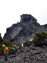
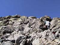
Summit Pinnacle
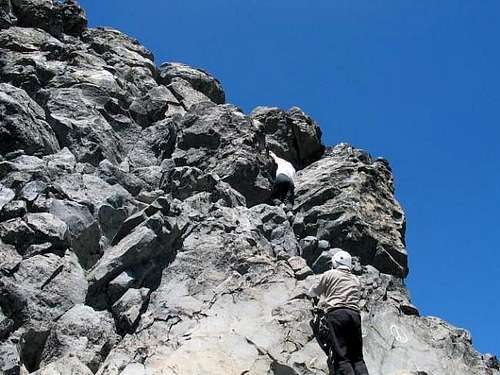
The West Ridge route finishes on a ledge (sometimes called Chicken Ledge for obvious reasons) at the base of the 80 foot summit pinnacle. Ratings for the pinnacle range from class 3 to low 5th depending on the individual and the exact variation of the route, however a class 4 rating seems to be the most common.
The easiest route begins on the far right side of the pinnacle in a short chimney. Alternatively one can begin on the rightmost spine of the pinnacle, this option has better holds, but a fall here would result in a non stop ride to the Lathrop Glacier (in fact, at the time of writing this page, the most recent fatality on this peak came when a gust of wind knocked someone off this route).
From here the route trends left through a series of ledges. Key hand holds have been polished by the many other climbers that came through, when in doubt, look for these to tell if you're on route. The climbing gets easier higher up, the last few moves are less exposed.
 The notch The notch |
Climbing the notch
|
 Looking Up Looking Up |
Compared to the rest of the mountain the rock quality on the pinnacle is quite solid. Still this is the Oregon Cascades and caution should be exercised. All holds should be thoroughly tested.
It seems the majority of people who attempt Thielsen do not even attempt the pinnacle. Most seem content to make it to chicken ledge. Most that do climb the pinnacle do not protect it, this is however a matter of personal comfort, and a fall here would not end well.
 The right side of the summit block The right side of the summit block |
 From the east From the east |
 Climbing the chimney Climbing the chimney |
 The notch where the climb Begins The notch where the climb Begins |
Mountain Conditions
This section of the Oregon Cascades sits in a transition zone between the drier Southern Cascades and the more lush Western Cascades. As a result this area receives weather that is abnormal for the Oregon Cascades. Thunderstorms occur regularly during the summer months, rarely will an afternoon go by without seeing some type of activity.
Thielsen is by far the highest object in this area. If you see thunderheads beginning to build, descend immediately. This peak lives up to its nickname The Lighning Rod of the Cascades.
An up to date forecast can be found here.
The closest webcam for the mountain is the highway 138 webcam located at the junction of highway 138 and 230. The mountain itself is not visable.
The best live view webcam of the mountain is from the Sinnott Memorial Overlook on the Crater Lake rim. A less clear view of the mountain can be had from the Crater Lake Webcam.
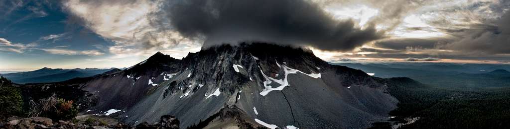
Thielsen engulfed by a thunderstorm
When to Climb
 Lower Slopes in winter
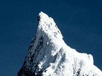 Thielsen's spire in winter
Most people climb Thielsen during the summer months, from July to October. Winter climbing is certainly possible, however the summit pinnacle would be much more challenging when covered in snow and ice. The road to the trailhead is plowed in winter and the trail is marked with blue reflectors. To get an idea of the difficulties a winter climb would entail see this trip report
The lower portions of the mountain offer some decent back-county skiing. See this website for details.
Red Tape
Mount Thielsen is located inside the Mount Thielsen Wilderness. Permits are not required but standard wilderness rules and ethics apply.
A Northwest Forest Pass is required to park at the trailheads during the summer months. These are available at the trailheads. Those Holding an America the Beautiful pass are exempt. From November through April an Oregon sno-park permit is required to park at the trailhead or any of the pullouts on Highway 138.
Camping
 View from the Thielsen Creek Meadows campsite
Dispersed camping is permitted in most places on National Forest Land unless otherwise posted.
The Diamond Lake area has several good campgrounds listed below:
Diamond Lake Campground: Located on Forest road 4795, on east shore of Diamond Lake. 240 campsites (trailer & tent units), tables, fireplaces, running water, flush toilets, showers, garbage bins, grey water sumps, RV dump station, boat ramps, & fish cleaning station. Accommodates trailers to 35'. Some sites designed for persons with disabilities. Reservations available for sites in loops A-F. Daily fees.
Broken Arrow Campground: Located on Forest Road 4795, at south end of Diamond Lake. A combination of 148 trailer and tent units, with tables, fireplaces, running water, flush toilets, showers, garbage bins, grey water sumps, & trailer dump station. Accommodates trailers to 35'. Loops F & G are designed for persons with disabilities us. Group reservations available for loops J, K, M, & N. Daily fees.
Thielsen View Campground: Located on Forest Road 4795, on west shore of Diamond Lake. A blend of 58 trailer & tent units, with tables, fireplaces, running water, vault toilets, grey water sumps, garbage bins & boat ramp. Room for trailers to 30 feet. Some sites adapted for persons with disabilities. Daily fees.
South Shore Area: Five non-motorized campsites adjacent to the South Shore Picnic Area for hikers & bicyclists, with tables, fireplaces, running water, flush toilets, & grey water sumps. No fee.
If approaching through the Thielsen Creek drainage, one can do an overnight trip, camping at Thielsen Creek Meadows beneath the 2700 foot north face of Mount Thielsen. This option is highly recommended.
Contact and Links
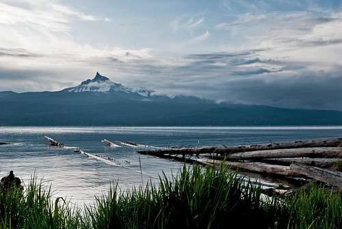 Mount Thielsen from Diamond Lake
Diamond Lake Ranger District
2020 Toketee Ranger Station Road
Idleyld Park, OR 97447
(541) 498-2531
Fax: (541) 498-2515
2020 Toketee Ranger Station Road
Idleyld Park, OR 97447
(541) 498-2531
Fax: (541) 498-2515
Diamond Lake Visitor Center
(541) 793-3310
(541) 793-3310
Diamond Lake Resort
Umpqua National Forest Headquarters
2900 NW Stewart Parkway
Roseburg, OR 97471
(541)957-3200
Fremont-Winema National Forest Headquarters
1301 South G Street
Lakeview, OR 97630
(541)947-2151