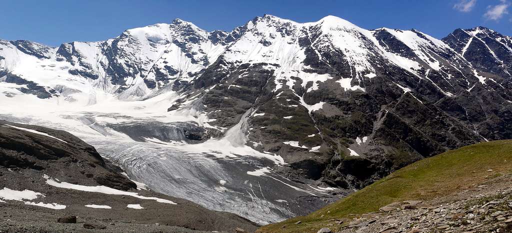
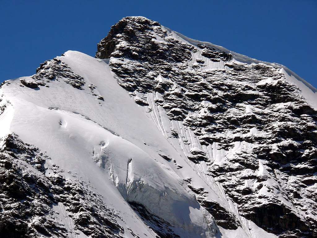
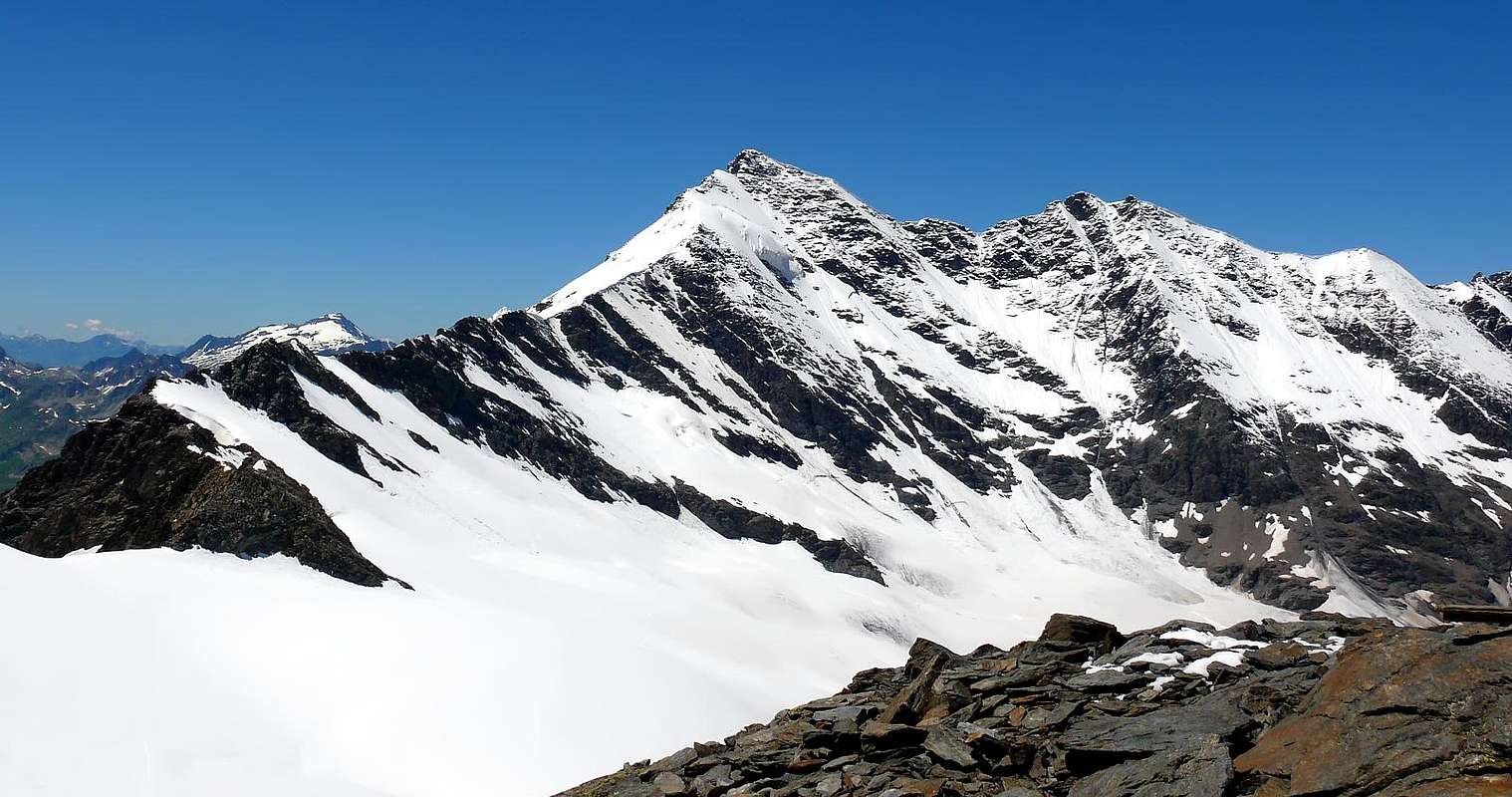
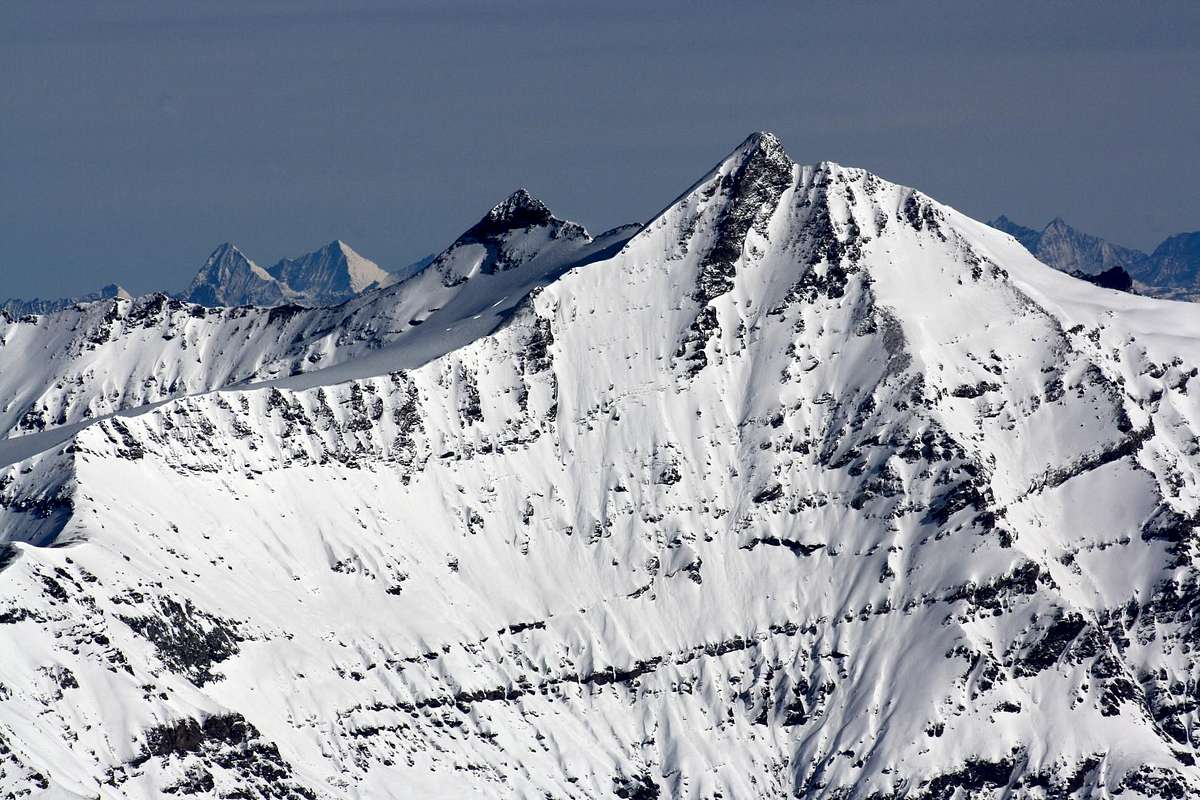
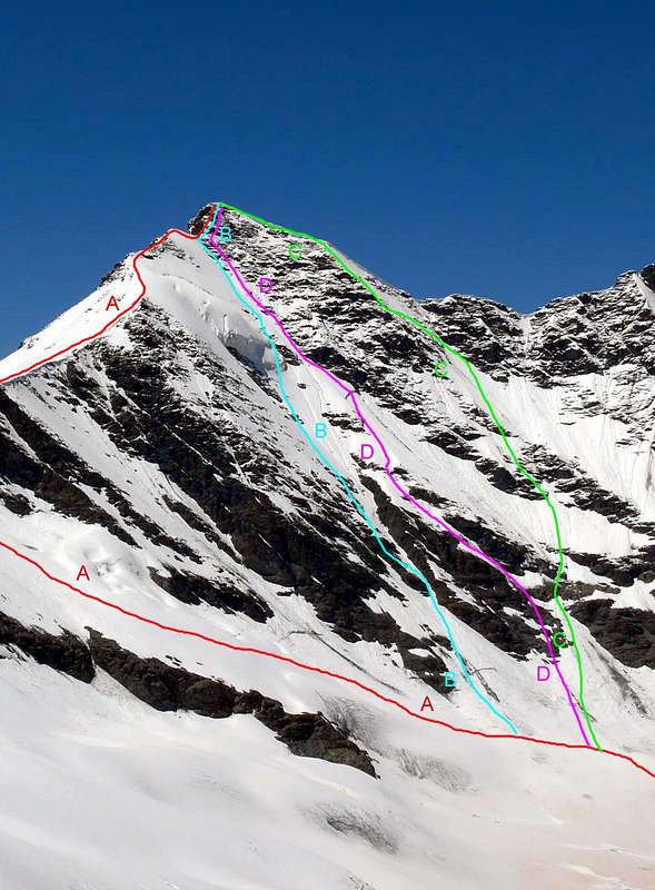
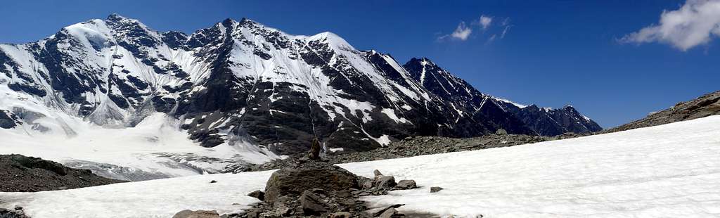
Important and imposing mountain, it is the highest Summit along the border ridge that goes from the sea to Colle della Seigne, before the Petite and Grande Aiguille des Glaciers into a mountain range of Mont Blanc. It is easily seen from Valgrisenche, the main center of the namesake valley, from which it appears as a beautiful pyramid with its snow-covered North Wall. It lies between the long Northern Crest, which descends to Becca di Suessa (3.420m), after having formed the Petite Sassière (3.672m), Punta Nant Cruet or Pointe du Nantcruet (3.510m), Punta Plattes or, as for Giovanni Bobba in "CAI Bulletin XXIV", Pattes des Chamois (3.610m), and the fairly long E-SE Ridge, with this second which leads to Colle della Sassière (the Western 3.240 meters, the Eastern 3.247 meters) and then rise again to Becca della Traversière (3.337m). This last ridge, which constitutes the Italian Normal Route starting from the Mario Bezzi Refuge (2.284m), presents, in addition to that of the two aforementioned hills, various possibilities of engagement on this side, that is from the Glacier de Glairetta. Also on the opposite or French side in the Parc National de la Vanoise in Val d'Isère and, or rather in the Réserve Naturelle de la Grande Sassière, it grants shortcuts, but they are totally inadvisable due to the fragility of the terrain, dangerously landslide above the Vallée de la Sassière with its namesake Lac (2.471m). For the something, arriving from Saint-Foy-Tarenteise (1.051m)and having reached Villaret de Nial(1.815m), go along the initial section of Vallée de la Sassière and then, at the crossroads at the Alpe di Saut (2.278m), turn sharply towards the NW reaching Plan de la Cassette. From this continue towards the Rocher de la Davie (3.156/3.158m) and, flexing slightly to the right (North), you reach the Western Crest, or French Normal Route, which easily leads to the Summit. This third ridge also has, orographically speaking, various extensions with a secondary branch to the SW from an altitude of 3.250/3.270 meters approximately, as well as, beyond the rocky-detrital Summit of the Rocher de la Davie, a more articulated branching suitable for to separate the Plan de Genievre to the W-SW from the Vallon du Nantcruet to the W-NW. As for the slopes and the walls, it should be noted that they have more value from a historical point of view than because they offer great or beautiful climbs. The first climbed was the large Southern Wall, high(over 1.350 meters)from the base just above the Chalets de la Sassière (2.347 m) and extended to over 5 and a half kilometers from Plan delle Cassette (in West) to below the two Colli della Sassière in the East (the Western 3.240 meters, the Eastern 3.247 meters), also passing the very tiny Petit Glacier. While a more "restricted" part, between the bifurcation below the SW / NW E Ridges and the mini glacier, itself reaches almost 4 and a half kilometers in width and the sector below the vertical of the Summit exceeds the Kilometer and a half. Unfortunately, a vastness, mountaineering speaking, "wasted" in its entirety due to the poor quality of the rock, suitable for everything except for climbing as it is made up of Cyrene limescists, chlorite schists or crystalline limestones and arenaceous and carbonaceous limescists of the Jurassic. On the opposite side the North Face descends, between the North Crest, up to the notch called Col de la Petite Sassière to the West and the Western Col of the Sassière to the East. The same, interspersed with a small suspended serac now in the process of disappearing, can be considered divided into two distinct facades with one of which is divided into two specific sectors: 1) - a face facing north-east with the lower and glacial part of greater height and facing decidedly to the East towards the Col de la Petite Sassière and a very short upper part as well as facing North with exit on the North Crest, before this presents a large cornice facing East (see photo below), on which the first route of the wall was traced in January 1917, even if, in reality, the route includes a path more typical of the hill itself than of the wall. 2a) - a face facing North-northeast, which, from the rocky tower of the Vetta, descends glacially, leaving on the right (East) a rocky islet in the shape of a small trapezoid at an altitude of 3.150/3.250 meters approximately, ending at an altitude of about 2.930/2.950 meters inside the Glacier de Vaudet. An itinerary traveled in August 1980 downhill to save time compared to the SE Ridge after the long ridge traverse starting from Col Vaudet (see note in the Mario Bezzi Refuge book of the time). This route descends from the rocky castle of the Cima, leaving the hanging serac on the right (East), flanking just below the long rocky ridge , which separates it from the 1917 route on the NE Face. 2b) - Further to the East-northeast, the wall has a sturdy rocky ridge, which originates at an altitude of 3.588 meters on the last stretch of the SE Ridge and ends at an altitude of 3.016/3.027 meters, almost at the junction of the Glacier de Vaudet with the Glacier de Glairetta at an altitude of a about 2.900/50 meters. A route climbs sinuously from the bergschrund starting at the base of rocky rib and taking itself to the base of the hanging serac at its right end going up else West; passed the same on its external side, it turns diagonally to the SW on the overlying glacial slope reaching the SE Crest at the base of the final rocky turret. This route built on july 1980 does not appear, however, in the annotations of the book of the Mario Bezzi Refuge of the time. Finally, the third or Western Side remains between the North Crest, which rapidly descends above the Col de la Petite Sassière, and the Western Crest or French Normal Route coming from the Rocher de la Davie; the same dominates the Vallon du Nantcruet on which the perpendicular Glacier de la Sassière descends, ending in a rocky bottleneck at an altitude of 2.950/3.000 meters. The climb takes place easily along the same but paying attention to the numerous crevasses, generally elongated transversely. Arrived at an altitude of 3.500 meters you can opt for three different solutions of climb:
a) - continue linearly in the direction of travel towards the East reaching one of the two nearby inlets or Cols de la Petite Sassière (3.588 meters the Southern and 3.598 meters the Northern) at the base of the Northern Ridge and with this to conclude.
b) - Or turn 110° to the right (S-SE) reaching the Western Crest or the French Standard Via.
c) - Completely finish, in a slightly more demanding way, with the West side facing the small triangular final wall which with scarce 250 meters leads directly to the true Summit, overcoming a glacial slope from about 30° to 35° degrees from the which often emerge numerous debris flows.
A final historical consideration: the first real climbers are not known, because an ancient signal was found on the Summit after the first absolute ascent. However, the first known mountaineering ascent is that of August 5th, 1860 by the Englishman William Mathews accompanied by the famous Chamonix Guide Michel Croz who, five years later, will fall on the way back from Matterhorn, after conquest of same.
Montagna importante ed imponente, emerge come la vetta più alta lungo la dorsale di confine che va dal mare al Colle della Seigne, prima della Petite e Grande Aiguille des Glaciers all'interna della catena del Monte Bianco. È facilmente visibile da Valgrisenche, centro principale dell'omonima valle, dalla quale appare come bella piramide con la sua Parete Nord innevata. La stessa risulta compresa tra la lunga Cresta Settentrionale, che scende fino alla Becca di Suessa (3.420 m), dopo aver formato per strada la Petite Sassière (3.672 m), la Punta Nant Cruet oppure Pointe du Nantcruet (3.510 m), la Punta Plattes oppure, come per Giovanni Bobba in "Bollettino C.A.I. XXIV", Pattes des Chamois (3.610 m), e l'abbastanza lunga Cresta E-SE, con questa seconda indirizzantesi al Colle della Sassière (l'Occidentale 3.240 metri, 3.247 metri quello Orientale) per poi rialzarsi alla Becca della Traversière (3.337 m). Sempre quest'ultima cresta, che costituisce la Via Normale italiana partendo dal Rifugio Mario Bezzi (2.284 m), presenta, oltre a quella dei due colli succitati, diverse possibilità di ingaggio su questo lato cioé dal Glacier de Glairetta. Anche sul versante opposto o francese nel Parc National de la Vanoise in Val d'Isère e, o meglio nella Réserve Naturelle de la Grande Sassière, concede delle scorciatoie, ma risultano del tutto sconsigliabili a causa della fragilità del terreno, pericolosamente franoso sopra la Vallée de la Sassière con il suo omonimo Lac (2.471 m). Per la qual cosa, arrivando da Saint-Foy-Tarenteise (1.051 m) e raggiunto il Villaret de Nial (1.815 m), si percorre verso N-NE il tratto iniziale de la Vallée de la Sassière per poi, giunti al bivio presso l'Alpe di Saut (2.278 m), svoltare decisamente verso NO raggiungendo il Plan de la Cassette. Da questo si prosegue in direzione del Rocher de la Davie (3.156/3.158 m) e, flettendo leggermente a destra (Nord), si raggiunge la Cresta Occidentale, o Via Normale francese, che facilmente conduce alla Vetta. Anche questa terza cresta possiede, orograficamente parlando, dei vari prolungamenti con un ramo secondario a SO da quota 3.250/3.270 metri circa, nonché, oltre la Sommità roccioso-detritica del Rocher de la Davie, una ramificazione più articolata atta a separare il Plan de Genievre a O-SO dal Vallon du Nantcruet ad O-NO. Per quanto concerne i versanti e le pareti, da annotare come i medesimi abbiano più valore dal punto di vista storico che non in quanto offrano grandi o belle salite. La prima ad essere scalata é stata la larga Parete Meridionale, alta (oltre 1.350 metri) dalla base appena al di sopra dei Chalets de la Sassière (2.347 m) ed estesa per oltre 5 Kilometri e mezzo dal Plan delle Cassette (ad Ovest) fino al di sotto dei due Colli della Sassière ad Oriente, oltrepassando anche il minuscolo Petit Glacier. Mentre una parte maggiormente "ristretta", tra la biforcazione sottostante le Creste SO/NO ed il ghiacciaietto medesimo, raggiunge quasi 4 Kilometri e mezzo di ampiezza ed il settore al di sotto della verticale della Vetta supera il Kilometro e mezzo. Purtroppo una vastità, alpinisticamente parlando, "sprecata" in toto per la pessima qualità della roccia, a tutto idonea tranne che all'arrampicata poiché composta da calcescisti cirenei, scisti cloritici o calcari cristallini e calcescisti arenacei e carboniosi del Giurassico. Sul lato opposto scende la Parete Nord, compresa tra la Cresta Nord, fino all'intaglio denominato Col de la Petite Sassière ad Occidente ed il Colle Ovest della Sassière ad Oriente. La stessa, inframmezzata da un piccolo seracco sospeso ormai in via di disparizione, può considerarsi divisa in due distinte facciate con una delle quali a sua volta suddivisa in due specifici settori: 1) - Una parete rivolta a Nordest con la parte inferiore e glaciale di maggior dislivello e rivolta decisamente ad Est in direzione del Col de la Petite Sassière ed una superiore molto breve nonché rivolta a Settentrione con uscita sulla Cresta Nord, prima che questa presenti un grande cornicione rivolto ad Est (vedi foto sopra), sulla quale é stato tracciato il primo itinerario della parete nel gennaio del 1917, anche se, in realtà, la via comprende un percorso più proprio del colle medesimo che non della parete. 2a) - Una parete Nord-nordest che, dalla torretta rocciosa della Vetta, scende glacialmente, lasciando sulla destra (Est) un isolotto roccioso a forma di piccolo trapezio all'altitudine di 3.150/250 metri circa, per terminare a quota 2.930/2.950 metri circa dentro il Glacier de Vaudet. Un itinerario percorso nell'agosto del 1980 in discesa per risparmiare tempo rispetto alla Cresta SE dopo la lunga traversata in cresta con partenza dal Col Vaudet (vedi nota nel libro del Rifugio Mario Bezzi del tempo). Questa via scende dal castelletto roccioso della Cima, lasciando sulla destra (Est) il seracco pensile, affiancando sottostantemente la lunga nervatura rocciosa, che la separa dalla via del 1917 sulla Parete NE. 2b) - Più ad Est-nordest la parete presenta un robusto costolone roccioso, che si origina a quota 3.588 metri sull'ultimo tratto della Cresta SE per terminare a quota 3.016/3.027 metri circa, pressocché alla congiunzione del Glacier de Vaudet con il Glacier de Glairetta a quota 2.900/50 metri circa. Una via sale sinuosamente dalla crepaccia terminale portandosi alla base del seracco pensile nella sua estremità di destra salendo od Ovest; superato il medesimo sul suo lato esterno, si indirizza in diagonale a SO sul soprastante pendio glaciale raggiungendo la Cresta SE alla base della torretta finale. Questa via realizzata nel luglio 1980 non appare però nelle annotazioni del libro del Rifugio Mario Bezzi del tempo. Infine il terzo versante od Occidentale rimane compreso tra la Cresta Nord, che rapidamente scende sopra il Col de la Petite Sassière, e la Cresta Ovest o Via Normale francese proveniente dal Rocher de la Davie; il medesimo domina il Vallon du Nantcruet sul quale scende il Glacier de la Sassière terminando in una strettoia o, meglio, strozzatoia rocciosa a quota 2.950/3.000 metri circa. La salita avviene piuttosto facilmente percorrendo il medesimo, ma facendo attenzione agli alquanto numerosi crepacci, in genere quasi parallelamente allungati trasversalmente. Giunti all'altitudine di 3.500 metri circa si può optare per tre soluzioni diverse:
a) - continuare linearmente nel senso di marcia in alto verso Est raggiungendo una delle due insenature (o Col de la Petite Sassière) alla base della Cresta Nord e con questa concludere.
b) - Oppure piegare a 110° verso destra (S-SE) pervenendo alla Cresta Ovest o Normale francese.
c) - Terminare completamente, in modo appena più impegnativo, con il Versante Ovest affrontando la paretina triangolare finale che con 250 scarsi metri circa porta, percorsa nel centro, direttamente in Vetta, superando un pendio glaciale di 30°/35° gradi circa dal quale spesso affiorano numerose colate detritiche.
Un'ultima considerazione storica: non si conoscono i primi veri salitori, perché sulla Vetta venne rinvenuto un antico segnale dopo la salita dell'agosto 1860. Comunque la prima ascensione alpinistica nota risulta appunto quella del 5 Agosto 1860 da parte dell'inglese William Mathews accompagnato dalla celeberrima Guida Chamoniarda Michel Croz che, cinque anni dopo, cadrà sulla via del ritorno dal Monte Cervino, dopo la conquista dello stesso.
First Ascents
W-SW Arête: Inhabitants of Tignes valley and soldiers, (1808?).
W-SW Arête: W. Mathews with M. Croz, (Aug 5th, 1860), first recorded ascent.
S-E Arête: W. A. B. Coolidge with Christian Almer (father and son), (Aug 06th, 1878).
S-E Arête: First Italian ascent: Filippo Vallino with guides Antonio Castagneri and G. B. Bich, (Aug 01th, 1885).
S-E Crest from Colle della Sassière: Giovanni Bobba and Casimiro Therisod, (Aug 17th, 1889) in descent.
S Wall: R. and M. Godefroy, (Sep 06th, 1893).
S Wall: H. Mettrier (solo), (Aug 22th, 1901).
S-W Wall and SE Arête: Giuseppe Quaglia and Francesco Sitia, (Aug 1919).
N Arête (from Glacier du Fond): Giovanni Bobba and Casimiro Thérisod, (Aug 17th, 1889).
E-NE Wall: Aldo Bonacossa and L. Hosquet, (Jan 30th, 1917).
N-E Wall (Route of the Serouac): Cleto Frassy and Danilo Garin, (Jul? 1980?).
N Arête (Integrale from Col Vaudet or Col di Suessa): Osvaldo Cardellina, Camillo Roberto Ferronato and Giuseppe Lamazzi, (Aug 24th, 1980).
N-NE Wall (Direct route in descent): Osvaldo Cardellina, Camillo Roberto Ferronato and Giuseppe Lamazzi, (Aug 24th, 1980).
Getting There
BY CAR:
From Torino, Milano, etc: Motorway A5. Exit at Aosta Ovest. Drive on SS.26 toward Mont Blanc as far as Leverogne (780m).
From Switzerland: through the Grand Saint Bernard Tunnel or the namesake Pass. Drive to Aosta, then follow the direction for Courmayeur on SS.26 as previously, reaching Leverogne.
From France: through Mont Blanc Tunnel or Petit Saint Bernard Pass. It is not necessary to take Motorway A5: you can drive on SS.26, in the direction of Aosta as far as Leverogne.
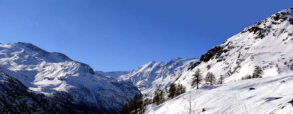
Once close to the Village of Leverogne (780m), turn left if you come from Aosta or turn right coming from Mont Blanc, following along the Regional Route for Valgrisenche. Pass many small Villages, including Rochefort, La Ravoire, Chamencon, La Bethaz, and Valgrisenche (1.664m), the main center of the namesake valley. Turn right for the Village of Bonne (1.810m) located near the western summit edge of the huge dam that forms the Beauregard Reservoir, practically empty for technical reasons. Past the small Village of Menthieu (1.842m), continue for approximately 5 km along the paved road, which follows parallel to the western shore of the lake, running high above it, and then descend leading to the old Pasture of Surier (1.758m), near the Village of Usellières (1.758m) at the southern end of the lake basin. Before the village there is a ample parking space where you can leave the car.
BY PLANE:
Aeroporto "Corrado Gex" Saint Christophe (Aosta).
Route
The route described here is the Italian Standard Route along the Southeast Ridge from Colle Orientale della Sassière (3.274m). Really, the true standard route is the Western Ridge, from Glacier de la Sassière (North) and Réserve Naturelle de la Grande Sassière (South), which is entirely in France.
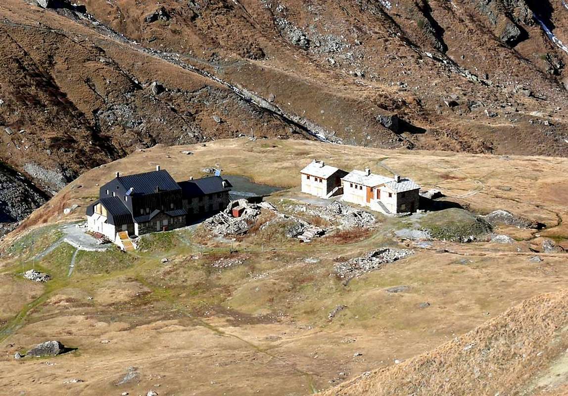
Starting from the parking near the Village of Usellières (1.758m), continue on foot on the dirt road that leads to Rifugio Mario Bezzi (2.284m; two hours from the parking lot). From Rifugio Mario Bezzi (2.284m) take trail 12c (Alta Via n° 4) that gently rises through meadows in the Southeast direction. Turn South and traverse a grassy slope below Pian di Vaudet; cross the Stream named La Cuire and the next one that flows from Ghiacciaio di Bassac, below Grand Traversière, to reach a bench strewn with large boulders left by a rockfall. Climb S-SE up ridges where grass alternates with scree. Following numerous cairns, surmount a broken rock band along a gully which is below the Glacier of Bassac Déré. The gully leads to a head with rocks and grass. From there, continue on level ground to pass three bends in the glacier with good views of several tarns below. Once at the Northeast boundary of Ghiacciaio di Gliairetta, trail 12c turns East to go round Col Bassac Déré, between Punta Bassac Déré (North) and Becca della Traversière (South). Leave the trail and trace a wide arc aiming south toward Colle Orientale (East) della Sassière with Becca della Traversière (3.337m) to the East. Reach the col after crossing the bergschrund. (Leave another, higher bergschrund to your West.) A short slope with an angle between 30° and 35° takes to the the border (E-SE) ridge with an elevation gain of less than 150m. Pass a flat rocky and snowy hump on the Val d’Isère side, and with minimal loss of elevation reach Colle Occidentale (3.240m).
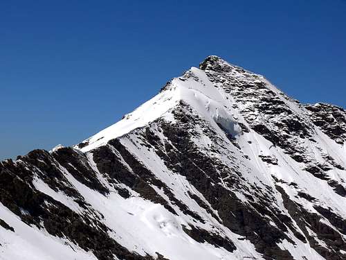
From there, follow the crest of the ridge or stay slightly below on the Southern Side (toward Val d'Isère) on easy rocky ledges. Pass points 3.278 and 3.307m by an easy cliff (still on the South side) and gradually turn Northwest, passing altitude 3.407 along easy slabs with cracks and gullies filled with detritus, and aiming for the Summit tower. (In this stretch, it is possible to find small cornices to the North).
The Summit tower consists of 70/80 meters of broken rocks that are easily climbed (I°+ or maybe II°-/II°) along a gully and natural rocky steps. From the tower continue on easy ground to the aerial Summit (3.751m), paying close attention in case of fresh snow.
Descent: by the same route.
La via qui descritta è la Via Normale italiana lungo la Cresta Sudest dal Colle Orientale della Sassière (3.274 m). In realtà la vera Via Standard consiste nella Cresta Ovest, dal Glacier de la Sassière (Nord) ed internamente alla Réserve Naturelle de la Grande Sassière (Sud), interamente in Francia. Partendo dal parcheggio nei pressi del Villaggio di Usellières (1.758 m), si prosegue a piedi sulla strada sterrata che porta al Rifugio Mario Bezzi (2.284 m a due ore dal parcheggio). Dal Rifugio Mario Bezzi (2.284 m) s'imbocca il sentiero 12c (Alta Via n° 4) che sale dolcemente tra i prati in direzione Sudest. Svoltare a Sud e attraversare un pendio erboso al di sotto del Pian di Vaudet; indi si attraversa il Torrente La Cuire e il successivo che sgorga dal Ghiacciaio di Bassac, giusto al di sotto della Grand Traversière, per raggiungere una banconata disseminata di grossi massi lasciati da una frana. Salire verso S-SE su crestine dove l'erba si alterna al ghiaione. Seguendo numerosi ometti, si supera una fascia rocciosa spezzata lungo un canalone trovantesi al di sotto del Ghiacciaio di Bassac Déré. Il medesimo porta ad un promontorio con rocce ed erba. Da lì si prosegue in piano per superare tre tornanti nel ghiacciaio con bella vista su diversi laghetti sottostanti. Giunti al confine Nordest del Ghiacciaio di Gliairetta, il sentiero 12c piega a Est per aggirare il Col Bassac Déré, tra Punta Bassac Déré (Nord) e Becca della Traversière (Sud). Lasciare il sentiero e tracciare un ampio arco in direzione Sud verso il Colle Orientale (Est) della Sassière con la Becca della Traversière (3.337 m) ad Oriente. Raggiungere il colle dopo aver attraversato la crepaccia terminale. (Si lascia un altro crepaccio terminale più alto ad Ovest.) Un breve pendio con un angolo tra 30° e 35° porta alla dorsale di confine (E-SE) con un dislivello inferiore a 150 m. Superare un dosso pianeggiante, sia roccioso che nevoso, sul versante della Val d'Isère e con minimi dislivelli raggiungere il Colle Occidentale (3.240 m).Da lì si segue il filo di cresta oppure si resta leggermente più in basso sul Versante Sud (verso la Val d'Isère) su facili cenge rocciose. Superare le quote 3.278 e 3.307 m per una facile falesia (sempre sul lato Meridionale) e piegare gradualmente verso Nordovest, passando per la quota 3.407 su facili placche con fessure e canaloni quasi ricolmi di detriti, e puntando alla torretta sommitale. (In questo tratto è possibile trovare delle piccole cornici esposte a Nord). La torre sommitale è costituita da 70/80 metri di rocce alquanto rotte e spezzate, quasi frantumate, ma facilmente scalabili (I°+ o forse II°-/II°) lungo un canalone e gradini rocciosi naturali. Dalla torre si prosegue su terreno facile fino all'aerea Vetta (3.751 m), prestando molta attenzione con neve fresca.
Discesa:tramiite lo stesso percorso.
Difficulty
This route is rated PD+. Pay attention to the many crevasses of Ghiacciaio di Gliairetta and, on the ridge, to the North-facing cornices.
Questo percorso è classificato PD+. Attenzione ai numerosi crepacci del Ghiacciaio di Gliairetta e, in cresta, alle cornici esposte a Nord.
Gear
Mountaineering equipment including rope, crampons, and ice axe.
Equipaggiamento da alpinismo inclusivo di corda, ramponi e piccozza.
Parents refers to a larger category under which an object falls. For example, theAconcagua mountain page has the 'Aconcagua Group' and the 'Seven Summits' asparents and is a parent itself to many routes, photos, and Trip Reports.

 30018 Hits
 94.96% Score
 50 Votes