La montagna chiama i suoi figli, ed essi rispondono fedelmente al suo appello…
Osvaldo Cardellina, Diario alpinistico, 1964-65
Page texts: @ OsvaldoCardellina"Osva", passed away on May 2, 2022. Page owners: Christian Cardellina e Osvaldo Cardellina. Any updates from September 12, 2022: Antonio Giani, page administrator, friend and climbing companion.
Testi della pagina: @ OsvaldoCardellina "Osva", scomparso il 2 maggio 2022. Proprietari pagina:Christian Cardellina e Osvaldo Cardellina. Eventuali aggiornamenti dal 12 settembre 2022: Antonio Giani, amministratore della pagina, amico e compagno di salite.
Overview
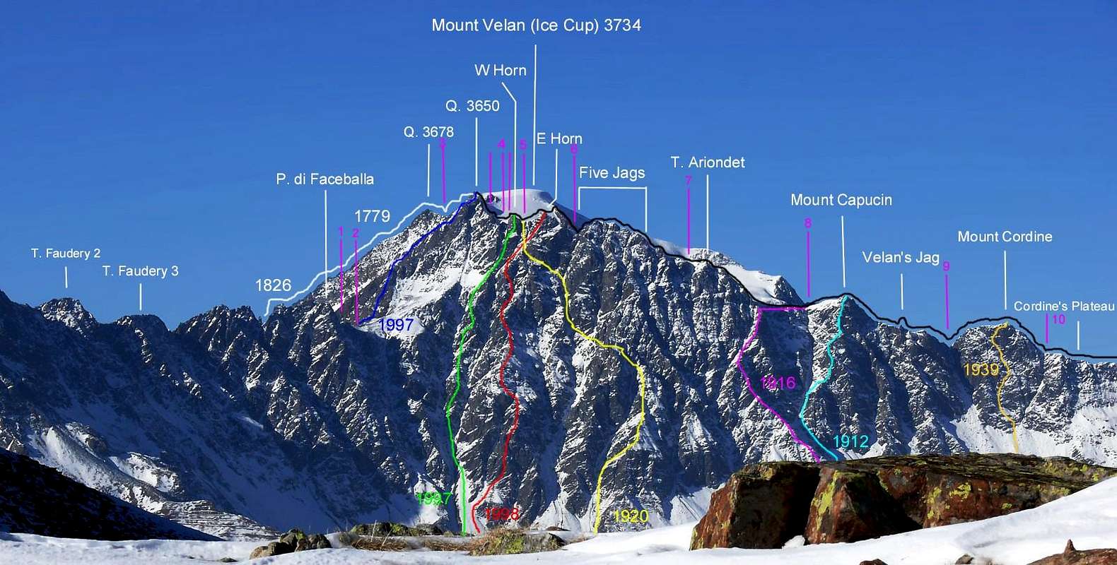
A brief summary of all the routes known at Mont Velan or Vélan and, for the local inhabitants, Mont V'lan. The personal criterion, specifically wanted and chosen, consists in has been maintained to proceed in an anti-clockwise direction starting from the West Ridge (the side with the sector more Western of the entire mountain), overlooking the Colle di Annibale or Hannibal's Pass , which constitutes the route of the first climbers on August 31th, 1799, by the Monk-Naturalist Laurent-Joseph Murith with the local hunter Genoud; even if the first section was traveled on the Proz 's Glacier side to then join it to two thirds of the route at the overlying and overhanging minuscule Aiguille du Déjeuner (3.346m). Then, to follow, the itineraries of the Southwest Versante (Slope, broken into two sectors: with the Mont Velan Glacier at the superior part and a half-dozen grassy-rocky bouncing down and big ribs below, interspersed with steep detrital gullies), above the double Vallone (great valley) of Menouve and Molline also Moline in turn above the Municipality of Etroubles(1.280m, 14,8 km from Aosta Town). The same reaches the Sella di Faceballa (often snowy or with debris and some boulders a wide saddle in altitude of 2.880m), from which it gives birth to the long Contrafforte (Buttress) South-soutwest that end, safter having formed numerous peaks including La Salliaousa(3.322m) at Mont Saron(2.631m), just above the Municipality of Allein. Then from this the streets of the Southeastern Side that wind from the border ridge with Switzerland, which, gradually descending, turns towards East-Northeast up to reach Colle di Valsorey(3.107m). This magnificent wall, well visible from the City of Aosta, falls with broken ribs and filthy gullies, sometimes snow-covered or even icy, for about 900 meters and more at its highest point, which corresponds to the altitude of 3.650 meters, where the ridge begins to bend first towards North-northwest and then decidedly to the West and then, as already mentioned, to descend to the Hannibal's Pass. Looking from a distance you can understand how the rounded and iced summit dome (3.734m) constitutes the true summit, all surrounded by a series of secondary spiers which, however, if seen from a short distance (especially from below), constitute a certain "disturbance" for the topographical understanding of the mountain. In reality it is, starting from the summit of the West Crest above Il Colle di Annibale, that a series of Quotas characterized by the altitudes of 3.678, 3.708m, 3.672m and 3.650 meters dominate the high Vallone di Molline (continuation but with splitting from that of Menouve); just the last of these is the "pivot" that allows you to discern those above the Comba Berruard inside the Conca (By's Basin) di By. From this the discourse and analysis is more complicated (and not a little) in direction of the Colle di Valsorey(3.107m). We see them in detail starting from this last one and towards East first and then East-northeast, including the respective brèches or carvings and notchs as well as the passes along the border Italian/Swiss on the highest watershed: from the first Southern altitude or Quota 3.650 meters of Mont Velan; after downhill up the serie of Western Minihorn(3.623m~), at the subsequent with bifid top Brokenhorn(3.612m), to the three and to the following ones and much in plain view (the extremes because the smaller Central of about 3.610/15 meters is not very evident if not with knowledge on site) V'lan's Horns(3.620 meters the Western, Eastern Brèche 3.610/2 meters about, 3.615 meters the Mini Central, about 3.618 meters the Eastern), then towards the five Velan's Jags(about from 3.570 meters to 3.595 meters), just detached to the East the Little Velan's Tooth(about 3.530/35 meters), to the most low Tête d'Ariondet also Testa di Riondet(3.485m), Mont Capucin(3.395m), to lonely and isolated Doigt(Velan's Finger)du Velan, to carving of Col des Chamois(3.259m), to the last summit of Mont Cordine(3.329m), at the before snowy after debris great Plateau de Cordine(3.221m) up to the Valsorey's Col or Pass(3.107m), last passage on the border ridge of a certain ease up to the Amiante's Pass and the neighbor of By(3.308 meters, 3.224 meters, for the mountaineering but inappropriate to normal transit) and the now very distant, large and comfortably passable Fenêtre Durand(2.805m), adressed towards the rather long Bagnes Valley, starting from Sembrancher Hamlet(712m) towards those of Lourtier(1.489m), Fionnay and Mauvoisin(1.840m) and with at the superior part the presence of the Chanrion's Cabane(2.462m). Let us say, however, that confusion and uncertainty can only exist until the last of the six teeth of V'lan, since from Testa d'Ariondet or Testa de Riondet the topographical vision becomes much clearer and delineated, clearing any possible error or confusion. This is true, as we shall see in the appropriate and subsequent treatment of the routes, also for the opposite Swiss side.
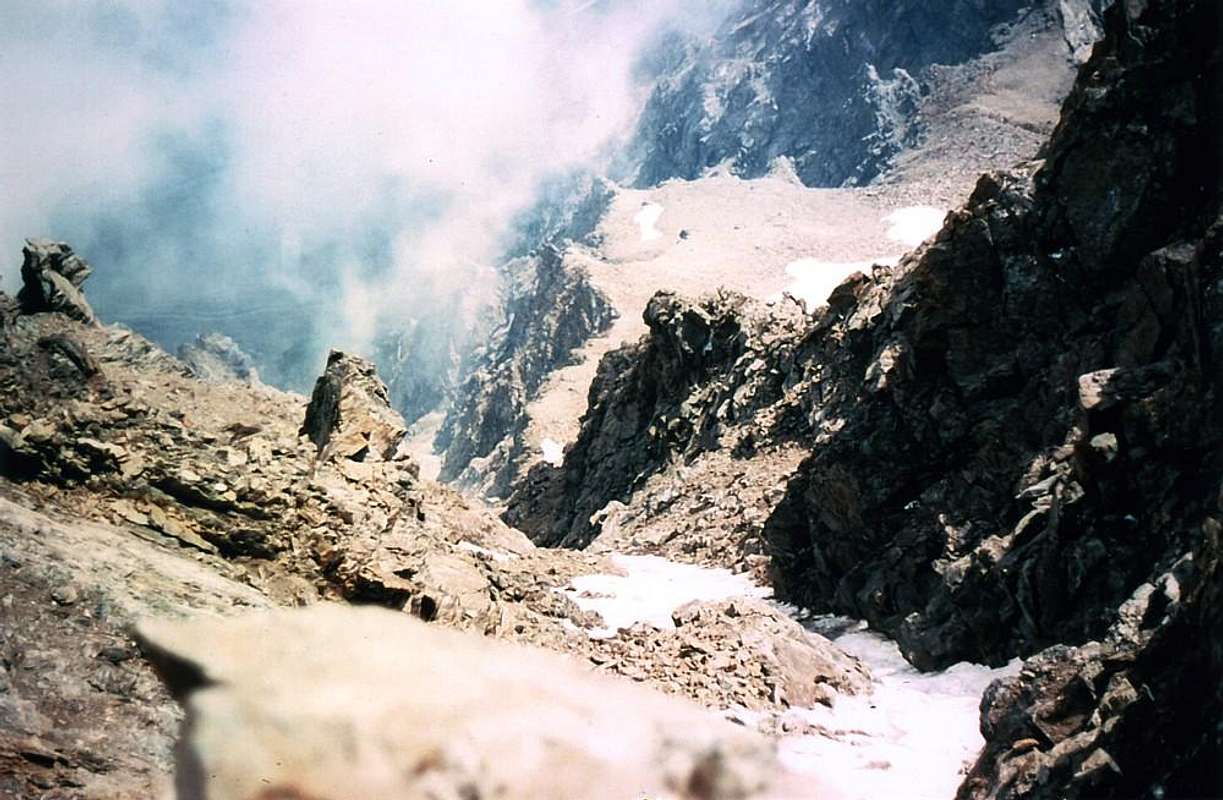
Icy climb on the East-northeast Slope, by Marco Cossard "Crevassino"
Un sintetico riassunto di tutte le vie conosciute al Mont Velan o Vélan e, per i locali, Mont V'lan. Si é volutamente mantenuto il criterio di procedere in senso anti orario partendo dalla Cresta Occidentale, sovrastante il Colle di Annibale(2.922 m), che costituisce la via dei primi salitori; anche se il primo tratto venne percorso sul lato del Ghiacciaio di Proz per poi congiungersi alla medesima a due terzi del percorso presso l'Aiguille du Déjeuner(3.346 m). Quindi, a seguire, gli itinerari del Versante Sudovest (spezzato in due settori: con nella parte superiore il Ghiacciaio del Mont Velan ed al di sotto una mezza dozzina di costoloni erboso-rocciosi, intercalati a ripidi canaloni detritici), al di sopra del doppio Vallone di Menouve nonché di Molline oppure Moline a sua volta soprastante il Comune di Etroubles. Il medesimo raggiunge la Sella di Faceballa (2.880 m), dalla quale "partorisce" il lungo Contrafforte Sud-sudovest terminante, dopo aver formato numerose cime tra le quali La Salliaousa(3.322 m), al Mont Saron(2.631 m), appena al di sopra del Comune di Allein. Poi da questa le vie del Versante Sudorientale che si snodano dalla cresta di confine con la Svizzera, la quale, gradualmente, scendendo, si rivolge verso Est-nordest fino a raggiugere il Colle di Valsorey(3.107 m), tra la Conca di By e l'opposta nonché adiacente Valsorey. Questa grandiosa muraglia, ben in vista dalla Città di Aosta, cade con costoloni rotti e sozzi canaloni, a volte innevati od anche ghiacciati, per circa 900 metri ed oltre nel suo punto più elevato che corrisponde alla Quota 3.650 metri, dove la cresta inizia a piegare dapprima verso Nord-nordovest e poi decisamente ad Ovest per poi, come già detto, calare al Colle d'Annibale. Guardando da distante si comprende come l'arrotondato e ghiacciato cupolone sommitale (3.734 m) costituisca la vera vetta, tutta attorniata da una serie di guglie secondarie che però, se viste da breve distanza (soprattutto da sotto), costuiscono un certo "disturbo" per la comprensione topografica della montagna. In realtà è, proprio partendo dalla sommità della Cresta Ovest sopra Il Colle di Annibale, che si dispiegano una serie di Quote contraddistinte dalle altitudini di 3.678 m, 3.708 m, 3.672 m e 3.650 metri dominanti l'alto Vallone di Molline (continuazione con sdoppiamento da quello di Menouve); proprio l'ultima di queste costituisce il "perno" che permette di discernere quelle al di sopra della Comba Berruard all'interno della Conca di By. Da questa il discorso e l'analisi si complica (e non di poco) in direzione del Colle di Valsorey(3.107 m). Le vediamo in dettaglio partendo da quest'ultima e verso Est dapprima e quindi Est-nordest, comprese le rispettive brèches od i colletti ed intagli nonché i colli lungo lo spartiacque Italiano/Svizzero a partire dalla Quota 3.650 metri del Mont Velan scendendo all' Occidentale Mini Horn(3.623 m~), al successivo Broken Horn ("Corno Spezzato"; 3.612 m), ai successivi e ben più evidenti (gli estremi perché il Centrale di circa 3.610/15 metri risulta poco evidente se non con conoscenza in loco) tre Corni del Velan' di 3.620 metri l'Occidentale, alla Brèche Orientale di circa 3.610/2 metri, ai 3.615 metri circa quella Mini Centrale, ai 3.618 metri del Corno Orientale, alla Brèche Occidentale 3.610/2 metri circa, a quella Mini Centrale 3.615 metri circa, all'Orientale 3.618 metri circa ), poi ai cinque Denti del Velan(all'incirca dai 3.570 metri ai 3.595 metri), il più Piccolo Dente del Velan(pressappoco di 3.530/35 metri), alla più bassa Tête d'Ariondet oppure Testa di Riondet(3.485 m), al Mont Capucin(3.395 m), all'isolato e solitario Doigt(Dito del Velan)du Velan(3.314 m), all'intaglio del Col des Chamois(3.259 m), all'ultima sommità del Mont Cordine(3.329 m), al successivo nevoso eppoi detritico nonché inclinato gran Plateau de Cordine(3.221 m) insino al Colle di Valsorey'(3.107 m), ultimo passaggio sul crinale di confine di una certa facilità fino ai Colli di Amiante ed al viciniore di By (3.308 m, 3.224, alpinistici ma inopportuni al normale transito) ed alla molto lontana Fenêtre Durand(2.805 m), indirizzata verso la piuttosto lunga Val de Bagnes partendo da Sembrancher a Mauvoisin, nonché con nella parte superiore la presenza della Cabane de Chanrion(2.462 m). Diciamo però che la confusione e l'incertezza possono sussistere soltanto fino all'ultimo dei, complessivamente, sei Denti del V'lan, poiché dalla Testa d'Ariondet la visione topografica diventa molto più chiara e delinata, sgombrando ogni errore o confusione. Ciò vale, come vedremo nell'appropriata e successiva trattatazione delle vie, pur per l'opposto versante svizzero.
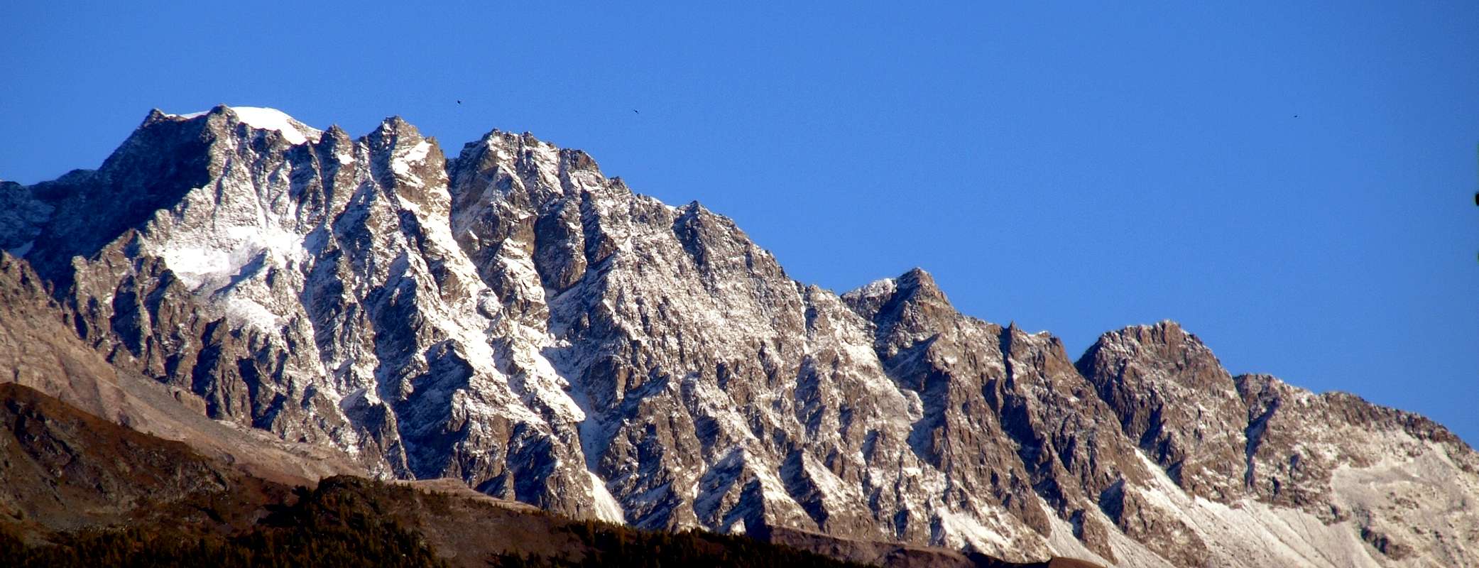
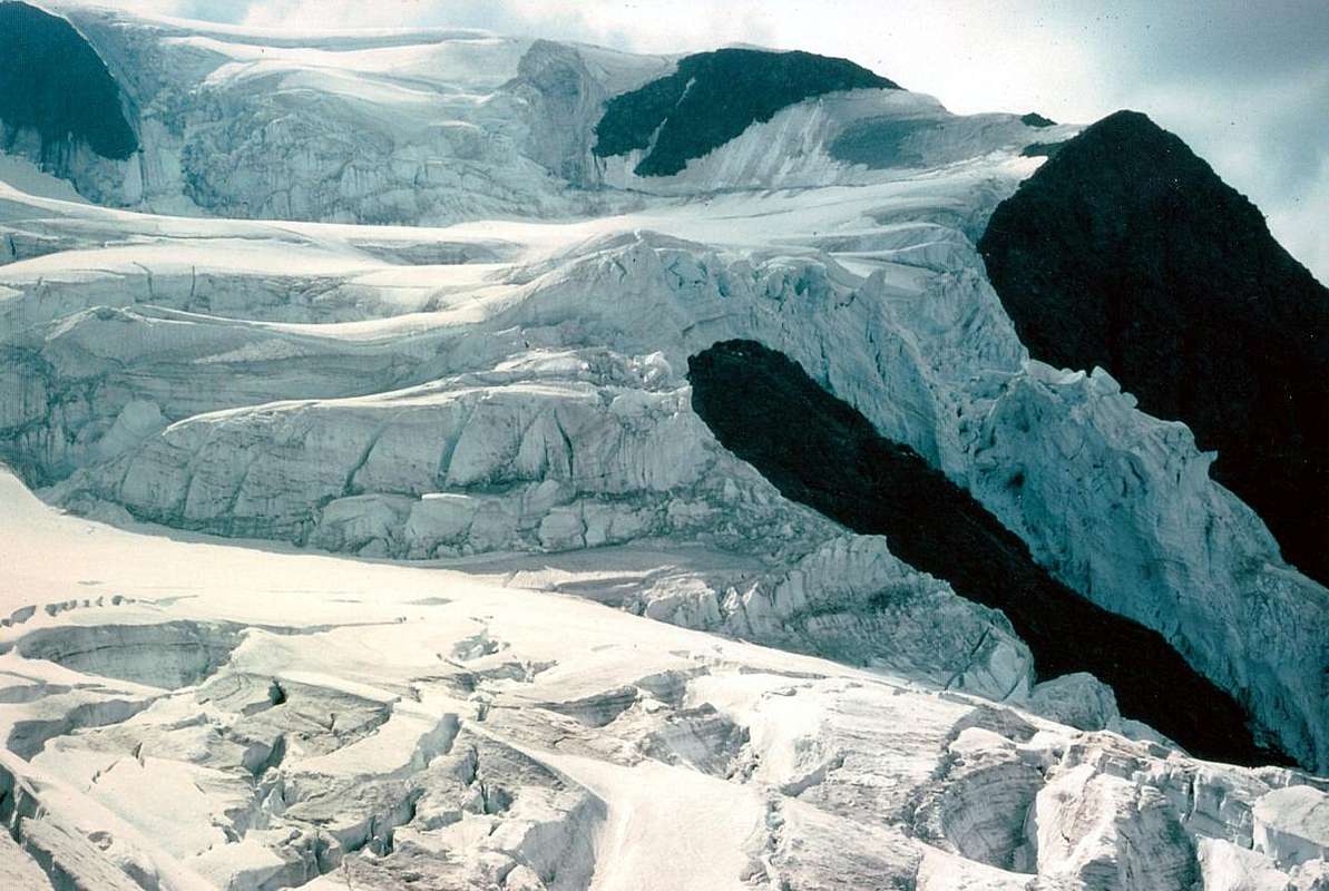
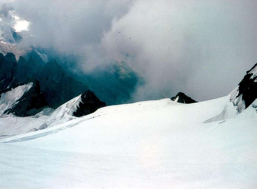
The very long and inclined East-southeast Slope of Mont V'lan from the Central Aosta Valley (in the full shade the Southwestern Face)
Getting There
BY CAR:
From TORINO, MILANO, etc: Motorway A5. Exit at IVREA or Quincinetto (PIEDMONT).
From IVREA Town: before in West to Aosta, after in Northwest to Gignod, Etroubles, Saint-Oyen, Saint Rhémy en Bosses, (Southwestern and Northwestern Sides) and in North to Allein, Doues, Valpelline Municipalities.
From Courmayeur Resort: before in East to Aosta, after in Northwest to Gignod and in North to Allain, Doues, Valpelline and Ollomont Municipalities.
From Aosta Town to Allein and Doues Common in By Basin. From Aosta City towards Variney Fraction and Gignod Commune (988m) with Great Saint Bernard SS.27 up to the alternative 1.074 meters, just before Condemine Hamlet (1.137m). Before crossing North the Artanavaz Torrent or Buthier de Bosses after in the Northwest towards Allein Municipality; from the fork 1.253 meters nearby this last, always with the Regional Road in Northeast, towards Doues From Allain/Doues to Ollomont/Valpelline Communes with By Basin From Allein Commune(1.251m), with Regional and Municipal Roads, to By Basin; from the entrance of this (various alpages reached by private dirt farms roads), through paths, up to the Mont Saron Southern Antesummit (2.681m) and traverse on crest to Tête de la Praz (2.751m) and Crou de Bleintse (2.824m). From Doues Commune(1.176m), with in asphalt Municipal Road, to By Basin; from this, with paths or dirt roads, to Mont Saron (2.681m),Crou de Bleintse (2.824m), Letey Refuge below Champillon Pass (2.430), Mont Chenaille two Summits (3.144m), Tsa d'Ansermin (2.388m) and Monte Rotondo (2.572m). From Ollomont Commune (1.356m), trhough noumerous paths and various upper private dirt farms roads, towards the By Conca; from this numerous routes in all directions up to the Maria Cristina Rosazza at Savoie Bivouac (2.674m), nearby the Bégno Bà or Bas Hill.
From Aosta Town to Ollomont Common in the homonym Valley.
From Aosta City towards Variney Fraction up to the alternative 786 meters (Savin Hamlet); continue North with the Regional Road towards Moulins between the two Torrents Rio Artanavaz also called Buthier de Bosses and Buthier de Valpelline, Rhins, Collin, Creusevy, Chanodaz, Liarey, Fabrique, Chez-les-Chuc Villages reaching in the Northeast Valpelline-Les Ansermins Municipality (996m). At the subsequent crossroads 1.059 meters (Chez-Cailleur Hamlet) turn left (North-northwest) reaching Chez-Collet, Clapet, Vesey Villages and Ollomont-Cognen Common (1.356m); continue North along the Buthier d'Ollomont towards Rey, Vaud, Glacier or Glassier(1.562m) Villages. From this towards the Refuge Franco Chiarella-Amiante (2.979m), Filon Alp (2.478m), Bonne Mort Pass (2.646m), Fenêtre Durand Hill (2.797m), Nino Regondi Bivouac (2.599m) and Lakes, Tsa de Berrio Alp (2.165m), Cormet Hill (2.354m) and Breuson Hill (2.194m).
All Routes description from Conca di By/Comba Berruard
From Faceballa Saddle (left or West, 2880m) Southeastern Face with the "Diagonal Route" above Comba Berruard into the Conca di By by "Faustin" Savoye
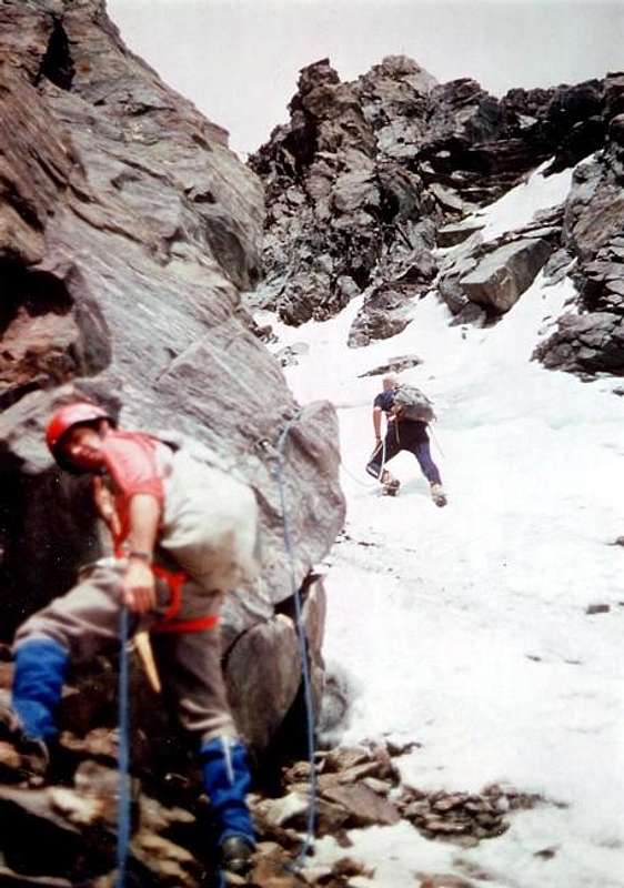
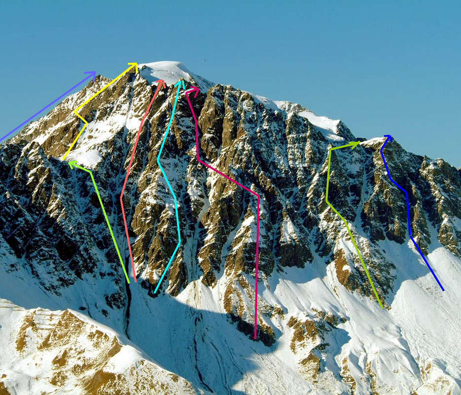
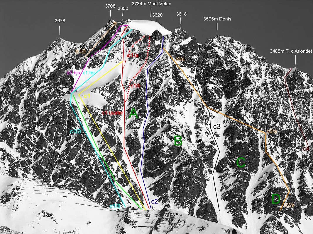
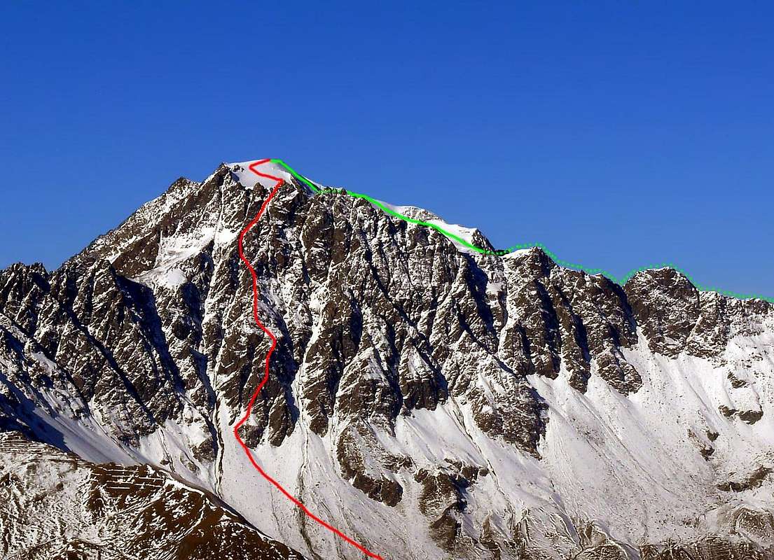
From South-southwest Ridge on watershed with Southwestern Face, VELAN Southern Face from left (most Western Side and above Comba Berruard) * South-southwest Ridge integral: July 27th, 1997, Osvaldo Cardellina, solo; in descent from Quota 3.650 meters to Molline/Menouve Valleys, after the ascent on Northeast Wall of Quota 3.708 meters. PD/PD+/AD-, with brief various steps of I°/I°+/II/II°+ and one of III° on rock; in descent from the Quota 3.650 meters to the base at 3.076 meters under the Southwestern Face; 1h'45/2h'15. In ascent from the base 3.076 meters up to the Quota 3.650 meters, where the summit crest and besides border ridge turn to the East; 2h'30/2h'45'. This ridge can be more easily crossed by the Sella di Faceballa and therefore neglecting the initial part, which originates with a deviation towards the Vallone di Molline from a height of 3.076 meters. So in this case you can start from both sides of the hill (Molline and Conca di By-Berruard sides). HISTORICAL and PRACTICAL NOTE: this crest had been climbed in the final part with descent by a group of roped climbers on August 16th, 1890 (Carr & Companions) and partially in ascent with variant before preceding for a short stretch and after just over the "Diagonal Route" from Faceballa Saddle, by Gino Buscaini and its wife Silvia Metzeltin on October 31th, 1970. This, of July 1997, instead is the sole ascent complete ed integral personally known and also in mountaineering literature (see just below). This ridge is not made either on the Menouve-Molline Vallons (West) side or on the By-Berruard side (East), since the climb along the large Southeastern great Couloir is preferred, which has been followed even downhill on skis in the last two decades. It should be noted that, especially in well-transformed snow conditions (generally in late spring), the same can become, if not easier, certainly less dangerous due to the fall of stones (given the glue capacity of the snow); nevertheless, great attention must be paid to the state of the same and the relative temperatures in order not to incur the risk of snowslides or avalanches. In addition, the ascent in day starting from the Village of Glacier also Glassier(1.562m), in the Ollomont Valley, must be considered an excellent test of physical endurance and therefore requires not only an equally technical background. However compensated by a fast descent on skis, while the "ancient" ascents on foot in all day long (perhaps starting from the distant Champillon shelf) always remain "mythical" undertakings, as in the first winter ascent of December 28, 1904 with departure at 2 hours from the Alpe di Champillon, near the homonym plain, (Evanzio Blanc with the Abbots Valérien Jaccod and the very strong Pantaléon Bovet). On the occasion, however, the same avoided the "lower" part, preferring to climb from the East to the Sella di Faceballa (2.880m), and then insert it into the gully. So they too avoiding the South-southwest Ridge. Or as in the descent (partially in the "high" part of the ridge and then along the entire gully) of August 16, 1890 (Ellis Carr, William Martin Conway, F.M. Davies with the Swiss guides Ulrich Kaufmann and Joseph Marie Lochmatter); In addition, the first entire ascent of the gully is to be credited to the Abbots Pantaléon Bovet and Joseph Henry, on June 14, 1904.Not to mention the "eternal" approaches, which took place on foot or at the back of a mule. Still another thing is the climb in the presence of "verglass"... From Comba Berruard/Conca di By: * Faceballa Saddle to the South-southeast Face: Gino Buscaini and Silvia Metzeltin Buscaini, Oct. 31th, 1970; short variant, of secondary importance, through the Little Saddle or and better a Carving3.450 meters about, with a brief stretch, skirting in right or East a small gendarme, on South-southwest Ridge and final part by South-southeast Wall in ascent; probably with more safe route in respect to the "Diagonal Via" of July 1976 and also to route into the parallel great couloir of a group roped climbers in August 1890. Descent trhough the first "Direct Route" on Southwest Face before to suspended and interrupted Velan's Glacier, after to Molline Vallon. Important remark:(since 2005 until actually, a homonym bivouac in existance at the altitude of 2.415 meters above a grassy promontory just to the left by the Molline Torrent). PD/PD+/AD-, with brief various steps of I°/I°+/II/II°+ and one of III° on rock; in ascent to Quota 3.650 meters from Faceballa Saddle (2.880m)2h'30/2h'45; 6h'00/6h'30 by Savoie Bivouac (see also above).
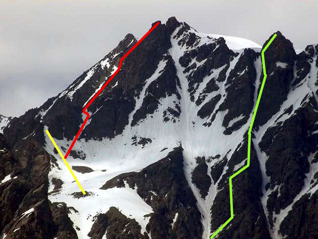
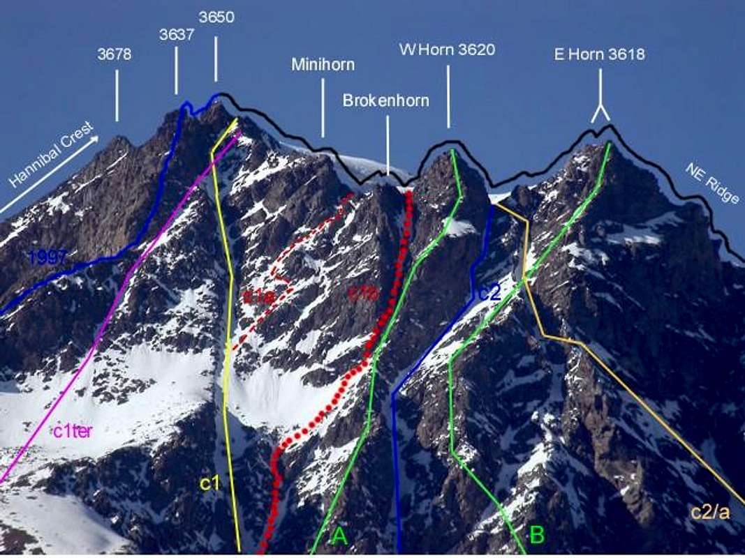
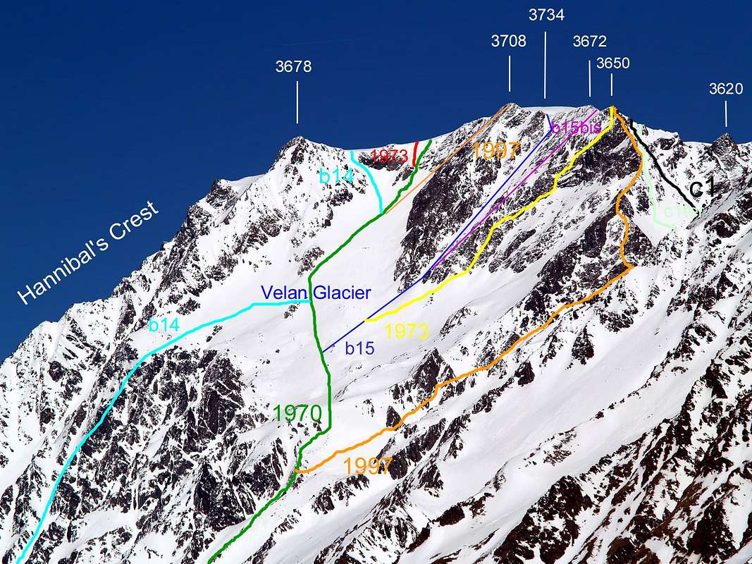
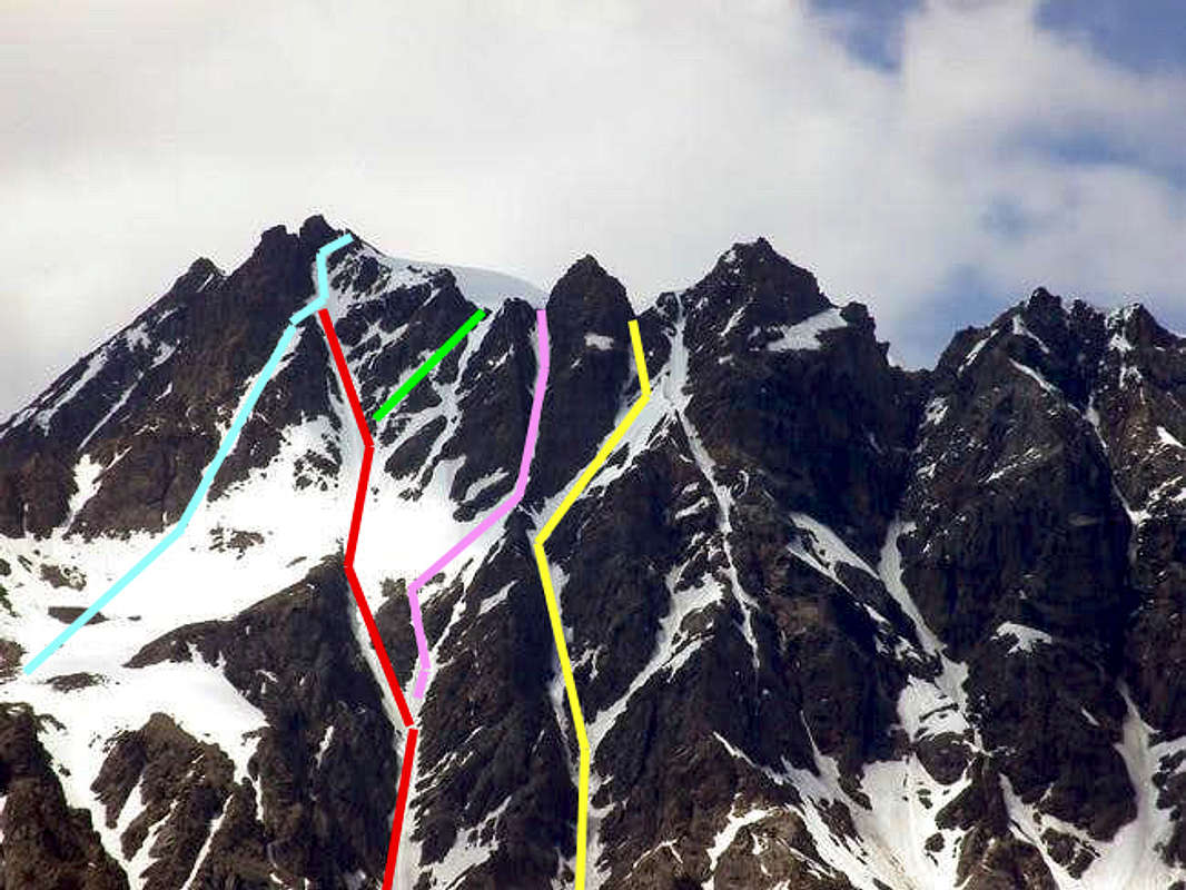
VELAN 's & HORNS 's Southwestern Crest, Couloirs & Western PillarLeft or West (Faceballa Saddle): Variant 1970, "Diagonal Via" 1976, Great Couloir 1890, various small variants from & to Minihorn/Brokenhorn 1997, "Narrow Couloir" between West/Central Horns 1997
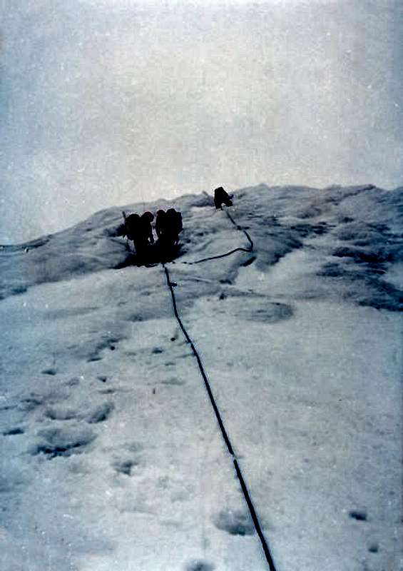
*From Sella di Faceballa South-southeast diagonal Gully and South-southeast great Couloir or "Diagonal Route" to the West Triple Brèche: Osvaldo Cardellina, "Gigi" Gadin and Faustin Savoye, Jul. 15th, 1976; with diagonal ascent, below Quota 3.650 meters; in day on South-southeast Face. Descent integral on East-northeast Crest towards Valsorey's Col. Next downhill on By's Basin to homonym alps. PD/PD+-, with brief various steps of I°/I°+/II/II°+ on rock with brief stretchs in snow (35°/40°/42°); in ascent to Quota 3.650 meters from Faceballa Saddle(2.880m)2h'00/2h'15(see even just above). * More Western Great Couloir of Southeastern Face: Ellis Carr, William Martin Conway, F.M. Devies with swiss Mountain Guides Hulrich Kaufmann and Joseph Marie Lochmatter, August 16th, 1890, with first crossing North/South through descent to Comba Berruard. These in descent; in ascent with a stretch of progressive steep (35°/40°/42°/46°) and up to the 50° in a stretch narrowing near the Sella di Faceballa. Note during the first traverse of Mont Velan: after a short stretch of a quarter of an hour on the Southwest Crest immediately after the departure from the Quota3.650 meters. PD-/PD/PD+; 3h'30/4h'00 from the base to Velan 's Summit; 5h'00'/5h'30; from Rosazza at Savoie Bivouac(2.679m), 5h'00/5h'30; Glacier or Glassier Hamlet (1.562m)7h'00/7h'30; Champillon Parking(2.050m)7h'30'/8h'30. Danger of falling of stones and in any case it is quite inadvisable. With very "confusing descent" (many zigzags) into the great Southeastern Couloir to By's Basin 1h'30/2h'15. This canal is today also descended on skis. Quota 3.650 meters even from or to West Triple Brèche (3.628/30m~), amongst Quota 3.650 meters, Mini Horn and Broken Horn: * Carving between the double or bifid Broken Horn and Western Horn (Minihorn Central Triple Brèche (3.608m~): Osvaldo Cardellina, solo, July 18th, 1997; in ascent from Champillon plaine, through the long dirt road to the North and after bypassing Ansermin(2.070m), along the parallel "Ru de By", towards Econdu(2.137m), the nearby Praz du Champ and Faceballa Pastures(2.385m). Going up to the base in altitude of 2.803 meters at the entrance into the Southeast great Couloir; followed by descent in the first sector from the Eastern Triple Brèche (3.605m~), between Broken Horn and Mini Horn (just to the right by the first or at West and below the angular Quota 3.650 meters above the Faceballa Saddle); with the second part of the descent into the South-southeast or more Western great Couloir of the Southeastern Face, above the underlying Comba Berruard in By's Basin. Ascent, this, "exploratory" in view of climbing the next (July 18th, 1997) pillar next week or "Hourglass Pillar" directed to the Western Horn(3.620m). PD+/AD-, Particular long, challenging ascent (not so much due to technical difficulties), as in the subsequent descent phase, with brief various steps of I°/I°+/II°/II°+ on rock and degrees from 45° to 40°/35° in ice or snow. 3h'15/3h'30; from base to Carving; 4h'45/5h'15Rosazza at Savoie Bivouac(2.679m). Dangerous climbs (above all during the ascent phase) for the enough continuous falling of stones, it requires caution and continuous attention and vigilance, in ascent as in descent in highest part up to the connection into Southeastern Couloir to Comba Berruard. This itinerary is not yet repeated 1h'30/2h'15.
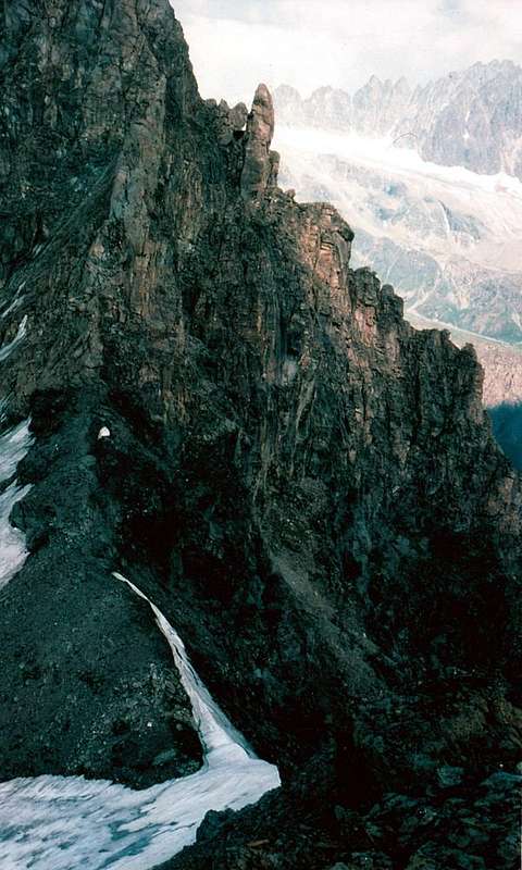
Summit Icy Cup after Diagonal Via on Southeast Wall, by "Faustin" Savoye
VELAN Southern Face HORNS's ROUTES from left (West and above (Comba Berruard/By Basin): * Southern Face West Horn (3.620m) on the "Hourglass Pillar": Osvaldo Cardellina, solo, July 25th, 1997, in ascent through the, with the said and baptized by me, "Hourglass Pillar"; always lone and in day. PD+/AD-/AD/AD-, with various steps of II°+/III°/III° on rock. 3h'30/4h'00 from the base to Velan's Summit; 5h'00/5h'30; from Rosazza at Savoie Bivouac(2.679m), 5h'00/5h'30; from Glacier also Glassier Hamlet (1.562m)7h'00/7h'30; from Champillon Parking into homoym plain (2.050m)7h'30/8h'30. Danger of falling of stones; this itinerary is not yet repeated and in any case it is rather inadvisable. *West Horn Western Brèche (3.610/2m~): Osvaldo Cardellina, lone, July 25th, 1997, in descent by and through the just adjacent "Narrow Gully/Couloir", always so called by me on occasion of the first climb. PD+/AD-, with various steps of II°+/III°/III°/III°+ on rock and degrees, in descent from 65°/60° to 40°/35 in ice or in snow. A glacial path, not at all easy, that climbs linearly with long diagonals alternating in the direction and that, about halfway along the route, overcomes a strip of rock on a rib that comes from the Eastern Velan Horn (3.618), to then come together at an altitude of about 2.930/50 meters with the "Hourglass Pillar" descending from the just adjacent and parallel Western Horn (3.620m). The same increases progressively in steepness up to the exit, which can become complicated in the presence of verglass on the terminal rocks, not often easy. This route requires, especially downhill, excellent snow settling and good ice experience. 2h'30/3h'00 from the Western Brèche to the base at 2.705/10 meters in altitude on Comba Berruard, always into the wide By's Basin; 5h'00/5h'30; from Rosazza at Savoie Bivouac(2.679m), 5h'00/5h'30; from Glacier also Glassier Hamlet (1.562m)7h'00/7h'30; from Champillon Parking(with wooden fountain supplied by the cold, underground V'lan's waters; 2.050m)7h'30/8h'30. Danger of falling of stones; this itinerary is not yet repeated and in any case it is rather inadvisable. * Eastern Horn (3.618m~) Southern Pillar: Osvaldo Cardellina, lone, September 27th, 1998, in ascent by with integral descent in day into the great Southeastern Couloir to Comba Berruard into By 's Basin. PD+/AD-/AD/AD-, with various steps of II°+/III°/III° on rock. 3h'30/4h'00 from the base in altitude of about 2.710/15 meters to Velan's Summit; 5h'00/5h'30; from Rosazza at Savoie Bivouac(2.679m), 5h'00/5h'30; from Glacier also small and isolated Glassier Hamlet (1.562m)7h'00/7h'30; from Champillon Parking(nearby a stone cross just after the just after the wooden fountain with Mont Velan's waters source; 2.050m)7h'30/8h'30. Long and dangerous climb due to the bad rock with often uneven and not stable handholds and footholds with subsequent relaiive danger of falling of stones; it also requires the ability to identify the route and link the various and numerous passages.The direction of ascent is dictated by three large Northeast-Northwest-Nortrheast zigzagging diagonals, the last of which departs from a clear "bottleneck" neighboring the "Narrow Couloir" at an altitude of around 3.475/85 meters. This itinerary is not yet repeated and in any case it is rather inadvisable, although surely it is more direct and very less dangerous than the via climbed on June 28th 1920, such as to force long crossings below Teeth and Horns. In the first ascent, descent into the Southeast Couloir to Comba Berruard 1h'30/2h'15.
VELAN 's RIDGES SPUR & PILLARSLeft or West: Hannibal 's Crest to Quota 3.678 meters and from Faceballa Saddle various routes on Southern Faces to Velan's Quota 3.650 meters, Western/Eastern Horns, Testa d'Ariondet & Mont Capucin
* West Horn Western Brèche (3.610/2m~): Antonio Frisoni, Cesare Negri, Luigi Vavassori and Carlo Virando, June 28th, 1920; leaving to the right or East the wide East-southeast faces of the Tête de Riondet also Testa d'Ariondet(3.485m), from base in altidude about 2.790/95 meters of the VI° or Velan's Little Tooth(in high just detached East-southeast; about 3.530/35 meters) or more Eastern Pillar, also called by me, "Angular Broken Double Southern Pillar", before by direct ascent for about 350/70 meters; after with progressive diagonal traverse to the left or West. Passing a first helved snowy or icy gully, below the "Hanging" Pillar followed by a second gully and crossing in the half the "Streched" Pillar, a second couloir below the five Teeth; after continuing with more steep ascent, always in diagonal, on the third or Central great Couloir (under V'lan's Teeth) and diagonal ascent on Eastern Horn(3.618m) reaching the Eastern Brèche between the same and the first from West or I°V'lan's Tooth (3.395m). Complicated and complexe climb combined with the following crossing always at the left or West on South Pillar of more Western Horn). For mountaineers much expert and good trained, but still anachronistic ascension and out of all logic.PD+/AD-, with various steps of II°+/III° on rock and degrees from 40° to 60° in ice or in snow. 4h'15 from the base to Velan's Top; 5h'15/0'30 from Rosazza at Savoie Bivouac(2.679m). According to the first climbers: unsafe holds and continuous falling of stones, also due to the exposure with a long crossing. It requires continuous vigilance, this itinerary is not yet repeated and in any case it is really inadvisable.
From Faceballa Saddle (left or West) Italian Southern Routes above Comba Berruard into the Conca di By up to the Valsorey 's Pass (3.107m)
South Face VELAN's TEETH, TESTA d'ARIONDET, MONT CAPUCIN, COL des CHAMOIS, MONT CORDINE ROUTES (from left or West to the right or East): * Teeth 's "Carving" or Jags's Saddle (3.557m~): Osvaldo Cardellina, solo, August 27th, 1995, with ascent in day and descent along the Southeastern great Couloir or route of August 1890 to Comba Berruard. PD+/AD-/AD/AD+, with some passages in rock of II°/II°+/III°-, in the midst and highest part and degrees from 35°/40° to 60°; in ice or in snow. 3h'00/3h'15 from the base to Velan's Top, with direct ascent into the couloir to the right or East in respect to "Hanging" Pillar, traverse right/left (East/West) on the same up to the third or Central Couloir (to the leftt or West in respect to "Hanging" Pillar) and by this to Teet 's Carving; 5h'00/5h'30 from Rosazza at Savoie Bivouac(2.679m). Requires continuous vigilance and very attentive caution; this itinerary is not yet repeated and in any case it is quite inadvisable. * Southeast Face under the Testa d'Ariondet, with deviation to trhe right or East-northeast towards the East-northeast Ridge or Italian Standard Route : Mario and Nunzia Borelli, 25 July 1916. From F to PD/PD+/AD-, with some steps of II°/II°+/III°-/III° on rock along the main rib descending from a little evident antesummit to the East . This ascension was made in 8h'00 for the first climbers from the base about 2.700 meters, near one small cross in altitude 2.663 meters around just above Faceballa Alp (2.385m), up to the Col du Capucin (3.376m); with ascent before to the East in respect to "Angular Broken Double Southern Pillar", after by direct climb for about 350 meters and new diagonal ascent in direction to the right up to the final difficult rocky jump below the Top. After giving up this last challenging stretch of the climb, the group of of roped climbers of 1920 continued at the end of their vertical line; the ascent finally continue with climbing in traverse again to the right or East, but almost horizontal via, reaching the enough large pass or Col du Capucin(3.376m), on East-northeast Ridge from Valsorey Pass. This via requires continuous vigilance and very precise caution; this itinerary is not yet repeated and in any case it is little advisable. Probably, by the base 4h'00/5h'00 from Rosazza at Savoie Bivouac(2.679m), 6h'00/6h'30, from Glassier Village (large parking near the Buthier Torrent; 1.549m) even 8h'30/9h'30 * South-southeast Slope of Mont Capucin towards the East-northeast Ridge : October 17th, 1912, Abbot Joseph-Maria Henry with guide Théodule Forclaz after an attemp into the "Couloir des Chamois". From F to PD/PD+/AD-/AD (?), from Rosazza at Savoie Bivouac(2.679m), with traverse to the West and, after the Torrent de Plan Bagò, oblique ascent on debris slope upto the end of couloir, often snowy, descending from Capucin Pass. Reached the Southeast rib after around 120/130 meters of climbing, to overcome a series of three gendarmes and by followed delicate steps directly to the Summit This ascension was made in 9h'00' for the first climbers from the base about 3.020/30 meters, just above Plan Bagò (2.436m) and starting from the last up to the Col des Chamois (3.259m); pratically direct ascent. * Through the Southeast Couloir of Col des Chamois (between the Combe de Berruà and middle sector of Valsorey's Glacier) and with first traverse on the East-northeast Ridge : September 26th, 1912, Abbot Joseph-Maria Henry with guide Théodule Forclaz. First known traverse: July 21th, 1902, C. Montandon, A. Moret, A. Niggli and R. Zeller, by probably route from North to South (Valsorey's Glacier/By's Basin). From F to PD/PD+/AD-, not a simple, instead dangerous and probably no longer traveled route since it had a unique exploratory sense; in fact the nearer and safer Colle di Valsorey (3.107m) is to be preferred. This ascension was made in a sole 3h'00 for the first climbers from the base about 3.020/30 meters, just above Plan Bagò (2.436m), up to the Col des Chamois (3.259m); with pratically direct ascent. *South-southeast Slope of Mont Cordine and East-northeast Ridge : August 17th, 1939, Giovanni Soncelli and Paride Tagliabue. Repeated by Ettore Castiglioni with a company at the end of August 1943. From F+ to PD-, from bivouac neighboring of Boégno Bà or Bas Pass(2.674m) to address him towards Northeast reaching after about one hour the base of the face in altitude 3.050/70 meters around; continue in the center of the same through brief rock jumps alternated with debris and dangerous slabs. After about 100/10 meters to cross to the right or East over a enough better rocks; then returning to the left or West through not easy slabs reaching a chimney and by this to Italian/Swiss border not far from the true Summit (3.329m). This ascent was made in more of 4h'00, by the first climbers on August of 1939.
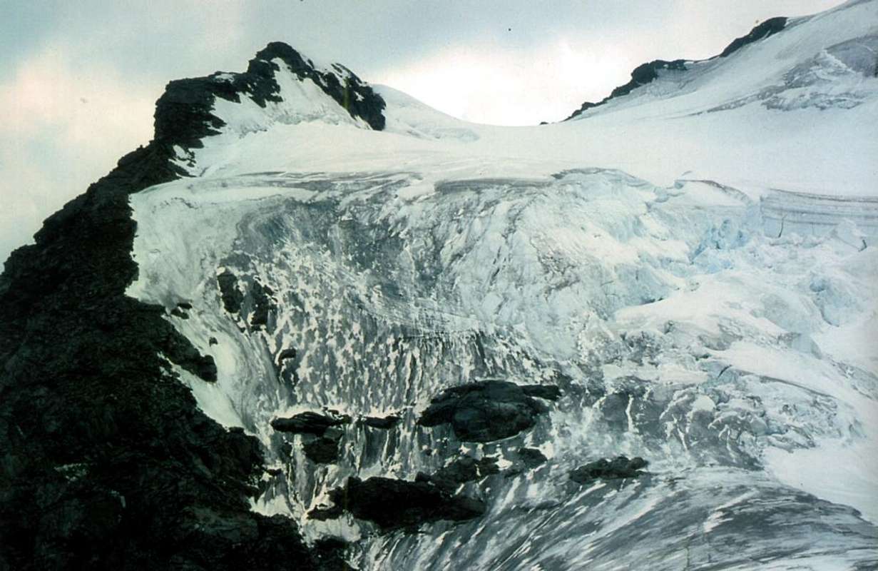
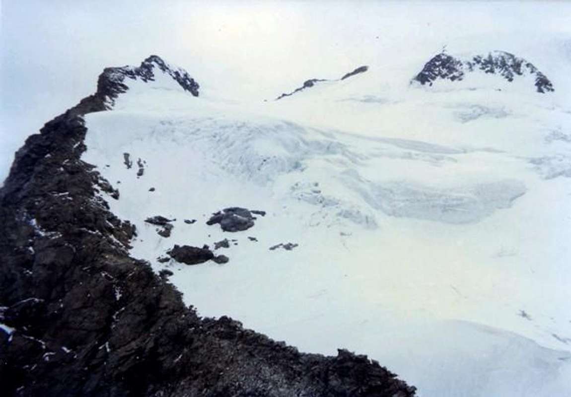
From Faceballa Saddle (in bottom from South in the first picture) in descent along the Italian Normal Route up to the Valsorey 's Pass (3.107m) 2h.45'/3h.15' from Valsorey Col; 4h.15'/4h.45'
* Italian Normal Via or East-northeast Ridge from Valsorey Pass (3.107m), with departure from Rosazza at Savoie Bivouac (2.651m) nearby the Boégno Bà or Bas Pass (2.674m) into By's Conca: the two Monks of Great Saint Bernard D'Allèves and Marquis on Summer 1826 (in occasion of the third absolute of mountain ascent), but with Swiss route and subsequent connection in the highest final part. From F+ to PD-, from bivouac in the neighbor of Boégno Bà or Bas Pass(2.674m) to address him towards Northeast along a small and not always evident trace (numbered in yellow with 3) that with a long diagonal in "light" ascent, overcoming some small vallons (in grass and debris with rare bolders) it brings him in direction of a small torrent that comes out of an area of large boulders in the midst of which you have to find the traces of the passage; exceeded the same, leave the bottom of the valley and climb to the left (West) up the steep scree slope that leads to the Valsorey Pass(3.107m, an unique and brief passage with delicate traverse on a rocky terrace from left right and just exposed with exit out through a little snowy frame, sometimes even three meters high). On a track, which often disappears, go up in the direction of achieving the same end of a broken route and debris immediately to his left; overcome it, taking care not to drop the stones on those who follow. Once up the hill to the right cross in the same direction, passing some small balconies with easy but exposed rocks; the frame of the hill, in general, it always passes to the left against the start of the Northeast Crest of Cordine. From the pass you do not continue with this, but, leaning to the right on a clear track, climb through the shattered Northeast Slope; progressively move, always following the trail on the ridge, reaching a shoulder snow at an altitude of 3.221 meters, called "Plateau de Cordine". Leaving on a rocky spur that goes right up to plunge into glacier through broken rocks and debris, but easily reach the Cordine's Top (3.329m)2h'00/2h'30.
Variants: a) - from the Plateau de Cordine (Cordine's, at the beginning rocky after snowy, Tableland, 3.221m), before starting the final ascent on the ridge, descend diagonally to the base of the small spur (very continuous and dangerous cracked area, because presents many crevasses) and then continue to the base of the North Face of Mont Cordine with almost flat path and, via away, with less and less crevasses until, after a short ascent, reach the Col des Chamois;
b) - continue on the border ridge until the ridge becomes steep towards the pass; at this point descend along broken and easy rocks and mixed with debris reaching the previous route on the glacier;
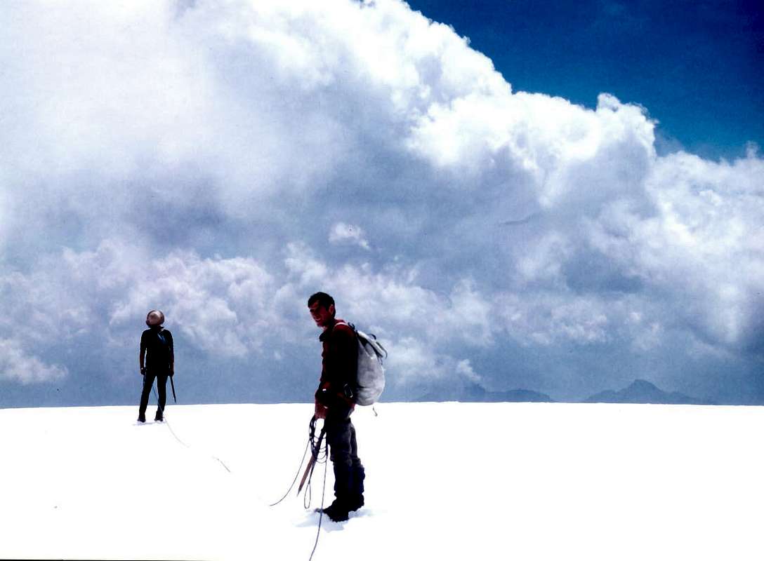
c) - before reaching the Cordine descend with a diagonal towards the Northwest on its small snowy Northern Wall (approximately 100/120 meters) rejoining the previous variants;
d) - from the Top of Mont Cordine(3.329m) continue on the edge of the ridge with brief and direct descent to Col des Chamois(3.259m) by a white fixed rope (exactly 70 meters, II°-/II°/II°+). From the col, or better narrow pass, continue on and along the Italian/Swiss border and go up the ridge which leads to the inclined to the South Doigt du Velan(V'lan 's Finger; 3.314m) through traces and passages of II°-/II° on enough solid plates and cracks (1 old nail with small cord). Always follow the ridge until you reach the rocks (II°) that lead to the Summit of Mont Capucin(3.395m). With route on small easy rocks and debris just at the limit of glacier reach the reddish Capucin and next homonym pass (3.376m, better with use of the rope); from this last to continue through brief stretch up to the crest, where it is more steep. After a brief but challancing icy passage (in verglass delicate step that require a solid safety), on the remains of an old serac, below the Testa d'Ariondet(3.485m) above a small icy wall (about 40/50 meters, with slope up to 45° and dangeraous ascent in presence of verglass). Skarting the same Testa d'Ariondet also Riondet just to the right to cross along the entire glacier, leaving left even the various V'lan's Teeth and the three Velan's Horns to go up along the highest part reaching in succession a little rounded and glacial "conca" (basin) preceding the just little emerging rocks of Quota 3672 meters and, with circular route to the North, the Ice Cup(3.734m). From Valsorey Col (3.107m)3h'15/3h'45; from Rosazza at Savoie Bivouac(2.679m)4h'15/4h'45; from By's Alps6h'00/6h'30; from Glacier Hamlet(1.549m). Important remark: sometimes this final glacial stretch requires, if in bad conditions with large open crevasses or in the presence of "verglass", to pass towards the adjacent South-southwestern Ridge that from the altitude 3.650 meters leads to the Summit, also just below the same with semi circular route. This tour on the left or orographic right is increasingly used, given the recent slow retreat of the glacier. From Valsorey Col (3.107m)3h'15/3h'45; from Rosazza at Savoie Bivouac(2.679m)4h'15/4h'45; from By's Alps (Porchère, 2.102m; Chesal, 2.039m; Seytives(2.088m); 6h'00/6h'30; from Glacier Hamlet(1.549m). * East-northeast Ridge or Standard Via with variant integral from and towards the Valsorey Pass (3107m): August 17th, 1975, Osvaldo Cardellina, Marco Cossard, Camillo Roberto Ferronato, Giuseppe Lamazzi and Roberto Meneghini in ascent and in descent (with, during the descent, by Osvaldo Cardellina, lone, the second absolute ascent of Doigt du Velan(Finger); 3.314m); in day from the Pastures of By's Conca; first entire and integral. Repeated by Osvaldo Cardellina, "Gigi" Gadin and Faustin Savoye, July 15th, 1976 second complete and integral, in descent, after the "Diagonal Gully" in ascent. From PD- to PD/PD+/AD-, same route but always remaining on the edge of the ridge along the entire Italian/Swiss border, then with ascent even of six V'lan's Teeth, three Horns, the next Broken Horn, Mini Horn up to the Quotas 3.650 and 3.672 meters, just preceding the Iice Cup (3.734m). From Rosazza at Savoie Bivouac (2.651m), nearby the Boégno Bà or Bas Pass (2.674m) into By 's Conca, in total from 7h'00 to 8h'00 in ascent; the half in descent, always with ascent of Testa d'Ariondet, Little Tooth and five Teeth, three Horns. Half an hour more for the ascent and subsequent descent on "Dente" del Velan.
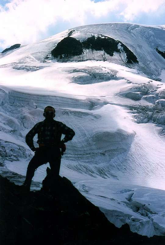
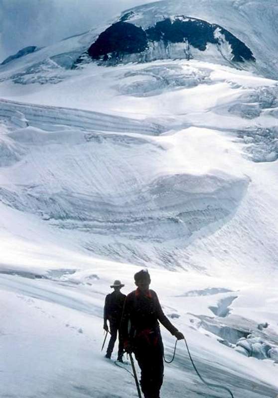
Descending on Valsorey Glacier nearby Testa d'Ariondet o Riondet (3.395m) towards Valsorey 's Col (3.107m)
DOUBLE CONNECTION between the Rosazza at Savoie Bivouac and the Cabane du Velan via Col de Valsorey, the homonymous glacier, Col de la Gouille and Glacier de Tseudet Logically there is also the possibility of connecting the two huts with departure from both Italy near Bivacco Rosazza-Savoie on Boègno Bàs(2.651m, 2.674m) through the Col di Valsorey(3.107m) and from Switzerland from the Cabane du Velan(2.659m), below Petit Velan(3.223m), and via the Col de la Gouille(3.149m) through the middle part of the Glacier de Valsorey and the entire Glacier de Tseudet, in its lower part. Reached the Col de Valsorey (yellow signs with small path numbered 3 and little cairns) do not go down directly on the Glacier de Valsorey (crevasses and danger of falling rocks) but go up towards Mont Cordine(3.229m) with the possibility of descending on it from its before rocky after snowy "Plateau de Cordine" (about 2.215/25 meters) through an easy snowy slope or with the variants from the above, therefore including the descent of 70 meters with fixed rope, ladders and chains to the underlying Col des Chamois(3.259m). From each of these points and with descent on a modest glacial slope, connect with the Swiss Normal Route(just below the islet that contains the upper seracs fall) and then continue to the Northwest with a modest ascent first and with a steeper descent after passing the lower "seraccata" of the Glacier de Valsorey. With a convex path on the right (West), go down along the basal rocks of the ridge that from Mont de la Gouille(3.212m) goes up towards the Arête of the same name with its various altitudes. Still following the left orographic edge of the glacier, go below the Col de la Gouille to less than 3.100 meters , identifying the area of ascent to the same by means of red signs; go up the small wall using fixed ropes 3h'00/3h'15 from the Rosazza-Savoie Bivouac, 2h'00'/2h'15 from the Colle di Valsorey). From the same, descend rapidly on the underlying Glacier de Tseudet and with a semi-circular route in the Northwest reach the base of the North-Eastern side of the Petit Velan; with a slightly steeper descent on the western edge of the glacier reach the Cabane du Velan (2.659m), located at the base of the Nordeast Edge of the same (1h'20/1h'30 from the col and 4h'30/5h'00 from the departure). For the reverse route, calculate 1h'00/1h'30 more' with the partial times of 2h'00/2h'30 at the Col de la Gouille and descent on the Glacier de Valsorey, 2h'00/2h'30 to Valsorey's Col and 'another hour' to reach the Rosazza at Savoie Bivouac. This crossing can also vary over time both for the conditions of the opposite two glaciers and for those of the weather's quality. In the absence of appropriate knowledge of the area, do not undertake with poor visibility. In any case, this crossing is almost never entirely not traveled, also because it is more logical to reach the two refuges from the respective valley bottom.
Difficulties
From PD-/PD with short stretches to PD+AD-/AD/AD+ for all the routes described above.
Da PD-/PD con brevi tratti di PD+/AD-/AD/AD+ per tutte le vie descritte.
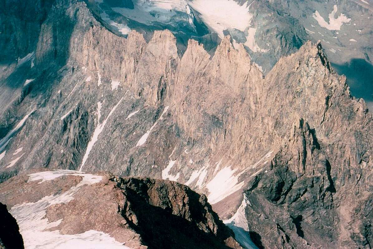
Italian Southern Routes on South-southeastern Face of Horns & Teeth, by Osw
Essential Gear
Rope, ice axe and crampons; helmet, carabiners, rock and ice nails for the more or less demanding or most challenging and difficult routes.
Corda, piccozza e ramponi; casco, moschettoni, chiodi da roccia e da ghiaccio per le vie più o meno impegnative oppure per quelle più difficili.
Mountain Conditions
You can get meteo information at the official site of the Regione Valle d'Aosta:


 2472 Hits
 79.04% Score
 10 Votes