
|
|
Mountain/Rock |
|---|---|
|
|
16.26741°S / 168.12172°E |
|
|
Hiking, Scrambling |
|
|
4377 ft / 1334 m |
|
|
Overview
Ambrym volcano consists of a large elevated caldera that covers a good portion of the island of Ambrym in Vanuatu in the South Pacific. The caldera contains a vast ash plain and several cones surrounded by lose ash and gravel hills and deep erosion channels. The two main cones are Benbow and Marum, which are often referred to as two separate volcanoes. Both have several active craters each. Benbow consists of a vast outer crater at its top, with an inner cone containing the active smaller craters inside. The active craters of Marum are more accessible and are located next to the cone. Both Benbow and Marum are known for their frequently visible active lava lakes, a very rare phenomenon throughout the world. Meltungon village on Ambrym island
Getting There
Getting to Ambrym island requires a bit of a journey, depending on where you come from. Port Vila, the capital of Vanuatu, is reached by plane from Australia, New Zealand, New Caledonia, and Fiji by several airlines. From Port Vila, Air Vanuatu flies to Ambrym twice a week (Tuesdays and Saturdays at the time of writing, but check the Air Vanuatu website for up-to-date information). Craig Cove airfield in Southwest Ambrym is the usual destination, but one can also trek from near the Ulei airfield in East Ambrym. For treks from North Ambrym, fly to Craig Cove and take a speedboat to Ranvetlam in the North. Arriving at Craig Cove airfield
Topography and Volcanic Activity
The volcanic activity at Ambrym volcano is the main reason to visit. The two centers of volcanic activity at Ambrym are Benbow and Marum with their various craters. Benbow (1159m) and Marum (1270m) are located in the western part of the Ambrym ash plain, which fills the ~100 sq km caldera. Ash plain is a bit of a misnomer, as the terrain is mostly level only in the southern part of the caldera; much of the remaining area is covered by lose ash and gravel hills and deep erosion channels formed by the frequent rain.Benbow consists of a massive outer crater, in the middle of which sits a smaller inner cone containing the two active craters. One of them regularly contains a lava lake. The bottom of the outer crater and hence also the inner cone can only be reached by roping down from the outer crater rim onto the first level. Marum is equally complex, but other than for Benbow, reaching its active craters does not require climbing the main cone. Marum's cone contains several terraces of older, mostly inactive craters and is breached to the Southeast. In the area of the breach lies its most active crater, Mbwelesu, which regularly contains an active lava lake. Adjacent to Mbwelesu are Niri Mbwelesu crater and a few hundred meters further the smaller Niri Mbwelesu Taten.
Activity at Ambrym volcano varies and ranges from degassing and lava lake activity confined to the interior of the craters to large, ash-rich eruptions and production of crop-damaging acid rain across the island.


Routes
There are several routes to access the ash plain. Once on the ash plain, there are also several options for accessing each of the craters.Ash Plain Access
The most commonly used access routes are from the South, West, and North, probably in that order. For each of these routes fly to Craig Cove airfield. Access from the South is quickest but also the most strenuous due to the steep approach. It is also possible to arrange to enter the ash plain via one route and leave via another. Access is also possible from the East of Ambrym. For this route fly to Ulei airfield.
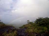 Looking back down the caldera rim to the South
Southern route
This route starts in one of the southern villages (Lalinda or Port Vato), from where a truck can take you part of the way inland. Plan on spending around 9000 Vatu return for the truck from Craig Cove (can be shared between several travelers). You then trek along a riverbed (lava sand), at times passing through the neighboring jungle for a few minutes to circumvent steeper rock faces. After about three hours of hiking, one reaches the caldera edge and commonly used campsite. It's about another hour from the campsite to either Benbow or Marum.
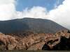
 Ash plain along Western access route
Western route
This route starts near the village of Meltungon in West Ambrym and again follows a dry riverbed/old lava flow. It is less steep than the southern approach, but takes up to six hours to reach the saddle between Benbow and Marum. From here it is a little less than an hour to either of the two cones. If you are only interested in seeing Benbow, it can also be climbed from the Northeast, in which case it's only about four hours to the base from Meltungon. Another half hour will get you up to the outer crater's edge. Return truck fare from Craig Cove to Meltungon is around 9000 Vatu.
Northern route
The Lonely Planet says it's six hours hiking from Ranvetlam, but I haven't done this route myself. If you have more details, please message me so that I can give you editing rights for this page. One important fact that needs to be mentioned here is that the Northern access route is closed every year from September 1 to January 31 to observe the yam-planting season in North Ambrym.
Eastern route
The Lonely Planet says it's four hours from Ulei to the ash plain, but I haven't done this route myself. Again, if you have more details, please message me so that I can give you editing rights for this page.
 Benbow crater
Benbow Access
Your route to the ash plain and your campsite determine the closest approach to the Benbow crater. The outer crater rim is lowest in the South, which makes for easy access. However, it is not possible to view the inner craters from this location. But due to the low height of the outer rim in the South, it is possible to descend by rope into the inner crater and walk over to the inner cone. The outer crater rim can also be accessed from the North East and East, and possibly other locations as well. The latter two access points offer better views onto the inner craters than the South rim.
Marum Access
The best access route for Marum depends on which crater(s) one wishes to see. To see all three active craters, one can approach from the West, starting just South of the saddle between the Benbow and Marum cones. After passing over or by the small 1988/89 eruption cones and lava flows one reaches Mbwelesu Niri Taten collapse crater, the smallest of the three, yet emitting impressive amounts of steam. Another ten minutes walk and scramble is the edge of Mbwelesu Niri, another but larger side crater of Marum. Carefully traversing this crater's edge counterclockwise for no more than half an hour takes one to a small plain next to the Mbwelesu crater. Given decent weather and not too much steam from the crater, it is possible to view the vent, and if present, the lava lake, from here. From here it is also possible to view the inner walls of the breached Marum cone and its old central craters and terraces. The crater edge can be further traversed to the right for different viewing angles. Mbwelesu crater can also be reached from a more easterly direction without passing Mbwelesu Niri Taten and Mbwelesu Niri.


Camping
Camping is possible just about anywhere on the ash plain. However, drinking water can be an issue. While it rains a lot (a LOT) on the ash plain, depending on your location and the wind direction the rain water may be highly acidic due to the sulfur dioxide emissions from the active craters. If the wind blows from you camp site towards the craters and activity is not higher than usual, the rainwater should be drinkable. The usual campsite used by guides from South Ambrym is at the South edge of the caldera where the surrounding vegetation transitions into the barren ash plain. Besides some protection from the weather, this camp site also offers a spring for water supplies. When choosing your own camp site, keep in mind the often high winds and strong rain during night and avoid pitching your tent in a rainwater runoff channel. Given a sturdy tent, it is possible to camp right on the edge of Marum's Mbwelesu crater as there is a small plain right next to the crater. A light sleeping bag will be enough to keep you warm at night (if you managed to keep the frequent torrential rain showers out of the tent). Camping on the ash plain
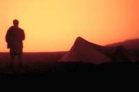 Camping next to Mbwelesu crater rim with lava glow
Red Tape
By Vanuatu's Kastom law, most land is owned by somebody. This also goes for the access routes to the Ambrym ash plain. It is the chiefs of the closest villages who control access. As a foreign visitor, you pay a fee of usually around 1500 Vatu, depending on your length of stay on the ash plain. This fee is part of what you owe for guides, and the final price should be negotiated before the trek begins. A guide is required and may help with carrying supplies for longer stays. A guide is also extremely useful for navigation, as a new visitor would almost certainly get lost on the ash plain, which in parts is not so much a plain as it is a maze of endless ash hills, dunes, and erosion channels. Guides usually charge around 2000 Vatu per day.When To Go
Being a tropical island, Ambrym's climate is warm year-round. It can get a bit chilly in the elevated caldera at night. It is often quite windy on the ash plain. The months around August are a little drier than the rest of the year, but up on the ash plain it can rain even when the sun is shining a few kilometers further down on the coast. If low-hanging clouds and rain don't obstruct the views into the craters and onto the lava lakes, the craters themselves often produce enough steam to steal the views. Patience is the key - plan a few days on the ash plain to increase your chances of good weather and visibility and take a raincoat for the inevitable rain showers.External Links
Ambrym Volcano page of the Global Volcanism Program of the Smithsonian InstitutionAir Vanuatu website
Currency conversion