
-
 4340 Hits
-
 83.69% Score
-
 17 Votes
|
|
Route |
|---|---|
|
|
45.94830°N / 7.00669°E |
|
|
Trad Climbing |
|
|
Summer |
|
|
Half a day |
|
|
5.7 (YDS) |
|
|
UIAA V+ |
|
|
7 |
|
|
Overview
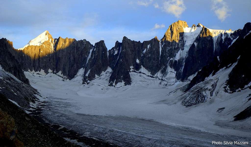
Arête du Génépi (Arête Sud)
Aiguille du Génépi 3059 m is a rock peak belonging to the satellites of Aiguille d’Argentière, a group located just in front of the incredible mountain scenery given by the North faces of the famous triptych Triolet, Courtes and Droites. On Aiguille du Génépi, built with the excellent red protogyn granite of Mont Blanc and located right above the Refuge d’Argentière, it runs an advisable classical route that follows the Southern edge of the peak in a setting of incomparable beauty: the Arète Sud, best known as Arête du Genepì.
Getting There
Road access
The base to climb is Refuge d’Argentière m. 2771, which can be attained starting from the village of Argentière m. 1240 (8 km. North-East to Chamonix-Mont Blanc) Main road access to Argentière are:
- From Valle d'Aosta (Italy) Follow the E25 Motorway towards Courmayeur, enter the Mont Blanc Tunnel to Chamonix, here turn to right to Argentière (73 km. from Aosta)
- From Martigny (Switzerland)
Follow the road getting the Switzerland – France border, then to the village of Argentière (37 km. from Martigny, 5 km. from the border).
- From Geneve (Switzerland) Follow the E25 Motorway to St. Gervais les Bains, then the RN 205 to Chamonix and Argentière


Approach to Refuge d’Argentière m. 2771
Reach the parking of Grands Montets cable-car in the village of Argentière. From here there are two possibilities to reach the Refuge d’Argentière, the starting point of all the climbs on the satellites of Aiguille d’Argentière:
A - Take the Grands Montets cable-car to the Lognan middle station m. 1973. From here follow an unpaved road, then the trail getting the orographic left side moraine (the right hand side by walking)of Glacier d’Argentière. Walk on the moraine as far as the height of 2250 m., lightly descent on a track getting the flat start of the glacier, follow the glacier, then again the track on the moraine as far as a system of iron stairways climbing the slabs on the right of the glacier. Climb the stairways to the summit of the moraine. A good and panoramic path follows the moraine, ending at the junction between the Glacier d’Argentière and the Glacier des Rognons. Downclimb some granite blocks (yellow marks) to get the flat surface of the Glacier d’Argentière, walking at first on the right side (by walking), then in the middle, finally traversing to the left side to take a good path leading to the hut. Longer but easier approach. From 3,30 to 4 hours from the Cable-Car station.
B - Take the Grands Montets cable car to the upper station of Grands Montets m. 3297. From the station walk down on the Glacier des Rognons, getting to the blocks (yellow marks) near the junction between this glacier and the Glacier d’Argentière. From here as for the previous approach. From 2 to 2,30 hours from the Cable-car upper station.

Route Description

Arête du Génépi report
Summit altitude: 3059 m
Difficulty: French 5b max, UIAA V+
Equipment: a few pegs
Climbing length: 250 m
Exposure: South
First ascent: H. Biondi, P. Darlot and R. Ravanel 1977, September 2nd
Starting point: Refuge d’Argentière m 2771
Arête du Génépi is a magnificent trad climb of about 250 meters running on a high quality reddish granite. This route is the classic of the sector, pleasing and varied, on a spectacular high mountain walls. There are few pegs in place, but it's easy enough to put in appropriate fast protections to integrate.
Approach - Behind the refuge head to North East (towards the moraine of the Amethyst glacier) following the waterpipe. Up the slope without reaching the moraine, but following a left directed trail between the blocks heading towards the obvious reddish wall (20 minutes from the shelter).The route starts on the edge to the left, just under a small triangular roof.


L1 - Climb directly the crack, slightly slanting right, skirt the small roof to the right (V +), then continue along the next crack to a comfortable belay on a ledge.
L2 - Traverse left 6 meters, turn an edge and then climb a crack (V) and belay on a terrace under a roof.
L3 - 2m shift to the right and then straight over (to the right of the overhang)and on easier ground reach a ledge. Belay on the ledge, V.


L4 - From the ledge climb up to the right without obliged route to a terrace, just below a vertical slab cut by beautiful cracks, III.
L5 - Climb straightly the beautiful crack (optional stop halfway) and belay on a ledge, V
L6 - From the ledge continue further along the ridge, pass a slab with two parallel cracks, leading on the summit of a block, where a light descent allows crossing on the other side
L7 - With some up and down is reached the true summit, IV, IV+

Descent - A 25 meters abseil North direction leads to a rocky notch, from where downclimbing easily along some rocky steps Améthystes side it's possible reach the base of the tower, then the start of the route.
Essential Gear
Rope 2x50 m, helmet, slings, small and medium nuts, some small friends, 10 quickdraws. A complete glacier gear is needed to approach Refuge d’Argentiere.
Red Tape

There are no restrictions in climbing and mountaineering.
When to climb

Best season goes from the end of June to the middle of September. The sunny East face of Aiguille du Génépi is a classic destination also in winter time, approaching it by ski and obviously with the correct winter gear.
Hut

Refuge d’Argentière m. 2771 - C.A.F (French Alpine Club)
Situation: Mont Blanc group - South West shore of Glacier d'Argentière
Open: from February to May and from June to September
Size: 150 persons + 30 in the winter-shelter
Getting There: from the village of Argentière by the Grands Montets cable-car to Lognan station (middle station) or to Grand Montets station (upper station)
Hut's phone : +330450531692
Accomodation in Chamonix
Chamonix is a primary mountaineering destination, offering several accomodations (hotels, huts, gites, renting rooms). Different campsites are situated both in the Northern and Southern ends of the town.
Main campsites:
- Camping la Mer de Glace - Les Praz (3 km. North to Chamonix) +33(0)450534403
- Camping les Deux Glaciers - Les Bossons (3 km. South to Chamonix) +33(0)450531584
- Camping les Arolles - close to the centre of Chamonix - +33(0)450531430
- Camping les Cimes - Les Bossons (3 km. South to Chamonix) +33(0)450535893
- Camping Glacier d'Argentière - Argentière (8 km. North to Chamonix) +33(0)450541736
- Camping les Marmottes - +33(0)450536124
Useful info
Office du Tourisme de Chamonix - Phone +33 0450 530024
Office de la Haute Montagne de Chamonix - Phone +33 0450 532208
Compagnie du MontBlanc Cable-car informations Phone +33 0450 532275
Guidebooks and Maps


- Guidebooks
"Monte Bianco classico & Plaisir" by Marco Romelli – Idea Montagna Editoria e Alpinismo
"6a max Savoie and Haute-Savoie" by Philippe Brass and Guillaume Vallot – Oros Ed.
- Maps
IGN 3630OT Chamonix - Massif du Mont Blanc Swisstopo 1344 Col de Balme Swisstopo 282 Martigny Swisstopo 46 Val de Bagnes
Meteo
Meteo Chamonix
MeteoSwitzerland