
|
|
Mountain/Rock |
|---|---|
|
|
36.13525°N / 114.5589°W |
|
|
Mojave |
|
|
3376 ft / 1029 m |
|
|
Background
But for a twist of fate, Arch Mountain would be very accessible -- too accessible. The gap between Arch Mountain and Guardian Peak was planned as the site for a huge dam ; i.e. the structure now known as Hoover Dam. If the original plans had gone through, there would be a big road right by the mountain.In fact, the 1926 USGS map – while failing to identify any nearby peak with a name – designates this passage as the “Boulder Canyon Dam site”.
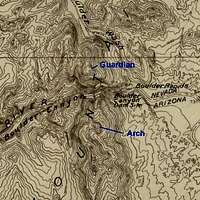 1926 Site for "Boulder Canyon Dam" 1926 Site for "Boulder Canyon Dam" |
Even though the actual dam was built eight miles away in Black Canyon, the name “Boulder Canyon Dam” stuck, with the original proposed location almost lost to history.
Ironically, the filling of Lake Mead, behind Hoover Dam, had made the peak more isolated. Before the dam, one could walk or take rough roads along the Colorado River, right to the base of the mountain. Now, the closest overland approach still gives a rough 15-mile RT hike. Some options for cutting the distance are discussed at the end of this entry.
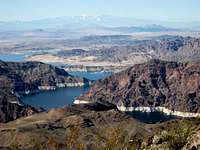
The best places to view Arch Mountain are in Nevada, across the Narrows of Lake Mead. From that position, the mountain looks very close, but very hard to reach.
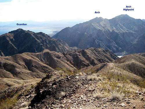 Arch Mountain from Nevada (Boulder Peak) Arch Mountain from Nevada (Boulder Peak) |
We found absolutely no beta on this mountain on the web, and know just two people (Nick N and Desert Danny) who had completed the trip more than 5 years ago. Hence we felt the SP entry was justified.
Geology
The mountain range is primarily composed of Miocene age Wilson Ridge intrusives (Twr, pink on the map below), from granites to basaltic dikes. However, you may cross several bands of Proterozoic gneisses en route. In fact, the very summit of “true” Arch, as well as the highpoint, are composed of the very old Proterozoic rocks (Xu, hornblende-biotite-plagioclase/quartz gneisses, gray on the map below). The nasty knife edge is mainly Twr. Both Twr and Xu tend to weather brown, so unless you see a broken surface, you may never spot the transition in the field. The Twr is a hodge-podge of smooth-weathering and brittle, jagged rocks.
 Geologic Map for Area Geologic Map for Area |
Near the shore, you will cross Quaternary and late Tertiary sedimentary rocks, most notably gypsum-rich banks (Toag, brown on the map above). The gypsum-rich rocks are quite pretty in places; there are some sparkly whitish rocks composed of rather large selenite crystals. The “dirtier” gypsum rocks are often carved into fantastic shapes, and there are high caves in the rocks that serve as homes to ravens.
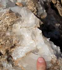 Selenite Gypsum Crystals Selenite Gypsum Crystals |  Pack of Gypsum Animals Pack of Gypsum Animals |
Wildlife
There are lots of burros and bighorns in this area.
 Bighorns en Route to Arch Bighorns en Route to Arch |  Burros en Route to Arch Burros en Route to Arch |
Near the ridge, I saw some very big carnivore scats, composed mainly of hair; possibly they were from a coyote, but I would guess: mountain lion. There are many mountain lions in the area; the Arizona wildlife authorities wanted to kill up to 10, to cut down on bighorn predation.
What about the Arch?
No arch is visible from this route. I suspect that if the arch exists, it is visible in The Narrows of Lake Mead; that is the place where most people view Arch Mountain.
Getting There
The usual approach is via the Temple Bar Road to Bonelli Landing. From us93 on the east (AZ) side of Hoover Dam, travel SSW toward Kingman. The road crests a pass at 15-15.5 miles and begins a long gradual downhill grade. At ~18.6 miles from the east side of the dam (by milepost 19), take a signed left (east) onto the Temple Bar Road. The first part of the road is paved, up to 13.4 miles; at this point the paved road turns sharply right to Temple Bar. You DO NOT want to turn; you want to keep straight, on the good gravel road for Bonelli Landing. Though the gravel road is generally bladed, there are a few washouts (Jan 26/08) that will get your attention if you insist on going above 30 mph. Follow the signs to Bonelli Landing, essentially driving straight to the shore of Lake Mead; the end of the road is ~20.5 miles from the turn at us93. The road goes substantially farther NE than when the USGS map was made (because the lake has receded a lot), so a GPS may show you travelling underwater at some point. Park as close to the shore as your car will take you – but stay off the soft sand, or you may be in for a nasty surprise when you try to leave at the end of the day.The entire road trip could be done in a normal passenger car as of Jan 26/2008, but HC would be preferred, and AWD or 4WD will be very helpful if you stray onto the soft sand. A shovel and board would be helpful in the latter contingency.
The Hike
There are two summits of interest. The first is the "true" or USGS Arch Mountain, which is named on the USGS map; it is 3376' in elevation. The second, to the south, is the highpoint of the ridge and is 3763' in elevation. There are lots of lumps in between.The Long, Sure-fire Loop (for Both Peaks)
I (MoapaPk) will describe the route taken by CP and me over both peaks, since I know this route works, but I’m absolutely sure there are better ways for the ascent of the “true” (named on the USGS map) Arch Mountain. The last part of the route – the descent – was suggested by Henry and Anya Jingle and is an excellent choice for coming off the highpoint, if your car is back at Bonelli Landing. Here is a GPS (gpx format) file for the full route, as described. (Use the gpx file at your own risk! If you download the file in Windows, you may wish to right-click on the link and use "save target...")
 100k Topo Map 100k Topo Map |  24k Topo Map 24k Topo Map |
After parking at Bonelli Landing, head WNW and NW, as straight as you can on the old beach, across Teakettle Bay. Eventually you will hit the gypsum headland on the N side of the bay; if you choose to stay near the water, you will end up following a convoluted path W and WSW on the N side of the headland, often walking high above the water.
 Shore Walk Shore Walk |  More Shore Walk More Shore Walk |
Eventually escape the ravines, and head NW toward the point labeled 676T on the USGS map. Cross a ravine and climb N to mount the ridge that runs E from 676T. Follow the ridge ~W up to a point just S of point 958T; nothing is much worse than class 2.
Surprise! Near 985T, you will have to turn ~SW, and descend a bit, before you can climb W to the main ridge, just N of the Black 1086.0 benchmark. Sit down, eat some salty food, and look N. You are now about halfway between the Arch range highpoint (to the S), and the true Arch mountain, which is about 1 mile away and to the N. The ridge is the obvious route to the true Arch; how hard could that be?
 Snowy Charleston from Ridge Snowy Charleston from Ridge |  Nasty Part of Ridge Nasty Part of Ridge |
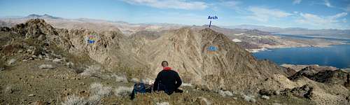 Panorama North from Ridge; Twr and Xu Units Shown Panorama North from Ridge; Twr and Xu Units Shown |
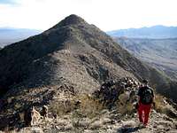
Well, the ridge is a little more interesting than you might expect. There are several knife-edged connections between the peaklets; that alone is not a deterrent. But the rocks that make up the knife edges tend to move around and wobble, which is a little disconcerting. At the end of one wobbley stretch, we decided to descend a little and head for the pass just E of the 967T point on the map.
 Fisrt Knife Edge Fisrt Knife Edge |  Second Knife Edge Second Knife Edge |
From that saddle, it is a fairly straightforward hike E over a false summit, then to the highest “true” peak of Arch Mountain. There is a collapsed survey cairn on the peak, but we found no register.
 View SE from Summit "True" Arch View SE from Summit "True" Arch |
On the way back, we decided to forgo the crumbly knife edge, and stayed high, a bit to the E of the ridge, for a sidehill traverse on so-so talus. We then traveled along the ridge, to a register (placed in 2002) on point “Black 1086.0”, then continued S over another peak, finally reaching the highpoint (point 1147T on the USGS map).
 Approaching Highpoint from N Approaching Highpoint from N |  View NW from Highpoint View NW from Highpoint |
After leaving the highpoint, travel ~300-400 m due S, then ~SE downslope, then E, to point just W of 918T on the USGS map. Now follow the drainage ~SE, BUT look for the signs of a big dryfall up ahead in the drainage – a clear view out over the lake, with that sinking feeling that the bottom is about to fall out. Don’t wait for the bottom to fall out; instead, gain the ridge to the SE, and follow the ridge down ENE and E, till reaching a more gentle drainage. Follow the drainage out E to near the lake, then follow the lakeshore back to your car. Total distance will be about 17 miles, with nearly 5500’ accumulated elevation gain, since you went up and down so much in the pass and ravine crossings.
 View S of Highpoint View S of Highpoint | 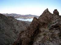 Deep Canyon at Left Deep Canyon at Left |
Alternatives
I’ve done none of these three, but all look promising.
1) Access from 4wd mine road
If one could drive up to the Cohenour Mine, the route to the highpoint, and the subsequent trip to the “true peak” and back, would be substantially shortened. There were register entries from the 1990s that gave the mine as the starting point for the highpoint hike. The turn for the mine road is approximately indicated in the GPS file, and should be at ~36.05688, -114.50809 (WGS84, decimal degrees). I didn’t check out this road at all, and cannot vouch for its condition. Please see this map.
There is a serious downside to this route. The ridge S of the highpoint is very rough, so there would be a lot of gratuitous elevation gain and loss.
2) Boat/canoe access
The best approach might be to put a canoe or kayak in at Bonelli Landing, then paddle 4 miles along the coast to a point directly opposite the east ridge of “true” Arch. From there one would travel roughly west up the east ridge. The east ridge looks rough and steep, but does not seem to have serious cliff bands. See the blue-dot hypothetical route in the 24k map above. You can actually rent a powerboat at Temple Bar (928-767-3211). The links section lists one place in Boulder City that will rent canoes or one- and two-person kayaks (please look for the rates that do not include tours, and make sure you have proper roof carriers and tie-down material if you choose this option).
A caution: Lake Mead varies a lot in the condition of the water. There are no trees along the shore here, and the water can be peaceful, or quite choppy, depending on the wind. If you have ever paddled a keel-less kayak on a lake, you probably have a good idea what can happen in strong winds.
3) Be patient and continue the shore walk
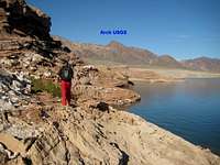
If we had continued for ~1 mile more up the shore – cutting back east and downhill after the gypsum cliffs – we probably could have angled NW, without undue pain, to the east ridge of “true” arch. The key is that after the gypsum cliffs and the circuitous trip around coves, the shore appears to become milder, at least above the first bench, as indicated in the photo from the top of Arch.
Update: on Feb 19/2008, Anya and Henry tried this route, as shown below. The acsent was pretty good, but the descent along the shore was tortuous and torturous.
 The east ridge route The east ridge route |
Camping, When, What to Bring
Camping
You can camp at Bonelli Landing – there are pit toilets a ways from the current shoreline, and several flat spots for primitive camping. You will need to bring all water. Perhaps this is the best way to make the hike feasible in the short days of winter – stay overnight and hit the “trail” by 6AM. Driving from Las Vegas, we got to the landing fairly late, and didn’t start till after 8:30AM; when we got back to the car, at 5:30PM, it was fairly dark with no moon. You can do the last part of the hike in minimal light, provided you have a foolproof way of finding your car.
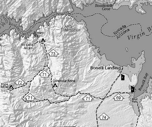 Camping and Roads near Arch Mt. Camping and Roads near Arch Mt. |
Or, you can camp at Temple Bar, in a real camping area, with running water, a restaurant, and pay showers.
Red Tape
None as far as I know; obey the standard rules for traveling or camping on BLM land. There are no fees to enter this area.
When
Unless you have a severe death wish, do this hike only in cool weather. Usually, that would be between early November and March; but I’ve seen sufficiently cool days as late as June, and miserably hot days in January for Lake Mead. The lakeshore gets to 120F in summer. Check the weather before you go, and don't go if it will be above 75F in Las Vegas that day.
Essential Gear
--Water! Lots of it, and some salty snacks.
--If crossing the knife edges, at least 50’ rope or webbing, 1-2 10’ slings.
--Headlamp! This is a long rough hike for the shorter cool days of winter, early spring, or fall.
...and of course, the 10.13 essentials.
Links
USGS publications center Search for “Preliminary Geologic Map of the Lake Mead” (without quotes)Anya's and Henry's hike to the highpoint
Boat rental in Boulder City
Plans to hunt mountain lions in AZ Lake Mead
Temple Bar-Bonelli NPS map as of July, 2007
The NPS changes its map location URLs, so you may have to use a search engine for: "temple bar area" maps "lake mead".