
-
 58827 Hits
-
 96.11% Score
-
 57 Votes
|
|
Area/Range |
|---|---|
|
|
46.59000°N / 11.83000°E |
|
|
9925 ft / 3025 m |
|
|
Overview
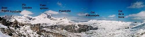
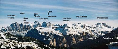 Overview of Puez Geisler / Odle Group from Sella Pass |
The Puez-Geisler Group is the northwestern outpost of the Dolomites against the Eisack- and Villnöß-Valleys. It is best known for the impressive north faces of the Geisler summits to its west and the solitary standing Peitlerkofel / Sass da Putia to the east. Lesser known and thus much less frequented are the plains and valleys of the Puez Plateau which nevertheless offer some of the best hiking routes of the whole Dolomites.
This page defines the Puez Geisler Group along the boundary of the natural park that carries the same name. To the north it reaches towards Villnöß- / Val di Funes and Aferer Valley , to the east towards Campill- and Gadertal (Alta Badia). To the south Grödner Joch / Passo Gardena and the ramp downwards to Kolfuschg / Colfosco and Corvarra are the boundary whereas to the west it reaches almost down to the Eisack-Valley.
For the purpose of clarity the group will be further divided here into the following groups/supgroups:
Much of the information on this page has been compiled with the help of two absolutely excellent books by E.E. Striebitz. The information is in the appropriate section below.
Getting There
  |
As there are three valleys from which you can access the group, here there are the principal itinaries:
- Villnöß / Val di Funes - Afers
Take the Brenner Motorway (A22) to Feldthurns (Valturno) and go east on Sp27 into Villnößtal (Val di Funes) or SP29 into Aferer Valley. - Gröden / Val Gardena
Take the Brenner motorway A22 to the exit of Waidbruck (Ponte Gardena). Turn onto S242 east either to St. Ulrich (Ortisei) or St. Christina. - Gadertal / Alta Badia
- From Belluno:
Drive along the S.P. 1 provincial road as far as Ponte nelle Alpi, turn into the S.S. 51 as far as Castello Lavazzo, and the 51 bis as far as Vodo di Cadore, in Pierosa enter the S.S. 48 to Andraz and eventually continue along the S.S. 244 to Corvara and the other localities of the Alta Badia. - From Venice and Treviso:
Drive along the A27 motorway to Belluno, exit Pian di Vedoia, turn into the S.S. 51 as far as Pierosa, and into the S.S. 48 as far as Andraz and eventually into the S.S. 244 to get to Corvara. - From Padova:
Drive along the A4 motorway, exit Mestre - Venice airport Marco Polo, and enter the A27 motorway, exit Pian di Vedoia. Continue to Corvara according to the directions from Belluno. - From Vicenza:
Drive along the A4 motorway, direction Brennero-Verona Nord, here enter the A22 motorway, via Verona, Trento and Bolzano, exit Bolzano Nord. Drive along the S.S. 12 as far as Waidbruck, and the S.S. 242 as far as Ortisei/St Ulrich and finally the S.S. 243 to get to Corvara. - From San Candido and Dobbiaco/Toblach:
Drive along the S.S. 49 as far as San Lorenzo di Sebato and then continue along the S.S. 244 to get to Alta Badia. - From Bruneck / Brunico:
Drive along the S.S. 242 to get to the localities of Alta Badia from Corvara to Colfosco/Kolfuschg
- From Belluno:
The Aferer Geiseln / Peitlerkofel Group
 |
Peitlerkofel / Sas da Putia and Aferer Geiseln / Odle di Eores form the northernmost outpost of the Dolomites. Together they form a west – east ridge which is set a little north-west of the Geisler / Odle Group.
Aferer Geiseln
The Aferer Geiseln are best known for the ferrata “Günther Messner Steig” which was named in honour of Reinhold Messners brother who died in an avalanche while descending from Nanga Parbat. The summits themselves offer little in terms of interesting climbs. The following descriptions are given from west to east:
- Col Magrei (2331m)
- Weißlahnspitze / Cima Lavina Bianca (2528m)
- Tullen (2652m), highest summit of Aferer Geiseln
- Wälscher Ring (2623m)
- Ringspitze (2531m)
- Zendleser Kofel / Col di Poma (2423m)
- Sobutsch (2485m)
- Medalges (2454m)
Peitlerkofel (2874m)
Isolated massive mountain with two summits. Normal route via ferrata from the south. Several interesting climbs through the north face.
See the SP Peitlerkofel / Sass da Putia page for more information.
The Geisler / Odle Group
 |
Together with Peitlerkofel the Geisler Group is the northwestern outpost of the Dolomites. Well known - from any Dolomite book or calendar are its famous north faces that drop for almost 1000m into the Villnöß valley (Val di Funes). The Group consists of a multitude of towers of almost all sizes that are topped by the two main summits of Sass Rigais and Furchetta which both reach the same height of 3025m (sometimes 3030m are claimed for Furchetta). Beside the peaks the famous passes and cuts between the subgroups and towers of the group make up part of its fascination.
The Geisler / Odle Group can be roughly divided in three parts. To the west there are a number of meadow summits which show steep rock faces to the west and north. Between Fermedaturm (La Peles) and Forca de Mesdi there is the Fermeda Group with a great number of fine spires and needles. To its eastern side the Geisler / Odle group consists of 6 massive towerlike summits between Sass Rigais and Wasserkofel (Sass da L’Ega).
All of the summits can be climbed. All normal ascends start from the southern (Gröden) side. The north faces almost all consist of fragile rock, so that they can become very dangerous. The only exception is the combination of Meraner Weg and Solleder Route through the north face of Furchetta.
When hiking in the area keep in mind that the north faces always carry snow and ice late in spring and even summer. Though you might not be aware of it when you start from the Gröden (Val Gardena) side you must account for slippery conditions. Moreover ice keeps falling off the summit blocks so that climbing and hiking through Forca Pana or Forca di Mesdi may become a quite dangerous affair (speaking out of experience).
The following descriptions are given west to east:
- Außerraschötz / Rasciesa di Fuori (2282m)
One of the greatest viewpoints summits between Gröden (Val Gardena) and Villnöß (Val di Funes), can be easily reached by cablecar and a 20min ascent. - Innerraschötz / Rasciesa di Dentro (2317m)
Broad meadow peak, also easily reachable from the Gröden side. - Seceda (2519m)
Cablecar station some 20min below the summit. From the southern side only a meadow summit, it’s northern and western faces, however, are quite impressive. There are no climbing routes since the rock is VERY lose. - Brogles Rotwand (2590m
Like Seceda a meadow summit from the south but an impressive overhanging north face. No routes through the north face.
Normal route: south (II) - Villnösser Rotwand (2590m)
Again an imposing north face which has probably never been climbed.
Normal route: south (II) - Fermedaturm /La Peles (2640m)
North face with very lose rock. Often climbed as part of the normal route to Kleine / Piccolo Fermeda.
Normal route: south (II) - Kleine / Piccolo Fermeda (2800m)
One of the most fascinating climbing summits of the whole Geissler / Odle Group. Has lots of routes and variants.
See the SP Kleine Fermeda page
Normal route: west (II)
First ascent: J. Santner 1884 - Große / Gran Fermeda (2873m)
The highest summit of the Fermeda Subgroup. It has a lot of climbing routes. Together with Kleine /Piccolo Fermeda the most popular summit of the whole group.
See the SP Grosse Fermeda page
Normal route: southwest (III)
First ascent: K. Schulz, E.T. Compton, T.G. Martin, M.Bettega 1987 - Villlnösser Turm / Campanile di Funes (2830m)
Very fragile rock, nevertheless many documented routes.
Normal route: east (III)
First ascent: L. Darmstädter, H. Stabeler, L. Bernhard 1889 - Odla di Cisles (2780m)
Very good climbing summit. Lots of routes.
Normal route: west (IV)
First ascent: unknown - Gran Odla (2832m)
Very fragile rock. Therefore rarely climbed.
Normal route: east (III)
First ascent: L. Darmstädter, H. Stabeler, L. Bernhard 1880 - Villnösser Odla /Odla di Funes (2800m)
Normal route: northeast (II)
First ascent: L. Darmstädter, H. Stabeler, L. Bernhard 1888 - Sass de Mesdi (2760m)
Great climbing summit with lots of routes.
Normal route: east (III)
First ascent: : L. Darmstädter, H. Stabeler, L. Bernhard 1888 - Sass Rigais (3025m)
Together with Furchetta the highest summit of the Puez-Geissler Group. Massive tower with very fragile rock. No interesting climbing routes but three ferrate.
See the SP Sass Rigais page
Normal route: west (II, but today a ferrata)
First ascent: B. Wahner, F. Niglutsch, G. Bernhard 1878 - Furchetta (3025m)
Twin summit (Furchetta, kl. Furchetta), exactly of the same altitude as Sass Rigais. Lots of climbing routes, especially through the north face.
See the SP Furchetta page
Normal route: west (III)
First ascent: J. Santner 1880 - Torkofel / Sasso della Porta (2964m)
Summit south of Odla di Valdussa. Fragile rock with lots of routes.
Normal route: north (III)
First ascent: L. Purtscheller, G.B. Vinatzer 1886 - Odla di Valdussa (2936m)
From the south an easy ascent. Imposing north face with a 700m drop.
Normal route: south
First ascent: unknown - Wasserkofel / Sass da l’Ega (2915m)
Fragile rock, rarely climbed.
Normal route: two routes from southwest (III and II)
First ascent: unknown
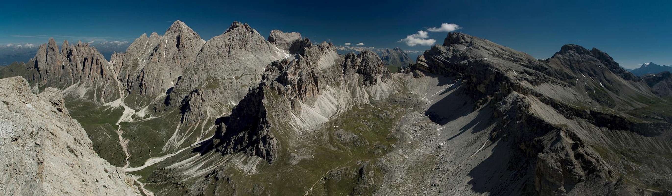
The Puez Group
 The Gherdenacia Plateau
The Puez Group consists of a large plateau at an elevation of about 2300m, the Gherdenacia Plain (see next section). Out of this plain rise several strange looking sandy hills, whereas all the major summits are located at the north and south edges. The plain is divided by two deep gorges, Langental (Vallunga), a beautiful glacier-formed valley and Val Chedul. Both valleys runs from east to west.
The most interesting summits are situated in the south: Cir towers, Sass da Ciampac and Sassongher. Here the Gherdenacia Plain drops down into the Colfosco valley. On its western side the Puez Group is terminated by the Stevia Subgroup, four smooth mountains, which can be climbed rather easily. To its north another deep drop into the Campill-Valley terminates the plateau. Here the summits (Piz Duledes, Puez Spitzen, Kapunzinerspitze an Zwischenkofel) show rather imposing north faces. To the east there is a sharp drop into Gadertal /Alta Badia with no major summits.
For the sake of organisation the group will be divided in four subgroups, which will be described in detail in the following sections:
- The Puez North Face
- The Gherdenacia and Crespeina Plateaus
- The Puez Southern Ranges
- The Stevia Subgroup
The Puez North Face
 |
This northern ridge of Puez prolongs the ridge of the Geisler / Odle Group. With the exception of Piz Duledes the northfaces are not as imposing as the Geisler ones. All summits can easily be reached from the Gherdenecia Plain in the south.
Descriptions from west to east:
- Piz Duledea (2909)
Piz Duledes can be reached from Forca Nives by a short Via Ferrata. There are several climbing routes along the west and north faces (up to IV) - Western Puezspitze / Punta del Puez Occidentale (2918m)
Hiking trail ascent. Very good views. - Eastern Puezspitze / Punta del Puez Orientale (2913m)
Hiking trail ascent. Very good views. See the Eastern Puezspitze page for more details. - Kapuzinerspitze (2710m)
Another hiking trail summit. Interesting north face route (V). - Ciampani (2663m)
- Col Toronn (2492m)
- Somamunt (2366m)
- Zwischenkofel / Punta delle Dodici (2471m)
Hiking trail 6A. Interesting route through the north face (III).
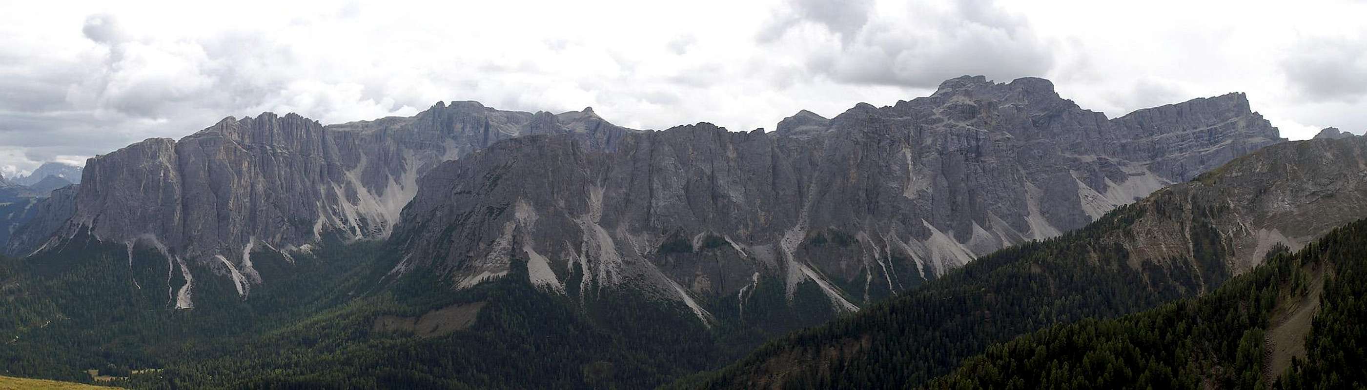
Gherdenacia and Crespeina Plateaus
 Southern view of the Puez Group
Text by Vid ;-)
Gherdenacia is a beautiful high plateau, taking a great part of Puez mountain group. Its beauty and karst nature are also the reasons that Puez-Geisler Group were declared a natural parc. Similar to the Gherdenacia Plateau is the much smaller Crespeina Plateau, which is located more towards south. The altitude of the plateaus varies between 2100m and 2500m, peaks above the plateau exceed 2600m. In early and late summer among broad limestone plates you can admire beautiful flat grass meadows filled with mountain flowers. Another specialty are a few strange sand hills, rising above the plateau. They are made of compact debris, in some places of weird colours unlike white limestone. The three most distinctive sand hills are: Col Puez (2725m), Col d'Muntejela (2676m) and Col de la Sone (2633m). On the lower part of the similar Crespeina plateau there is also a beautiful Crespeina Lake, attracting many hikers. The supporting huts for hikes over the Gherdenacia Plateau are Rif. Puez and Rif. Gherdenacia.
- Gherdenacia Plain
- Crespeina Plateau
- Puezkofel / Col del Puez (2725m)
- Col d'Muntejela (2676m)
- Col de la Sone (2634m)
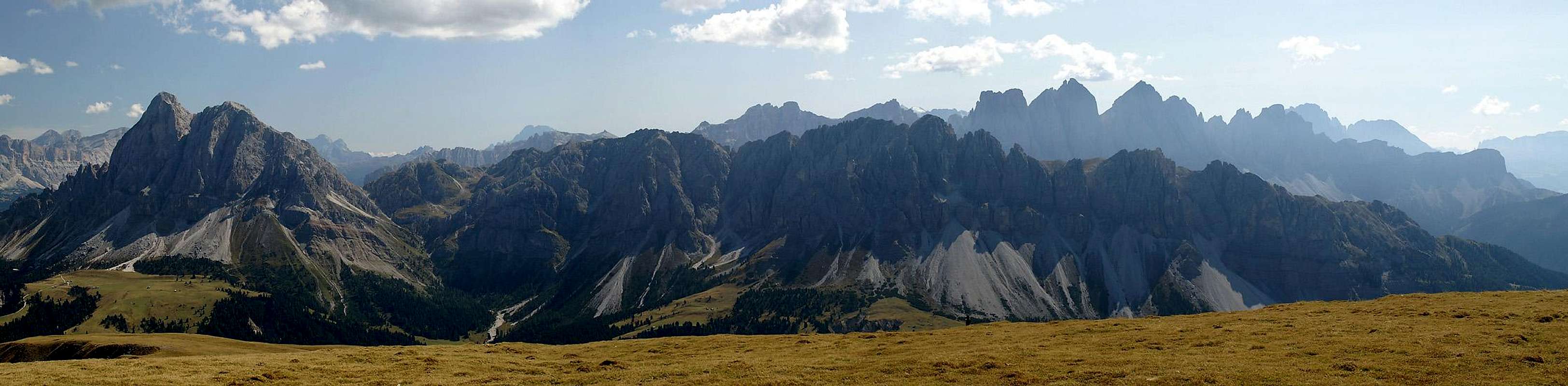
The Puez Southern Ranges
 The Stevia Group seen from Seceda
The southern summits form a line along the (west - east) ridge that towers over the valley between Grödner Joch / Passo Gardena and Corvarra. Only Sassongher to the east is located a little south of this ridge. All summits are climbing summits with quite a number of very interesting routes.
- Rotspitzen / Cuécenes (2368m)
Summit ridge a little northwest of Passo Gardena. There are six summits, which carry no names but are rather numbered from west to east. The first and third summits are the most interesting climbing destinations (both IV). - Cirspitzen / Pizes de Cir
Directly located to the east of Rotspitzen to the north of Passo Gardena. The twelve towers are very popular with climbers, especially since there is a ferrata to the highest of them.- Cir VIII: Ferrata with cables and ladders (II)
- Western Cir (2518m): Popular all year climb (III)
- Kleine / Piccolo Cir (2500m): Several routes (III and IV)
- Grosse / Gran Cir (2592m): Most popular climbing destination in the Puez Group. Ferrata along the normal route (I), several interesting difficult routes (most of them V)
See the Gran Cir / Grosse Cirspitze Page for more information. - Clarkspitze (2537m): Fragile rock , used for training purposes. Several routes (III – V)
- Eastern Cir (2583m): Also very popular with several routes (II – V)
- Col Toronn (2651m)
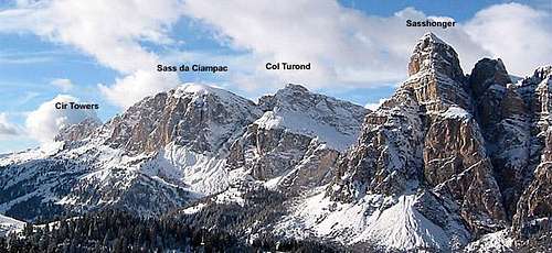
Broad Summit east of Cir Pass. The normal route is a normal hike (2h from Grödner Joch / Passo Gardena). There are several routes of all grades along the southern face (I – V). - Sass da Ciampac (2667m)
Summit with an easy normal route from Crespina Pass or Ciampac Pass. The south face is vertical and offers several routes in very good rock conditions. See the SP Sass da Ciampac page. - Col Turond (2418m)
Summit that towers south of Langental / Vallunga. Intersting north face with a couple of climbing routes (IV and V) - Sassongher (2665m)
One of the main Attractions of the town of Corvarra. There is a ferrata along the normal route and a multitude of other routes. Due to the fragile composition of the rock these climbing routes are not very popular.
See the SP Sassongher page
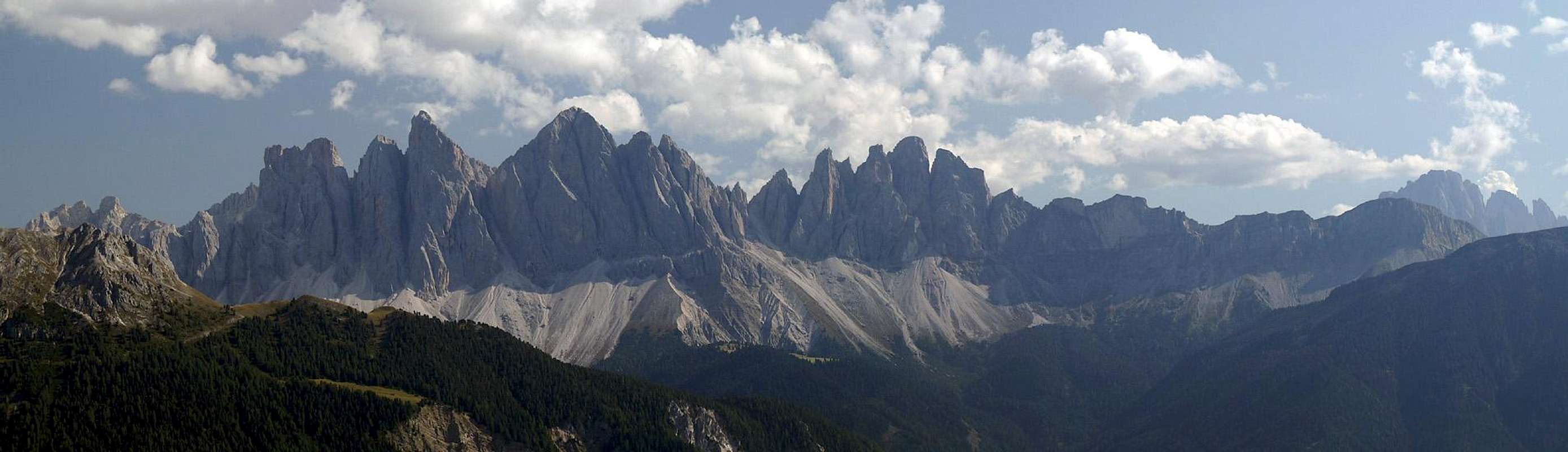
The Stevia Subgroup
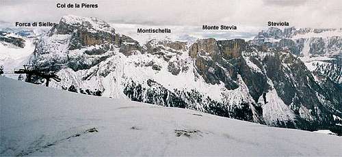
The Stevia Group seen from Seceda
Located between Langental (Vallunga) and the Geissler group to the latter’s southwest, the Stevia Group consists of four summits, which all have rather easy hiking ascents but also quite a number of serious and interesting climbing routes. On the top the summits are rather broad with fine meadows and offer fascinating views onto the Puez plateau as well as towards the whole western Dolomites. The Stevia group is a rather lonely region as compared with the other parts of the Puez-Geissler Natural Park.
The following descriptions are roughly from north to south.
- Col de la Pieres (2747m)
Highest summit of the Stevia Group. One of the finest viewpoint summits of the whole Alps. Easy hiking ascent from Wolkenstein / Selva di Gardena via Nadelscharte or Forca di Sielles. No climbing routes. - Montischella (2644m)
Reached from Nadelscharte (Forca di Piza) by a hiking trail. - Monte Stevia (2555m)
Main summit of the group. In its eastern part a high plateau with meadows. Imposing west face with quite a number of interesting climbing routes. Hiking ascent through Nadelscharte or Stevia Scharte. - Steviola (2139m)
Southwestern pillar of the Stevia group. Inteesting routes through the vertical walls. The new Via Ferrata Sandro Pertini climbs through the southern wall of Steviola.
Red Tape - The Natural Park Puez-Geisler
The Natural Park has been created in 1977 and contains an area of 10,703ha. Within park boundaries any building activities are prohibited. Flowers, berries, mushrooms, minerals have to be left in their environment. Camping is prohibited and cars have to be parked in the official lots.
For further information on the park, take a look ath the official website.
There are no fees or limitations for climbing, however you might have to be prepared for a small parking fees.
When To Climb
As with all Dolomite summits the best time is May through October but winter ascents are possible as well. Best time in my opinion is September or October since apartments are easily to be had and weather often is finest.
In winter there are a couple of very nice ski tours possible, especially on the Gherdenacia Plain and in Vilnöß / Val di Funes. Not to mention the downhill ski possibilities in Gröden / Val Gardena.
Hotels and Appartments
There are quite a lot of hotels and appartments to be had in the region around Puez-Geisler. In the summer months you most certainly will need reservations. Good entry points are the following pages:
Tourist Informations
The various tourist informations can be reached via
- Tourist Office Ortisei
I-39046 Ortisei - St. Ulrich - Str. Rezia 1
Tel.: +39 0471 796328
Fax: +39 0471 796749
e-mail: ortisei@valgardena.it - Tourist Office S. Cristina
I-39047 S. Cristina - St. Christina - Str. Chemun 9
Tel.: +39 0471 793046
Fax: +39 0471 793198
e-mail: s.cristina@valgardena.it - Tourist Office Val Gardena
Dr. Mussner Rudolf
I-39047 S. Cristina - St. Christina - Dursan 78/bis
Tel.: +39 0471 792277
Fax: +39 0471 792235
e-mail: info@valgardena.it - Tourist Office Selva Gardena
I-39048 Selva Gardena - Str. Mëisules 213
Tel.:: +39 0471 795122
Fax: +39 0471 794245
e-mail: selva@valgardena.it - Tourist Office Villnöß
I-39040 Val di Funes - S. Pietro 11
Tel.:+39 0472 840 180
Fax:+39 0472 841 515
Mail: info@vilnoess.com - Tourist Office Alta Badia
I-39033 Corvara - Col Alt, 36
Tel.: +39 0471 836176
Fax: +39 0471 836540
E-mail:
corvara@altabadia.org
lavilla@altabadia.org
laval@altabadia.org
Mountain Huts and Refuges
For mountain huts and refuges you can use the following
Gröden / Val Gardena
| Refuge | Tel. | open |
| Col Raiser | +39 0471 796302 | 06.06 - 12.10 |
| Cuca | +39 335 8060345 | 14.06 - 12.10 |
| Daniel | +39 333 6481163 | 06.06 - 12.10 |
| Fermeda | +39 338 7185720 | 21.06 - 12.10 |
| Firenze / Regensburgerhütte | +39 0471 796307 | 01.06 - 12.10 |
| Gamsblut | +39 338 8601244 | 31.05 - 12.10 |
| Juac | +39 335 8082321 | 12.07 - end Sept. |
| Mastlè | +39 339 8313483 | 06.06 - 12.10 |
| Pedrutsch | +39 0471 798093 | 01.05 - beg. Nov. |
| Ramitzler | +39 340 2420649 | 01.07 - beg. Nov. |
| Sangon | +39 339 5737568 | 20.06 - 20.10 |
Villnöß / Val di Funes
| Refuge | Tel. |
| Ristoro ed informazioni Zannes | +39 0472 840 309 |
| Pensione Sass Rigais | +39 0472 840 133 |
| Malga Zannes | +39 328 89 26 257 |
| Malga Dusler | +39 0472 840 501 |
| Nuova Malga di Casnago | +39 333 75 69 029 |
| Malga di Casnago | +39 0472 840 158 |
| Malga Glatsch | +39 0472 840 270 |
| Malga Gampen | +39 348 272 15 87 |
| Rifugio Genova | +39 0472 840 132 |
| Caseril | +39 0472 840 219 |
| Rifugio Halsl | +39 0472 521 267 |
| Ristoro Muntwiesen | +39 0472 840 043 |
| Malga Unterpiscoi | +39 0472 840519 |
Alta Badia / Gadertal
(the table includes refuges in other Dolomite Groups like Fanes and Sella)
| Refuge | Tel. |
| Corvarra | |
| Baita La Marmotta | +39 0471 836125 / +39 338 8801364 |
| Bec de Roces | +39 0436 79193 / +39 0436 79336 |
| Capanna Nera/Negerhütte | +39 0471 836138 |
| Cherz | +39 0436 79270 / +39 335 6175089 |
| Col Alto – G. Ferrante | +39 0471 836324 |
| Crep de Mont | +39 335 6023721 |
| F. Kostner - Vallon | +39 0471 836757 / +39 333 8759838 |
| Plan Boè | +39 0436 79339 |
| Ütia Ciablun | +39 0471 836633 |
| Ütia Punta Trieste | +39 0471 836643 |
| Kolfuschg / Colfosco | |
| Col Pradat | +39 0471 836188 / +39 338/9734662 |
| Edelweiß | +39 0471 836024 |
| F.Cavazza Pisciadù | +39 0471 836292 |
| Forcelles | +39 0471 836323 |
| Frara/Passo Gardena | +39 0471 795225 |
| Mesoles | +39 0471 836023 |
| Puez | +39 0471 795365 |
| La Villa | |
| Ciampai | +39 335 6943528 |
| La Fraina | +39 0471 836833 |
| Piz La Ila | +39 0471 847403 |
| Ütia de Bioch | +39 0471 847222 |
| Ütia de Trausines | +39 335 8036184 |
| San Cassiano | |
| La Brancia | +39 0471 836895 / +39 0471 847291 |
| Las Vegas | +39 0471 849355 / +39 335 7633756 |
| Pic Prè | +39 329 4369568 |
| Piz Sorega | +39 0471 849434 |
| Pralongiá | +39 0471 836072 |
| Scotoni | +39 0471 847330 |
| Ütia Saraghes | +39 380 5136865 |
| Pedraces | |
| Gardenacia | +39 0471 849282 |
| Lèe | +39 347 2383927 |
| S. Croce | +39 0471 839632 |
| Skihütte Nagler | +39 0471 839830 |
| Sponata | +39 0471 847847 |
| La Val | |
| Ranch da Andrè | +39 0471 843174 / +39 338 6098704 |
WeatherConditions
- South Tyrol weather information
As for Webcams (also weather) you can look at
Maps & Books
While hiking and climbing the group I have used quite an impressive number of books but only one map. All of them are in German, however. Any other language publications are welcome to me, please just add an additional info post.
Books
- Climbing
- Alpenvereinsführer Dolomiten: Geisler- und Steviagruppe
E. E. Striebitz
Rother Verlag
ISBN: 3 7633 1304 4 - Alpenvereinsführer Dolomiten: Puez / Peitlerkofel
E.E. Striebitz
Rother Verlag
ISBN: 3 7633 1307 9
- Alpenvereinsführer Dolomiten: Geisler- und Steviagruppe
- Vie Ferrate
- Klettersteige Dolomiten
H. Höfler, P. Werner
Rother Verlag
ISBN: 3 7633 3096 8 - Hülslers Klettersteigführer
E.E.Hülsler
Bruckmann Verlag
ISBN: 3 7654 4161 9
- Klettersteige Dolomiten
- Hiking and Trecking
- Höhenwege in den Dolomiten
H. Dumler
Bruckmann Verlag
ISBN: 3 7654 3860 X - Dolomiten 1
F. Hauleitner
Rother Verlag
ISBN: 3 7633 4248 6
- Höhenwege in den Dolomiten
Maps
I have been using the maps by Kompass Verlag. They are very good, the Puez-Geisler group is at the edges, however. Therefore I include three maps here (all 1:50000):
- Sellagruppe / Gruppo di Sella
Kompass Map WK 59
ISBN: 3 8549 1066 5 - Brixen / Bressanone
Kompass Map WK 56
ISBN: 3 8549 1063 0 - Cortina d'Ampezzo
Kompass Map WK 55
ISBN: 3-85491-062-2