-
 82843 Hits
-
 99.23% Score
-
 102 Votes
|
|
Area/Range |
|---|---|
|
|
46.43020°N / 11.85610°E |
|
|
10967 ft / 3343 m |
|
|
Overview
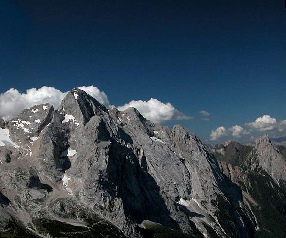
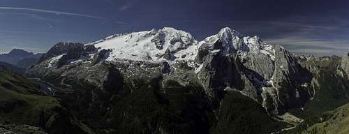 The central Marmolada Group seen from Sas Capel on the Padon Chain |
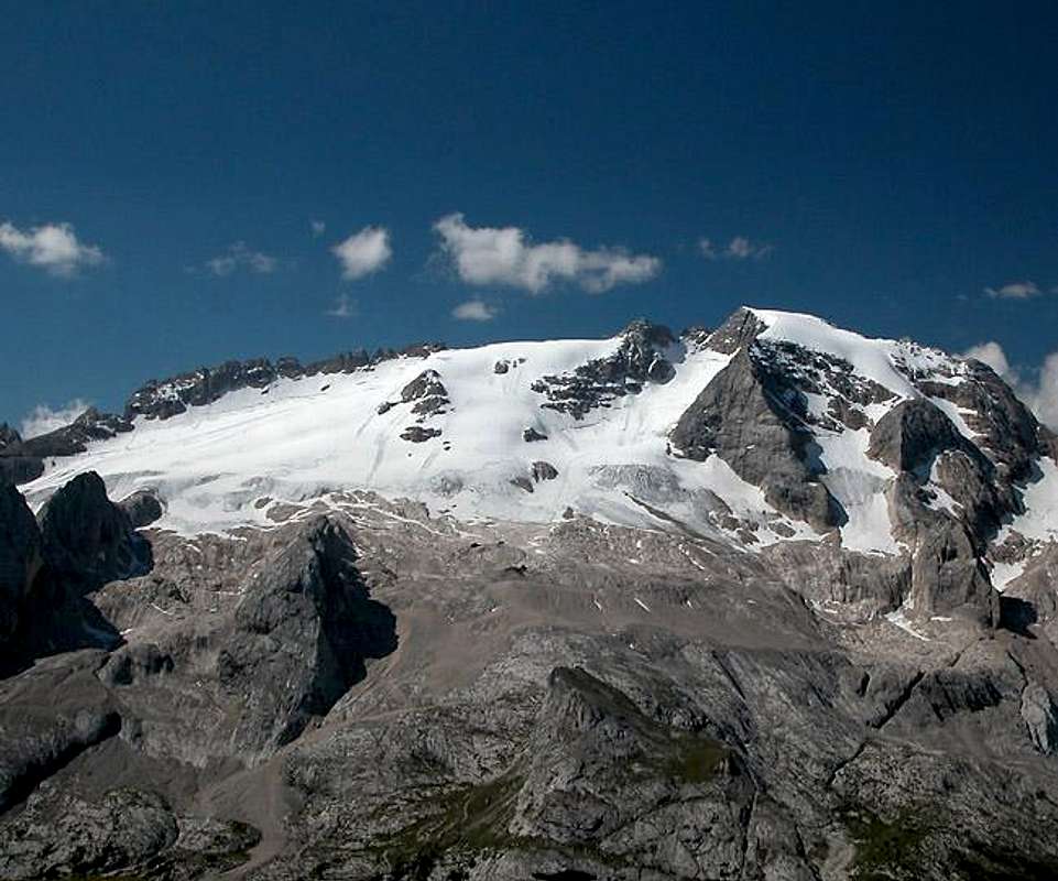
Marmolada – Queen of the Dolomites! Naturally everyone who has travelled the region knows its highest mountain. Located nearly at the centre of the Dolomites both its summits – Punta Penia and Punta Rocca – are higher than any other Dolomite mountain. Antelao, second highest one, (a.k.a King of the Dolomites) “only” reaches 3262m. What most travellers don’t see, however – probably blinded by Maromolada’s great white glacier – is that the Queen is surrounded by some of the region’s highest and most impressive summits.
The group surrounding Marmolada is one of the largest and most complex ones. In complexity it can be compared to the Sexten or Cortina Dolomites. Geologically, however it is even much more diverse. While most of the Dolomites is composed by the rock that gave its name to the region – Dolomite, a special kind of limestone – here right at its centre we can find the volcanic lava ridges of the Padon Chain and the Colac/Buffaure Subgroup. The great contrasts between the black volcanic rock and the almost white dolomite formations – not to mention the large Marmolada Glacier – are among the most interesting features of the region.
The Marmolada Group is a very popular hiking region. Very interesting hiking routes (like Bindelweg /Viel di Pan) and ferrate crisscross the group. Some of the ferrate have been in use since the days of WWI, where the valleys between the Padon Chain and the Sella Group saw some of the fiercest fighting. There was a whole military city below the ice of the Marmolada Glacier and the top of neighbouring Col de Lana (northwest of the group) was blown off in a futile attempt by Italian pioneers to chase the Austrians off this strategically important mountain. Needless to say that the whole war resulted in nothing but loss of life. No ground gained, no ground lost for three and a half years of fierce fighting. Two cemeteries at Passo Pordoi (German/Austrian) and Col di Lana (Italian) still tell the story. For us modern climbers/hikers some of the old trails of WWI have been converted into ferrate, most of them rather difficult.
For overview purposes I have divided the Marmolada Group into eight subgroups (roughly following the division proposed by L.Visentini. Look at the following map to understand their respective locations as well as the location of the Marmolada group in the larger Dolomites context
- Padon Chain
- Marmolada Massif
- Colac – Buffaure Subgroup
- Ombretta / Ombrettola Subgroup
- Cime dell’Auta Chain
- Vallaccia Subgroup
- Monzoni Subgroup
- Costabella / Cima dell’Uomo Chain
Pala di VernelPunta CornatesGran VernelPiccolo VernelMont de LeiteMarmoladaCime OmbrettaSasso VernaleCima Ombrettola
 |
 |
Much has been said about Marmolada. The mountain has its own page on SP so if you want any specifics, look there. This page (the one you are reading) is meant to put the Dolomite’s highest mountain into the context of the surrounding subgroup as well as the other Dolomite groups. Being located at the centre, it is neighbour to the following groups (starting clockwise from the south, see the map above)
- Pale di San Martino (south)
- Latemar (southwest)
- Rosengarten / Catinaccio (west)
- Langkofel / Sasso Lungo Group (northwest
- Sella Group (north)
- Cortina Dolomites (northeast)
- Monte Pelmo (east)
- Civetta (east)
The group is located at the border between the provinces of Trento and Belluno.
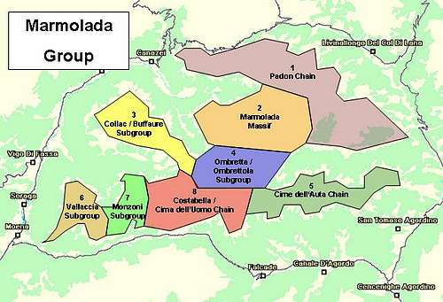 Overview Map of the Marmolada Group. The subgroups are indicated in different colours
1 - Padon Chain
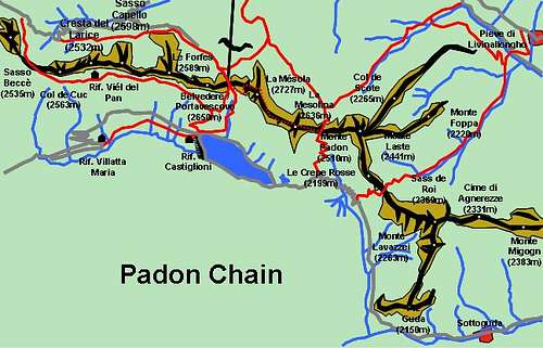
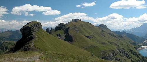
The Padon Chain is long single ridge which runs from west to east and turns south at Monte Padon. There are several side ridges east of Monte Padon. From a geological point of view the whole Padon chain has nothing to do with the Dolomites that surround it. It consists of black lava rocks and thus offers a stark contrast to the Sella Group to its north and Marmolada to its south. It contains a very difficult ferrata, the “Via Ferrata delle Trincée” which is located between Belvedere and La Mésola. The ferrata – like so many in the region – runs along the WWI front and follows the old Austrian positions. In addition there is the panoramic “Bindelweg / Viel di Pan” which starts at Passo Pordoi and crosses the Padon chain near Sasso Beccè and follows the slopes on the southern side of the ridge.
 Padon Chain
The summits are listed from west to east. The eastern side ridges are listed from north to south. Compare the map for reference.Main Ridge
- Sasso Beccè (2535m)
![]()
- Col da Cuch (2563m)
![]()
- Cresta del Larice (2532m)
- Sasso Capello (2598m)
![]()
- Col de Pausa (2415m)
![]()
- Le Forfes (2589m)
![]()
- Belvedere / Portavescovo (2650m)
![]()
- La Mésola (2727m)
![]()
- La Mesolina (2636m)
![]()
- Monte Padon (2510m)
![]()
Northern Side Ridge - Col de Scote (2265m)
- Monte Laste (2441m)
- Monte Foppa (2220m)
Central Side Ridge - Le Crepe Rosse (2199m)
- Sass de Roi (2369m)
- Cime di Agnerezze (2331m)
- Monte Migogn (2383m)
Southern Side Ridge - Monte Lavazzei (2263m)
- Piz Guda (2150m)


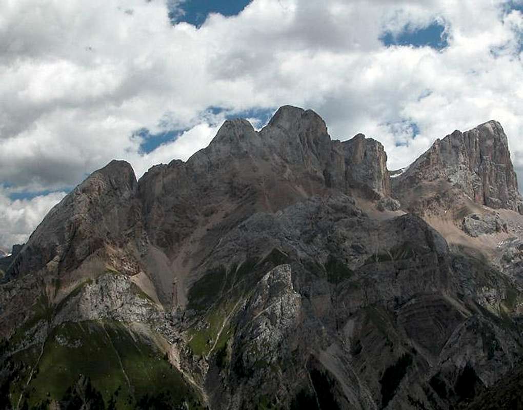
2 - Marmolada Massif
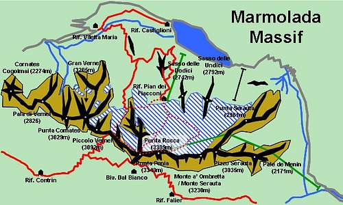
This is the centre of the whole Dolomites. With both summits, Punta Rocca and Punta Penia, Marmolada is the highest mountain of the region. Moreover almost all summits of this central ridge of the Marmolada Massif are higher than 3000m, only the summits at either end falling below that mark. Along the western ridge there is the oldest ferrata of the Dolomites (founded in 1903!!), the so called “Hans Seyfert Weg”. It is a long ferrata which ends at Punta Penia. Due to sudden weather changes the ferrata – which contains a LOT of iron cables, ladders and bolts – can become VERY dangerous, especially during thunderstorms.
Sasso da
le DoudesPizzo SerautaSasso da le UndesPunta RoccaPunta PeniaMarmoladaPiccolo VernelSass de la CiauresGran VernelRoda di MulonPunta CornatesPala diVernelColac
le DoudesPizzo SerautaSasso da le UndesPunta RoccaPunta PeniaMarmoladaPiccolo VernelSass de la CiauresGran VernelRoda di MulonPunta CornatesPala diVernelColac
 |
 |
The summits are listed from west to east.
Main Ridge
- Cornates Cogolmai (2274m)
- Pala di Vernel (2826)
![]()
- Punta Cornates (3029m)
![]()
- Gran Vernel (3205m)
![]()
- Piccolo Vernel (3092m)
![]()
- Marmolada / Punta Penia (3343m)
![]()
- Marmolada / Punta Rocca (3309m)
![]()
- Marmolada / Punta Ombretta (3247m)
![]()
- Monte a’Ombretta / Monte Serauta (3230m)
- Punta Serauta (2961m)
![]()
- Pizzo Serauta (3035m)
![]()
- Pale de Menin (2171m)
![]()


3 - Colac / Buffaure Subgroup
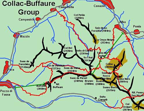
Located between Val di Fassa in the west, Val di San Nicolo in the south and Val di Contrin in the northeast this is one of the most popular hiking destinations in the Marmolada Group. The summits reach an average height of some 2500m and offer great views towards the eastern Dolomites (Rosengarten / Catinaccio and Latemar). There are a great number of rifugios and a cable car up to the main ridge at 2500m which adds to the popularity of the region. On the western end another cable car heads up to Buffaure. Like the Padon chain this part of the group geologically does not belong to the Dolomites since it is also formed by black lava. There are three western ridges which combine at Su L’Aut to form a single ridge eastward towards the last summit, Col Ombert.
 Latemar and Rosengarten / Catinaccio as seen across the Buffaure Ridge
The summits are listed west to east with the side ridges north to south. Look at the map for reference.
Northern Side Ridge
- Col Pelòs (2205m)
- Spiz de so Forcella (2484m)
- La Crepa Neigra (2534m)
![]()
Central Side Ridge - Sass de Peredatec (2143m)
- Col Bel (2436m)
- Sella di Ciamol (2361m)
- Su l’Aut (2513m)
Southern Side Ridge - Buffaure (2050m)
- Col de Valvacin (2372m)
- Sass de Dama (2434m)
![]()
- Sass de Porcel (2401m)
Colac Ridge - Colac (2684m)
![]()
- Torre Dantone (2524m)
![]()
- Sasso Nero (2601m)
Main Ridge - Brunec (2486m)
- Roseal (2480m)
![]()
- Sas de Roces (2618m)
![]()
- Croda Nera (2605m)
![]()
- Sasso Bianco (2575m)
- Col Ombert (2670m)
![]()
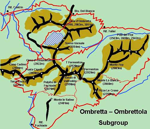
4 - Ombretta / Ombrettola Subgroup
![Handmade schematic map of the...]()
This subgroup is located directly south of the Marmolada Massif and consequently offers the best views on the huge Marmolada south face. It is a typical Dolomite Group, composed of numerous summits along a great variety of ridges. All of these ridges run towards Cima d’Ombrettola which is located roughly at the centre of this subgroup.
The summits are listed from north to south, starting at Passo Ombretta.
Northern Ridge- Cime d’Ombretta (2998, 2983m, 3011m)
![]()
- Sasso Vernale (3054m)
![]()
Main Ridge (west to east) - Cime Cadine (2886m)
![]()
- Torre Enrica (2775m)
![]()
- Punta Cigolè (2808m)
![]()
Main Ridge (west to east) - Cima d’Ombrettola (2922m)
![]()
- Sasso di Valfredda (2998m)
![]()
- Torre Formenton (2920m)
- Punta Formenton (2929m)
![]()
- Monte La Banca (2860m)
![]()
- Monte Fop (2883m)
- Pale del Fop (2563m, 2600m, 2562m) Southern Side Ridges
- Pulpito di Fuchiade (2875m)
- Monte le Saline (2401m)
- Pizzo Le Crene (2756m)
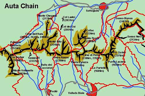
5 - Cime dell’Auta Chain
![Handmade schematic map of the...]()
Like the Padon Chain, the Cime dell ‘Auta chain is a long ridgeline running west to east. It is located between the Franzedas, Pettorina and Cordevole Valleys, southeast of the Marmolada Massif. The ridge starts at “La Forca Rossa near Pizzo le Crene in the Ombretta / Ombrettola Subgroup. Several side ridges leave the main ridgeline both to the north and south. A ferrata, the “Via ferrata Paolin – Piccolin” runs between the Cime dell’Auta.
The summits are listed west to east.
Main ridge- Col Becher (2444m)
- Punta di Barbaciu (2524m)
- Cime dell’Auta (2609m, 2622m, 2490m)
![]()
- Crepa Rossa (2360m)
- Punta Palazza (2160m)
- Cime di Pezza (2386m, 2394m)
- Piz Zorlet (2376m)
- Sasso Bianco (2407m)
- Sasso Nero (2134m)
Southern Side Ridges - Monte Vallesella (2020m)
- Sassedel (2337m)
- Punta Lazzera (1870m)
- Le Portelle (1689m)
Northern Side Ridges - Monte Alto (2545m)
- Monte Chegaris (2170m)
- Col dei Gai (2051m)
- Col Lastei (2037m)
- Monte Pezza (2405m)
![]()
- Colac (2236m)
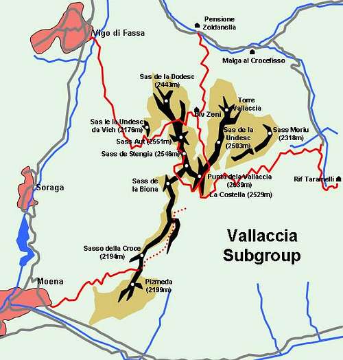
6 - Vallaccia Subgroup
![Hand made schematic map of...]()
Named after a couloir, which runs high up to Punta Vallaccia this group is the south-western outpost of the Marmolada Group. It shows some very impressive mountain faces, comparable to the neighbouring Latemar- or the northern Geisler / Odle Groups. The curved ridgeline clearly shows the origins of the mountains – atolls in the Mesozoic Thethys-Sea. Vallaccia has its own page so see there for more information.
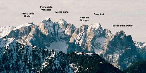
![Overview over the Vallaccia...]() Vallaccia Supgroup as seen from the Sella Plateau
Vallaccia Supgroup as seen from the Sella Plateau
Again the summits are listed west to east.
- Sas da le Dodesc (2443m)
![]()
- Sas da le Undesc da Vich (2176m)
- Sas Aut (2551m)
![]()
- Sas de Stengia (2546m)
- Sas de la Luna (2431m)
![]()
- Punta della Vallaccia (2639m)
![]()
- Sas da le Undesc (2503m)
![]()
- Torre Vallaccia (2514m)
- Sas da le Undesc (2503m)
![]()
- Sass Moriu (2318m)
- Sasso della Croce (2194m)
- Pizmeda (2199m)
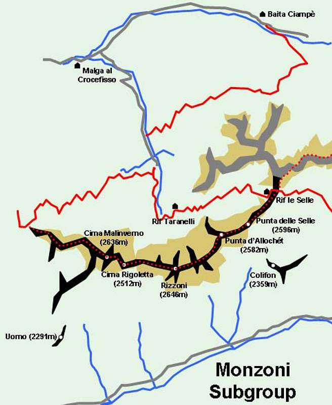
7 - Monzoni Subgroup
![Hand made schematic map of...]()
The Monzoni Subgroup is located further east between Vallaccia and the Costabella / Uomo Subgroup. It is a single ridgline composed of a multitude of different rock types (flintstone, porphyry, dolomite, basalt). Except for its endpoints it is rarely visited though a ferrata, the Alta Via Bruno Federspiel follows the ridge. The ferrata and itsaccess routes are very long which ensures solitude on the ridge.
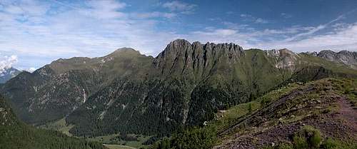
![Monzoni Ridge as seen from...]() Monzoni Ridge as seen from the Cima Iuribrutto Summit
Monzoni Ridge as seen from the Cima Iuribrutto Summit
Summits are listed west to east.
Monzoni Ridge- Cima Malinverno (2636m)
![]()
- Cima Rigoletta (2512m)
- Rizzoni (2646m)
![]()
- Colifon (2359m)
- Punta d’Allochét (2582m)
![]()
- Punta delle Selle (2596m)
![]()
- Uomo (2291m)
8 - Costabella / Cima dell’Uomo Chain
![Hand made schematic map of...]()
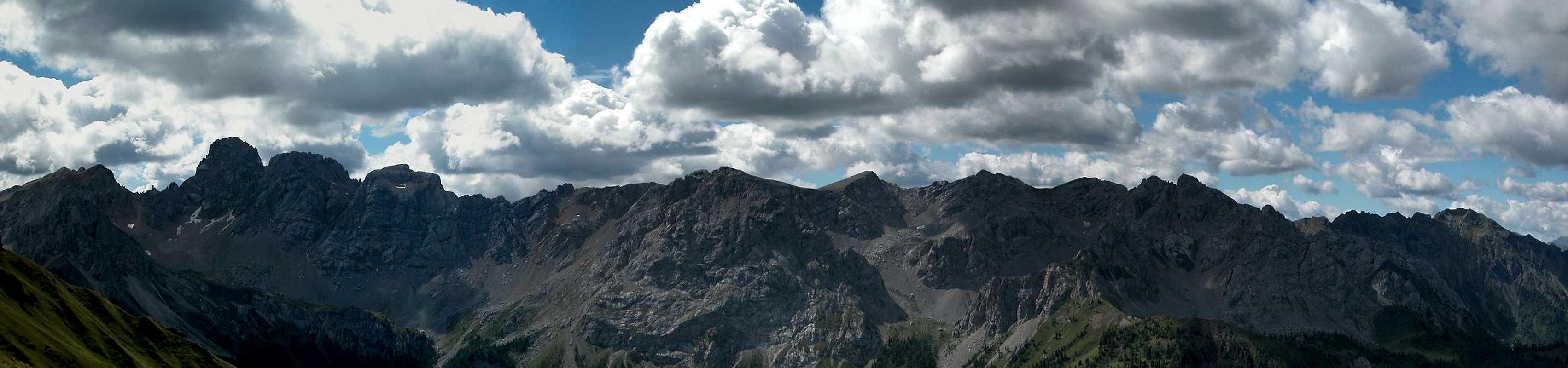
This is a ridge between Passo delle Selle and Forcella Tasca which separates the chain from the Obretta / Ombrettola Subgroup. A great part of the ridge can be climbed using the “Via Ferrata Bepe Zac”. The southern slopes are quite popular in wintertime since Passo San Pellegrino, which is located to the south provides a number of ski lifts. The eastern part around Cima dell’Uomo, which is the highest part of the subgroup, again is rarely climbed.![]() The Costabella Chain as seen from Sas de Adam
The Costabella Chain as seen from Sas de Adam![Enlarge]()
The summits are listed west to east.Main Ridge
- Pale di Carpella (2411m, 2430m, 2490m)
![]()
- Punta dell’Ort (2690m)
![]()
- Sass dal Pief (2586m)
- Sass de Pecol (2416m)
- Monte Pecol (2301m)
- Piccolo Lastei (2687m)
![]()
- Gran Lastei (2713m)
![]()
- Cima di Campagnaccia (2737m)
![]()
- Cima di Costabela (2759m)
![]()
- Sass da Lastei (2731m)
- Sasso di Costabella (2723m)
![]()
- Cima delle Vallate (2832m)
![]()
- Cima di Colbel (2793m)
- Punta del Ciadin (2919m)
- Cima dell’Uomo (3003m)
![]()
- Sasso de Tasca (2860m)
![]()
Getting There
It is not quite straightforward to give you specific directions as how to reach the Marmolada Group. The group is so large that different parts of the group will be reached by completely different roads. Still the group is enclosed in a “road ring” so that you’ll be able to reach any point within approx. two hours. This ring is composed by:- West: SS48 in Val di Fassa between Moena and Canazei
- North: Still SS48 across Passo Pordoi between Canazei, Arabba and Livinallongo
- East: SS203 in Agordo between Livinallongo Alleghe and San Tomaso Agordino
- South: SS348 across Passo di San Pellegrino between San Tomaso, Falcade and Moena
From the North (Brenner / Brennero)
Follow motorway A22 down to Cornedo (north of Bozen / Bolzano). There turn east on SS241 (Dolomite Highway) across Karerpass / Passo Carezza to Vigo di Fassa. According to your final destination take the road ring north or south around the Marmolada Group.
From Verona
Take A22 north until the exit Ora / Auer. There turn east on SS48 direction Val die Fiemme which in the end will take you to Moena
From Vicenza / Paodova
Take motorway A31 north to exit Dueville. From there turn to SS47 della Valsugana (in the direction of Bassano/Trento) up to Cismon del Grappa, then SS50bis (in the direction Feltre/Belluno) up to Fonzaso. From here take SS50 to Passo Rolle and SP25 to Falcade.
From Venezia
Take motorway A27north up to its end at Belluno. From here follow SS51 north to Cortina d'Ampezzo where you turn west on SS48 which takes you to Livinallogo.
A second route takes you from the end of the motorway through Belluno southwest on SS50. In Belluno turn onto SS203d which turns into SS203 to Alleghe at Vignole.
From Lienz (Austria)
Take E66 west to Toblach / Dobbiaco, where you turn south onto SS51, direction Cortina d'Ampezzo. Here you turn west again onto SS48 to Livinallongo.
Accommodation
The best information on boarding houses and hotels can be found on www.dolomiti.it. The site is not complete – you might find more information on local tourist web sites, but it already offers an impressive list. The following listing gives you an overview for the larger towns and villages surrounding the Marmolada Group.
Val di Fassa
Agordino
Arabba / Livinallongo
Camping
Val di Fassa:
- Marmolada
via Pareda
Canazei
Tel.: +39 0462.601660
Fax: +39 0462.601722
- Catinaccio
via Avisio 15
Pozza di Fassa
Tel.: +39 0462.763305
Fax: +39 0462.763501
- Soal
via Dolomiti 32
Pera di Fassa
Tel.: +39 0462.764519
Fax: +39 0462.764609
- Vidor
Località Vidor
Pozza di Fassa
Tel.: +39 0462.763247
Fax: +39 0462.764780
Agordino:
- Camping Alleghe
Località Masarè
32022 Alleghe
Tel.:+39 0437 723737
Fax: +39 0437 723874
- Camping Malga Ciapela Marmolada
Località Malga Ciapela 116
32022 Rocca Pietore
Tel.:+39 0437 722064
Fax: +39 0437 722064
- Camping Eden
Via Pecol 2
32022 Falcade
Tel.:+39 0437 599138
Fax: +39 0437 599138
- Camping Lastei
Pian de Sabion
32022 Canale d’Agordo
Tel.:+39 0437 590700
Fax: +39 0437 590700
Mountain Huts and Refuges
Rifugios
Rifugio / Hut Height Open Tel. Rif Contrin (2016m) end Dec.–end April / mid June–Mid Sept. +39 0462 601101 Rif. Falier (2080m) June-mid Sept. +39 0437 722005 Pian dei Fiacconi (2626m) all year +39 0462 601412 Alb. Villetta Maria (1717m) all year +39 0462 602383 Rif. Padon (2309m) Dec.-April / mid June-mid Sept. +39 0437 722002 Rif. Castiglioni (2054m) all year +39 0462 601117 Rif. Viel del Pan (2450m) Summer +39 0462 601720 Tabia del Jagher (2170m) n.a. +39 0462 61308 Rif. Passo San Nicolo (2340m) n.a. +39 0462 763269 Rif. Bufaure (2050m) mid June-mid Sept. +39 0462 764101 Baita Ciampiè (1826m) Summer +39 0337 459398 Rif Fuchiade (1982m) June-Oct. +39 0462 574281 Baita dei Cacciatori (1751m) mid June-mid Oct. +39 0437 592145 Rif. Taramelli (2046m) Summer +39 360 879719 Rif. Le Selle (2529m) n.a. +39 0462/53088 Malga al Crocefisso (1522m) Summer n.a.
Bivouacs
Bivouac Height Biv. Del Bianco (2730m) Biv. Contadini (2552m) Biv. Zeni (2100m)
Weather Conditions
Weather and avalanche conditions in Trentino: www.meteotrentino.it
Weather conditions in Belluno: www.meteoalpin.com. For the english text you have to scroll down the right frame.
Weather conditions Dolomites:www.dolomitimeteo.com
In addition most of the links, posted in the "accommodation section also have weather info and/or webcams.
Maps 'n' Books
Unfortunately I can only comment on the quality of books in German or English so that all of the books below are in these languages. I know, however, from a Google-search that there are quite a number of books in Italian. So please feel free to post an addition to this section if you know worthwhile publications.
Books:
- Climbing
- Classic Dolomite Climbs: 102 High Quality Rock-Climbs Between the Uiaa Grades III and VII (also available on CD)
Anette Kohler, Norbert Memmel
Mountaineers Books
ISBN: 0 8988 6693 6
- Classic Dolomite Climbs: 102 High Quality Rock-Climbs Between the Uiaa Grades III and VII (also available on CD)
- Vie Ferrate
- Klettersteige Dolomiten
H. Höfler, P. Werner
Rother Verlag
ISBN: 3 7633 3096 8 - Hülslers Klettersteigführer
E.E.Hülsler
Bruckmann Verlag
ISBN: 3 7654 4161 9
- Klettersteige Dolomiten
- Hiking and Trecking
- Höhenwege in den Dolomiten
H. Dumler
Bruckmann Verlag
ISBN: 3 7654 3860 X - Dolomiten
P. Fleischmann
Kompass Verlag
ISBN: 3 8705 1409 4 - Dolomiten 4
F. Hauleitner
Rother Verlag
ISBN: 3-7633-4061-0 - Die Marmolata. Königin der Dolomiten. Führungen durch ihr Reich
L. Visentini
Athesia
ISBN: 8 8701 4172 1
- Höhenwege in den Dolomiten
Maps:
I have been using the maps by Kompass Verlag. There are two which differ in scale:- Val di Fassa, Marmolada, Gruppo di Sella
Kompass Map WK 686
ISBN: 3 8549 1768 6
Scale: 1:25000 - Sellagruppe / Gruppo di Sella
Kompass Map WK 59
ISBN: 3 8549 1066 5
Scale: 1:50000
- Cime d’Ombretta (2998, 2983m, 3011m)