Page Type Page Type: Area/Range
Location Lat/Lon: 47.16042°N / 12.71479°E
Additional Information Elevation: 12461 ft / 3798 m
Sign the Climber's Log

Overview

geographical classification: Eastern Alps > Hohe Tauern > Glockner Group

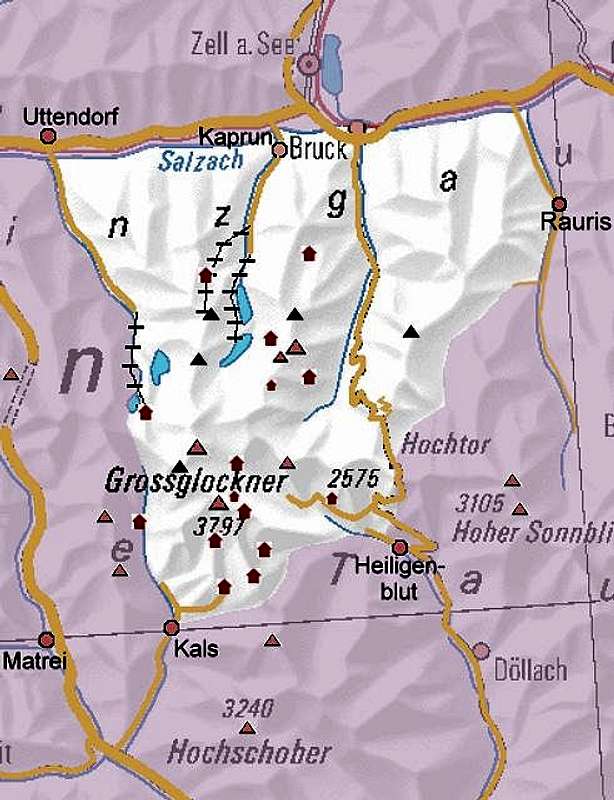
The mountain Grossglockner is the highest, the most important and some say the prettiest mountain of Austria and therefore it is a symbol of Austria as it is Matterhorn for Switzerland. It is also the climax of its mountain group called Glockner Group, that forms not the biggest, but the most important part of the Hohe Tauern Range.

But besides the mountain Grossglockner itself there are many other attractions for tourists, hikers and climbers in his area:

• The hydroelectric power station of Kaprun with its reservoir lakes and dams attracts thousands of tourists a year and give the basis for climbs for example of the Grosses Wiesbachhorn
• The ski resort of Kaprun was the first one in Austria on a glacier
• The pay road Grossglockner Hochalpenstraße allows drivers and motorbikers to come close to the mountains and glaciers
• The Pasterze glacier is still the longest in Austria

History of alpinism in the eastern alps started mainly at Grossglockner and its group.
In order to avoid double info I will concentrate here on Information that is not already on the Grossglockner page.

Geography

The Group lies between the Granatspitz Group west, the Goldberg Group east and the Schober Group south. To the north the Salzach valley separates it from the Kitzbühel Alps and the Salzburg slate Alps.
In politic manner the Group is part of the Austrian states (“Bundeslaender) of Salzburg (full north side), Tyrol (south west side) and Carinthia (south east side). The three states do not meet at Grossglockner (because Glockner ridge spreads into the south side) but at Eiskoegele (3438 m)

„Official“ boundaries are:
- the river Salzach
- the valley of Rauris and the Seidlwinkltal to the Hochtor (highpoint of the pay road)
- the Tauernbach creek to Heiligenblut, the River Möll,
- the Leiterbach creek and the Moosbach creek to the Peischlachtoerl pass
- the Peischlachbach creek to Kals, the Kalser Bach river, the Dorfertal valley, Kalser Tauern pass
- the Stubachtal valley

Valleys for giving access to the mountains are
• from north the valleys of Stubach, Kaprun, Fusch and Rauris
• from south the valleys of Kals and of the river Moell to Heiligenblut.

GrossglocknerGrosses Wiesbachhorn Hinterer BratschenkopfFuscherkarkopfJohannisbergMuntanitzKendlspitzeHochgasserBoeses WeiblHochschoberHoher SonnblickHocharnHoher TennKitzsteinhornHocheiserEiskoegeleSchwarzkopfKrefelder hutGleiwitzer hutHeinrich Schwaiger houseSchwarzenberg hutRudolfs hutOberwalder hutErzherzog Johann hutGlockner bivouac hutKalser Tauern houseStuedl hutLuckner houseGlorer hutSalm hutGlockner houseGruberscharte bivouac hut
Interactive map of Glockner Group: Names are shown if you hoover the mouse over the summit or hut. Red summit symbols have links to their pages

Mountain huts

1. Rudolfshütte Rudolfshütte (new name: „Alpinzentrum Hohe Tauern”) (2315 m), very comfortable alpine hotel that can be reached by cablecar from the Stubach valley. Ideal basis for instruction courses. Unique in the alps!!


2. Kalser Tauernhaus (1755 m)


3. Lucknerhaus (1920 m) at the end of the Kalser Glocknerstrasse pay road

4. Lucknerhuette (2241 m), 1 h from Lucknerhaus

5. Stuedlhuette (2801 m), 2,5 h from Lucknerhaus


6. Erzherzog-Johann-Huette (3454 m), highest hut of Austria, 4,5 h from Franz-Josefs-Hoehe or 5 h from Lucknerhaus

7. Salmhuette (2644 m), 3 h from Lucknerhaus, 5 h from Heiligenblut

8. Glorerhuette (2644 m), 2 h from Lucknerhaus, 5 h from Heiligenblut

9. Glocknerhaus (2132 m), at the Grossglockner Hochalpenstrasse pay road, but still an important basis for hikers and climbers

10. Hofmannshuette (2444 m), 45 min from Franz-Josefs-Hoehe - ruinous, will be knocked down soon

11. Oberwalderhuette (2973 m), 3 h from FranzJosefs-Hoehe, big and important hut for glacier instruction courses on the opposite side of the Pasterze glacier to Grossglockner


12. Schwarzenberghuette (2267 m), 3,5 h from Ferleiten

13. Heinrich-Schwaiger-Haus (2802 m), 2,5 h from Moserboden dam wall

14. Gleiwitzer Huette (2174 m), 3,5 h from Fusch

15. Krefelder Huette (2295 m), 1,5 h from Salzburger Huette (Station of the Kaprun cablecar)

Bivouacs

1. Glockner-Biwak (3260 m), 6 places; 3 h from Franz-Josefs-Hoehe; very important for northern ice climbs of the Grossglockner

2. Gruberscharten-Biwak (3100 m), 9 places, 2,5 h from Oberwalder hut, 2 h from Schwarzenberg hut, 3 h from Heinrich-Schwaiger-Haus; shelter along the glacier routes between these huts

What to do for a mountaineer in this area?

• Of course: climbing Grossglockner or other main summits, for example Grosses Wiesbachhorn, Hoher Tenn, Hocheiser.
Wiesbachhorn and Grossglockner can be combined by a long traverse of glaciers and high passes though conditions may not be good later in summer

• Difficult routes in style of western alps can be found on Glockner north side, including the famous Pallavicini couloir

• Ice climing, see the following sections

• Hiking, see the following sections

• Tour Skiing, see the following sections

• You won’t expect a via ferrata here but more in the Dolomites. But the most difficult “iron route” of Austria can be found near Rudolfs hut: Kristall Klettersteig (description in German)

Ice Climbing

Glockner Group and especially the area around Oberwalder hut is one of the best areas in Eastern Alps for climbing ice faces:

The most difficult climbs are at Grossglockner itself. More easy possibilities – some good for beginners - are at the lower mountains around the Pasterze glacier: a very good overview with descriptions in German can be found here on www.bergsteigen.at with a great pdf-overview.

The best time is not the summer but late spring - May and June - There you notice less that many of the former ice in these faces has melted away in the last decades.
Another possible time is late autumn in some years - when a high pressure period follows the first heavy snowfall.

Reports about the present conditions can be found on www.bergtour.ch (chose Region "Österreich" and Routenart "Nordwände").

Overview:

Eiswandbichl N-face easy 45°, 100m
Grosser Baerenkopf N-face easy 40°, 200m
Johannisberg NE-face easy 50°, 260m
Fuscherkarkopf N-face easy 45°, 450m
Johannisberg W-face easy 45°, 450m
Eiskoegele N-face easy 45°, 250m
Teufelskamp N-face easy 50°, 100m
Grossglockner, Pallavicini couloir difficult 55°, 600m
Grossglockner, Bergler couloir difficult 50°, 460m
Hohe Riffl N-face difficult 60°, 350m
Schneewinkelkopf N-face difficult up to 70°, 350m
Schattseitkoepfl N-face difficult up to 60°, with rocks, 200m
Grossglockner, Schneiderrinne light difficult up to 75°, 400m
Hoher Tenn N-face difficult 45°, 600m
Grosses Wiesbachhorn NW-face difficult 50°, with rocks, 400m
Romariswandkpf N-face very difficult up to 55°, with rocks, 250m
Grossglockner, Mayerl Rampe very difficult up to 70°, 500m
Grossglockner, Theo Riml-Gedaechtnisweg very difficult up to 90°, 350m


In deep winter frozen waterfalls esp. around Heiligenblut or the Rudolfs hut are also a goal for ice climbers

Hiking

Hiking from hut to hut is not possible in every part of the group because of the alpine terrain with glaciers. A recommendation to get to know most of the group on marked routes for an experienced hiker (possible from mid July to end of September) is
1. Kaprun cablecars – Krefelder hut – Alpinzentrum Rudolfshuette
2. Rudolfs hut – Dorfer valley – Kals-Taurer
3. Kals-Taurer – Teischnitz valley – Stuedl hut
4. Stuedl hut – Pfortscharte – Salm hut – Glockner house
5. Glockner house – Pfandlscharte – Ferleiten (bus to Zell am See)
In recent years an extended version of this route is beeing promoted under the brand "Glocknerrunde" and alludes to round treks like the one round Kailash. It is possible to book the trip as a package tour, with or without guide.

Of course you can enter Granatsptz Group, Schober Group or Goldberg Group following marked trails from hut to hut. There are endless possibilities for such trips in the Hohe Tauern (my “alpine career” started in 1983 with a 3-week-hike from Kals) – you won’t find similar possibilities for example in whole Switzerland!

Daytrips are possible (and popular) to every mountain hut of the group.

Tauern-Hoehenweg

This is a long route that follows the Tauern main ridge from east to west. It has two variations in Glockner Group:

a) the difficult one (it is the most difficult part of the entire route) leaves Goldberg Group by the long “Klagenfurter Jubiläumsweg” route from Hocharn to Hochtor. From there it continous in Glockner Group as follows:
- Hochtor (basis may be Wallackhaus on Glockner road) - long traverse following the main ridge - crossing Spielmann (3027 m) - Glockner house at the pay road.
- Glocknerhaus – Franz-Josefs-Hoehe – Oberwalder hut
- Oberwalder hut – Obere Oedenwinklscharte (3233 m) – Alpinzentrum Rudolfshütte hotel: glacier route, rope necessary

b) the variation avoids the glaciers: it comes down to Heiligenblut from Hoher Sonnblick (well, there is also a glacier)
- Heiligenblut – Leiter valley – Salm hut
- Salm hut – Pfortscharte – Koednitz valley – Kals

Ski tours

Some recommendations for ski tours are

• With basis Alpinzentrum Rudolfshuette, though the goals are mostly part of Granatspitz Group

• Grossglockner from Kals – Lucknerhaus in spring (climbing the summit is difficult!)

• Figerhorn from Lucknerhaus

• Trip around Grossglockner in late spring (very hard)

• Daytrips on Kloben, Spielmann, Brennkogel, as soon as the Glockner road is open in May. A taxi can shorten the ascent. This is extremely popular!

Maps and books


Online map available on www.austrianmap.at

Best printed map is Alpenvereinskarte (map of the german alpine club) Nr. 40 “Großglocknergruppe, edition 2002, available on www.dav-shop.de

This map and reasonable hiking maps 1:50.000 can be bought everywhere in the area

Guidebook in german: Willi End: Glockner- und Granatspitzgruppe, 10th edition 2003, Bergverlag Rudolf Rother, Muenchen 1995; ISBN: 3-7633-1266-8

Mountains

The Glockner Group can be sub-structured by following the ridges between the main valleys, especially on the north side

Glockner ridge


This ridge runs from Kalser Tauern pass in SE direction, carrying Grossglockner and its neighbors. Because of steepness, glacier covering and beauty it is often compared with the western alps. East of Grossglockner altitude shrinks and the character of rocks changes completely from the hard, somehow green Serpentin to the very soft brown Kalkgimmerschiefer “Bratschen” that is formed by wind energy to elegant formations as Schwerteck

• Medelzkopf (2761 m)
• Kastenturm (2920 m)
• Hoher Kasten (3192 m)
• Eiskoegele (3436 m)

• Schneewinkelkopf (3476 m)

• Romariswandkopf (3508 m)

• Teufelskamp (3560 m)

• Glocknerwand (3721 m)

Grossglockner (3798 m)

• Hohenwartkopf (3310 m)
• Kellersberg (3267 m)
• Schwerteck (3247 m)
• Schwertkopf (3100 m)
• Leiterkoepfe (2891m, 2602m, 2483 m)

Tauern main ridge

From Kalser Tauern pass to Eiskögele the watershed builds the first part of the – at this location – more important Glockner riddge. The watershed and the Tauern main ridge starts at Unter Öedenwinkelscharte pass (3177 m) NE of Eiskoegele. In the first part the ridge builds the border of the Pasterze glacier. It ends at Hochtor (2575 m), the climax of the Glockner pay road

• Rifflkarkopf (2972 m)
• Totenkopf (3173 m)

Hohe Riffl (3346 m)
• Torkopf (3099 m)
Johannisberg (3460 m)


• Schattseidkoepfl (3193 m)
• Vorderer Baerenkopf (3250 m)
• Mittlerer Baerenkopf (3357 m)
• Eiswandbichl (ca. 3200 m)
Fuscherkarkopf (3336 m, sometimes 3333 m)
• Heiligenbluter Freiwandspitze (3035 m)
• Freiwandkopf (2855 m)
• Freiwandeck (2680 m)
• Sonnenwelleck (Sinabeleck) (3266 m)

• Kapuziner (2850 m)
• Spielmann (3027 m)
• Racherin (3093 m)
• Wasserradkopf ( 3032 m)
• Kloben (2936 m)
• Brennkogel (3018 m)

Stubach - Kaprun ridge


This ridge spreads at Kapruner Toerl (2639 m) from Tauern main ridge. Hocheiser is a worthy high trip. Kitzsteinhorn is well-known because of the summer ski resort of Kaprun. At Grosser Schmiedinger the ridge spreads in some sub-ridges. At Maiskogel there is another ski resort.
The northern part also offer some hiking possibilities.

• Kleiner Eiser (2902 m)
o Hochsedlkopf (2773 m)
• Hocheiser (3206 m)
o Grosser and Kleiner Griesskogel (3065m, 2665m)
Kitzsteinhorn (3202 m)

o Hohe Kammer (2538 m)
• Maurerkogel (2995 m)
o Hackbrettler (2708 m)
• Grosser Schmiedinger (2960 m)

• Kleiner Schmiedinger (2743 m)
o Tristinger (2648 m)
• Lakarschneid (2644 m)
• Zeferetköpfl (2421 m)
• Bombachkopf (2516 m)
o Schoppachhoehe (2069 m)
o Maiskogel (1670 m)
• Große Arche (2453 m)

• Königstuhl (2420 m)
• Planitzer (2562 m)
• Lärchwand (2389 m)

Fusch – Kaprun ridge


The ridge between the valleys of Kaprun and Fusch is the second most important, highly glaciated, and carries very interesting mountains:

• Großer Baerenkopf (3406 m)
• Hohe Dock (3348 m)
• Klockerin (aka Glockerin) (3422 m)
• Vorderer Bratschenkopf (3394 m)
Hinterer Bratschenkopf (3412 m)

Großes Wiesbachhorn (3570 m)


• Kleines Wiesbachhorn (3284 m)
• Sandbodenkopf (2925 m)
• Heidnische Kirche (2540 m)
• Hoher Tenn (3368 m)
• Zwingkopf (3113 m)
• Lorenzkopf (2701 m), Bratschenkopf (2735 m), Zwingspitz (2802 m)
• Peilstein (2358 m)
• Kleiner Tenn (3155 m)
• Bauernbrachkopf (3125 m)
• Kempsenkopf (3090 m)
• Krapfbachkopf (2715 m)
• Vorderes Spitzbrett (2531 m)
• Messerfeldkopf (2446 m)
• Rötenzink (2515 m)
• Imbachhorn (2472 m)

Fusch – Rauris ridge

Besides the start of the ridge at the pay road this is the loneliest corner of Glockner Group, without any glaciers. A Recommendation is a long hike from Edelweißspitze to Schwarzkopf

• Edelweissspitze (2571 m) – only little summit – to mention because it is the only summit that can be “climbed” by car and the highest point in Austria that can be reached with private car. The name is not original but was given by the constructors of the pay road.
• Schwarzkopf (2764 m)
• Hochgamsburg (2276 m)
• Eimbachhoerndl (2237 m)
• Kasereck (1589 m)
• Kreuzköpfl (2095 m)
• Kuehkarkoepfl (2267 m)
• Breitenebenkopf (2235 m)
• Archenkopf (2257 m)
• Drei Brueder (2183 m)

Summits south of the Glockner ridge

There are three rather short ridges south of Grossglockner so the can be put together in one subgroup:

1. Zollspitz ridge

• Gramul (3271 m)
• Gamskopf (3156 m)
• Zollspitz (3026 m) – easy to climb (without route) from Teischnitztal valley
• Kristallspitz (3007 m)
• Saeulsptz (2957 m)
• Bretterspitz (2868 m) - postcard background of Kals

2. Freiwand ridge

• Blaue Wand (2912 m) – short evening walk (but UIAA II) from Stuedl hut
• Kalser Freiwandsptze (2918 m)
• Figerhorn (2744 m) – nice hiking in summer (great flowers) and popular ski tour in winter from Lucknerhaus

3. Blaue Koepfe ridge

• Blaue Koepfe (3135 m)
• Lange Wand (3088 m)
• Leiterkopf (2907 m)
• Medelspitz (2671 m)
• Kasteneck (2824 m)

External Links

  • bergsteigen.at
    overview in German about the ice climbing possibilities in Glockner Group


Parents 

Parents

Parents refers to a larger category under which an object falls. For example, theAconcagua mountain page has the 'Aconcagua Group' and the 'Seven Summits' asparents and is a parent itself to many routes, photos, and Trip Reports.

Hohe Tauern GROUPAreas & Ranges