
|
|
Area/Range |
|---|---|
|
|
46.44000°N / 13.81000°E |
|
|
Hiking, Mountaineering, Trad Climbing, Sport Climbing, Toprope, Bouldering, Ice Climbing, Big Wall, Mixed, Scrambling, Via Ferrata, Skiing |
|
|
Spring, Summer, Fall, Winter |
|
|
8989 ft / 2740 m |
|
|
Overview
Geographical structure: Eastern Alps > Julian Alps
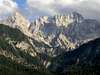
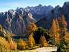
Martuljek group is the subgroup of beautiful Julian Alps and it is one of the most beautiful parts of Julian Alps. Here you can see the beautiful nature, the powerful mountains, you can observe wonderful animals and plants and enjoy in beautiful landscape. This part of Julian Alps is the least visited because the approaches on the mountains don`t have many marked routes so if you want to climb and hike in this parts you must several times mountaineer in your`s own head. Only on the some peaks go marked routes.
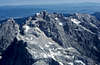
The highest peak of Martuljek group is a powerful Skrlatica. The most recognized and famous mountain in the group is certainly Spik. This beautiful pyramid is the king of the group. Only the Spik, Skrlatica and Dolkova spica you can reach over the marked routes. Other mountains are approachable only over wilderness, through the beautiful forests, over the nice steep grassy slopes, through the big gorges, over the wild and airy ridges, over the steeep faces and ridges…
For me has this group the most beautiful mountains in all Slovenia. If you want to be alone in mountains you must come in Martuljek group.
 |
 |
 |
 |
 |
More Photos of Martuljek group
 ..
.. ..
.. ..
.. ..
.. .
.
 |
 |
 |
 |
 |
More photos of Martuljek group 1
 |
 |
Overview photos
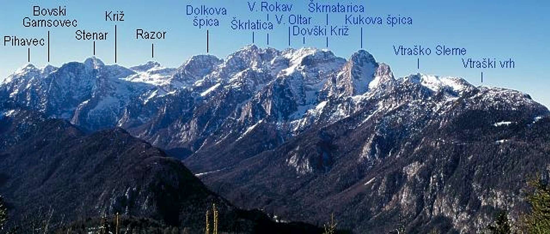
Geographical overview
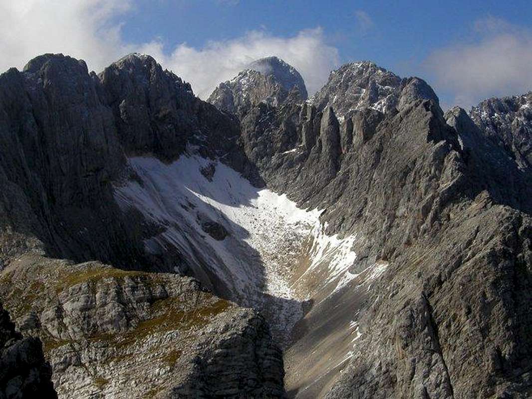
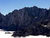
The hidden basin Amfiteater and mountains around it. From the left: Dovski kriz, Visoki Rokav, Skrlatica, Veliki Oltar and Siroka pec from Kukova spica.
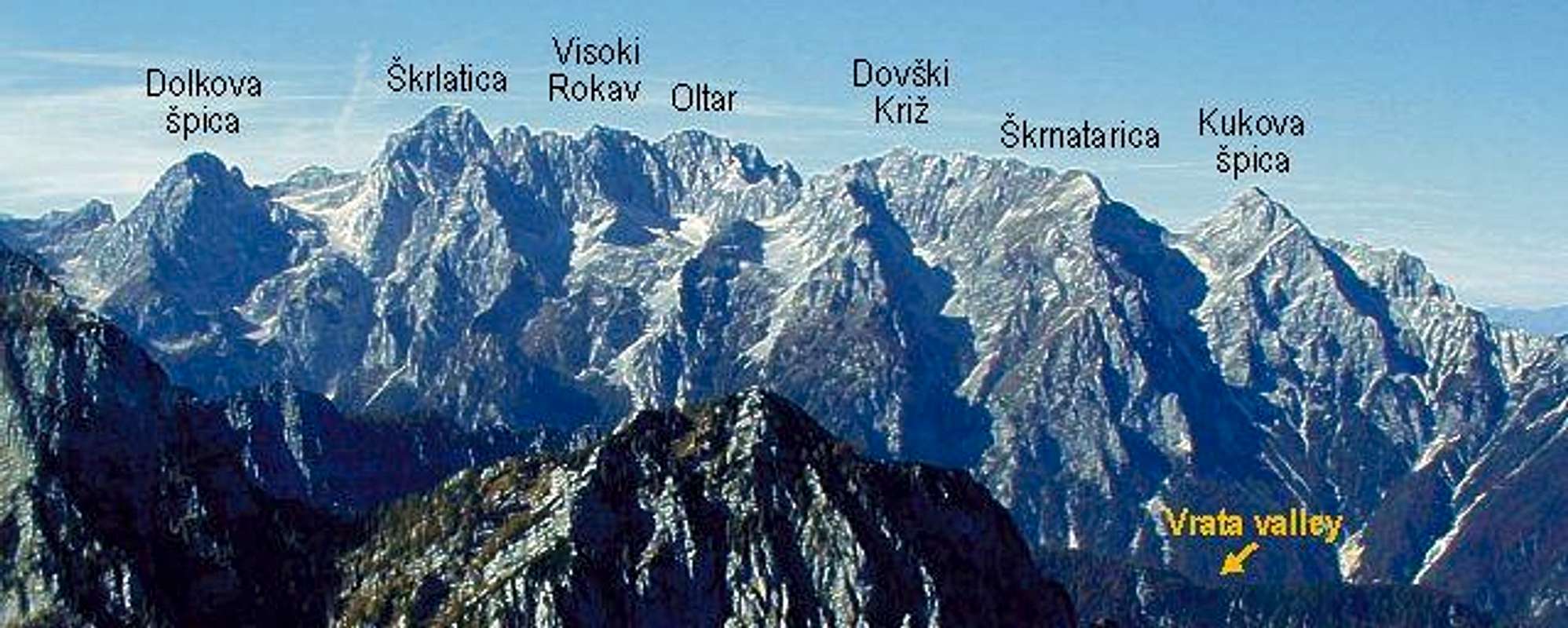
The Martuljek group is surrounded by two big valleys: Krnica valley (on the west side) and Vrata valley (on the east side). On the south side it is connected with Razor and Prisojnik group and on the north side it falls to the Sava valley. At the foothills of mountains in Martuljek group are many big and small villages. On the SE side is the village Mojstrana, which leads on the start of Vrata valley. From Mojstrana in the west direction you come over road in Sava valley to the village Gozd Martuljek. Gozd Martuljek is on the N side of Martuljek group. If you travel more in the west direction from Gozd Martuljek you come to famous Kranjska Gora. Kranjska Gora is located on the NW side of Martuljek group. Then if you continue your trip over the roads and if you go on the route, which goes on the Vrsic pass, you drive through the valley of Velika Pisnica. Velika Pisnica is on the W side of Martuljek group and it is continued to the Krnica valley.
From Kranjska Gora (the NW side) that is on the start of the Martuljek main ridge. The first mountain on the NW of this ridge is the forest Kurji vrh, (1762m), then ridge continues over airy Rusica, (2074m), Vrh nad Rupo, (2108m) and Frdamane police, (2284m) to the king of the group Spik, (2472m). From Spik the main ridge falls steeply to the Spikova skrbina (the notch), (2184m). On the north side is the narrow Spikov graben (the ravine) and on the south side the big ravine, which falls in Krnica valley. From Spikova skrbina ridge repeatedly rises up on Mala Martuljska Ponca, (2502m) and then on its bigger sister Velika Martuljska Ponca, (2602m). Then the ridge continues on the crossing point that is Veliki Oltar, (2621m). From here the main Martuljek ridge goes in the NE direction. The other ridge goes in the SW direction to the Skrlatica, (2740m) and to the small group also called Skrlatica group. In Skrlatica group are mountains: Visoki Rokav, (2646m) (from Visoki Rokav in the S direction there are two more mountains Srednji Rokav, (2589m) and Spodnji Rokav, (2500m)), Rakova spica, (2545m), Rogljica, (2547m), Dolkova spica, (2591m) and the last mountain before Kriska stena (Kriska face) is Dovski Gamsovec, (2440m).
The main ridge from Veliki Oltar goes in the NE way and there are many powerful mountains. First the ridge descends on the Grlo pass, (2390m) and then over the airy ridge ascends on Dovski kriz, (2542m). From Dovski kriz goes to the N side a small second ridge where is the wildest mountain of Martuljek group Siroka pec, (2497m). The main ridge continues in the NE direction on the Skrnatarica, (2448m). Below the N face of Skrnatarica and Dovski kriz and the S face of Siroka pec is a hidden basin Amfiteater or with old name basin under the Siroka pec. This is the most noiseless place in Martuljek group. Around Amfiteater are only mountains and the wild faces. The last mountain in the main ridge from Skrnatarica is the imposing Kukova spica, (2427m). Then the main Martuljek ridge descends over Vrtasko Sleme, (2077m) to the Mojstrana village.
 |
 |
 |
 |
 |
Getting There
The heart of the region is Kranjska Gora resort town, 84 kilometers from the Slovenian capital Ljubljana. From Kranjska Gora you can reach over roads to other starting points of Martuljek group. You can travel by bus.
Mojstrana village, 13km before Kranjska Gora, when coming from Ljubljana, is center to visit Vrata valley.
For more information how to come here check the Julian Alps group page.
Maps:![]() Julijske Alpe - Vzhodni del (Eastern part). Planinska zveza Slovenije. 1:50000.
Julijske Alpe - Vzhodni del (Eastern part). Planinska zveza Slovenije. 1:50000. ![]() Kranjska Gora. Community of Kranjska Gora - Tourist map. 1:30000
Kranjska Gora. Community of Kranjska Gora - Tourist map. 1:30000![]() Triglav. Planinska zveza Slovenije. 1:25000
Triglav. Planinska zveza Slovenije. 1:25000
 |
 |
 |
Valleys
Vrata (Door) is probably the most beautiful alpine valley in Slovenia. It is glacial valley, beginning bellow mighty Triglav and it’s gigantic north wall, spreading towards northeast till Mojstrana village and upper Savska Dolina valley. Powerful creek Triglavska Bistrica runs through it, which source is just bellow Triglav’s Face. Sides of the Vrata valley are very steep and high. Two of the Slovenia’s highest peaks are rising above it. On the north side is Skrlatica (2740m) while on the south is Triglav (2864m) and many other above 2500m. View on Triglav’s 1200m high and few kilometers wide north face is one of the most impressive in whole of the Alps!
Krnica valley is located on the west side of Martuljek group. The valley is beautiful, with stunning scenery. All around are some of the highest peaks of Julian Alps that fall into the valley with huge walls: Skrlatica (2740m), Rakova Spica (2545m), Razor (2601m) and Prisojnik (2547m). Krnica ends with probably most beautiful amphitheater in Julian Alps – Kriska Stena.
Towns and villages
Kranjska Gora
The Zgornjesavska Valley is one of the most breathtaking alpine valleys whose center of activity is the resort town of Kranjska Gora. The valley has developed into a major tourist and sports region, famed primarily for its World Cup competitions in alpine skiing and ski flights on the giant ski-jump in Planica. But it still has much, much more to offer. With its broad variety of tourist services, this alluring valley attracts visitors all year round.
Mojstrana
Mojstrana lies at the meeting point of Triglavska Bistrica with the Sava river, in the immediate vicinity of the Triglav National Park.
The village, surrounded with beautiful mountains, got renowned in the 14th century, when the mining and iron industry started to develop in this area. Nowadays this is a home of a few generations of great mountaineers, climbers, skiers and tennis players, and is known as a great starting point for hikes into the Julian Alps.
Gozd Martuljek
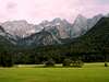
The village is named after one of the most beautiful mountain ranges in the Julian Alps - the Martuljek range. Its highest peak is Spik at 2,472 meters. There is a pachwork of poaring waterfalls under the Martuljek range inviting the romantic and artistic. From Gozd Martuljek is the best view on Martuljek group from the north.
Triglav National Parc
By Velebit
TNP is Slovenian largest national park, which is covering almost entire Julian Alps that belong to Slovenia. First ideas to protect this beautiful area came from Dr. Belar. He proposed, in 1908, 7 Triglav Lakes Valley to be protected. Because of land ownership problems it could not be realized. Finally, in 1924, on the area of 14 hectares, Alpine Nature Park was established in the valley, with time limit of 20 years. After WW 2 came the idea of true National Park. 7 Triglav Lakes Valley, together with Triglav, were declared Triglav National Park in 1961, on the area of 20 square km. But the true objectives of NP could not be obtained so finally in 1981, after years of preparation, true TNP was established. It was significantly enlarged to 838 square km with inner (542km square) and outer circle of protection. Park was named after Triglav, nation’s highest peak and symbol, which is almost in the middle of the park. As Julian Alps are mostly made of limestone, park area is exceptionally rich in various karst phenomena, including a special type of the mountain karst. It includes numerous valleys and peaks. All of Slovenian glacial lakes, except Bled Lake, are inside the park. Park is very rich with flora, which is mostly alpine but due to vicinity of Mediterranean climate there are some endemic species. Lowest point of the Park is only 180m.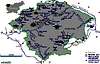
 |
Important mountains
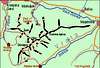
Vid Pogačnik: Below is a map which is at the same time a rather complete guidebook, describing mountains, routes and other features, also illustrating them with pictures. Explore to see details!
Here is some main information of the most important mountains. Some more information you can find on summitpost pages, which are already posted.
Vrtasko Sleme, (2077m).
Vrtasko Sleme is the most eastern summit in Martuljek group. It is the nice summit for tour skiing and in Summer for hiking. From the summit of Vrtasko Sleme you have a beautiful view on many mountains Martuljek group.
Kukova spica, (2427m).
Kukova spica is a very powerful mountain. It is a sharp, rocky pyramid which is very nice seen from start of Vrata valley. 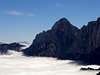
Skrnatarica, (2448m).
Skrnatarica is mysterious mountain and hard approachable. It is nice mountain and from valleys Sava and Vrata hardly recognized. It is the second mountain in main ridge of Martuljek group. The first mountain is Kukova spica.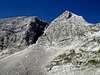
Dovski kriz, (2542m).
Dovski Kriz is a special mountain. It is one of the highest in Martuljek group, but from nowhere it is distinctive, even not seen as a big mountain. Dovski Kriz has so many differnet mountaineering possibilities.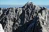
Veliki Oltar, (2621m).
Veliki Oltar is a mountain which is in the middle of the Martuljek group. From its summit is a beautiful view on other mountains. From the village Gozd Martuljek it can be observed in the famous view of these mountains.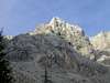
Siroka pec, (2497m).
Siroka pec is the hardest approachable mountain in Slovenia. It is located in the second ridge which comes from Doski Kriz. It is famous by its hard, vertical and dark north face. Siroka pec is composed by many towers. The easiest route is climbing route UIAA III.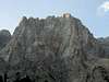
Visoki Rokav, (2646m).
Visoki Rokav is one of the wildest mountain in the group and one of the hardest approachable. It is the highest peak of three Rokavi. There are Srednji Rokav, (2589m) and Spodnji Rokav, (2500m) too. Crossing the ridge of all three Rokavi is one of the most beautiful experiences in your life.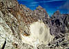
Skrlatica, (2740m).
Skrlatica is the second highest mountain in Slovenia. It is not in the middle of the Martuljek group but is in the second ridge, which comes from Veliki Oltar. It is one of the rare mountain in Martuljek group, which is approachable over marked route.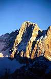
Rakova spica, (2545m).
Rakova spica is the peak, which is located in the ridge that comes from Skrlatica in the direction to Kriska stena (the face). It is hardly approachable and has some nice climbing routes in north face.
Rogljica, (2547m).
Rogljica is the peak, which is located in the ridge that comes from Skrlatica in the direction to Kriska stena (the face). It is hardly approachable and has some nice climbing routes in north face.
Dolkova spica, (2591m).
Dolkova spica is the ninth highest mountain in Slovenia and it’s the last mountain, which belongs to Martuljek group. It is not in the main group but it is in the secondary ridge which comes from Skrlatica, 2740m, from the NE way. On the summit of Dolkova spica leads a marked route.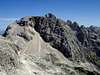
Dovski Gamsovec, (2440m).
Dovski Gamsovec is the last mountain in Martuljek group before the top of Kriska stena (the face) and before the ridge rises up to Razor. It is hardly approachable mountain.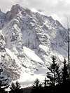
Velika Martuljska Ponca, (2602m).
Velika Ponca is the seventh highest mountain in Slovenia and the fourth highest in the Martuljek group. It leads in the main ridge of Martuljek group, which comes from the NW direction from Spik and Mala Ponca to the summit of Velika Ponca and then continues to the Veliki Oltar.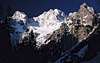
Mala Martuljska Ponca, (2502m).
Mala Ponca is a small “sister” of Velika Ponca and it is located in very wild world between Velika Ponca and Spik. On the north and south side has two nice ravines for alpinist and tour skiing. 
Spik, (2472m).
Spik is the most famous mountain in Martulje group and it is the king in panorama from Gozd Martuljek. It has one of the most beautiful and hardest faces in Julian Alps. It is a beautiful pyramid.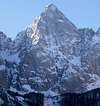
Frdamane police, (2284m).
Frdamane police is a neighbour of Spik. It is not very important mountain but it is powerful. It has beautiful north face and one of the hardest in Martuljek group.
Rusica
The last mountain in the main ridge of Martuljek group is on the west side Rusica. It is combined by two summits. The lower one is called Rigljica, (1911m). Rusica and Rigljica are very hard approachable mountains only for very good climbers.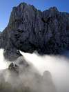
 |
Popular marked routes
Here only some of them. For more information look the summitpost pages of separate mountain.![]() Skrlatica
Skrlatica
- Vrata valley routes. Normal approach on Skrlatica from Vrata valley.
- Krnica valley route. Another possibility to reach Skrlatica from Krnica valley over Kriska stena (the face).
![]() Spik
Spik
- Over Kacji graben. Nice possibility for ascent on Spik.
- Route over Lipnica, (2418m). South approach on Spik. Some secured parts.
There is also many nice paths for strollers and other not very expert mountaineers. The paths are specially in valleys and they are nice for all people, who want just to enjoy in beautiful nature and view on beautiful mountains of Martuljek group.
Nice climbing routes
![]() Siroka Pec
Siroka Pec
- Vzhodni steber. UIAA IV. 600m.
- Cihulova smer. UIAA VI, A2. 600m.
- Krivic-Cedilnik. UIAA VI, A2.
- Opium. UIAA V-VI. 400m.
![]() Mali Oltar
Mali Oltar
- Smer Bucer - Kristan. UIAA IV-/III. 400m.
![]() Rusica
Rusica
- Direktna smer. UIAA V/IV+. 250m.
- Kustrasta smer. UIAA V/IV+. 250m.
- Lijak. UIAA VI+/VI-. 250m.
- Za prijateljice. UIAA VIII+/VII-. 250m.
- Z ognjem in mecem. UIAA VIII-/VII+. 250m.
![]() Frdamane police
Frdamane police
- Schinkova route. UIAA V. 600m.
- Poldaceva route. UIAA VI-,A1/V. 600m.
- Libereška smer. UIAA VI, A0.
- Čebelica. VI-, A2.
![]() Spik
Spik
- Direktna smer (Direct route). UIAA V+. 900 m.
- Spikova direttisima. UIAA V+/IV-V. 900m.
- Dibonova smer. UIAA IV+/III-IV. 900m.
![]() Skrlatica
Skrlatica
- Skalaski steber. UIAA V-/IV. 500m.
- Skrlatiske grede.UIAA III/II.
- Juzni Greben. UIAA IV-/III. 350m.
![]() Rakova spica
Rakova spica
- Smer po Stebru. UIAA V-/IV. 600m.
- Desna zajeda. UIAA V+/IV-V. 500 m.
- Svicarska smer. UIAA VI,A1/V+. 500 m.
![]() Rogljica
Rogljica
- Centralni steber. UIAA V+/IV. 500m.
 |
Mountain huts and bivouacs
![]() Huts:
Huts:
Aljazev Dom (1015m) (Aljaz Hut) is placed in upper part of Vrata valley, near the forest end. It is accessible by car, 12km from Mojstrana village, which lies on the main road from Ljubljana (72km) to Kranjska Gora resort (12km). It was opened in 1896. In 1909 the hut was destroyed by avalanche. New hut was opened the next year where it stands today. It has 150 beds and is open from beginning of May till the end of October. Winter room has 8 beds. Hut also has phone, electricity, warm water and so on. From the hut view is beautiful on the peaks around the valley, which rise wildly above it, and especially on Triglav and its North face.
Koca v Krnici (1113m) (Hut in krnica) stands on a small meadow in conifer forest on the bottom of Krnica valley. The valley is surrounded by high peaks: Skrlatica (2740m), Razor (2601m) and Prisojnik (2547m). Opening year was 1933. It is open from May 1st till October 31st, while outside that frame during weekends and holidays. It has 20 beds, water and power from a generator. 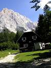
![]() Bivouacs
Bivouacs
Bivak I (2180m) is located below the SW ridge and face of Velika Ponca and is maintained by Mountaineering Club Jesenice. Address: Cesta zelezarjev 1, 4270 Jesenice; tel.: (04) 586-60-70. It is very small and has only three beds.
Bivak II (2118m) is located on the plateau Na Jezerih below Dovski Kriz, Veliki Oltar and Rokavi on the SE side above Vrata valley. It is maintained by Mountaineering Club Jesenice. Address: Cesta zelezarjev 1, 4270 Jesenice; tel.: (04) 586-60-70.
Bivak III (1340m) is located on the start of the plateau Za Akom on the north side of the main Martuljek ridge. It is maintained by Mountaineering Club Jesenice. Address: Cesta zelezarjev 1, 4270 Jesenice; tel.: (04) 586-60-70.
Bivak IV na Rusju (1980m) (Bivouac IV on Rusje) stands high above Vrata valley, on the slopes below Dolkova Spica (2591m) and Stenar (2501m), since 1948. During the 1950/51 winter it was blown away in the storm and ended up some 80 meters away. In 1953 a new one has been built. It is constantly open and has 10 sleeping places, furnace and water reservoir.
Bivak pod Spikom. Under the north wall of Spik, north face of Frdamane police and south face of Rusica there is a Bivouac (1424 m). The keys are held by Mihaela Oman, Zg. Rute 24, 4282 Gozd-Martuljek, (04) 588-08-65 (Mountaineering Club Gozd Martuljek).
Camping
Camping inside the Triglav National Park is forbidden. Beside the mountain huts there are plenty of hotels and private apartments in the towns and villages, which surround the area. Here are few links where you can find info on accommodations closer and further away:
Kranjska Gora
Mojstrana
Bled
Mountains On Summitpost
Skrlatica, Velika Ponca, Veliki Oltar, Dolkova spica, Dovski kriz, Spik, Skrnatarica, Kukova spica, Frdamane police, Rusica, Siroka pec, Dovski Gamsovec.
Mountain and weather Conditions
Mountain conditions in Julian Alps are well known, thanks to Kredarica (2515m) hut and meteo station, which is bellow the Triglav.
You can observe current conditions and forecast for Kredarica on the Wunderground meteo site. Here is direct link to Wunderground - Kredarica page.
Some weather informatin can also be found here.
Bor - Nov 8, 2004 1:07 pm - Hasn't voted
Untitled CommentYes I like the map too!! Thanks Vid!!
Do you see the map on M&J page now? I had to wipe all script of "href..and so on! ;-)
Thanks!
Vid Pogachnik - Nov 8, 2004 1:40 pm - Voted 10/10
Untitled CommentYes, I saw it. And it's better :-)
Vid Pogachnik - Nov 8, 2004 12:49 pm - Voted 10/10
Untitled CommentI like the map now. You copied the text below the map, so it's wrong - it should be: "...point on (or hover over) summits to see their names, click on them to get their SummitPost pages."
Bor - Nov 8, 2004 1:07 pm - Hasn't voted
Untitled CommentYes I like the map too!! Thanks Vid!!
Do you see the map on M&J page now? I had to wipe all script of "href..and so on! ;-)
Thanks!
Vid Pogachnik - Nov 8, 2004 1:40 pm - Voted 10/10
Untitled CommentYes, I saw it. And it's better :-)