

-
 52530 Hits
-
 96.98% Score
-
 64 Votes
|
|
Area/Range |
|---|---|
|
|
47.42000°N / 13.05000°E |
|
|
9649 ft / 2941 m |
|
|
Overview
Geographical structure: Eastern Alps >Berchtesgaden Alps
The Berchtesgaden Alps (Berchtesgadener Alpen) is an important group in the East Alps, situated at the northern declivity. With an area from about 1500 square kilometers, rich in beauties of nature and in mountaineering possibilities was this region since more than 200 years object for hikers and climbers. In the last years ski mountaineering, paragliding, canyoning and other mountain sports accrued.
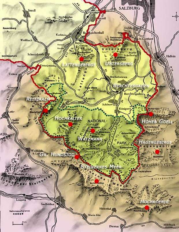
In the overview map (interactive - but not all red spots are active yet!) you see the German part of the Berchtesgaden Alps inside the red line. The "market" of Berchtesgaden is situated in the heart of this enclave. The National Park is marked with green stars. The brown area shows the Austrian fraction of the Berchtesgaden Alps.
The territory runs from Salzburg and Bad Reichenhall in the North to Bischofshofen and Saalfelden in the South, from Salzach river in the East to Lofer and Saalach river in the West.
From Bad Reichenhall, a medium sized city, known since 200 years as health resort, leads a valley into the heart of Berchtesgaden Alps, the bassin of Berchtesgaden. First with steep woody and rocky slopes on both sides, then spreading wide into the bowl of Berchtesgaden valley. Here you'll find a nice small town, the celebrated Koenigssee, the legendary Watzmann - and thousands of tourists from the whole world.
But you find also a lot of wonderful mountains worthwhile not only one single ascent.
From Berchtesgaden you can reach each part of this group, but also it's possible - and often more reasonable - ascend this mountains from the outer borders (Lofer, Saalfelden, Bischofshofen, Werfen, Hallein, Bad Reichenhall and the other locations between this small towns). Some parts (Steinernes Meer) you reach best with boat over the celebrated Koenigssee, located in the heart of the National Parc.
 |
 |
 |
 |
 |
Geography
Berchtesgaden Alps include 9 beautiful and interesting subgroups, each consisting in several attractive summits:
- Hochkoenig (2941 m) This is its own world, segregated from the main part of the Berchtesgaden Alps, nearly independent, and nevertheless an important part of our Berchtesgaden Alps. The main summit is the highest point of the whole group, nearly 3000 m. Situated totally in Austria it is a plateau too, largely covered with snow and ice. On the S-side loom mighty walls with Gordian climbs, deep cirques and narrow couloirs. Most important summits of this group are - beside Hochkoenig - Hochseiler (2793 m) and Grosser Bratschenkopf (2859 m). But here you find also at least a dozen of interesting summits for lonely hiking, climbing and skiing, e.g. Torsaeule (an audacious pillar with 2587 m) and Manndlwand (a chain with about 30 peaks and pinnacles).
- Watzmann (2713 m). It would be " to carry coals to Newcastle", to praise "King Watzmann". One of the most renowned mountains on the world, not only between mountaineers. But also Watzmann is more than a mountain, it is a really impressive group of mountains, in most parts lonely and originally. Only on the "head of the king" you'll find hundreds of people on sunny days in summer. See more in the Watzmann page.
- Steinernes Meer (2655 m) Another immense plateau, a "sea of stones", like the name suggests. It has an other character as Reiteralm, it's not idyllic, there are few meadows and alps. You find stones and stones, in the inner part nearly without structure, chaotic, overwhelming … The edges however are here too haughty summits with steep slopes and walls, inaccessible in large sections for those who not are extreme climbers. But in the fringes you find definitely creeks and lakes, woods and meadows.
Important summits are Schoenfeldspitze (2655 m), Grosser Hundstod (2594 m), Funtenseetauern (2579 m), Selbhorn (2655 m), Brandhorn (2610 m) and many other names.
- Hochkalter (2607 m) This is a magic empire within Berchtesgaden Alps! The main summit is a lordly mass of rocks, at his base you'll find the northernmost glacier of the Alps, a steep ice field with several crevasses, surrounded by aspiring walls. But Hochkalter Group is more: it is a chain with numerous ridges, summits and high situated valleys, oftentimes completely lonely and with great beauty. Beside Hochkalter himself you find summits like Ofentalhoerndl (2513 m), Steintalhoerndl (2468 m), Hocheisspitze (2523 m), Hochkammerlinghorn (2506 m) and some more.
- Hoher Goell (2522 m) A mighty massif, connected with Hagengebirge in the notch Torrener Joch (1731 m), made up of only two main summits, Hoher Goell and Hohes Brett as well as two important pre-summits: Jenner (1874 m) and Kehlstein (1834 m). The latter are famous for they great panorama, her comfortable accessibilitiy by bus and teleferic and last but not least Kehlstein - because of its doleful history.
Just here has the awful Hitler a house built: "Hitler's Teahouse" or "Eagles Nest" - visited from thousands coming out of the whole world. But theese are not mountaineers or climbers mostly …
But the mountains cant't help it! They are even so beautiful elevations, and when you go up to these two summits early in the morning or late in the evening, you can find a great piece of mountain nature and will see perhaps not one human soul (but - in case of Jenner - alpine marmots).
Hoher Goell himself is a great mountain, worthwhile not only one ascent: hiking, climbing, skiing - there is no approach which is not inspiring - see the Hoher Goell page!
- Hagengebirge (2361 m) Surely the most solitary subgroup of Berchtesgaden Alps! In the western part we find some summits visited more often from Berchtesgaden: Grosses and Kleines Teufelshorn, Kahlersberg and Schneibstein. The large plateau arranged behind however does not see many people. But it is touristically not very interesting: a never-ending up and down, rocks and dwarf-pines ...
At the edges of this massif you'll find once more several summits, but they are not visited often too.
Normally Gotzenberge will be added to Hagengebirge: a lovely little "sub-sub-group", joined with Hagengebirge only through one notch: the so-called Hochgschirr (1949 m). Here you'll find meadows, alps and beautiful woods. Popular is the large and idyllic Gotzenalm (1685 m). Few minutes ffrom here you have one of the most inspiring view to Koenigssee and Watzmann with his E-face: Feuerpalven, a superfine viewpoint.
- Reiteralm (2286 m) A nearly squarish plateau (like several subgroups of Berchtesgaden Alps) with meadows and huts in the middle and respectable summits at the sides. The Arcadian character of the soft hills in this square bluffs, on four sides you find vertical walls confining this closed little world.
Some of the hardest routes of this world you'll find here and large quantities of difficult and serious climbs. Some of the most important summits are Stadelhorn (2286 m), Wagendrischelhorn (2251 m) and Haeuslhorn (2284 m). But you find more than a dozen of worthwhile mountains. A really great mountain group …
- Untersberg (1972 m) Another large plateau, in its center interesting only in winter, when you can traverse this endless tableland. But the walls on the S-face are celebrated for their terrific climbs. This are the three climbing paradises in Berchtesgaden Alps, well known under climbers in the whole world: Untersberg S-face, Hoher Goell W-face and Reiteralm S-, W- and N-faces.
- Lattengebirge (1738 m) Last but not least the lowest mountain subgroup in Berchtesgaden Alps. In first line a region for hikers and aficionados of loneliness with charming creeks, deep and steep canyons and expanded woods, it has some climbing needles too: the towers on the E-slope called Rotofentuerme (1369 m). They are not high but nice climbing targets for spring and late autumn, when snow lies over the higher summits. Popular they were called "the sleeping witch" because of their characteristical shape
In the Berchtesgaden bassin you'll find some lower summits, which give you a great panorama: Kneifelspitze (1189 m) and Totermann (1391 m).
A great part of this mountains belong to the National Parc Berchtesgaden (see below).
Berchtesgaden Alps group is situated partially in Germany, partially in Austria. The frontier goes often directly over the summits. There are no formalities and controls are extremely seldom. But you must always have your passport with you - don't forget it!
 |
 |
 |
 |
 |
History
In early times (e.g. the medieval) the mountains and expanded woods were hostile for the humans and only trodden, if it was essential (e.g. for hunting, salt mining and so on). Hunters and shepherds came at all times in these hard and dangerous backcountries. Even they reached the summits, but the first touristic actions began in middle of 18 th century. Between 1780 and 1900 all important summits of this nature paradise was climbed, and the early mountaineers began to explore more difficult and challenging routes. One of the most important precursors was Hermann von Barth. A significant number of the great alpinists have here established interesting and important routes. In the fifties and sixties all major paths and routes in this group was known and the experts began with discovering the extreme climbing routes through the walls of the great summits, especially of the big plateaus Reiteralm (Reiteralpe), Untersberg, Hochkoenig and Steinernes Meer and the great walls of Hoher Goell. Celebrated names are Huberbuam (Alex and Thomas Huber), Albert Precht and many others. Today Berchtesgaden Alps are playground of extreme climbers as well as the moderate climbers, hikers, skiiers and all who want to experience nature and wilderness.
National Park Berchtesgaden
About 1900 there was first ideas of nature protection in Berchtesgaden, 1921 they founded the first nature reserve and 1978 was established the National Park Berchtesgaden with 210 square kilometers. It is the same idea like in many other countries: nature should be kept in its original status and can develop according to its own laws, as much as possible undisturbed through the man. This stands of course in a certain antagonism to the requirements of tourism (and hiking and climbing are a form of tourism). So you must maintain a series of rules. It is in all creatures interest, that the idea of National Park is successful.
 |
 |
 |
 |
Getting There
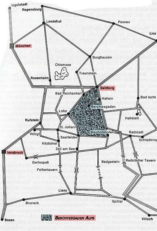
The Berchtesgaden Alps are easy reachable. Best you go via Munich with car or train to Salzburg, Bad Reichenhall and Berchtesgaden. Also if you're coming from south (e.g. Italia, Austria, Slovenia, Croatia) you reach the region via Salzburg, there is an important airport too. The places in E, S and W of the group are reachable directly by car, but it is a bit complicated (see the map). You can get there also with train or bus from Salzburg or Freilassing (a train node near Salzburg). Arrived in Berchtesgaden you reach each starting point by bus (RVO).
Red Tape
There is no red tape in the whole region - no permits, no fees! You are free as a bird - nearly. A great part is located in the National Park, there you must accept certain rules, e.g. not to camp and make fire. You may not pick plants etc. In the other parts of the Berchtesgaden Alps rules are not so strict.
There are some private roads, you can use but must pay toll (Rossfeldstrasse, Arturhaus). Using the ships on Koenigssee is not very cheap but a worthwhile event.
When To Climb
Berchtesgaden Alps you can visit the whole year. In winter you can undertake great skitours, but the mountains and slopes are steep, often riddled with rocks and the danger of avalanches is not to underestimate.
Best time for hikes and climbs is middle of June to middle of October. In this time all huts are opened and you find snow only on the high summits, if at all.
Camping & Huts
In the Berchtesgaden Alps are numerous huts for reaching all summits. Camping in the wilderness is not usual - and in the National Park it is strictly forbidden. Names, telephone numbers and - if available - e-mail-adresses or websites of alpine huts are given in the single summit pages. Their quantity is to large to specify them here.
As member of an Alpine Club (e.g. DAV/OEAV) you can stay always there, but in summer it is reasonable to phone before and book a sleeping place.
In the other times in some huts exists an uncomfortable and mostly cold "Winterraum", sometimes always open, sometimes only with key (available in the "sections" of the club in the valleys).
On the other hand you'll find in the valleys a lot of camping places (some adresses you will find at the summit pages). But it is also usual to stay in the innumerable guest houses and hotels. If you want it cheaper, it's a good idea to visit the youth hostel in Berchtesgaden.
If you plan vacations in this region, you look best at the websites of tourism organisations of the single locations (e.g. www.berchtesgaden.com, www.lofer.net, www.saalfelden-leogang.info, www.salzburg.info and others you can find without problems in the internet.
Mountain Conditions
WebCams and other area information (weather, lodging, events) can be found through webpages like www.wetter-berchtesgaden.com and www.meteoalpin.com/fs_ti.php . A good webcam from Berchtesgaden and Watzmann you find here: www.wetter-berchtesgaden.com/WebCam_1/kneifelspitze.jpg
Ingenious! Here you find an overwiew to all webcams in Europe - and so of the the alps too: www.sionvalais.com. (You find there 3711 webcams!).
Especially for the Berchtesgaden Alps are interesting the Berchtesgaden webcams and the Salzburg webcams.
 |
 |
 |
Books & Maps
As SP's Books page does not allow entry of books outside of Amazon.com's US site, and there are very few English-language books on the Berchtesgaden Alps, here are links to some german books.
Books:
- AV-Führer Berchtesgadener Alpen, Bergverlag Rudolf Rother, 1994. ISBN: 3763311270
- Die Schönsten Hochtouren um Berchtesgaden. Verlag Plenk, Berchtesgaden 1997. ISBN: 3-927957-05-4
- Rasp Franz: Watzmann-Ostwand - Ein Führer für die Begeher der klassischen Routen der Ostwand. Bergverlag Rudolf Rother, 2nd edition 1990. ISBN 3-7633-4141-2
- Watzmann. Mythos und wilder Berg, Horst Höfler, Heinz Zembsch, 2001. ISBN: 3905111616
Comments from SP Member guenni: Illuminates the huge mountain from all sides. Recommendable. Horst Höfler is a well-known mountain photographer. Heinz Zembsch is leader of the "Erste Bergschule Berchtesgadener Land ".
- Ein Watzmann-Ostwand-Buch. 7th edition, Verlag Anton Plenk KG, 1981. ISBN: 3-922590-05-5
Comments from SP Member guenni: Exhausting presentation of the east-face-history. A little bit lofty, but nevertheless worth reading. Newer editions may be available.
Maps:
- Topographische Karte Nationalpark Berchtesgaden 1:25 000, 20m. Bayerisches Landesvermessungsamt
- Österreichische Karte Nr:93 1:25 000, 20m. Bundesamt für Eich- und Vermessungswesen.