
-
 64113 Hits
-
 95.51% Score
-
 53 Votes
|
|
Area/Range |
|---|---|
|
|
45.42930°N / 7.53662°E |
|
|
15770 ft / 4807 m |
|
|
preface
This page has been posted just to have a starting point to define the main western structure of the Alps and to have a "shopping list" pointing out the "missing" pages that should/could be posted
The structure partially follows the new partition of Alps defined by Soiusa trying not to lose all the usual, old and well-known concepts about alpine regions :
this is very important, especially for the French side of the Alps, where a parallel structure is placed beside the main watershed and, above all, to avoid that a pure geographical structure can enter in conflict with the grouping structure well known by climbers and mountaineers.
The setup is temporary, the page will be in development until all the related group pages, much more detailed, will be posted.
I hope someone will use some of the contents to create new pages about each region/range so that we can leave here only the links and the main logistic info for each section
How to read this page :
- each section is a wide area, well geographically divided by well-defined borders
- inside each section, the description of the sequence of summits and groups
- if a summit has a SP page the link is put directly on it
no links means that on SP info are still missing
- the ranges and groups are sequenced clockwise starting from SE
Overview
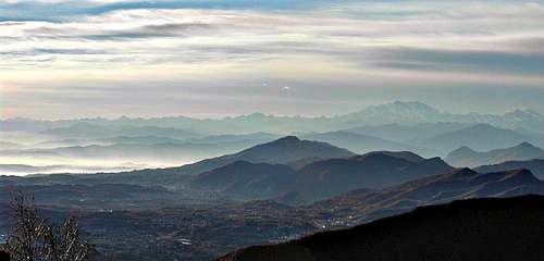
A general overview of the Western Alps is not easy to be done ...
there are too many kinds of environments quite different from each other but we can generalize them just using the below sections :
So we have :
a main ridge-watershed hosting, clockwise from SE to NE, the following sections
- Alpi Liguri and Maritime: once they were considered as undistinguished,
here we can find 2 really important groups with steep walls and channels :
the Marguareis, with its important vertical granite walls: one example is the N wall of Cima Scarason (one of the most difficult walls in the Alps, very little known ...)
the Argentera with its typical alpine look, this group has the same typical structure of a Central Alps mountain (on its northern side it hosts a steep fine channel: the Canalone di Lourusa, and a sequence of fine rocky summits full of old fashion climbing routes) - Cozie Alps (Occitania) :
These are smaller mountains -except Monviso-, eaten by the time due to sedimentary metamorphosed rocks, with normally not extremely difficult slopes and ridges wherefrom, sometimes, fine shaped summits poke out.
The whole main ridge, and of course the secondary ones that are the borders of long and deep valleys, is a real paradise for hikers that can find here the (I think) best trekking tour of the Alps: the GTA - Graie Alps :
Apart from the main watershed, made of "middle-sized" high mountains, a big subrange can be associated to this range: Gran Paradiso. As for Mont Blanc and Ecrins Range, skills and experience are required for alpine climbing activities (climbing is to be understood here as a real alpinistic activity). - Mont Blanc range has a special situation in the Alps : Situated on the main watershed, it is a central subrange too.
- Pennine Alps and South Valais groups :
the widest high area of the Alps, here you can find most of the well detached high mountains laying in long and high ridges.
Few of the main summits here are really easy, almost all require experience, training and fitness.
Even the secondary mountains, on both sides of the watershed, are not so easy ones, especially when they are close to the main ridge. - Lepontine Alps:
a "normal" long, indented and complex ridge hosting a great variety of mountains, for all kind of skills and engagement .. mountains for all seasons and for all tastes
A set of central sub-ranges.
situated west of the main watershed in France from High Dauphiné to Faucigny, including - Belledonne,
- Grandes Rousses,
- Vanoise and Mont Blanc ranges,
continuing north of the main watershed with Switzerland central ranges : - Diablerets,
- Jungfrau sub range (everyone has heard about)
- Tödi and the main part of Glarus sub range (maybe less have heard about)
Mont Blanc, Bernese and Ecrins Range are a paradise for alpine climbing activities wherefore a high level of skills and experience is required.
Rock is, in the highest central ranges, mainly Granite and Gneiss.
Some limestone north faces in Bernese Alps are an exception.
A set of pre-alps sub-ranges,
situated west of central subranges in France from Haute Provence Prealps to Chablais, including - Diois,
- Vercors,
- Chartreuse,
- Bauges,
- Bornes prealps
continuing with Switzerland Prealps : - Sarine-gruyère Prealps,
- Emmental Prealps,
- Vierwaldstäten Prealps,
- Appenzell prealps,
and the Prealps leaning toward East/North to join with the Austrian/German Prealps.
Limestone is the most common rock in Prealps mountains.
Alpi Liguri
from Colle di Cadibona to Colle di Tenda
This range starts a few km N of Savona, grows slowly toward West with wild but not high summits, follows the border between Liguria (S) and Piemonte (N) till the small group of Mongioie (2630m) and Marguareis (2661m).
Here the watershed starts dividing France (W) from Italy (E) with a ridge going toward S with some remarkable summits : M.Bertrand (2461m), Monte Saccarello (2200m), Cime de Marte (2136m), M.Pietravecchia (2040m) and, the last one, l'Arpette (1610m)
Main groups![]() Marguareis-Mongioie
Marguareis-Mongioie![]() Saccarello
Saccarello
Marittime
from Colle di Tenda to Colle della Maddalena
A well defined watershed between Piemonte (NE) and French Maritime Alps (SW)
it starts from the group of Argentera (3297m), the highest of this range, and follows with a ridge near to 3000m of height almost hosting some remarkable summits like Testa Malinvern (2939m), the Mt. Tenibre (3031m) and the Mont Enciastraia (2955m)
From this last summit, just before the Colle della Maddalena, a ridge goes first toward West then toward SSE : this is the Mercantour
main groups here![]() Clapier-Argentera
Clapier-Argentera ![]() Mercantour Tenibre
Mercantour Tenibre ![]() Enciastraia
Enciastraia
Haute Provence
Alps
from Col de la Cayolle to Col de Toutes Aures![]() Mont Pelat - Le Grand Coyer
Mont Pelat - Le Grand Coyer![]() Montagne du Cheval Blanc
Montagne du Cheval Blanc
Ubaye Group
Provence mountains - are usually considered to be out of the alps
between the rivers Verdon and Durance and Mediterraneo sea![]() Sainte Baume
Sainte Baume![]() Maures
Maures![]() Esterel
Esterel![]() Prealpi di Grasse
Prealpi di Grasse
Cozie
from Col della Maddalena to Col del Moncenisio
This range is also known as Alpi Occitane and hosts one of the best trekking-hiking tour of the whole western Alps section : the GTA (Grande Traversata delle Alpi) ... almost 1000km
The range is made by 6 main groups that can be accessed along - 6 different valley from East (Italy)
- 3 different valleys from West (France)
Mountain shapes are very various, and normally climbing activity here is, due to the not fantastic quality of rock (with some exceptions), "classic old-style", some ranges are very good for ski-mountaineering activity and for Mountain biking
Some geographical info :
Above the Colle della Maddalena (Col de Larche) the ridge grows with the M.Oronaye (3100m) then goes on, without descending under the 3000m, to the Brec de Chambeyron 3389m, the Aiguille de Chambeyron (3411m).
The ridge now comes down to the Col de Maurin (2637m), rises with the M.Maniglia (3177m), goes down to the Col d.Autaret (2875m), rises again with the Mongiòia (3340m) goes down, after the Roc d.Niera, to the Colle dell'Agnello (2748m) wherefrom rises to the most important summit of the range : the Monviso (3841m).
North of Monviso, after the minor summit of M.Granero (3171m) the ridge falls down to the Col della Croce (2298m) grows slowly to the P.Ramiere (3303m) and the P.Merciantaira (3293m) then goes down sweet to the Col de Montgenevre (1760m)
between the Montgenevre and the Col di Moncenisio (2100m) where this range geographically ends, the Val di Susa
Dauphiné
Out of the main watershed of the Alps, on its western side, a big high group with the highest mountains west of Mont Blanc, this is the Dauphinè.
Alps
from Col du Galibier to Col Bayard![]() Pelvoux - Ecrins
Pelvoux - Ecrins![]() Champsaur
Champsaur![]() Maurienne
Maurienne
Prealps
between the rivers Durance, Isère and Rodano![]() Luberon
Luberon![]() Vancluse
Vancluse![]() Vercors
Vercors![]() Le Dévoluy
Le Dévoluy
Graie
from Colle del Moncenisio to Col de la Seigne
This is a very wide region, bordered to the south by the Val di Susa, to the West by the massif de la Vanoise and to the North by the big Mont Blanc group
Here we have a watershed ridge that is well defined in its lower part (Piemonte), the part between the Moncenisio and the Col de la Galisia :
these are known as Alpi di Lanzo or, better, as Alpi Graie Meridionali
More than speaking about mountain groups, here is better think about access valleys : on the French side (W) we have a unique, long valley, the Arc valley that directly borders the whole range, while on Italian side (E) we have 4 valleys divided by not short and not small ridges.
Starting from the Galisia we have 2 well opposite ridges : - the Eastern one, very big (the lower point is the Colle del Nivolet -2612m), that, dividing Piemonte from Val d'Aosta, becomes the big group of
Gran Paradiso (4061m) with its sugroups of the Grivola and the Emilius-Tersiva - the Northern one, better known as Alpi Graie Settentrionali, is the main watershed that, through a fine series of mountains posted on a ridge whose elevation is between the 3000 and the 3751m (Aiguille de la Gran Sassière), ends, after the Group of Rutor (3486m) to the Colle of Piccolo San Bernardo (2188m)
North of Piccolo San Bernardo a small range, with some fine easy mountains, leads to the Col de la Seigne (2516m)
from Col de la Seigne to Col du Grand Ferret mountains enter in another dimension with the Mont Blanc group that geographically belongs to range but is really a world apart
Savoie
Alps
from Col du Bonhomme to Col de Montets![]() Dents du Midi
Dents du Midi![]() Alpes du Chablais
Alpes du Chablais
Prealps
between the valleys dell'Isère and Rodano till the Lake of Ginevra![]() Aravis - Pointe Porceè
Aravis - Pointe Porceè![]() Chartreuse
Chartreuse![]() Prealpes d'Annecy
Prealpes d'Annecy![]() Pr. de Bauges
Pr. de Bauges
Pennine and Valais
from Col du Grand Ferret to Simplon pass
this is the main collection of high summits in the whole Alps
the range is oriented W-E in its first part (till the M.Rosa) than changes toward N.
dissecting, using a detailed map (and trying to get out my memories), the structure of Pennine Alps there could be some more well-defined groups ...
the whole range could be divided, for better understanding, into 3 sections :
western section from col Ferret to the Tète Blanche :
central section from Tète Blanche to the Col del Lys
northern section of the range is quite easy to be defined, ranges are well distinct by deep valleys and go down to the bottom of the Wallis ...
further info in Alpi Pennine - Pennine Alps page![]() Grande Rochere - Grand Golliaz group
Grande Rochere - Grand Golliaz group![]() Fallere group
Fallere group![]() Velan
Velan![]() Grand Combin
Grand Combin![]() Gelè
Gelè![]() Rayette
Rayette![]() Ruinette-Chelion-Arolla
Ruinette-Chelion-Arolla![]() Collon - Tète Blanche
Collon - Tète Blanche![]() Weisshorn
Weisshorn![]() Dent d'Herens - Matterhorn
Dent d'Herens - Matterhorn![]() Chateau des Dames group
Chateau des Dames group![]() Monte Rosa group
Monte Rosa group![]() Grand Tournalin
Grand Tournalin![]() Testa Grigia
Testa Grigia![]() Corno Bianco
Corno Bianco![]() Mischabel group
Mischabel group![]() Monte Moro range
Monte Moro range![]() Weissmies group
Weissmies group
accesses :
from Italy (South) : the Val d'Aosta and its subvalleys toward North
from Switzerland (North) : th Wallis and its subvalleys toward South
Bernesi
Bernese Alps
between the rivers Rodano, Reuss and Aar
4 well-distinghished groups here :![]() Les Diablerets
Les Diablerets![]() Jungfrau
Jungfrau![]() Finsteraarhon
Finsteraarhon![]() Aletschorn
Aletschorn
Lepontine and Ticinesi
between Simplon pass and Splugen pass
this is a wide range oriented W-E that is the main watershed of Europe, on its northern side the Rhein river basin, on its southern side the Po river basin.
Mountains in this range are not as high as its W neighbours ((Pennine Alps where the ridge is often over the 4000m) nor as its E neighbour (Retiche Alps where the ridge is often over 3600m)
on the other side, this range is normally deep and the distances between N and S main valleys are normally big.
Wide variety of rocks .. starting with the fantastic granite near the St. Gotthard and ending with the crumbly rocks in its eastern part, somewhere, especially in the eastern part some dolomite or limestone banks come out in the main ridge ...
A great variety of climbing difficulties ... extreme climbing on granite, fine alpine climb on most of its summits, a large choice of fine hiking routes, the best range to start mountaineering without big risks.
These summits are sometimes busy, full of Lombardic and Ticinesi climbers or hikers that, starting from home, can climb almost all these summits without having to spend the night in refuge or elsewhere but home ...
... few come from abroad, unknowing what they lose :)
further info in the page about Alpi Lepontine![]() Leone group
Leone group![]() Blinnenhorn (Corno Cieco) group
Blinnenhorn (Corno Cieco) group![]() Basodino and Ticino
Basodino and Ticino![]() Rotondo group (San Gottardo)
Rotondo group (San Gottardo)![]() Blas group
Blas group![]() Medel group
Medel group![]() Adula (Rheinwaldhorn) group
Adula (Rheinwaldhorn) group![]() Tambò group
Tambò group
fro the accesses see the Range page
Uri
Uri Alps
delimited by four passes : Furka-Grimsel-Susten-Gotthard![]() Sustenhorn : Sustenhorn - Salbitschjen - Berseeschijen - Schijenstock - Hochschijen
Sustenhorn : Sustenhorn - Salbitschjen - Berseeschijen - Schijenstock - Hochschijen![]() Dammastock : Dammastock - Gletschorn - Eggstock
Dammastock : Dammastock - Gletschorn - Eggstock![]() Galenstock : Galenstock - Gross Bielenhorn - Gross Furkahorn - Chli Bielenhorn
Galenstock : Galenstock - Gross Bielenhorn - Gross Furkahorn - Chli Bielenhorn
Glarona and Uri
between Oheralpass and Pragelpass![]() Todi : Tödi
Todi : Tödi ![]() Oberalpstock : Gross Schijen
Oberalpstock : Gross Schijen![]() Glarnisch
Glarnisch
Swiss prealps
between Ginevra and Costanza lakes![]() Freiburgh Alpen
Freiburgh Alpen![]() Appenzeller Alpen
Appenzeller Alpen
Prealpi Varesine - Marmontana
between the Po valley, the Ticino river and the Como lake![]() Monte Generoso
Monte Generoso![]() Marmontana-Bregagno
Marmontana-Bregagno
 Marguareis-Mongioie
visentin - Oct 21, 2010 10:15 am - Voted 10/10
Is this area included or a duplicate ?http://www.summitpost.org/area/range/672769/switzerland-s-rhone-valley.html
Gabriele Roth - Oct 21, 2010 12:34 pm - Hasn't voted
Re: Is this area included or a duplicate ?no, new area, a kind of Swiss Prealps, a little detached from what we normally call Alps