
-
 76383 Hits
-
 97.71% Score
-
 72 Votes
|
|
Area/Range |
|---|---|
|
|
46.19500°N / 7.91016°E |
|
|
Hiking, Mountaineering, Trad Climbing, Sport Climbing, Ice Climbing, Big Wall, Mixed, Skiing |
|
|
Spring, Summer |
|
|
15200 ft / 4633 m |
|
|
Overview
From Col du Grand Ferret to Simplon pass
this is the main collection of high summits in the whole Alps
the range is oriented W-E in its first part (till the M.Rosa) than changes toward N.
Some thoughts about the grouping structure of this big range ...
dissecting, using a detailed map (and trying to get out my memories) the structure of Pennine Alps, there could be some more well-defined groups ...
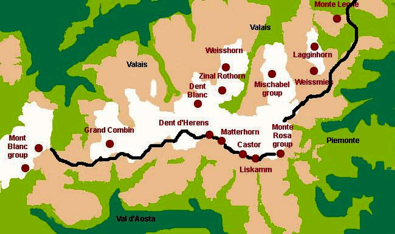
the whole range could be divided, for better understanding, into 3 sections :
western section
from col Ferret to the Tète Blanche :
south of the watershed
- in the big area between the Val Ferret, the G.S.Bernardo and the Val d'Aosta we have at least 2 groups, divided each other by the Comba di Vertosan.
- between the Valpelline and the Valtournanche we have at least 2 distinct groups, Cian and Chateau des Dames, another one should be the Faroma, but we can join them all in one big group
watershed - Velan and Testa di By can be considered as 1 group and, forgetting the Col du Sonadon we could also join them with the Grand Combin ... is very hard to join to them also the range Rayette-Blanchen-Collon that, geographically are well distinct each other
north of the watershed - Arolla-Chelion-Ruinette : the glacier d'Otemma is a good border for them :)
central section
from Tète Blanche to the Col del Lys
why the Tète Blanche ? ... easy ! That summit is the starting point of the big ridge going to Weisshorn and dividing the Val d'Herens and the Val de Zinal from the Mattertal (Zermatt), so, here we have,
north of the main watershed, 1 big ridge going toward NE, the Weisshorn group (starting with the Dent Blanche), all those ones that have made the high route Chamonix-Zermatt well know this key point
on the watershed - Dent d'Herens and Matterhorn can be considered a single group ... no crossing here till the Theodul Pass.
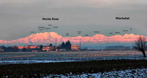
- no doubt about considering all in one the big Monte Rosa, from Theodul Pass till the Passo di Monte Moro as a unique group
south of the watershed ... there should be at least 3 more subgroups : - the Gran Tournalin, along the ridge descending toward south from the Gobba di Rollin and dividing the Val Tournanche (Cervinia) from the Val d'Ayas
- the Testa Grigia, descending from Castore toward south and dividing the Val d'Ayas from the Val di Gressoney
- the Corno Bianco range, descending from Pyramide Vincent and dividing the Val di Gressoney from the Valsesia
northern section
of the range is quite easy to be defined, ranges are well distinct by deep valleys and go down to the bottom of the Wallis ... so we can identify, here, the 2 main groups - Mischabel, between the Mattertal (W and S) and the Saastal (N and E)
- Weismiess, between the Saastal and Simplonpass valley
![]()
here we have the main groups :
Grande Rochere - Grand Golliaz group
Fallere group
Velan
Grand Combin
Gelè
Rayette
Ruinette-Chelion-Arolla
Collon - Tète Blanche
Weisshorn
Dent d'Herens - Matterhorn
Chateau des Dames group
Monte Rosa group
Grand Tournalin
Testa Grigia
Corno Bianco
Mischabel group
Monte Moro range
Weissmies group
Getting There
from Italy - south side - Val d'Aosta and Piemonte NE
from Switzerland - Wallis
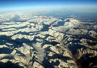
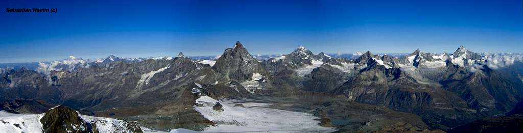
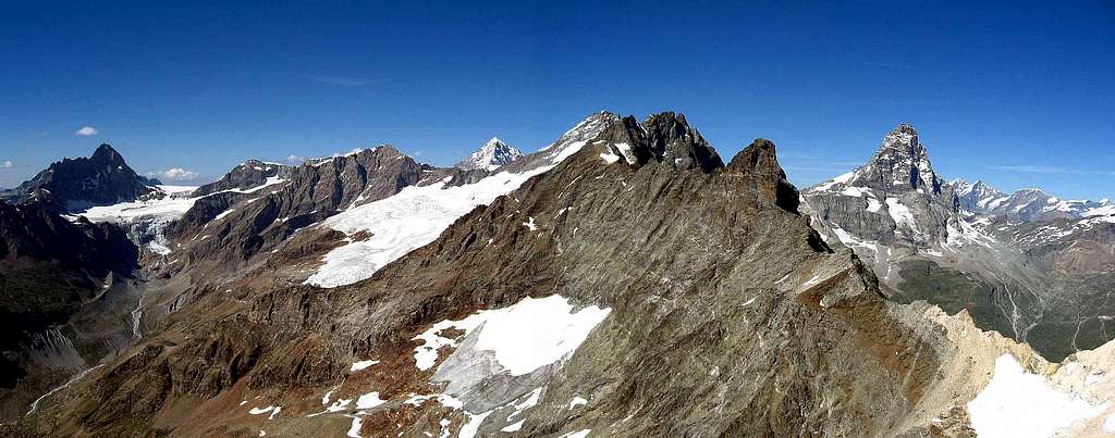
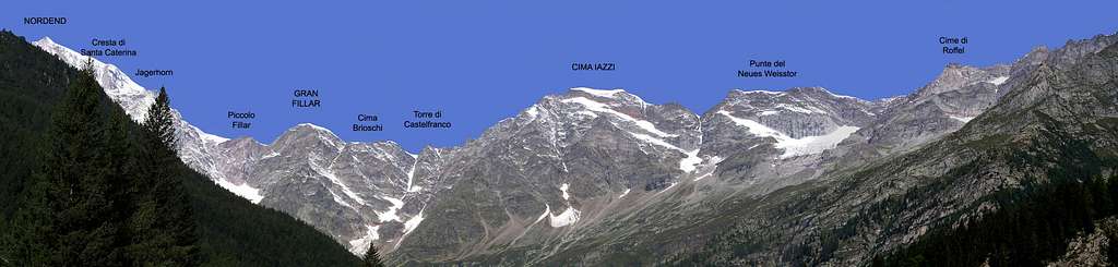
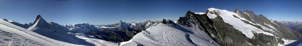
Labeled panos from the plane
Grande Rochere - Grand Golliaz group
first group of this main ridge is the Grand Golliaz
delimited by the Val Ferret (NW), the val del Gran S.Bernardo (E) and the Val d'Entremont (NE) with its main summits : - Grande Rochère (3326m)
- Gran Golliaz (3237m)
- Aiguille de Leisasse (3013m)
- Mont Fourchon (2902m)
- Pointe de Drône (2949m)
Fallere group
south of this first group, entirely belonging to Val d'Aosta, the
Fallere group
delimited by the Comba di Pianavalle (W), the main Val d'Aosta (S) and the valle del Gran San Bernardo (NE) with its main summits : - Testa di Serena (2830m)
- Fallère (3071m)
- Punta Leissé (2771m)
- Punta Valletta (2801m)
- Monte Rosso di Vertosan (2943m)
Velan group
East of Gran San Bernardo pass the ridge rises with the the huge massif of Velan
delimited by the Val del Gran San Bernardo (SW), the Val d'Entremont (NW), the Valpelline (S) and the Col du Sonadon (3504m) (N) - Mont Velan (3734m)
- Tète de By (3588m)
with a lot of minor summits rising upon its 4 ridges
Grand Combin
after (N) of the Grande Téte de By, entirely in Switzerland, the first very important group :
Grand Combin (4314m)
between the Val d'Entremont (W) and the Val de Bagnes (E)
Gelè group
the Fènetre Durand, on its SE ridge is the starting point of the group of Gelè
between the Fenétre Durand (W), the Val de Bagnes and the Glacièr d'Otemma (N), the Valpelline (SSE) and the Col de Créte Sèche (E) - Gelè (3518m)
- Becca di Faudery (3301m)
- Mont Morion (3487m)
- the rocky ridge, toward SE, of the Aroletta
- Mont Clapier (3434m)
- Punta Fiorio (3332m)
and many minor summits
Rayette group
toward East, on the main ridge, the group of Rayette
between the Glacier d'Otemma (NW) and the Valpelline (SE), ending to the Col d'Otemma - Rayette (3529m)
- Aouille Tseucca (3524m)
Ruinette - Chelion - Arolla
north of the Glacier d'Otemma, entirely in Switzerland, the important group of Ruinette-Chelion-Arolla - La Ruinette (3875m)
- Arolla (3796m)
- Cheilon (3870m)

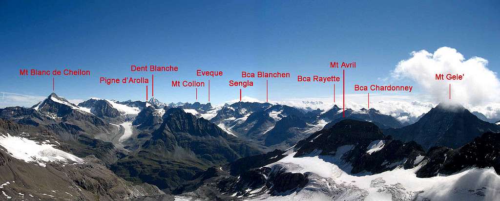
Collon - Tète Blanche
now, on the main watershed, the group Blanchen (3680m) - Collon (3637m)
then the main ridge goes toward west with the Mont Brulè (3691m) and arrives to the Tète Blanche (3724m)
Near the Mont Brulè the Punta Marcel Kurz (3496m) wherefrom starts the important ridge of Vannetta
Weisshorn group
herefrom, toward North the very important group of Weisshorn group
starting with the
- Dent Blanche (4356m)
- Obergabelhorn (4063m)
- Zinal- Rothorn (Moming) (4221m)
- Weisshorn (4506m), the king of the range,
followed by the last "4000" of the range, the - Bishorn (4153m)
Dent d'Herens - Matterhorn
while, toward west the ridge rises with the
- Dent d'Hèrens (4171m)
- Matterhorn - Cervino (4478m), the all over the world most famous summit
the ridge falls down to the Theodul Pass, the starting point of the big Monte Rosa Group.
Chateau des Dames group
From the Dent d'Herens, a ridge, toward South, hosts the remarkable summits of
- Grandes et Petites Murailles,
- Chateau des Dames,
- Cian,
- Redessau,
- Cima Bianca,
- Becca d'Aver,
- Becca de Luseney,
- Merlo and ends with the Faroma -Viou
Monte Rosa group
Starting from Theodul Pass the main watershed grows immediatly with the big massif of Monte Rosa
the first (secondary) summits toward East are the Klein Matterhon (3883m) and the Gobba di Rollin (3902m) then, going toward East,
- Breithorn (4161m) one of the most popoular mountains of the Alps, with its 4 summits
- Pollux (4092m) and Castor (4226m), the "twins"
Just East of these summits the first very important (twin) summit of the group, the - Liskamm (4527m).
East of them, after the Colle del Lys, the high massif of Monte Rosa (4634m) with its very high ridge hosting 9 summits over 4000m..
From the first of the 4 higher summits of M.Rosa, the Signalkuppe (Punta Gnifetti) the ridge goes down toward East with some "minor" summits: - Cima Tre Amici (3727m)
- Punta Grober (3497m)
wherefrom, toward East starts a long, secondary ridge starting with the - Pizzo Bianco (3215m)
while toward South another minor ridge hosting only one "important" mountain: the - Monte Tagliaferro (2964m)
After the "last" summit of M.Rosa, the Nordend, the ridge goes down to some "minor" summits: - Jagerhorn (3939m)
- Piccolo Fillar (3552m)
- Gran Fillar 3675m)
- Cima di Iazzi (3804m)
wherefrom starts another important group
Grand Tournalin
this range starts, toward south, from the Gobba di Rollin and goes down dividing the Val Tournanche (Cervinia) from the Val d'Ayas
- Monte Roisetta (3334m)
- Grand Tournalin (3379m)
- Petit Tournalin (3207m)
- Becca Trecare (3033m)
- Monte Zerbion (2772m)
Testa Grigia
descending from Castore toward south and dividing the Val d'Ayas from the Val di Gressoney
- Monte Bettaforca (2971m)
- Rothorn (3152m)
- Testa Grigia (Grauhaup) (3315m)
- Monte Pinter (3132m)
- Corno Vitello (3057m)
- Punta Valfredda (2944m)
- Punta Valnera (2754m)
Corno Bianco
this is a very important long ridge descending from Pyramide Vincent and dividing the Val di Gressoney from the Valsesia - it starts from the well known Col d'Olen (2881m)
- Corno Rosso (3023m)
- Punta di Straling (3115m)
- Corno Grosso (3042m)
- Corno Bianco (3320m)
- Punta delle Pisse (3020m)
- Punta della Croce (2615m)
and a very long ridge going down, with many minor summits, to the Alpi Biellesi
Mischabel
Mischabel group
that can be considered made by two parts, the southern one, lower and relatively flat that hosts the
- Strahlhorn (4190m)
- Rimpfischhorn (4199m)
- Allalinhorn (4027m)
- Alphubel (4206m)
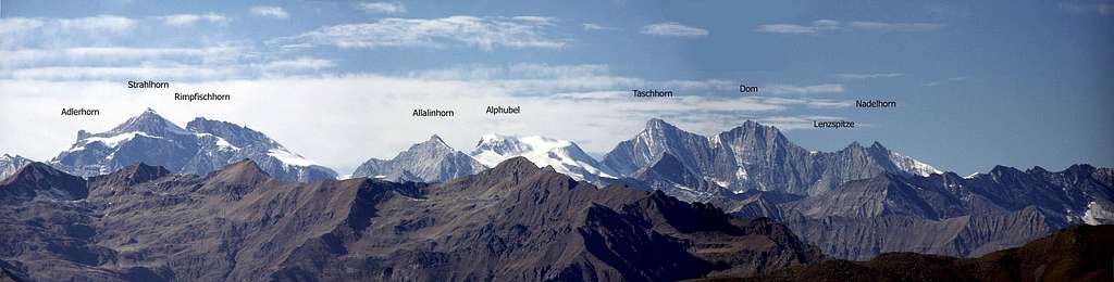
North of this ridge the higher part of the group with its huge steep summits:
- Taschhorn (4491m)
- Dom (4545m)
- Nadelgrat (4327m)
- Lenzspitze (4294m)
Monte Moro
Going back to the main watershed ... after the Cima di Iazzi the ridge goes down to the "Weisstor" (a pass joining the Findelengletscher and the Scwharzenberg gletscher) and turns toward East passing some fine but not important summits :
- Cime di Ròffel (3609-3589-3483m)
- Seewjinenhorn (3215m)
- Monte Moro (2988m)
- Joderhorn (3035m)
- Pizzo di Antigine (3192m)
- Punta di Saas (3193m)
that are like a crown around the sadly famous Mattmark lake
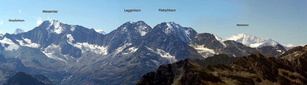
Weissmies
toward North starts a ridge, hosting 3 very fine summits :
Pizzo Bottarello (Sonnighorn) - 3487m - with its fine NE ridge (PD sup)
Pizzo di Loranco (Mittelruck) - 3363m - with its very fine (and famous) E ridge (Cresta del Lago Maggiore - D)
Pizzo di Andolla (Portjengrat) (3653m)
From this important hub the main ridge grows up again (toward N) over the 4000m with the Weissmies group
- Weissmies (4023m)
- Lagginhorn (4010m)
- Fletschorn (3993m)
now the ridge, with the "minor" but interesting summits of Sengchuppa (3665m) and Boshorn (3267m) ends near the Simplon Pass where the Alpi Pennine end
While, toward NE a secondary ridge, made of minor (but fine for hiking) summits, is the western border of two fine subvalleys of Ossola : the Valle Antrona and the Val Bognanco and ends down to the Val Divedro crossed by the road of the Simplon Pass.
When To Climb
It depends on summits and ranges. There are many good areas for ski-mountaineering.