
|
|
Area/Range |
|---|---|
|
|
31.9833°S / 70.1167°W |
|
|
Mountaineering |
|
|
21982 ft / 6700 m |
|
|
Introduction
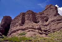
 Ramada from the south
The official name of the Mercedario group is Cordillera de la Ramada, but as few would find the page or the group under that name, I've choosen to use the more popular and well-known name. For many climbers the group is only known as "those high peaks in the north", looking from Aconcagua. Three peaks stands out from the others when looking at the massif from the south. Mercedario, clearly the highest and located most far away. La Mesa with its enormous snow fields and Ramada, the massive peak located in the foreground of the range.
The area still gets few visits from climbers, but the interest has grown a little bit during the last couple years. One reason I've heard is; some mountaineers want to get away from the crowds on Aconcagua and climb a peak which is almost as high, but located in a far less well explored area. The group isn't as easily reached as the higher neighbor, but the walk in is spectacular and a little adventure in itself.
Another attraction is the enormous south face of Mercedario. Technically speaking not so difficult, but the almost 2000m of constant snow climbing, which has to be done in one day makes sure also more experienced mountaineers find an interesting target. Pico Polacos, with its high technical level beckons for top notch climbers and there are still unclimbed routes on the peaks rock faces.
The normal routes on Mercedario, Ramada and Alma Negra offers nice alternatives for those who want to climb really high, but doesn't have the technical skills for the above mentioned alternatives. La Mesa and its huge glaciers is a seldom summited mountain with long ridge traverses and huge glaciers.
Mirador and Trabante are two smaller summits, which make fine alternatives for acclimatization on respective sides of Mercedario. Wanda and Negro are two peaks easiest climbed from the Paso Ancho pass, a flat, wide ridge which offers a natural barrier in between the north and the south side of Mercedario.
The two options to consider.
If you want to climb many peaks or/and the south face of Mercedario, you should head for Valle Colorado. If you want to go for the normal route on Mercedario and Trabante II, you should head for Las Molles and the northern approach.
Getting There
 Las Juntas bridge
Fly to wherever you live to Argentina and head for Mendoza or San Juan, the two capitals of the provinces with the same names. Take a bus to Barreal, a little sleepy town at the foot of the group. You may have to change bus in San Juan if departing from Mendoza.
When in Barreal, you contact one of the agencies which can arrange transport to the mountains. More about this in the Agencies Section.
Adventureous souls don't bother with this and walk north out of Barreal and walk right on the first turn-off towards the mountains and hitch. Expect a maximum of five cars a day. Water can be found in the large river on the right hand side of the road. Sometimes the distance to the river can be well over a km.
When in Las Juntas, you have a last chance to change your plan, as this is where the road splits in two. One towards the south face and Valle Colorado and one to Las Molles and the normal route.
 Rio Colorado
There are two options on how to walk to base camp.
1. With mules and/or with low water levels in Rio Colorado, you can cross the river at three places and walk on a good path all the way.
Hikerman99 adds:
The trail crosses the river 7 times. The trail starts on the right side of the river (looking upstream) at Santa Ana and crosses almost immeadiately. The hike in goes through an open area for a few miles before the canyon closes in. Eventually the trail crosses again, followed by 4 more crosses in a relatively short span of 2 or 3 hours of hiking. After the sixth cross, you will pass by a brilliant section of red rock the appears to be straight out of southern Utah. This marks the beginning of a difficult section where the canyon becomes much steeper and the "trail" becomes filled with loose rocks, slowing progress considerably. Eventually, the canyon opens up again and the trail crosses the river for a seventh and final time to the left side of the river. This begins the long final stretch where the views of the main peaks of the range begin to come into view. The straight-line distance according to GPS from Santa Ana to Pirca Polacos base camp is 15.25 miles, or about 25 km.
2. If there's a lot of water in the river and especially if you go without mules, you may have to walk all the way on the left hand side of the river. This is rough and hard and expect some hairy parts with steep scree and even some short passages with easy rock climbing, sometimes with quite a lot of exposure. Not recommended if you are heavily loaded.
If you go with mules or are a strong walker and choose alternative one, you can reach base camp "Campo de los Polacos" in a long day. 10-12 hours.
If you have to go for alternative two, expect two days to reach base camp. Three days if you aren't well acklimatized or want to take it easy. The first stretch is easy, followed by rough terrain and finally some easy walking again, when the valley opens up.
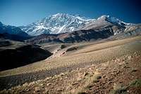
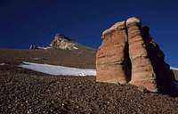
 Rock towers in Valle Colorado
Walk in via Las Molles
A huge flash flood hit the area in late 2005 and the road, along with the mining camp in Las Molles was swept away. This alternative is nowadays very hard and not recommended. Mulas can't go there and you have to carry everything yourself all the way to Mercedario. On top of that, there are some very hard sections of scrambling along the way and a guide who knows the area well is a must.
More about the Las Molles flash flood.
Trip report about the difficulty of walking in and out of the area since the flash flood hit.
The peaks
A list of the peaks of Cordillera de La Ramada. Go to respective peaks main page to find more information. Mercedario MercedarioMercedario - 6700m Routes |
 Ramada RamadaRamada - 6384m Routes |
 La Mesa La MesaLa Mesa - 6200m Routes |
 Alma Negra Alma NegraAlma Negra - 6110m Routes |
 Polacos PolacosPolacos - 5935m Routes |
 Negro NegroNegro - 5600m Routes |
 Trabante II Trabante IITrabante II - 5235m Routes |
 No image yet No image yetWanda - 5200m No page on Summitpost yet. Easiest climbed from the plateau close to Paso Ancho. Two photos from the summit. |
 Mirador MiradorMirador - 4800m No page on Summitpost yet. The black little rock peak in front of Mercedario's south face. |
| No image yet Peak 5700 No page on Summitpost yet. Routes |
Paso Ancho - linking the two sides of Mercedario
 Climbing Negro, on a paralell route to Paso Ancho
If you want to change objective or see the other side of this beautiful range, Paso Ancho is the alternative that link the 'two sides'. All directions given, starts from the south'Valle Colorado.
From base camp/Campo de Los Polacos walk straight over the river valley towards and obvious opening in the Negro ridge. Head up the steep scree slopes until they get less steep. There's a small spring here where you can fill up your water bottles.
The main horizon ridge is black/grey in color, the next below is red and the lowest one is yellow.
You have two alternatives.
1. Walk up to the gap in between the red and the yellow ridge and turn right. This route is less steep and is the most commonly used. There's a very clear and present danger of rock avalanches here so don't attempt this route if it has been raining!
In the end it joins alternative 2 (described below) and the final part is the same to the pass.
2. Look for guanacos trails before the yellow ridge. They are sometimes very steep and exposed. be very careful in some places. The route is obvious at most times and the trails are easy to find. Also, there's only one way up the connecting valleys.
After an exposed and very steep section, with possible penitentes fileds at about 4500m, you can see the pass and the ridge. Unfortunately you can also see traces of mud/sand/scree slides and rock avalanches. Pass this section as fast as you can and don't even consider going on if raining!
When you have passed the dangerous section under the rock towers and big boulders aim up towards the lowest point of the ridge.
A little cairn at the foot of some rock formations marks the Paso Ancho.
Walk towards the foot of Negro. Cross some penitentes fields and pass in between Negro and Wanda.
There are excellent cammp spots here.
Head for the left hand side of the valley and walk on a wide ridge until you see the valley on the other side. There are many slopes leading down to the mining road far below. Go for one which you find suitable. Guanacos trails will guide you. When on the road, you can see rivers with fresh water in the valley below. Either head down to the grassy fields further down or traverse straight over the ridges which finally takes you to the normal route of Mercedario.
If you go down all the way to the grassy fields, you'll loose about 300m of altitude (3700m). The road is at about 4000m, depending on where you hit it. The ridges you have to traverse is at about 4200m.
Expect a 10 hour day from base camp to the grassy fields on the other side. Don't take this traverse lightly. I would say it's harder, more exposed, filled with more objective danger and is more of a challenge than climbing Ramada and Mercedario.
Here's a trip report about Paso Ancho.
Agencies
 View from the summit of Wanda
There's one very good organizer in the area. Contact Anibal Maturano or Celste Arias at San Juan Aventura. They know the area like the back of their hands.
San Juan Aventura
Ruta 12 s-n Pasando Control Fitosanitario Zonda.
5401. SAN JUAN, ARGENTINA.
Ph: (+54) - 264 - 4945231
Mobile: (+54) 9 - 264 - 6711515
Fax: (+54) - 264 - 4945231
http://www.donmercedario.com.ar
NOTE: This web site sometimes doesn't perform well with Mozilla Firefox!
Expediciones Ossa (Barreal) can also arrange all details for Ramada.
Ramon Luis Ossa
Tel/Fax 0264-8441004
ossaexpediciones@infovia.com.ar
Casa Orviz can arrange everything for you from Mendoza. Transport, equipment, mules etc. This is by far the best gear shop in Mendoza.
Casa Orviz
Juan B Justo 532, 5500 Mendoza
Tel. 0054 261 4251281;
www.orviz.com
The Las Molles flash flood
The area is full of deep gorges and there has been at least one really large flash flood. Conditions can change dramatically and in the end of 2005 the trails, the road and even the entire mining camp at Las Molles was swept away. If the locals warn you about cut roads or an imminent danger of floodings, take it very seriously.Here's an article about the Las Molles flash flood.
A trip report about the difficulties of moving around in the area after the flash flood.
Camping
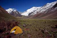 Camp near Mercedario's south face
Camp whereever you like in the area. There may be a permant base camp tent in Campo de Los Polacos during peak season. This is mainly set up for clients which has paid for this service.
Be careful not to camp too close to any of the rivers as the water levels can rise very quickly in the area.
Nature
 Rock formations on the walk in
The area is spectacular.
You start the approach in the desert area of Barreal, which is a little oasis town in a very dry area. In the distance you see the high snow capped peaks while traveling on dusty sand tracks. A narrow canyon with strange looking large boulders and a huge brown river will accompany you until you reach a zone with lots of multicolored rocks and some interest vegetation. Valle Colorado is full of colorful scenery as the rocks come in almost all colors and some formations are both dramatic and impressive. The clear Rio Colorado and the little vegetation that grows next to it looks like a little streak of life in the dry and almost dead surroundings.
All of a sudden Valle Colorado opens up and you're all of a sudden in a grassy valley with huge snowy peaks all around you. If you thought the colors were sharp of the walk in, you want be dissapointed walking towards Alma Negra and Ramada. They are evven sharper here. Red and yellow dominates.
On the northern side of Mercedario some glacial rivers give life to some areas of bright green meadows with lots of flowers. It's very different from the other side of the massif.
You will for sure see condors and guanacos in the area. The latter is a type of llama which scramble the scree filled mountain slopes with fantastic agility.
Permits
There is no peak fee or other permits, but you have to register at the gendarmeria in Barreal, located in the huge army compound in the center of the town. When crossing Rio de los Patos at Las Juntas, you also have to register or at least tell the guys at the river that you enter the area. 7 km up along Rio Colorado there's an gendarmeria check point in Santa Ana, there you also have to register.Climbing season
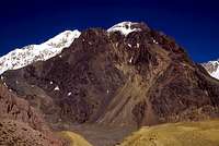
 Rock towers close to the summit of Alma Negra
For the snow and ice climbs, you better go early in the season. November and December is recommended for the south face of Mercedario, La Mesa and Pico Polacos. Also the direct couloir of Negro can be smart to attempt before the snow conditions transform to something bad.
The non-technical routes are better climbed a bit later. December through March are most common.
Water levels in the rivers are of great concern in this area, so make sure your organizer is updated on this. If you go there without, ask the military in Barreal, or later at Las Juntas bridge.
Guidebook and map
Summitpost member DoJo wrote the following (Posted Feb 24, 2013):New Guidebook + Map
Anibal Maturano published the guidebook: "Rutas del Mercedario" that covers (amongst others) the Ramada range and Ansilta range.
There is also a new map of the Ramada range available.
The book and the map are available in bookstores in Mendoza (I bought them in Nov. 2012)