
|
|
Area/Range |
|---|---|
|
|
39.23820°N / 106.1079°W |
|
|
Hiking, Mountaineering, Ice Climbing, Scrambling, Skiing |
|
|
Spring, Summer, Fall, Winter |
|
|
14200 ft / 4328 m |
|
|
Overview

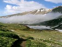
Horeshoe Mountain's glacial cirque.
This high mountain chain in the heart of Colorado lies between the Front Range to the east and the Sawatch Range to the west. Relatively off the beaten path, this range would see very little traffic if not for its several, popular Fourteeners. The Mosquitoes host 5 mountains that exceed the magic fourteen thousand foot mark, Mount Lincoln, Mount Bross, Mount Democrat, Cameron Point, and Mount Sherman. The range also boasts several more Centennial Thirteeners.
The Mosquito Range is in one of the driest and highest areas of Colorado, so the name is quite odd. Many features in the area have the name Mosquito, including a peak, a gulch, and a pass. One can only assume that a miner named these things and the reason has been lost to time. SP member Adempha adds this: "In volume III of Kenneth Jessen's Ghost Towns : Colorado Style, he refers to a township named Mosquito. Two other names had been taken when filing a request for a post office, and on the third attempt of filling out the form, there was a dead mosquito on the "name of township" line. While there's no evidence the range was directly named after the town, it's good urban legend..."
The Mosquito Range begins at the Tenmile Range's southern boundary, the Continental Divide, and it ends in the vicinity of Trout Creek Pass on US 24. Although the Tenmile and Mosquito ranges are geographically continuous, there are several geologic differences between the two ranges, mostly concerning the age of the mountains. So, the difference between these ranges are not merely in name - they are also geologically disparate, which I will address below.
One unfortunate aspect to these mountains is a current struggle between private landowners and those of us in the outdoor community. Although many of these mountains are on public land and have great access, several of the more popular mountains here have serious issues with trespassing and private property. Please read the section below concerning Access. Currently, the summits of the three Fourteeners in the range are closed to access.
Although this range has a reputation for easy climbs and big crowds, there are still plenty of places to get lost here and enjoy solitude. Read on, and hopefully I'll be able to introduce some fantastic climbs and areas that you haven't visited before.
Area History

The Dauntless Mine on Mount Sherman
"There's a deep, dark hole in the mountain
Where the devil sleeps all the time
Guarding his gold from the boys young and old
From the men who worked in the mine...
There's a deep, dark hole in the mountain
Where we shovel and pick every day
Stealin' his gold, yeah
The boys young and old
They're gone, but not far away..."
-"Not Far Away," Yonder Mountain String Band
Like most of Colorado, this region wasn't heavily settled until gold and other precious metals were discovered in the mountains. Long before white settlers arrived in the area, the Mosquito Range was an ancestral hunting ground for the nomadic Ute people. The mining boom of the 1850s brought white settlers here, and several Colorado mining towns emerged. On the east side of the mountains lie three historic towns: Fairplay, South Park, and Alma. On the west side is the famous town of Leadville. All three were settled mainly by miners and those who made their money from and around the miners.
If you've ever solo climbed in this range, it is likely that you've come upon an abandoned mine shack or structure. Especially when the wind is howling and there isn't another soul around for miles, even the most rational and logical person can't help but get a little weirded out considering the history here. It's simply amazing how the miners of those times lived at those high altitudes and mined in those dangerous shafts. A case in point is the mine shack on the summit of Horseshoe Mountain, at nearly 14,000 feet.

Fairplay
Fairplay sounds like it got its name from a nice story, but the history of the Wild West is seldom that way. In the mid-1800s, a man was riding toward the town when a man passed him riding hard and with a bullet hole in his cowboy hat. Puzzled, the rider continued on until he came upon a group of miners in a tent city. The rider asked the miners why the other gentlemen was racing away with a bullet hole in his hat. The miners replied that the man had come upon the camp, noticed that one of the miners was the man who had raped and killed his sister. As the stranger drew his gun, the other miners insisted that he not kill an unarmed man, but they should have a duel to settle the score. The duel commenced and the stranger killed the miner with a clean shot to the chest, while the miner merely put his bullet through the stranger's hat. The rider then asked if the town had a name, and the locals indicated that it did not. The rider quipped that they should call the town "Fairplay" since the locals seemed to insist on fair dealing - even in dealing death!
Today, Fairplay is a small mountain community on Route 24. It still hosts several yearly festivals and events that pay homage to its history. Visit Fairplay during the Mountain Man Festival or the annual Pack Burro Race for a taste of history.
South Park
People driving along US 24 to the mountains often remark, "South Park is a real place?" It certainly is - and don't try to find Cartman or Chef. You'll quickly notice that many of the buildings look very similar to the cartoons - Trey Parker and Matt Stone hail from Colorado, and based their irreverent cartoon on the old mining town adjacent to Fairplay.
South Park was designated as an actual town in 1957 after a Colorado Springs lawyer was prompted to do something to save the history of the area. The site for South Park was chosen as the area that had the most history, and the least vandalism and neglect. South Park City was born as you see it today. Artifacts were donated, buildings were moved, re-built, or restored. Museums were opened. Today 35 original buildings stand in tribute to that time and to the men and women who lived it. Fairplay's "ghost-town" recalls for the visitor, the romance of a by-gone era.
Alma
Although the reason for the town name of Alma has been lost to time, it can be reasonably inferred that it was named for a woman by the same name, since Alma was a popular woman's name at the time. Alma was settled in the mid-1800s and its claim to fame was Silver mining. At one time, Alma produced nearly 2 million dollars in silver annually, but in the late 1800s a smallpox epidemic nearly wiped the town out completely after some Mexicans drove a herd of sheep infected with the disease into nearby Buckskin Joe.
The smallpox epidemic created one of the most interesting ghost stories of the area. The virus spread throughout the whole town, but one resident, a "dancehall girl" named Silverheels, helped nurse many of the sick back to health. Eventually, she succumbed to the illness toward the end of the epidemic and the people took a collection of money to help her out. When they went to her house to give it to her, she had fled mysteriously never to be seen again. A nearby mountain is named Mt Silverheels in her honor. It is said that a veiled woman is often seen walking the Alma cemetery among the graves of smallpox victims. When approached, the figure vanishes into thin air, like the actual Silverheels.
Today, Alma is a mountain community with a year-round population. It sees many visitors annually and is one of the highest communities in America.
Leadville
The "Two Mile High City," Leadville has one of the most storied histories of any town in Colorado, and the American West overall. Leadville residents call their town the "center of Colorado history," and with good reason...
Gold and Silver
In the spring of 1860, prospectors discovered gold in what was to be called "California Gulch." Abe Lee, one of the prospectors who had dug just a little bit deeper than his companions screamed, "I've got all of California right here in my pan!". Instantly, thousands flocked to the valley for their share. There were at times more than 6,000 prospectors in the gulch, and before it was all said and done, roughly eight million dollars worth of gold was taken.
The Gold Rush only lasted about 6 years, and it was replaced in 1877 with one of the richest and most famous silver districts the world has ever seen. Leadville produced seven hundred million dollars of the precious metal.
Wars, Famous Visitors and Founders, and the Cloud City
By 1880, Leadville was the place to be in Colorado. Visitors included Susan B. Anthony, Oscar Wilde, Frank and Jesse James, Buffalo Bill, and Doc Holliday. Famous Founder Horace Tabor engaged in an infamous love triangle between his wife and "Baby Doe" Tabor, a young inhabitant of Leadville. Although Tabor served as a Senator and was a powerful man, his personal life became the stuff of legend in Colorado. An opera was written about the situation, and ironically, the Tabor Opera House still stands in Leadville today.
After the killings at the OK Corral, Doc Holliday came to Colorado to settle down into a peaceful life until one of his sworn enemies was seen in a local bar. Holliday attempted to kill the man before some miners subdued him. The Leadville public records still show the evidence of his arrest.
Leadville was also the site of unimaginable violence during its early days. The Lake County War, fought over land disputes, raged here for years. There was a famous murder of Judge Dyer, a man who tried to bring law and order to the area. Numerous stagecoach robberies occurred in the region. Indeed, Leadville did everything it could to reinforce the mythos of the "Wild West."
Today, Leadville is a rather bustling mountain community that has a large population.
Geology
The Mosquito Range mountains are faulted anticlines formed as part of the Sawatch Uplift during the Laramide orogeny approximately 65 million years ago. The mountains were originally contiguous with the higher Sawatch Range to the west but were separated during the formation of the rift valley at the headwaters of the Arkansas River approximately 35 million years ago. The range is comprised primarily of granite. The eastern flank of the range along the rim of South Park overlain by Paleozoic and Mesozoic sedimentary rocks. The northern end of the range was glaciated during Pleistocene time, forming U-shaped valleys in the canyons.
The Mosquito Fault
The western slope of the Mosquito Range harbors the scarp of the Mosquito Fault, a major north-striking post-Laramide normal fault forming the east shoulder of the Rio Grande Rift. This fault has accumulated nearly 30,000' of vertical movement since early Miocene time. The resulting rift sits between Fremont Pass (CO91, 11,318') and Tennessee Pass (CO 24, 10,404'). This event caused the main uplift of the Mosquito Range. The Tenmile Range, just to the north, is thought to also have been lifted by this fault, however later actions that did not affect the Mosquito Range acted to shape the Tenmile and give it a different character.
Rio Grande Rift and the Colorado Mineral Belt
The main reason that this mountain chain is so rife with mined precious metals is its location. The Mosquito Range stands on the east flank of the Rio Grande Rift and astride the Colorado Mineral Belt. The fault allowed intrusion from below, pushing and forming these metals into the chain. The Gore Range to the north is not astride the Colorado Mineral Belt, and thus has not received the mining that the Tenmile and Mosquito Ranges did.
Glaciation
The Gore Range to the north had much more glacier action than the Mosquito Range, and this accounts for the more craggy look to the Gores. It is unknown if the Tenmile and Mosquito Ranges were lower than the Gores at the time, but it is clear that the highest reaches of both the Gores and the Mosquitoes are very similar, having been formed in the same Pre-Cambrian event. One major glacial cirque was formed on Horseshoe Mountain (see photo).
The Great Divide
The Continental Divide inexplicably cuts east-west as it goes between the Tenmile and Mosquito Ranges on its way to the Front Range. This final distinction separates the two ranges. Forming the northern wall of South Park, the Divide crosses the ranges on Northstar Mountain. Although it is unknown why the Continental Divide crosses in this east-west manner, it is clear that a significant geologic event caused this move. The unknown event is also responsible for creating several distinct Front Range mountains, namely Boreas Mountain, Bald Mountain, and Mt Guyot.
Access
Mount Buckskin
Closures
The popular Fourteeners in the Mosquito Range are closed to access. Please read the information below from the Colorado Fourteeners Initiative, updated in December of 2007.
The following text is taken from the CFI Website.
ACCESS UPDATE - DECEMBER, 2007
Currently, access to Mounts Lincoln, Democrat and Bross is still officially closed. These mountains have the potential for extreme danger unless climbers use approved trails. Due to extensive mining on the peaks of these Fourteeners, the ground is riddled with partially collapsing mining prospect holes, shafts, and tunnels (stopes) that run underground. Some of these hazards are located only inches from the surface and pose a danger to anyone crossing over them, particularly in loose or unstable surfaces. Due to liability concerns about potentially collapsing stopes, open mine shafts, and recurring vandalism to their property, landowners decided to close public access to Lincoln, Democrat, and Bross in the summer of 2005, thus sparking a number of efforts made to re-gain access.
Meeting the landowners’ requests for signage and a well-delineated route may allow the peaks to be opened in 2008. However, access to the actual summit of Mount Bross will remain closed for some unknown period of time, as that parcel is owned by multiple individuals and records are poor, making contacting the landowners extremely difficult due to the complexities of finding them.
Please continue reading this article to find out more about what still needs to happen in order to reopen access to these peaks.
Working Toward a Solution
House Bill 1049, signed into law in March 2006, extends liability protections of Colorado’s Recreational Use Statute to owners of private land where “attractive nuisances” such as abandoned mines exist. In August 2006, the neighboring town of Alma leased 3,900 acres of private land from the landowners to provide further protection under the town’s governmental immunity. These efforts help greatly, but on-the-ground work remains in order to re-open access by completing a single sustainable trail. Multiple side trails and shortcuts must be closed, and various signs must be installed to keep hikers on one established route. A single route is also necessary to address resource damage and help protect several populations of rare or endangered plants that can be trampled by off-trail hikers.
What Has CFI Done So Far?
Planning and design efforts on the Lincoln, Democrat, and Bross loop were initiated by the Forest Service and CFI after the 2005 closure and were completed in 2007. In 2007, CFI seasonal staff installed most of the required signs along the designated trail. The National Forest Foundation awarded CFI a “Friends of the Forest” grant to sponsor a volunteer project on September 8th. The 31 volunteers included groups from the Mosquito Range Heritage Initiative (MRHI)and MWH Engineering in addition to other CFI volunteers, and a substantial amount of valuable trail and restoration projects was completed. MRHI and MWH Engineering also worked with CFI’s Adopt-a-Peak program on these peaks during the summer and will continue their involvement in 2008.
How You Can Help
1.Volunteer in 2008! CFI will host a number of weekend volunteer projects at Mounts Lincoln, Democrat, and Bross. Look in our Spring 2008 “The Fourteener” newsletter for opportunities to help with trail construction and restoration.
2.Respect private landowner rights. Landowners have the right to restrict public access when they see recurring problems with vandalism and trespassing. Stay on established trails, educate yourself about private property issues, stay away from old mine shafts, and do not remove or damage anything (mine buildings, signs, etc).
3.Donate to CFI. Your donations help CFI to fund trail crews, organize volunteer projects, and educate the public about Leave-No-Trace and alpine ecology – all core to our mission and greatly needed on the Lincoln, Democrat, and Bross effort.
4.Be patient. We’re working hard on these three peaks, but large-scale trail projects take time and funding to complete. In the meantime, respect the private landowners’ needs by enjoying the wide array of other accessible Fourteeners and high peaks in Colorado!
Please Respect the Closure
The many partners working on the trails are interested in making access to these Fourteeners available as soon as possible. The Forest Service, CFI, Colorado Mountain Club, Mosquito Range Heritage Initiative, and other interested groups have invested considerable time and energy on this process. While the access to several of these challenging peaks will soon be reestablished, the involved parties are reminding members of the public to obey all signs and stay on designated trails once hiking is allowed. These peaks are private property and it is the right of the property owners and the town of Alma to close down access if the spirit of the agreement, which is to view access as a privilege rather than a right, is violated. By staying on the trails and respecting the historic structures and private property, the public may be able to continue to enjoy the adventure and views of these mountains.
Safety Contact Numbers, Lodging, and Camping
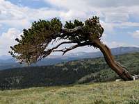
A Bristlecone Pine Tree
Safety Contact Numbers
Most of this range is within the Pike National Forest.
South Park Ranger District
320 Hwy. 285
P.O.B. 219
Fairplay, Colorado 80440
719-836-2031
Park County Contact Info:
County Office: (719)838-7509
Sheriff: (719)836-2494
As always, be observant of avalanche danger during Winter and Spring. Visit the Colorado Avalanche information Center's Website for current information.
Lodging
Lodging in the area is limited to the towns of Fairplay and Breckenridge. Cheaper lodging will be in Fairplay. For an interesting taste of history, try the Fairplay Hotel.
Camping
There are no formal campsites in the area with amenities, but informal camping at trailheads and within the Pike National Forest is abundant.
Mosquito Range "Must Do" Mountains and Routes

Skiing Mount Lincoln
The Decalibron - Decalibron
Decalibron means De(Democrat) Ca(Cameron Point) Li(Lincoln) Bro(Bross). Four Fourteeners in one easy day. Sure, it's crowded, but where else can you nail four 14ers this easily? A dream for the list-tickers.
Horseshoe Mountain - Northeast Ridge
This is an extremely easy route, but that's not the reason to do this one. This is one of the best ways to peer into the most geologically interesting feature in the Mosquito Range - Horseshoe Mountain's famous glacial cirque.
Mount Bross - Dolly Varden Gulch
This easy route is great for extreme trail running and mountain biking. It's also a very fun entry-level backcountry 14er ski in the Spring. The best part of this route is the Bristlecone Pine Scenic Area, a protected area with thousand-year-old Bristlecone Pines. Spend a few hours here - it's a photographer's dream spot.
Mount Lincoln - Putnam Gulch Ski Route
This great intermediate ski allows you to pole off the summit of Mount Lincoln and ski nearly 3000' to your car.
London Mountain - The Wave
Advanced ski descent on obscure London Mountain.
East and West Buffalo Peaks - Standard Routes
Great hike to two obscure Mosquito summits.
Buckskin Mountain - West Buckskin Snow Routes
These spring snow climbs and skis are really great for a quick outing. Park at Kite Lake and it's a mere 2000' up and down.
Mount Lincoln - Lincoln Ice!
The Mount Lincoln Icefall offers technical ice climbers several great lines.
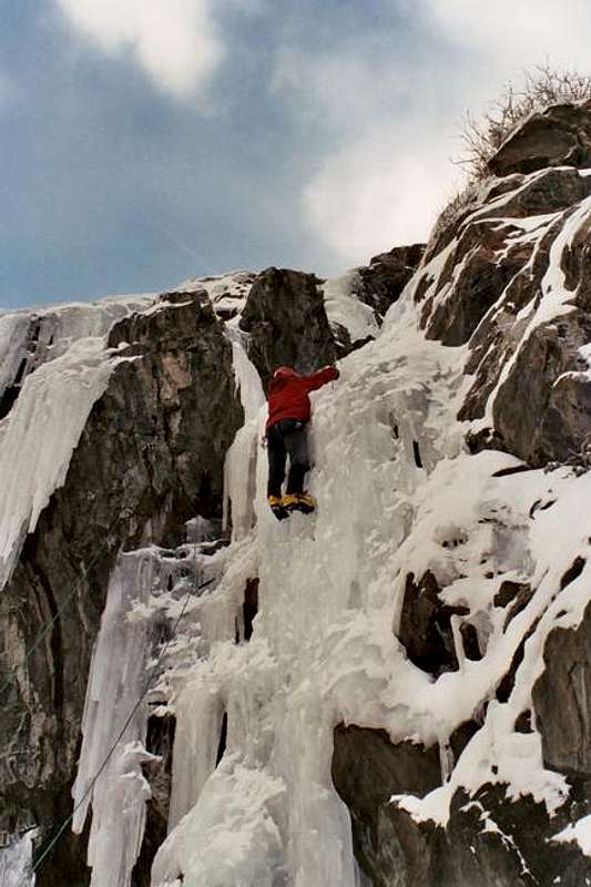
Mount Lincoln Ice
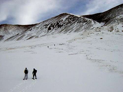
SP members climbing Mt Bross for the 2005 Rockies Gathering