
|
|
Area/Range |
|---|---|
|
|
39.36828°N / 72.69653°E |
|
|
Mountaineering |
|
|
Spring, Summer, Fall, Winter |
|
|
24590 ft / 7495 m |
|
|
Pamir - a brief overview
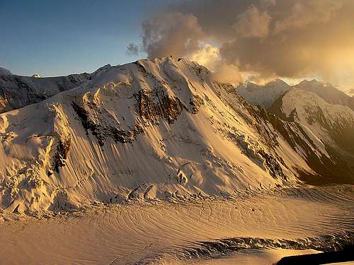
Pik Vorobiova (5691m)
The Pamirs is a big mountain group in Central Asia, covering large parts of Tajikistan and Kyrgyzstan where a majority of the higher peaks are situated. The range extends to Uzbekistan, Afghanistan and China. The range is very diverse and any kind of mountaineer and trekker can find something of interest here. The high alpine peaks attracts world class mountaineers from all over the world. Aksu and some other rock peaks are considered a test equal to for example Trango Towers and Pik Karla Marksa, Pik Tajikistan and Pik Engels in the Shakdhara Range have some of the hardest mixed routes you can find. Pleasent trekking and scrambling can be found all over the Pamirs.
Back in the times of the Soviet Union the peaks of the Pamirs were popular with climbers from countries of the "old Eastern block". The region has now gained a lot of popularity after the stabilization of the political situation in central Asia and because of the lack of high permit fees (100 $US at most).
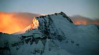
Pik Kommunizma at sunset
The Pamirs are sometimes refered to as the "knot" or the axis, as from the Pamirs other mountain ranges extend - the Pamiro Alai and Fan Mountains to the west, the Tien Shan to the north-east, the and Kunlun Shan to the east, the Karakoram to the south-east, and the Hindukush to the south.
The range is a result of the collision Indian-Eurasia. The deformation caused by that spread into the interior of Eurasia (Central Asia, Tibet, e.g.), causing the uplifting of major 7000 m+ ranges such as the Pamirs, Karakoram, Himalayas, Kunlun Shan, Tien Shan and Hindukush. Associated with this process and the related fault systems are massive earthquakes in the region.
Some include the Kongur Shan (Kongur Tagh, Kongur Tiube etc), Muztagh Ata Shan (Muztagh Ata, Koskulak etc. and Chakragil/Karabekter/Kingata Shan as a sub group to the Pamirs. They are all separate sub systems to a larger system and the most correct is probably to sort them all under Pamir. As I have gotten the impression most people search for these peaks under Kunlun, I have chosen to include them all on that page instead of this one.
Main sub ranges and peaks
Tajik/Afghani Pamir
Better known sub ranges include:
- Trans Alai Range - Pik Lenina, Pik Marshala Zhukova - alpine climbing - Tajikistan/Kyrgyzstan - Map.
- Academy of Science Range - Pik Kommunizma, Pik Korzhenevskoj, Pik Russia, Pik Revolution, Pik 26 Bakinskikh Kommisarov - alpine climbing - Tajikistan - Map 1 - Map 2.
- Shakdhara Range - Pik Karla Marxa, 6723m, Pik Tajikistan 6565m and Pik Engels, 6510m - very hard alpine and rock climbing - Tajikistan - Map.
- Wakhan Range - highest peak Koh-e-Pamir, 6320m - alpine climbing - Afghanistan.
- Pamiro Alai - which includes the sub-range Fan/Fann/Fanskiye mountains - Pik Aksu 5355m, Pik Alexander Blok 5239, Pik Chimtorga 5480m and Pik Piramidalnyi 5510m - world famous hard big wall/rock routes - Tajikistan and Uzbekistan - Map.
The highest peaks in the Pamirs are: - Pik Kommunizma 7495m - Tajikistan.
- Pik Lenin 7134m - Tajikistan/Kyrgyzstan.
- Pik Korzhenevskoj 7105m - Tajikistan.
- Pik Revolution 6974m or 6940m (depending on map) - Tajikistan.
- Pik Russia 6882m - Tajikistan.
- Pik 26 Bakinskikh Kommisarov 6842m - Tajikistan.
The names of the peaks
A lot of things has happened in the former Soviet republics in Central Asia lately. The new regimes have gotten rid of many "communist related" names and whole cities and areas have been re-named. The mountain's names is not exception. Unfortunately, some of the peaks have been given more than one new name and there’s a lot of confusion what the new official names really are. I have therefore choosen to use the old, well known names of all the peaks to avoid confusion.![Karla Marksa]()
Pik Karla Marksa
The only name that has won some general acceptance is Ismoil Somoni, which is the new proposed name for Pik Kommunizma. Still, the name is controversial as some ethnical minorities in Tajikistan has difficulties with the it. Their name of preference is Pik Garmo as it has no ethnical connotations. Other new names are high-level controversial and has created some national pride issues. Here's a good example; The Tajik government has re-named Pik Lenin and calls it Abu Ali Ibni Sino. The Kyrgyz counterpart calls the mountain Peak Sary Tash. Most alpinist clubs in Kyrgyzstan still calls the peak Pik Lenin, but their proposal for a new name is Peak Kaufman.
As it is a border peak, the guess is the peak will have two names.
The bottom line:
As the peaks are well known by the old communist names, it'll take some time before the new proposed names will win acceptance.The Snow Leopard Trophy
In the old Soviet Union times, one alpinist goal had a very high significance; to climb all Soviet peaks over 7000 meters. Those who managed to summit the five Central Asian giants could claim to be an elite mountaineer and take a place on the short list of high altitude climbers who had endured the ultimate test within the country's borders.![Peak Korzhenevskoy, common...]()
Pik Korzhenevskoj
Also after the fall of the Soviet Union the Snow Leopard Trophy is of great significance and accomplished climbers from all over the world are attempting to ascend the five highest summits of "the Russian part" of Central Asia.
Three of the Snow Leopard summits are located in the Pamirs;
Pik Kommunizma, Pik Lenin and Pik Korzhenevskoj.
The other two, Pik Pobeda and Khan Tengri are located in the Tian Shan north of the Pamirs.
For more info about the Snow Leopard peaks, please visit this page.Getting there
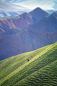
The obvious choice of transport is by air.![A lone donkey grazing on a...]()
Green Kyrgyzstan
All the capitals in Central Asia is served with pretty good connections from Europe and the rest of Asia. The airports with most traffic is those in Tashkent (Uzbekistan) and Bishkek (Kyrgyzstan). You can also fly to Dushanbe, but flights are much less frequent. Almaty, the capital of Kazakhstan is another alternative.
Of course there are many overland alternatives, but they are too many and complicated to describe here. One frequently used way of arrival deserves to be mentioned here though; arriving overland from China. You can either go over the Torugurt Pass or Irkestam. The former has good connections and the road is ok, but it goes through a military zone on the Chinese side and has to be planned well ahead. Any travel agency on either side of the border can take care of the arrangements. Irkestam on the other hand is completely hassle free in terms of red tape and it'll give you direct access to the Pik Lenin area. The road is really bad though, but road construction and upgrading is under way.Getting around
Pre arranged travel![Harry Journey!]()
Harry journey!
Expedition outfitters and travel companies offers conveniant rides to the most well known peaks on a standard basis. They can also help you out with transport to the more remote areas, but it tends to get quite expensive. Mini buses is the most common way of travelling, but in some parts old Russian terrain vehicles are used.
Local transport
It's a much cheaper way of travelling, but it can be taxing. Over crowded mini buses is the norm in the more mountainous areas. On the main asphalted roads regular buses is a good alternative. Expect long travel times and frequent stops. Departure times can be very erratic.
Hitchhiking
It's very easy to hitch around all the Pamir countries. In the desolate areas, basically all vehicles stop. Sometimes you're expected to pay a bit for the ride. Make sure you and the driver have the same idea about the price before hopping into the vehicle.
Cycling
For the independent traveller cycling is a very good alternative. A beautiful country side, fantastic scenery and challenging cycling has made Kyrgyzstan and Tajikistan a popular place for cyclists.
Walking
Where there are no roads, you have to walk. In the more remote areas walk-ins on foot is the norm. Even if there's a lot of horses in Kyrgyzstan, I've not seen them to be used by foreign climbers for riding. At Pik Lenin mules and horses are sometimes used for gear transport.Access & popularity
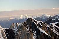
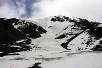
The Pamirs are in most parts quite inaccessible - due to deep valleys and steep mountains, glaciers, uninhabited areas and the lack of infrastructure.![Trans Alai peaks]()
Trans Alai peaks
Exceptions are the popular 7000m peaks Pik Kommunizma, Pik Korzhenevskaya and Pik Lenin. The former two can be reached by helicopter (hiking in is very long and complicated, especially to Pik Korzhenevskoj) and Pik Lenin's north (Kyrgyz) side is easily accessible with 4WD. The south/Tajik side is very remote, generally harder and seldomly climbed.
Many other of high peaks are usually complicated to access, notably the ones in the interior of Tajikistan. The access situation became worse after the breakdown of the USSR, which also left many former base camps abandoned and sans heli-access.
The nice exceptions are some high peaks located close to the Pamir Highway. They can easily be reached on small dirt tracks with a 4x4 or by a short walk in.
The remote sub-7000 m peaks hardly see any visitors. Intrepid Russian climbers and trekkers sometimes stray into the outback of the Pamir, but "westerners" is a rare sight beyond the Snow Leopard mountains.
By far the most popular peak to climb is Pik Lenin. It has a reputation to be the easiest 7000m mountain (in fierce competition with Muztagh Ata) and may climbers use it as a stepping stone for a first try on an 8000m peak.
A good second is Pik Kommunizma, the of all in Central Asia. The third Snow Leopard/7000m peak, Pik Korzhenevskoj is also a popular target.
After these three peaks it's hard to find the next contender on the popularity list. The severly difficult rock climbing peak Aksu attract a lot of hard core climbers and so it's an educated guess it takes fourth place. Some trekking peaks in the Fan Mountains see more visitors every year and the increased stability in Tajikistan will probably attract more trekkers to this area.
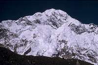
Red Tape
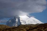
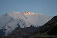
Visas![Last rays of the sun]()
Pik Lenin at sunset
Kyrgyzstan has dropped the visa requirement for many nationals and visas are available at the Manas international airport in Bishkek. Arriving overland, you still have to get a visa prior to arrival, but it’s easy to get from a Kyrgyz embassy.
Tajikistan requires visas by almost all nationals and it has to be picked up before arriving in the country. At some embassies a letter of introduction/recommendation is also necessary.
China visa procedures are nowadyas very straight forward and you can pick up a visa in a 1-3 days in any Chinese embassy.
Afghanistan was a difficult country to get a visa for until recently, but nowadays visas are readily available in a short time for a small fee in the country's embassies.
Uzbekistan's policy of handing out visas is both time consuming and expensive, as well as unpredictable. Some nationals have a hard time to get a visa at all. A letter of recommendation is usually a must. Sometimes a sponsor in the country is needed and the Uzbek representatives are usually trying to push you to buy a tour group deal.
Remember; the rules for getting a visa can be very different depending on which country you are from. A national from country X may get a free visa at the airport, but a person from country Z may have to apply months in advance and pay a lot of money for it.
Transit visas are usually quite easy to get. Extensions can be tricky and make sure you check out the rules about this before heading off for the mountains.
![Pik Dzersinskij s long south ridge]()
Pik Dzersinskij south ridge
Embassy list - Kyrgyzstan
- Tajikistan
- Uzbekistan
- China
- Afghanistan
- Kazakhstan
Permits - A Kyrgyz border zone permit can be picked up by any travel agency in Osh or Bishkek.
- A Tajik Gorno-Badakhshan Autonomous Oblast (province) permit is available in Dushanbe only. The ecological preservation fee also has to be paid for in the capital of Tajikistan.
- Climbing permits in Tajikistan is $100 and it's the standard fee for every peak over 5500m. Exceptions are made if you climb more peaks in the same area.
- The registration at OVIR is dropped, but be careful with this in Uzbekistan.
- Travelling from China over the Torugurt Pass requires you to travel with a pre-arranged jeep, with an governmentally aknowledged agency.
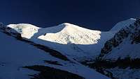
When to climb
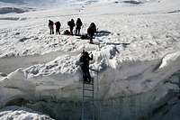
A huge majority of climbers prefer to climb in the normal season when the conditions are optimal. Late June to mid September is the recommended time and peak season is in the end of July to mid August. Going in the beginning of the period sometimes mean you have to battle deep snow and do more trail breaking. Going late, the crevasses have opened up more, it gets colder by the day and you may experience one of the infamous fall storms.![Ladder over crevasse]()
Climber in the icefall of Pik Lenin
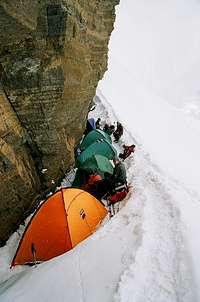
Some hardcore attempt the peaks in winter, but that's for die hards and elite only. Expect to bring all the gear you would bring for an 8000 meter peak or the polar areas. In the off season there are no facilities at the base camps and the passes on the roads can be blocked by snow, so you may have a hard time just reaching the peak.Camping
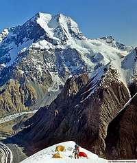
There are good season-permanent base camps with all the facilities you can possibly want at the three Snow Leopard peaks (Pik Kommunizma, Pik Lenin and Pik Korzhenevskoj).![Camp in central Pamir]()
Camp in central Pamir
You can rent a place in two person tents, eat food in the tent restaurants, buy provisions (incl. expensive gas canisters), rent guides and porters. These camps are very well organized and usually you have a choice of many company's services. You can pitch your tent anywhere outside these organized camp spots or make a deal with the organizing part and put inside there camp for a small fee, even if you're not part of a package deal. This can be a smart thing to do as there are quite a lot of theft from the tents at the Pik Lenin BC.
I have camped all over the Pamirs. Close to roads and villages and in the wilderness and have never experienced any serious problems. If camping close to a settlement it may be a good idea to ask the locals if it's ok to pitch a tent. If you're not hiding your tent, expect curious visitors. Usually not a problem, but I have at several occassions had visitors who wanted me to drink vodka and they have been very pushy about the issue, so it may be a good idea to hide your tent a bit, unless you're into testing your drinking abilities with the locals.
There are still some old Soviet time alpinist centers scattered all over the Pamirs, but I'm a bit uncertain about how many of them are still up and running.
If you have any info about this, please drop me a note.
Pamir peaks on Summitpost
Peaks with their own pages on Summitpost
Note!
The photo is linked to a larger version of the photo.
The link below the photo is linked to the mountain's page.
Peaks with photos only
If you have photos of other peaks in the Pamir, please attach them to the page!
![Up the north face of Pik Razdelnaya]()
Pik Razdelnaya![Pik Engels north face]()
Pik Engels![Kurumdy]()
Kurumdy![Pik 19 th Party Conference]()
Pik 19'th Party Conference
![Karla Marksa]()
Pik Karla Marksa![Pik Dzersinskij]()
Pik Dzersinskij![A massive avalanche comes...]()
Pik MoskvaRoutes
![Camp 5800 is located under...]()
High camp
SP member Vladimir Kopylov has made a lot of good sketches of routes.
Routes on the Snow Leopard Peaks - Pik Lenin – North face
- Pik Korjenevskoy – South Side
- Pik Kommunizma – North side
- Pik Kommunizma – West side
- Pik Kommunizma – SW (incl. Pik Russia)
Routes on other peaks - Asan - NW face
- Chapdara - NW face
- Pik 4810 - NW face
- Zamin Karor (1'st west peak) - NE face
- Aksu - North face
- Pik Russia - SE face
- Pik A Block - North face
- Pik Karla Marksa - North face
- Pik Mirali & Pik Maria - Northern routes
- Pik Admiraliteets - 6A "along the pillar"
- Iskander group
- Iskander north
- Iskander & Petrogradets
- Pik Engels - East face
- Pik IGU (Tajik State University) - East face
- Pik Revolution - NW face
- Chiurlionisa - SW
- Danilaytisa - West
- Pik Engels - Both peaks from the south
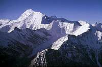
Maps & books
Maps![Pik Engels and Pik Karl Marx]()
Pik Engels & Pik Karla Marksa - Pamiro Alai
- South-west Pamir, Karla Marksa area
- Pik Revolution area
- Pik Kommunizma area
- Pik Lenin area
- The Shakdara Range
- Fann/Fanskiye mountains
- A good overview map
- Lots of links to maps on this page
Books
Kopylov has written a book called Forbidden Mountains - The most beautiful Mountains of Russia and Central Asia. - References for Peak Lenin
A close to complete list of books that includes Pik Lenin.External links
Wikipedia on Central Asia - an overview of the region![Low start of overweighted...]()
Heli transport in the Pamir - Asan, Pik 4810, Pik Slesova and some other tough rock climbing peaks
- Short info on the Fanskiye Range
- Aksu! Do I have to say more?
- General introduction to the Pamirs on Risk. Links further to the big peaks.
- Zamin Karor climb
- Speed championship in the Fanskiye mountains
- Climbing tale about the Aksu region
- The first ascent of the NE face of Pik Engels
- Aksu region overview
- Climbing Pik Engels In Russian.
- Traversing large parts of the Shakdara Range including Pik Karla Marksa. In Russian.
- A page with a lot of good info about Pik Lenin In Russian.
- Polish site about Pik 4810 and other peaks in the area. In Polish.
- Some nice photos of some Pamiri Peaks
- A commercial organizer's site about the Fann Mountains
- A site about Pik Mayakovskij. In German.
- A French expedition to Pik Karla Marksa. In French.
- Pamir 2008 - Pik Karla Marksa A Czech expedition to the peak. In Czech. Nice photos.


Rybakov - Mar 5, 2006 2:43 am - Hasn't voted
NameThe name of Pik Kommunizma is still a very hot debate in Tajikistan. It has become political issue of ethnical importance. Garmo vs. Ismail Somoni (also Ismoil Somoni). The Tajik population wants IS, but many others want Garmo. Most still say Kommunizma because it doesn't imply any ethnical issues, even if K brings back memories not everyone likes. The name battle will go on.
Ski Mountaineer - Mar 5, 2006 7:03 pm - Voted 10/10
Re: NameHi! I chose to name it "Pik Ismoil Somoni/Pik Kommunizma" to have both names used equally. For me Pik Garmo is a seperate peak (once thought to be the same peak as Pik IS/Kommunizma) of 6602 m elevation south of Pik IS/Kommunizma.
BigLee - Oct 28, 2006 10:50 am - Voted 10/10
What are these peaks?Have added a photo I took in Pakistan of the peaks I saw immediately north of the Wakhan coridor. No idea of their names. Maybe you know? You can delete the photo from the page if you don't want it! Lee
Corax - Oct 29, 2006 10:51 am - Hasn't voted
Re: What are these peaks?I have no clue of the names of those peaks. The shapes are not familiar either. There are so many peaks around there and somehow I tend to look for the bigger ones and the smaller ones just "drown" amongst the others and are not remembered. I guess we can find the names of some of them, if we have the accurate position of the place from where you shot the photo. The photo will stay on the Pamir page. I like it.