

-
 132233 Hits
-
 99.62% Score
-
 123 Votes
|
|
Area/Range |
|---|---|
|
|
40.30000°N / 105.7°W |
|
|
Hiking, Mountaineering, Trad Climbing, Bouldering, Ice Climbing, Aid Climbing, Big Wall, Mixed, Scrambling, Skiing |
|
|
Spring, Summer, Fall, Winter |
|
|
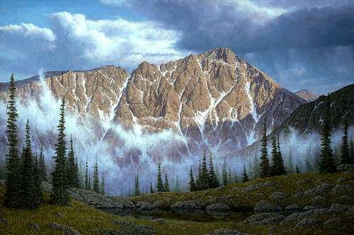
Original oil painting by Mountain Jim
Introduction
It’s an hour drive from my house to the entrance Rocky Mountain National Park. More than 2,000,000 other people can make the same claim, making RMNP one of the most accessible National Parks in the system. To many, this is a reason to avoid the place. In the summer it’s true that you won’t find a parking space anywhere after 9:00 AM, backcountry sites are booked long ago, the major trails are crowded with tourists, and climbing the standard route on Longs Peak is more of a social event than a wilderness experience.
To hiker and climber, however, RMNP has whatever you want: gentle peak bagging, superb rock climbing, exquisite mixed alpine routes, ski mountaineering, long traverses that will kick your butt, and anything in between. There are even a few small glaciers that occasionally sprout crevasses! A spectacular wilderness of rugged beauty is your backdrop. You can spend days or weeks wandering the backcountry, or just a day on an exciting climb and be back in town in time for beers and dinner.
I consider myself lucky to live near Rocky Mountain National Park.
History
"We stood on the mountain looking down at the headwaters of Little Thompson Creek, where the Park spread out before us. No words could describe our surprise, wonder and joy at beholding such an unexpected sight"
- Milton Estes on the discovery of Estes Park, October, 1859
Not surprisingly, the history of RMNP mirrors the history of the American West: native population living on the land, the coming of the white man as explorer, hunter, rancher, farmer, miner, businessman, and ultimately, recreationer. Throughout it all, especially in the last century and continuing in full force today, is the constant tension between development and preservation, between parks as playgrounds and parks as preserves.
Most of this information was gleaned from the very readable book, Rocky Mountain National Park - A History by Curt Buchholtz, available at that link from the Rocky Mountain Nature Association. Further information was taken from the excellent and highly recommended High Country Names by Louisa Arps and Elinor Kingery, recounts how most features in Rocky Mountain National Park and the Indian Peaks Wilderness were named. It appears to be out of print, but copies are available at Amazon and ABE.
Finally I have a copy of a wonderful booklet Mountaineering in the Rocky Mountain National Park, compiled by Roger W. Toll, a charter member of the Colorado Mountain Club and superintendent of RMNP (mentioned below). The book was published in paperback in 1921 by the Government Printing Office in Washington. I obtained my copy on Ebay, and leave it as exercise for those interested to search the web. Toll writes, in timeless fashion, "Whatever it's kind and degree, mountaineering is the vacation experience which, above all others, fits man and woman to return to life's toils and problems with perspective, endurance and steady nerve." At other times his writing is delightfully quaint. For example, when discussing how to waterproof boots he notes that "Several specially prepared oils are on the market, but bacon fat, lard or axle grease may be used." Ah, men were men back then!
| 10,000 B.C. | Native tribes were using Trail Ridge to travel between hunting grounds on the plains to the east and Middle Park to the west, as indicated by Clovis and Folsom points discovered in the Park What beauty or terror did the mountains hold for these people? |
| 5,000 B.C. | Evidence exists of semi-permanent hunting camps established in Front Range mountain valleys. |
| 3.500 B.C. | Low stone wall "game drive systems" are constructed in the mountains, one of which remains near Trail Ridge Road. Hunters could force prey, such as sheep, elk, deer, or goat, along the walls and into the range of men with spears. |
| 500 A.D. | The bow and arrow is introduced to the region, and the first traces of pottery appear. Little recorded history until the white man arrives. |
| 1820 | Major Stephen H. Long leads an expedition that explores the plains of the Front Range. He writes that "a high Peake was plainly to be distinguished towering above all the others as far as the sight extended". Until then this peak and its sister were known as the The Two Guides by Indians who used them as reference points. French trappers called the peaks Les Deux Orilles, The Two Ears. Now, of course, they are called Longs and Meeker. |
| 1843 | Fur trader Rufus B. Sage enters and becomes the first person to write of a high mountain park near Longs Peak, "What a charming retreat for some of the world-hating literati! He might here hold daily converse with himself, Nature, and his God, far removed from the annoyance of man." |
| 1859 | A Colorado "59'er", Joel Estes, drawn to the region looking for gold, settles in the valley described by Sage. He and his family stay for six years, ranching and hunting for a living. Estes Park would soon have a name. |
| 1864 | Joel Estes is visited by newspaperman William Byers of the Rocky Mountain News, who makes an unsuccessful attempt to climb Longs Peak. He does summit Mount Meeker, and publishes glowing reports of the region in his newspaper. |
| 1865 | Novelist Jules Verne uses Longs Peak as the site of a astronomical observatory for his book From the Earth to the Moon. |
| 1868 | Byers returns to Longs Peak, and with John Wesley Powell, L.W. Keplinger, and others, makes the first well-documented ascent. Powell predicts that this "hitherto been deemed impossible" feat would be surpassed by greater achievements. The following year he began his momentous journey down the Grand Canyon. |
| 1871 | The age of geologic exploration of the American West. Clarence King's Fortieth Parallel Survey enters Estes park. Among them is Henry Adams, a descendant of presidents, who adds to the glowing descriptions of the the region in print. The Survey climbs climbs many peaks and produces the first detailed maps. In August the Reverend Elkanah Lamb climbs Longs Peak via the Keyhole, then descends the unexplored east face! He loses his footing on Mills Glacier and amazingly manages to arrest his fall by grabbing a rock. Mills Glacier is now generally known as Lambs Slide. |
| 1873 | James Gardner of the Hayden Survey continues the government exploration. They carry scientific instruments to the summit of Longs Peak. Anna Dickenson, the first woman the make the ascent, is with them. She had climbed Mount Washington in New Hampshire 26 times, and the name Lady Washington is given to one of Longs' satellite peaks. This expedition also includes photographer William Henry Jackson, whose superb images capture the beauty of the Rocky Mountains. |
| 1873 | A British aristocrat, the Earl of Dunraven, leads a hunting group into Estes Park and stays. He writes, "The air is scented with the sweet-smelling sap of pines, whose branches welcome many feathered visitors from southern climes, ... The climate is health-giving ... so delightful that none can appreciate it except those who have had the good fortune to experience it themselves". The Earl forms the Estes park Company, Ltd, and attempts to buy up the entire valley, using legally dubious schemes. By 1880 he owns or controls 15,000 acres. Whether he intended this as a private hunting preserve or as a cattle ranch remains unclear, but his plans are thwarted as more settlers arrive. |
| 1873 | Isabella Bird arrives and is guided up Longs Peak by Rocky Mountain Jim Nugent, camping in what is now called Jim's Grove. In her best-selling book A Lady's Life in the Rocky Mountains she writes that Jim "dragged me up, like a bale of good, by sheer force of muscle". The following year Jim is killed in a gunfight with one of Dunraven's ranchers. The details of the incident remain in dispute. |
| 1875 | An influx of more homesteaders includes Abner Sprague, Alexander MacGregor, and Elkanah Lamb, whose names are familiar in the Park today. Lamb and his son Carlyle begin the first Longs Peak guide service, taking clients up for five dollars. They are all opposed to Dunraven's scheme to control the valley. |
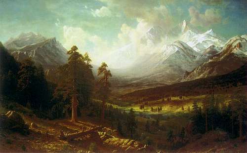
| 1876 | Colorado enters the United States as the 38th state. Dunraven hires artist Alfred Bierstadt to paint a large landscape of Estes Park and Longs Peak. He pays Bierstadt $15,000 and the painting is sent to Dunraven Castle in Wales. Today it is owned by the Denver Public Library. |
| 1877 | Using Bierstadt's advice for the location, Dunraven opens the Estes Park Hotel, his plans for a private hunting reserve having failed. The hotel is known locally as the English Hotel. |
| 1878 | Tourists and recreational campers begin to arrive in Estes Park. Among them are Carrie Strahorn who writes in her book Fifteen Thousand Miles by Stage that Estes is "a veritable Eden ... the sun never shown more brilliantly, the flowers never blossomed more beautifully, and the waters never chanted more hypnotic music, all luring us to stay". She is not the last to feel that way. |
| 1879 | The mining boom finds it's way to these mountains, especially in the Rabbit Ear Range, now known as the Never Summer Range. The village of Grand La ke is formed to support the n eeds of the miners |
| 1880-1890 | Mining reaches its peak during this decade with the town of Lulu City booming for 3 years along the headwaters of the Colorado River. The town includes a butcher shop, real estate agency, a hotel, barber shop, general stores, and of course, a liquor store or two. However the ore is of poor quality, and the inevitable bust soon follows. |
| 1885 | Homesteader Enos Mills arrives. He, more than anyone else, will influence the future of these mountains. He begins working as a guide for Carlyle Lamb and makes the first of his 250 ascents of Longs Peak. |
| 1886-1888 | Writer Frederick Chapin comes to Estes Park for seasons of mountain climbing. Chapin was a member of the Appalachian Mountain Club, and his book Mountaineering in Colorado: the Peaks about Estes Park opens club member's eyes to the Rockies. Mountaineering for sport had arrived. |
| 1890 | Work begins on the Grand Ditch. This water diversion project redirects Never Summer water from the West to the East side of the Continental Divide, sending it into the Poudre River and out to the Front Range plains for agriculture. The ditch remains in use today and is clearly visible on the mountain slopes. |
| 1892 | A conservationist movement starts to take hold in the region, its proponents calling for more careful and long-reaching management of public lands. Issues centered on use of forests and watersheds (sounds familiar!), as well as regulated hunting and fishing. The presidency of Theodore Roosevelt ten years later adds support to these ideals. |
| 1902 | Enos Mills buys the Longs Peak Inn from Carlyle Lamb. His commitment to preserving the region is complete and he embarks on a career of writing and public speaking to a national audience, with the intent of building support for a national park. |
| 1905 | The Estes Park Town Company is formed, and a village begins to grow along the banks of Big Thompson and Fall Rivers. |
| 1909 | After two years of construction, the Stanley Hotel opens its doors for business. Designed and built at a cost of more than half a million dollars by F.O Stanley, inventor of the Stanley Steamer, the hotel caters to wealthy visitors who would stay for a month or more. This creates the need for easy road access from the plains, and good roads are built up the canyons by Lyons and Loveland, from where it takes five hours to reach Estes Park. |
| 1912 | The Colorado Mountain Club is formed. Charter members include Enos Mills, Roger Toll, superintendent at Yellowstone, Rocky Mountain, and Mount Rainier National Parks; and Carl Blaurock, first to climb all of Colorado's 14,000-foot peaks. Working to create a Rocky Mountain National Park is one of the club's objectives. |
| 1913 | Construction begins on Fall River Road, a seven year project. It is one of the first roads to offer direct access to the Colorado high country by automobile. It ends at Fall River Pass, and travelers to Grand Lake, 20 miles distant, completed the journey on horseback. |
| 1915 | After years of effort and lobbying by Mills and many others, Rocky Mountain National Park is dedicated after President Woodrow Wilson signs the bill into law. Mills vision of 1,000 square mile park had shrunk to 358 square miles, but no doubt he had reason to celebrate that day. |
| 1917 | A young woman, so-called Miss Agnes Lowe, proposes to go into the Rocky Mountain National Park wilderness "Naked, Unarmed and Alone", according to the Denver Post. For the following week newspapers all over the country report sightings of the "Eve of Estes roaming through sunshine 'a la Nature". In fact Park Superintendent Claude Way had collaborated with the Post to arrange the stunt, and Miss Lowe was actually hidden in the Fern Lodge. Regardless, the publicity drew much attention to the new Park |
| 1920 | With the opening of Fall River Road more than 240,000 visitors enter the park |
| 1921 | Roger Toll becomes Park Superintendent. He is a mountaineer and says "great views create great thoughts and great thoughts create great men", and "mountaineering promotes health and strength of the body, ... and many other qualities that make for a sturdy manhood and womanhood". His tenure in the park, until 1929, is marked by numerous issues including wildlife management, states rights over road ownership, private property rights, and an increase in the number of backcountry accidents. He was able to add the Never Summer Mountains to the Park, and he worked to promote the benefits of outdoor recreation. Mount Toll in the Indian Peaks Wilderness is named for him. |
| 1921 | The Holzwarth Trout Lodge, later called the Never Summer Ranch begins catering to tourists along the banks of the Colorado River north of Grand Lake. The cabins and property are now owned by the Park. |
| 1925 | In a much publicized accident Agnes Vaille dies during the descent on Longs Peak while attempting to become the first woman to climb the East Face in winter. Her parter, Walter Kiener, goes for help, but it arrives too late, and one of the rescuers, Herbert Sortland, is also lost in the storm. |
| 1929 | More than 1,600 people sign the Longs Peak summit register this year. The Bear Lake Road is completed, and work begins on Trail Ridge Road to replace the narrow and hazardous Fall River Road.. It is completed in 1933 "providing sufficient room for even the most timid and unexperienced motorists to pass abreast". There was some opposition to its construction, a foreshadow of the tension between preservation and development that continues today. Care is taken to minimize the road's impact on the alpine scenery. |
| 1933 | In the midst of the depression the Civilian Conservation Corps (CCC) constructs buildings, campground, trails, and performs numerous other tasks in the Park for the next 10 years. |
| 1933 | Plans begin for a tunnel under the park to transport water from Grand Lake on the western slope to the Big Thompson River on the east. This is met with fierce opposition, but the need for water carries the day and construction begins in 1940, and water flows through the Alva B. Adams Tunnel in 1947. However, once again damage to the wilderness is kept to a minimum. |
| 1948 | The post-war boom years arrive and visitations to Rocky Mountain National Park tops one million for the first time. |
| 1955 | The Hidden Valley ski area is opened inside the Park. Once again there had been years of conflict between the use of the park as a preserve or a playground, with the fight going all the way to the U.S. Congress. Neither side was satisfied with the compromise, skiers wanting more trails and bigger buildings, preservations wanting fewer trees removed. The ski area operated until 1991, not really competing with Colorado's big resorts, and the Park Service removed the buildings in 2004. |
| 1957 | Four seasonal RMNP rangers are awarded the NPS Valor Award for the epic 1956 rescue of Patrick Dwyer, who fell several hundred feet from the north face of Hallett Peak. |
| 1960 | Much to the chagrin of several Colorado climbers, two Californians are given a permit to attempt an ascent of The Diamond on Longs Peak. David Rearick and Bob Kamps complete the climb in 52 hours, in what becomes a huge media event. Rangers have a 1,200 length of rope on the summit in case of a rescue, but the experienced Yosemite big wall climbers did not have any serious difficulties . They are given a guest of honor ride through Estes Park. |
| 1964 | The Wilderness Act becomes law, and once again Rocky Mountain National Park enters into the debate over it's mandate as a preserve or playground. More than 90 percent (265,000 acres) of the Park is proposed as wilderness. Disputes over water rights, existing property rights, and backcountry usage (which grows 900% from 1965-75) continue. As of today (April 2006), designating 249, 339 acres as wilderness is making its way through Congress. |
| 1973 | The cables are removed from the north face of Longs Peak, due to over-crowding on the route. |
| 1978 | Buses begin to shuttle people up the Bear Lake road, the Parks' most popular destination, due to accidents and over-crowding on the road. The 1,000 acre Ouzel Fire in Wild Basin becomes a focal point of the continuing debate about resource management. The fire is initially left to smoulder in the backcoutry, but winds fanned it to eventually threaten the town of Allenspark. |
| 1982 | A dam at Lawn Lake fails and the resulting flood kills three people and causes $31 million dollars in property damage. Aged dams are removed from Bluebird, Pear and Sandbeach lakes in Wild basin over the next few years. |
| 2000 | A five-year fight, led by the Estes League of Women Voters and Larimer County Commissioners, to prevent commerical sightseeing flights is successful as a bill banning this activity permanently passes Congress. The natural sounds of the Park remain undisturbed for now. |
| 2003 | The 70-year old Chasm Meadow shelter cabin, at the base of Longs Peak East Face, is destroyed by a massive avalanche that was triggered by a 100-year blizzard. |
| 2005 | Ranger Jeff Christensen becomes the first RMNP Park ranger to die while on duty, from a fall sustained while on patrol in the Mummy Range. |
| ... more to come as time marches on ... |
Further on-line references:
Offical RMNP Page - A Brief History
Official RMNP Administrative History
Estes On-line Brief History of Rocky Mountain National Park
Rocky Mountain National Park History by Dr. Ferrel Atkins, Park Historian
Natural History
The Park is a treasure-trove for naturalists. Based on the interest in natural history threads here on SP I know this includes a lot of climbers. The Park consists of three main eco-systems, the montane which extends from the lowest elevations up to about 9,000 feet. The sub-alpine zone goes from there to tree line at about 11,000 feet, where the alpine tundra begins. The Park's Natural and Cultural Resources website has excellent pages describing these zones. 
I will just provide a partial list of things you might see, in no particular order:
CrittersBirdsFlowersTrees & Plants
| Elk Mule Deer Bighorn Sheep Coyote Mountain Lion Black Bear Beaver Moose Pika Marmot Chickaree Squirrel Abert's Squirrel Ground Squirrel Least Chipmunk Snowshoe Hare Tiger Salamander Chorus Frog Garter Snake |
Mallard Ring-necked Duck Great Blue Heron Blue Grouse White-tailed Ptarmigan Spotted Sandpiper Broad-tailed Hummingbird Red-naped Sapsucker Hairy Woodpecker Western Wood-Pewee Steller's Jay Gray Jay Black-billed Magpie Clark's Nutcracker American Crow Common Raven Blue-headed Vireo American Dipper Mountain Bluebird Hermit Thrush American Robin Red-breasted Nuthatch Mountain Chickadee Brown-capped Rosy-Finch Yellow-rumped Warbler Wilson's Warbler White-crowned Sparrow Dark-eyed Junco Green-tailed Towhee Red-winged Blackbird Common Grackle |
Colorado Columbine Indian Paintbrush Fireweed Lupine Elephant Head Monk's Hood Rocky Mountain Locoweed Mariposa Lily Gaillardia Marsh Marigold Tall Chiming Bells Calypso Lady Slipper Heartleaf Arnica Alpine Forget-Me-Not Parry Primrose Moss Campion Penstemon |
Pondrosa Pine Lodgepole Pine Limber Pine Bristlecone Pine Douglas Fir Blue Spruce Englemann Spruce Rocky Mountain Juniper Rocky Mountain Maple Quaking Aspen Chokecherry Wax Currant Oregon Grape Holly |
Satellite Photo
This satellite photo is from The Gateway to Astronaut Photography website. The major trailheads on SP are shown as red dots. Clicking on them will take you that trailhead's page, from where you can surf to the peaks that are accessible from there.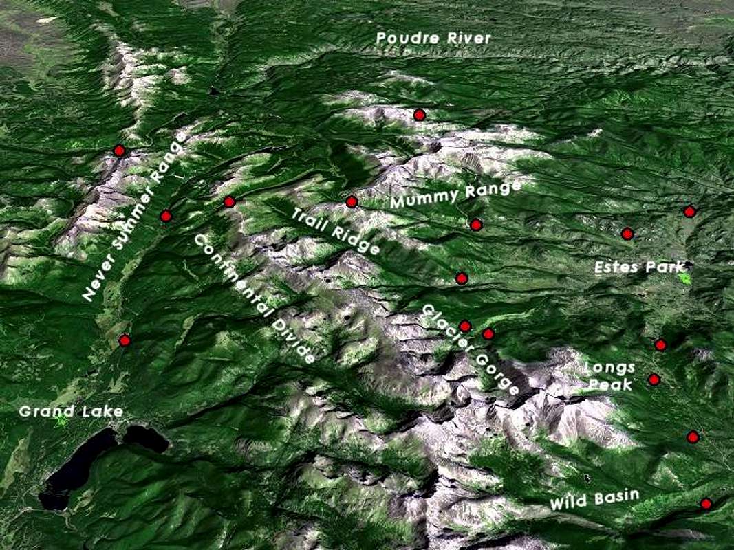
To see a large (2400 x 1800, 2 MB) image of this photo without any labels or red dots use this link.
Also, be sure to check out Kane's Mega Maps page for another perspective.
Panoramas
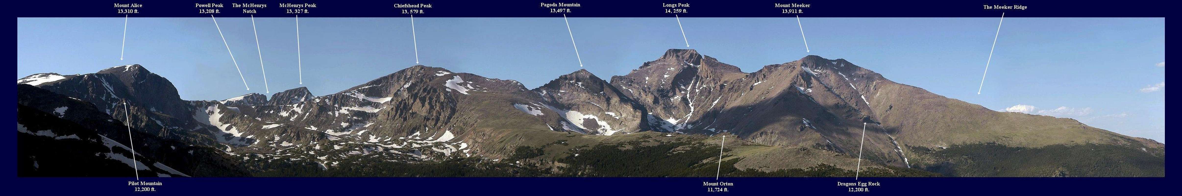
Longs Peak from Copeland Mountain
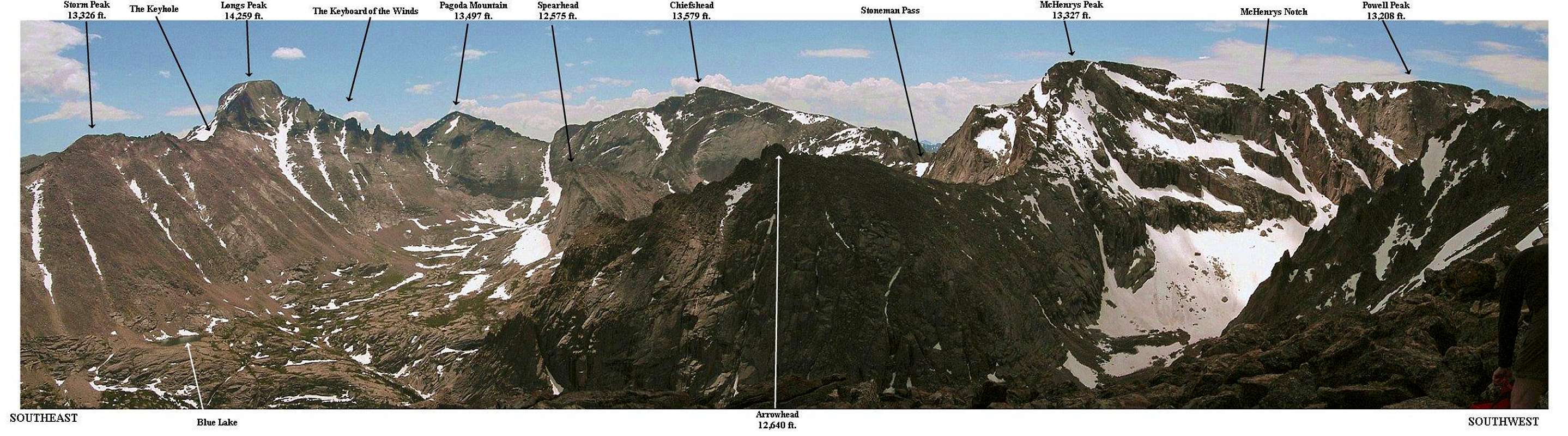
Thatchtop Summit Panorama
Mount Olympus Summit View

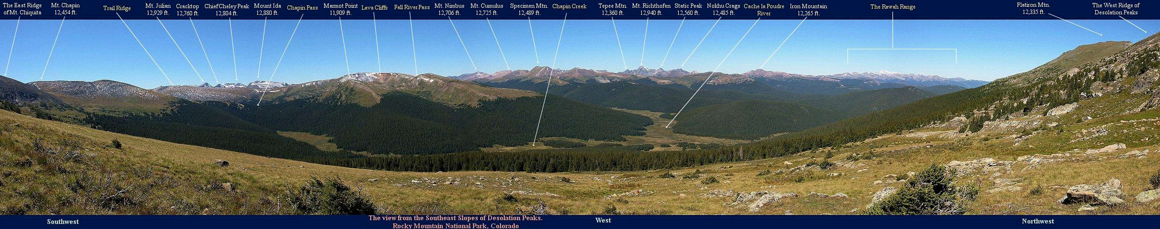
View From Desolation Peaks
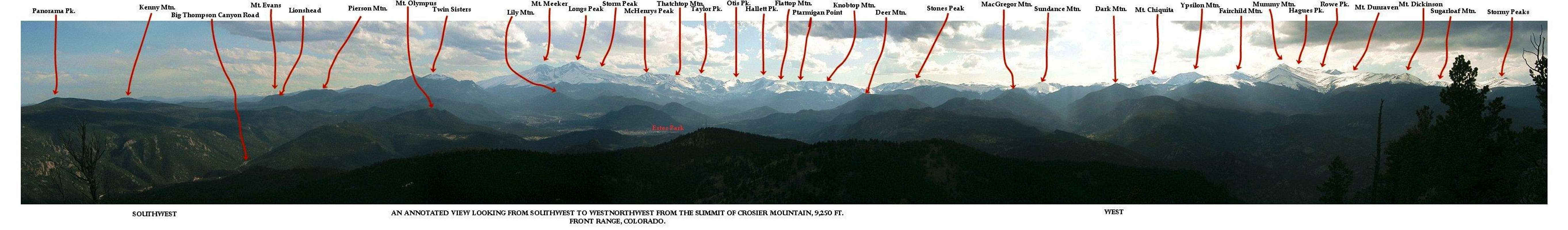
View From Crosier Mountain
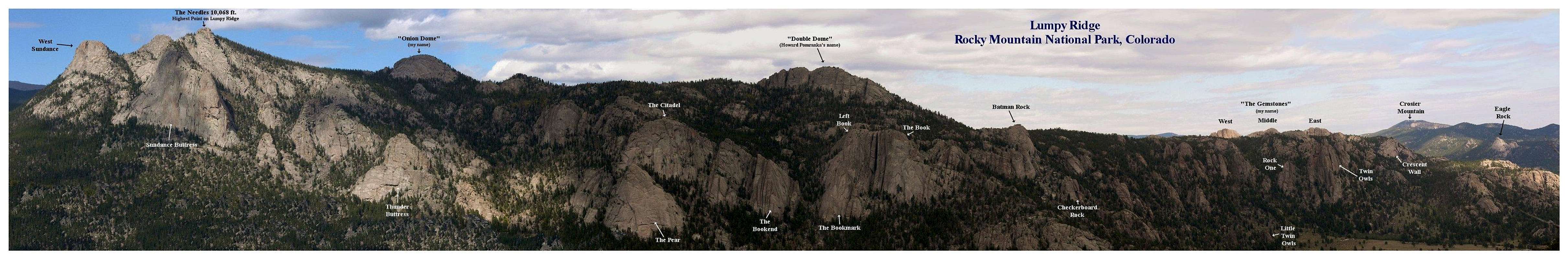
Lumpy Ridge
Trailheads and Peaks
These tables list the RMNP peaks that are on SP, and the nearest trailhead. The trailheads are sorted alphabetically, and the peaks are sorted by elevation within each trailhead's section.
Some of the peaks are just outside the Park, and many of the peaks can be reached via trailheads other than the one specified here. That is often spelled out on the peak's page, but if not, then finding alternative approaches is left as an exercise (no pun intended) for the reader.
The grades and class of the least difficult route are also specified. This implies that you stay on route. On all peaks there are numerous harder routes. Check the peak's page, or guidebooks, or do your own exploring. And, of course, there are assorted traverses and ridge walks such as the Longs Peak Grand Slam, Mummy Mania, or even the Glacier Gorge Traverse that will increase the grade by a notch or two!
Grades describe the overall length of the climb and are defined loosely as:
I - A short day and up to 3,000 feet of elevation gain
II - A full day and up to 5,000 feet of elevation gain
III - A very long day, more than 5,000 feet of elevation gain
Classes describe the technical difficulty of the climb where:
1 - On trail
2 - Off trail
3 - Scrambling, use of hands for balance required
4 - Difficult scrambling, basic rock climbing techniques may be necessary
5 - Technical rock climbing
Bear Lake

| Hallet Peak | 12713 ft / 3875 m | II, Class 2 |
| Hayden Spire | 12480 ft / 3804 m | III, Class 5.2 |
| Ptarmigan Point | 12363 ft / 3768 m | I, Class 2, Mod Snow |
| Knobtop Mountain | 12331 ft / 3758 m | II, Class 2 |
| Flattop Mountain | 12324 ft / 3756 m | I, Class 1 |
| Snowdrift Peak | 12274 ft / 3741 m | II, Class 2, Mod Snow |
| Notchtop Mountain | 12129 ft / 3697 m | I, Class 4 |
| Little Matterhorn | 11586 ft / 3531 m | I, Class 3/4 |
Chapin Pass

| Ypsilon Mountain | 13514 ft / 4119 m | I, Class 2 |
| Mount Chiquita | 13069 ft / 3983 m | I, Class 2 |
| Desolation Peaks | 12949 ft / 3947 m | II, Class 3 |
| Mount Chapin | 12454 ft / 3796 m | I, Class 2 |
Colorado River

| Howard Mountain | 12810 ft / 3904 m | II, Class 2 |
| Mount Cirrus | 12797 ft / 3901 m | II, Class 2 |
| Mount Cumulus | 12725 ft / 3879 m | II, Class 2 |
| Mount Nimbus | 12706 ft / 3873 m | II, Class 2 |
| Lead Mountain | 12537 ft / 3821 m | II, Class 2 |
| Lulu Mountain | 12228 ft / 3727 m | I, Class 2 |
Cow Creek

| Dark Mountain | 10859 ft / 3310 m | II, Class 2 |
Emmaline Lake

| Comanche Peak | 12702 ft / 3872 m | II, Class 2 |
| Fall Mountain | 12258 ft / 3736 m | II, Class 2 |
Fern Lake

| Stones Peak | 12922 ft / 3939 m | II, Class 2 |
Glacier Gorge

| Chiefs Head Peak | 13579 ft / 4139 m | II, Class 3 |
| Pagoda Mountain | 13497 ft / 4114 m | II, Class 3 |
| McHenrys Peak | 13327 ft / 4062 m | II, Class 3 |
| Powell Peak | 13208 ft / 4026 m | II, Class 2, Mod Snow |
| Taylor Peak | 13153 ft / 4009 m | II, Class 2, Easy Snow |
| Thatchtop | 12668 ft / 3861 m | II, Class 2 |
| Arrowhead | 12642 ft / 3853 m | II, Class 4 |
| The Sharkstooth | 12630 ft / 3850 m | II, Class 5.4 |
| The Spearhead | 12575 ft / 3833 m | II, Class 3 |
| Otis Peak | 12486 ft / 3806 m | II, Class 2, Easy Snow |
| Petit Grepon | 12000 ft / 3658 m | II, Class 5.8 |
| Half Mountain | 11482 ft / 3500 m | II, Class 2 |
Green Mountain

| Sprague Mountain | 12713 ft / 3875 m | II, Class 2 |
| Nakai Peak | 12216 ft / 3723 m | II, Class 2 |
Lake Agnes

| Mount Richthofen | 12940 ft / 3944 m | I, Class 2 |
| Static Peak | 12571 ft / 3832 m | I, Class 3 |
| Tepee Mountain | 12568 ft / 3831 m | II, Class 2 |
Lawn Lake

| Hagues Peak | 13560 ft / 4133 m | II, Class 2 |
| Fairchild Mountain | 13502 ft / 4115 m | II, Class 2 |
| Mummy Mountain | 13425 ft / 4092 m | II, Class 2 |
| Rowe Peak | 13404 ft / 4086 m | II, Class 2 |
Longs Peak

| Longs Peak | 14261 ft / 4347 m | II, Class 3 |
| Mount Meeker | 13911 ft / 4240 m | II, Class 3 |
| Storm Peak | 13326 ft / 4062 m | II, Class 2 |
| Mount Lady Washington | 13281 ft / 4048 m | II, Class 2 |
| Estes Cone | 11006 ft / 3355 m | I, Class 2 |
Lumpy Ridge

| Lumpy Ridge / The Needles | 10068 ft / 3069 m | I, Class 1 through 5.anything |
Meeker Park

| Lookout Mountain | 10715 ft / 3266 m | I, Class 4 |
| Horsetooth Peak | 10344 ft / 3153 m | I, Class 4/5.0 |
Milner Pass

| Mount Ida | 12880 ft / 3926 m | I, Class 2 |
| Chief Cheley Peak | 12804 ft / 3903 m | II, Class 2 |
| Mount Julian | 12928 ft / 3940 m | II, Class 2 |
| Cracktop | 12760 ft / 3889 m | II, Class 3 |
| Terra Tomah Mountain | 12718 ft / 3876 m | II, Class 3 |
Saint Vrain Mountain

| Saint Vrain Mountain | 12162 ft / 3707 m | II, Class 2 |
| Meadow Mountain | 11632 ft / 3545 m | II, Class 1 |
Stormy Peaks

| Stormy Peaks | 12148 ft / 3703 m | II, Class 2 |
Trail Ridge Road

| Sundance Mountain | 12466 ft / 3800 m | I, Class 1 |
Twin Sisters

| Twin Sisters Peaks | 11413 ft / 3479 m | I, Class 1 |
Wild Basin

| Mount Alice | 13310 ft / 4057 m | II, Class 2 |
| Copeland Mountain | 13176 ft / 4016 m | II, Class 2 |
| Ogalalla Peak | 13138 ft / 4004 m | II, Class 3 |
| Isolation Peak | 13118 ft / 3998 m | II, Class 2 |
| Elk Tooth | 12848 ft / 3916 m | II, Class 3 |
| Ouzel Peak | 12716 ft / 3876 m | II, Class 2 |
| Pilot Mountain & The Cleaver | 12411 ft / 3783 m | II, Class 3 |
| Hidden Falls Ice Climbing | N/A | WI2-4/ M4-6 |
Weather / Conditions
Typical for Colorado, conditions range from the calm, beautiful high pressure in summer, to howling white-out blizzards in the winter. Or, the other way around.
The biggest weather summer hazard is the afternoon thunderstorms which can build with alarming speed and danger. These are common from May through September are are often fully formed by noon. The Front Range is also known for ferocious wind, especially in winter.
First off, be sure to check out SP member sshankle's page on Colorado Front Range Weather
Colorado Mountain School guide Eli Helmuth has a great web page with current park climbing conditions: ClimbingLife.com
National Weather Service Longs Peak Ranger Station forecast, elevation 9420 feet. Of course specific mountain conditions vary wildly over small distances.
Forecast for Trail Ridge Road, 11,700' elevation
Estes Park forecast, the gateway town on the east side of RMNP.
Weather charts data from the Niwot Ridge Meteorological site, located at at 11,572 ft (3528 m) on Niwot Ridge, 30 miles south of RMNP. This gives you an indication of recent regional high altitude conditions.
Colorado Avalanche Information Center, more mountain forecasts and current conditions, highly useful avalanche information. Operates in winter months only. Be certain that I am not accompanying you if you are venturing into avalanche terrain. It could ruin your day.
Resources and Links
The official RMNP site:
Official Rocky Mountain National Park Website
Park Map Viewer
List of Hiking Trails
Bear Lake Corridor Trail Map
RMNP Climbing and Mountaineering Page
RMNP Backcountry Camping Page
Backcountry Camping Sites
Bivouac Sites List
A good external site with listed hikes and other information.
The Colorado Mountain School site has details about their courses and guided climbs in the Park, and elsewhere.
Some Estes Park and Grand Lake web sites for accomodation, dining, etc.
www.estes-park.com
Estes Park Visitors Bureau
estes.on-line.com
Grand Lake Chamber of Commerce
The Rocky Mountain Nature Association offers fields trips, seminars, and has a good selection of books.
Some good books (links take you to Amazon.com):
Lisa Foster, Rocky Mountain National Park: The Complete Hiking Guide. The best RMNP hiking guide. Buy it if you want great information about both standard and obscure Park hikes.
Rocky Mountain National Park: Classic Hikes and Climbs . It's out of print but this is my favorite peak bagging book . Roach is intentionally somewhat vague about the routes. Figuring them out is a great part of the fun. See if you can find a copy if you are into hitting peaks via basic mountaineering routes.
Bernard Gillet, Rocky Mountain National Park: Estes Park Valley: The Climber's Guide
Bernard Gillet, Rocky Mountain National Park: High Peaks: The Climber's Guide
Dougald Macdonald, Longs Peak: The Story Of Colorado's Favorite Fourteener
Paul Nesbit, Longs Peak: Its Story and a Climbing Guide
Richard Rossiter, Rock Climbing Rocky Mountain National Park: The Crag Areas
Richard Rossiter, Rock and Ice Climbing Rocky Mountain National Park: The High Peaks
A fun map, not to take on the trail but to hang on your wall and plan your next trip:
Trail Tracks Rocky Mountain National Park Hiking Map
Finally, the NPS has posted the entire text of Roger Toll's 1919 classic Mountaineering in the Rocky Mountain National Park. Thanks to brenta for bringing this to my attention. It is worth having a look. Click on the cover image below:
The table of contents has links to the old photos in the book:
Parting Shot
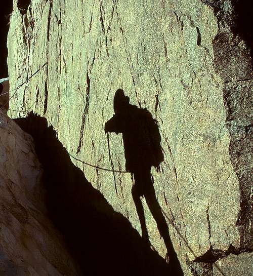 Lamb's Slide, Kieners Route, Longs Peak