
|
|
Area/Range |
|---|---|
|
|
45.26800°N / 117.262°W |
|
|
Hiking |
|
|
Overview
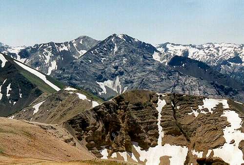
Looking south from the summit of Chief Joseph Mountain to the north face of Sacajawea Peak.
Introduction
The spectacular Wallowa Mountains of northeastern Oregon are situated in a southeast to northwest orientation and cover an area roughly 35 by 60 miles, with most being taken up by the Eagle Cap Wilderness. There are at least 31 peaks that rise above 9,000 feet that make up the largest subalpine/alpine area in Oregon. The major drainages radiate in all directions from the Eagle Cap near the center of the range. This high peak was once erroneously thought to be the highest in the Wallowas because of this. The elevations range from about 3,000 feet to almost 10,000 feet with the highest mountains being in the north-central area. Much of the range rises more than a mile above the surrounding valleys. Sacajawea (9,838 ft.) and Matterhorn (9,826 ft.) are the sixth and seventh highest summits in Oregon; however it may not be clear which is truly the highest. Until recently most maps listed Matterhorn as the highest at 9,845 feet. Some older sources listed the Matterhorn at 10,004 feet, while others also had Sacajawea just over 10,000 feet. Stay tuned for future changes.
While some technical rocks can be found on many of the mountains, almost all have walkup or scramble routes. Some of the areas of notable technical climbing are the summit tower of Twin Peaks, and the huge west wall of the Matterhorn. Often, the rock types are very crumbly and not desirable for traditional climbing. However, for hiking in a rugged landscape and sheer number of spectacular mountains the Wallowas are one of the best mountain ranges to be found anywhere.
 |
 |
 |
 |
 |
 |
 |
Eagle Cap Wilderness
In 1930, the Eagle Cap was established as a primitive area. It was designated as wilderness in 1940. The Wilderness Act of 1964 placed the area in the National Wilderness Preservation System. It was enlarged by 73,410 acres in 1972, and by 67,711 acres in 1984 and now totals 361,446 acres of designated wilderness. Today, the Eagle Cap Wilderness is the largest wilderness in Oregon.
The Eagle Cap Wilderness is characterized by high alpine lakes and meadows, bare granite peaks and ridges, and U-shaped glaciated valleys. Plant communities range from low elevation grasslands and ponderosa pine forest to subalpine meadows and alpine. Engelman spruce, western larch, mountain hemlock, sub-alpine fir, and whitebark pine can be found in the higher elevations. Elevations range from 5,000 feet in lower valleys to near 10,000 feet on the highest of the majestic peaks.
The Eagle Cap Wilderness is the most heavily used wilderness in northeast Oregon, with the Lakes Basin Management Area the most popular. This area and others accessed by the trailheads at Wallowa Lake, Hurricane Creek and Lostine River can be very crowded on holidays and weekends, yet solitude can be found with over 534 miles of to choose from. It also helps to plan your trip for the spring or fall or on weekdays.
 |
 |
 |
 |
 |
 |
 |
Peak List
Following is a list of most of the significant peaks in the Wallowa Mountains. Generally these mountains are either named or have prominence exceeding 300 feet. It includes most peaks that fulfill these criteria, but is not complete. Links SP are provided for those having completed SP pages. (huge thanks to brendon and gangolf for html help)
 Sacajawea Sacajawea Hurwal Divide Hurwal Divide Petes Pt Petes Pt Hurricane north Hurricane north Eagle Cap Eagle Cap Cusick Mt Cusick Mt Glacier Pk Glacier Pk Sentinel Pk Sentinel Pk Hurricane south Hurricane south North Imnaha North Imnaha Dollar Ridge Dollar Ridge Krag Pk Krag Pk Needle Pt Needle Pt Marble Mt Marble Mt |
|
 Matterhorn Matterhorn Aneroid Mt Aneroid Mt Twin Pks Twin Pks Chief Joseph Chief Joseph Red Mt Red Mt Hurwal south Hurwal south Hidden Pk Hidden Pk Polaris Pt Polaris Pt East Pk East Pk Pk 9,180 Pk 9,180 Bonneville Mt Bonneville Mt Sawtooth Pk Sawtooth Pk McCully/Little Sheep divide McCully/Little Sheep divide Ruby Pk Ruby Pk |
Wild and Scenic Rivers
The alpine and subalpine terrain provides the start of several major watersheds draining from these mountains. The Imnaha drains the eastern side of the mountains and flows north through one of the largest canyons in the U.S. to meet with the even larger Hells Canyon. The Lostine, Minam and Wallowa Rivers drain the north slope into the Grande Ronde many miles north of the mountains. The west side drains into the Grande Ronde River, which flows north eventually to the Snake near the mouth of Hells Canyon. And the south drains into Eagle Creek, Pine Creek and some tributaries to the Powder River.
The Lostine, Minam and Imnaha Rivers and Eagle Creek are designated Wild and Scenic Rivers for their outstanding characteristics. The Wallowa River is also designated, but from its meeting with the Minam River at the base of the Wallowas downstream to the confluence with the Grande Ronde, which is also a Wild and Scenic River north of the mountains.
Access
Polaris Point/Pass
Tenderfoot Pass
The Wallowas are accessed in the north roads from the towns of Wallowa, Enterprise, Joseph and Lostine; from the west the towns of LaGrande, Elgin, Union and Cove; and from the south via Baker City, Halfway and Richland. There are no towns or highways on the east side of the mountains, but a scenic drive (Forest Service road 39) skirting the edge of Hells Canyon and providing routes to the eastern trailheads runs between the Oxbow vicinity on the Snake River north to the town of Joseph. A unique way to experience the Wallowas is to take the Wallowa Lake Tram to the top of Mount Howard. The tram starts just south of Wallowa Lake and claims to be the steepest tram in the world. At the summit of Mount Howard (8,241 ft.) there are easy trails and stupendous views of the Wallowa River Canyon and the highest peaks in the range as well as views of the forested flats to the north and east across Hells Canyon to the Seven Devils Mountains and beyond in Idaho.
The following trailhead information is broken down by general areas of the Wallowas. A short account of where the trailhead is located and some of the areas reached by the trailhead are provided. The trailheads and areas accessed are provided for general presentation information only. Consult maps, guidebooks, local Forest Service offices or specific SP mountain pages for adequate information on reaching your trailhead and ultimate destination. Not all the trailheads accessing the Wallowa Mountains are listed here. In addition a list of trails and trailheads provided on the Wallowa-Whitman website provides ample information needed to access these mountains.
North Central Area
McCully Trailhead – Access via Tucker Down Road east of Joseph.
McCully Basin, Wing Ridge, Aneroid Mountain
Wallowa Lake Trailhead – End of the road south of Wallowa Lake
East Fork Wallowa River, Aneroid Lake, Aneroid Mountain, Petes Point, Tenderfoot Pass, headwaters of Imnaha Basin, West Fork Wallowa River, Matterhorn, Ice Lake, Lakes Basin, Hawkins Pass
Hurricane Creek Trailhead – Road 8205, Hurricane Creek Road, south from Enterprise
Hurricane Creek, Hurricane Divide, Twin Peaks, Sacajawea, Lakes Basin
Two Pan Trailhead – Road 8210, south of Lostine
East Fork Lostine River, Lakes Basin, Eagle Cap, Glacier Peak, Horton Pass, West Frok Lostine River, Minam Lake, upper Minam River, Swamp Lake, Steamboat Lake
Maxwell Lake Trailhead – Road 8210, south of Lostine
Maxwell Lake
Frances Lake Trailhead (Lillyville) – Road 8210, south of Lostine
Frances Lake, Hurwal Divide, Twin Peaks
Bowman Trailhead - Road 8210, south of Lostine
Brownie Basin, Wilson Pass, Chimney Lake, Hobo Lake, North Minam Meadows, Lookout Mountain, Laverty Lakes
Western Region
Bear Creek Trailhead – Road 40, off of road 8250, south from Wallowa
Bear Creek, Bear Creek Cabin, Goat Creek, Huckleberry Mountain
Bear Wallow Trailhead – Road 50 off road 8270, south from Minam
Deer Creek, Bear Creek, Standley Cabin, Washboard Ridge, Minam River
Middle Cougar Ridge Trailhead – Road 8270, south from Minam
Cougar Ridge, Standley Cabin
Moss Spring Trailhead – Road 6220, east of Cove
Minam River, Little Minam River, Reds Horse Ranch, Minam Lodge, Millard Cabin, Catherine Creek Cabin
Southern Region
North Fork Catherine Creek Trailhead – Road 7785, east of Union
Catherine Creek Basin, High Hat Butte, Squaw Butte
Buck Creek Trailhead – Road 7785, then 7787, east of Union
Burger Butte, China Cap, Granite Butte, Diamond Lake, Tombstone Lake, Minam River
West Eagle Trailhead – North of road 77
West Eagle Creek Basin, Tombstone Lake, Echo Lake, Traverse Lake, Wonker Pass, upper Minam River
Main Eagle Trailhead – Road 7755 north from road 77
Boulder Park, Lookingglass Lake, Copper Creek Falls, Needle Point, Eagle Lake, Culver Lake, Bear Lake, Heart Lake, upper Minam River
East Eagle Trailhead – Road 7745 north from road 77
Eagle Creek, Crater Lake, Krag Peak, Red Mountain, South Fork Imnaha headwaters, Hidden Lake, Horton Pass, Frazier Pass, upper Minam River, Pine Lakes
Summit Point Trailhead – Road 7715 north of road 77
Schneider Cabin, Pine Lakes, Red Mountain, Crater Lake, Cornucopia Peak
Cornucopia Trailhead – Road 4190, Cornucopia Road, at north end of Cornucopia town
Cornucopia Peak, Schneider Cabin, Pine Lakes, South Fork Imnaha River, Marble Mountain
Eastern Region
Deadman Canyon Trailhead – End of road 410, just north of Fish Lake
Sugarloaf Mountain, Imnaha Falls, South/Middle Fork Imnaha Rivers
Twin Lakes Trailhead – Twin Lakes Campground on road 66
Imnaha River, Blue Hole
Indian Crossing Trailhead – End of road 3960, off road 39
Imnaha River, Blue Hole, Imnaha Falls
Lick Creek Trailhead – Road 15
Imnaha Divide, South/Middle Fork Imnaha Rivers
Tenderfoot Trailhead – Road 100, four miles west of road 39
Sheep Basin, Bonny Lakes, Mt. Nebo, North Fork Imnaha Basin, Tenderfoot Pass, Aneroid Mountain, Wing Ridge
Salt Creek Summit SnoPark – Road 39, east and south of Joseph
Wing Ridge, Sheep Basin
Geology
Overview
 Its all here on Chief Joseph: basalt cap over brown hurwal rocks, light limestone and greenstone below.
Granodiorite with basalt dikes, Eagle Cap

Hurwall shale, Martin Bridge limestone with marble band, North Imnaha
Basalt over baked Hurwal rock, Twin Pks

Hurwal, limestone, basalt dikes, Cusick, Pk 9,180
In the mid-1990s a note was left in the summit register on Aneroid Peak by a man who described himself as a geologist from an eastern university. The note contained the standard details of the scramble up the mountain and his plans for the rest of the trip. Also included was an enthusiastic statement proclaiming the Wallowas to have the “greatest geology on earth”! Whether this is a true statement or an exaggeration, to someone standing atop Aneroid and looking at the dark, angular rocks of the moon-like ridges running to the north and east, the bizarre wavy patterns of color on Petes Point and the bright rock of Eagle Cap and the Matterhorn to the west, it would seem obvious, even to someone who knows nothing about the geology of the area that something special was going on here.
The story begins with a series of volcanic islands in the ancient Pacific Ocean that erupted around in the Permian period about 250 to 270 million years ago. Sediments collected around the islands formed sandstone and limestone, while lava formed the slopes. The Wallowa Terrane as this island arc became known eventually ran into the west coast of what was then North America. The collision altered and deformed the material, forming metamorphic rocks. The process of two plates pressing together and fusing is called accretion, which in this case took about 40 million years to complete. The rocks of the Wallowa Terrane are relatively young at 190 to 270 million years old as compared to the 2 to 3.5 billion year old rocks of the North American land mass.
Next a period of uplift occurred during the last 65 million years of the Cenozoic Era. The Wallowa batholith crystallized about 15 miles below the surface during this time. The heat from the batholith caused some metamorphosis of the rock it came in contact with. By the Miocene Epoch (5 to 25 million years ago) much of the surface rocks had eroded away and the batholith surface was exposed in many areas. Approximately 17 million years ago tremendous eruptions of flood basalts poured out of the earth and covered much of the inland northwest, including what would become northwest Oregon.
Over the next few million years erosion lowered the mountains and took away much of the basalt surface. Then during the last few million years there was significant uplift of the region that formed an escarpment along the Wallowa fault. The land south of the fault rose while the land to the north dropped to create the spectacular abrupt northern mountain front seen today. Similar movements along faults on the south side of the mountains also occurred but the uplift was not quite as great. This movement is why basalt exists today on some of the highest of the Wallowa Mountains as well as the general landscape in the valleys below.
These processes have laid down five major rock types that make up the mountains today. These are the Clover Creek Greenstones, Martin Bridge Formation and the Hurwal Formation of the original Wallowa Terrane; the granodiorite of the Wallowa Batholith and the Columbia River Basalts; all of which were later acted upon by glaciation during the Pleistocene and Holocene. Following is a brief account of each rock type and where they can be seen in the complex mix of the Wallowa Mountains.
Wallowa Terrane
Clover Creek Greenstones
These are the oldest rocks in the Wallowa Mountains, formed during the Permian and Triassic (225 to 270 million years ago). They are of volcanic and volcanic sedimentary rocks that were metamorphosed into greenstone. The rocks contain minerals that give them their greenish color. These rocks form much of the north face of Chief Joseph Mountain and the forks of the Imnaha River in the eastern region. In the southern mountains look for them in the Krag Peak and Red Mountain areas.
 |
|
Martin Bridge Formation
The Martin Bridge Formation is mostly sedimentary limestone that was formed in warm, tropical waters around the volcanic chain of the Wallowa Terrane during the Triassic. In some areas it has been metamorphosed to form marble. In the southern parts of the range, this limestone is dark due to the presence of carbon, but most in the central mountains is light colored largely due to the presence of the marble form. This formation contains abundant fossils. The Martin Bridge Formation can be seen as the spectacular summits of Matterhorn and Sacajawea in the central mountains. There are also exposures in the Imnaha/Wallowa Divide and the East Fork of Eagle Creek.
 |
|
 |
 |
 |
 |
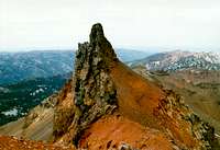
Hurwal Formation
The Hurwal Formation generally lies above the Martin Bridge Formation and is late Triassic to early Jurassic in age. These rocks were formed as sediments from the volcanic islands that were deposited in the ocean to form gray to brownish red shale. Some metamorphosis of the rock has occurred. The iron oxide mineral pyrite has been oxidized to form a rusty red in some areas. This red effect is especially visible at the summit of Twin Peaks. Other places the Hurwal Formation can be seen are along the Hurricane Divide, Sentinel Peak, Pete’s Point and the Hurwal Divide for which it was named.
 |
 |
 |
 |
 |
 |
Wallowa Batholith
This feature is made up of granodiorite, which is intermediate in mineral composition between granite and diorite. The batholith formed about 140 to 160 million years ago when magma formed deep inside the earth and crystallized before reaching the surface. While still hot the batholith came in contact with the rocks of the Wallowa Terrane causing them to metamorphose. As the intruding rock cools, residual fluids with elements such as gold, silver and copper are the last to crystallize into rock. These fluids shoot into the cracks in the surrounding rocks to form dikes that become mineral lodes. Erosion and uplift later eventually exposed this granodiorite body. The bright granodiorite rock can mainly bee seen in the central and southwest Wallowas. They are the dominate rock of the southern Wallowas and the popular Lakes Basin area.
 |
 |
 |
Columbia River Basalts
The flood basalts erupted about 17 million years ago from long fissures in the earth and covered hundreds of square miles of the inland northwest and even reached the Pacific Ocean. There were several eruptive cycles, but most of the material was deposited during a short time referred to as the Grande Ronde period. This flowing lava cut through cracks in the much older rocks of the Wallowa Terrane and Wallowa Batholith and today can be seen as the sometime spectacular dark brown dikes streaking through the lighter rocks. The cause of these huge eruptions is not known. Some geologists feel they were the result of subduction that took place on the coast during the Miocene times. Others believe the Yellowstone hotspot passed under the area long before it traveled across the Snake River Plain into Wyoming. Another theory promotes the idea that a huge asteroid hit south eastern Oregon causing the fractures that allowed the flows to erupt from the earth.
The layers of basalt on either side of the fault can be matched up to determine the extent of the uplift of the range. Basalt on the tops of some of the higher peaks match up with layers in the Imnaha Canyon that indicate the uplift was over 7,000 feet. The dark layers, caused by successive lava flows, can be seen throughout the large canyons north and east of the mountains. In the mountains themselves look for the flow basalts on the tops of peaks such as Chief Joe Mountain, Aneroid Peak, East/Hidden Peaks, Brown Mountain, China Cap, Ruby Peak and several of the ridges in the western region. The often spectacular dikes can be seen on Eagle Cap, Cusick Mountain and the upper east slope of North Imnaha.
 |
 |
 |
 |
 |
 |
Glaciation
The final significant geologic processes were periods of Pleistocene glaciation that occurred about 15,000 to 22,000 years ago and left the Wallowas with the stark, dramatic landscape we are familiar with today. The glacially formed arêtes, horns, lake-filled cirques, U-shaped valleys, cols, hanging valleys and moraines are amply represented on the modern Wallowa landscape. Much more recent episodes of local alpine glaciation have also contributed, but today only some perennial ice packs remain.
During the height of glaciation a large ice cap covered much of the higher Wallowa Mountains, especially the large neve field where the Lakes Basin now occurs. This body fed tongue glaciers that descended all the major valleys, some extending more than 20 miles onto the flat country beyond the mountains. The glacier that filled the Lostine River Canyon was the longest, but the one extending from the Wallowa River Canyon was probably contained the most ice and was at least 2,000 feet thick. The massive moraine deposits at the mouth of the canyon can be seen today as the hills that have formed Wallowa Lake. The primary glaciers filled the Wallowa, Hurricane, Lostine, Minam, Imnaha, Pine and Eagle canyons. The Pine Glacier descended as low as 3,000 feet.
The major glacial period ended about 15,000 years ago, but there have been at least three periods of neoglaciation recognized in the Wallowas; about 8,000 years ago, 2,000 years ago and from 1350-1850 AD (the Little Ice Age). The last active glacier in the Wallowa Mountains was Benson Glacier on the slopes of Glacier Peak above Glacier Lake. Benson Glacier ceased to be active in the 1930s and since has been one of the largest ice caps in the Wallowas. Other modern glacial remnants can be seen on Eagle Cap, Hurricane Divide, and many other places.
 |
 |
 |
 |
|
 |
History
The first permanent inhabitants of the Wallow Mountains and surrounding valleys were the Nez Perce, Cayuse, Shoshone and Bannock Indian tribes. They used the mountains primarily in summer to hunt bighorn sheep and deer and to gather berries. During the winter they generally descended to the low elevation, warm, river canyons of the Snake River and its tributaries.
In 1811 the first non-Indians to see the Wallowa Mountains are members of the Hunt expedition as they traveled through the Powder and Grande Ronde River valleys. Trappers soon followed. The first non-Indian to see the Wallowa Valley and Wallowa Lake on the north side of the mountains was probably the Reverend Henry H. Spalding, a Protestant missionary to the Nez Perce. Beginning in 1845 thousands of emigrants traveled the Oregon Trail that passed by the southern side of the mountains on their way to the Willamette Valley. The first Nez Perce Indian Reservation was soon after established in the Wallowa Valley. Eventually white settlers began to move into the area and the U.S. Government established a new reservation that was much smaller and less desirable than the first. This was not well received by the natives who refused to leave the valley as more settlers poured in. This eventually led to the Nez Perce War in 1877 and the displacement of the Indians from this portion of their homeland.
The first road reached the Wallowa Valley in 1879 and gold was discovered in the southern mountains near Cornucopia in 1882. These mines formed one of the largest gold mining operations in the U.S. with an estimated 36 miles of tunnels reaching a depth of 3,000 feet. These mines produced more than 15 million dollars of gold in the 1930s and 40s. Silver and copper were also important minerals and there was some utilization of limestone and marble as well. The legacy of mining in this area can still be seen today with the decrepit building, shafts and mine tailings. With the coming of the railroad, logging and other land management such as ranching and farming the region was rapidly developed.
Climate


Several local climatic zones are represented in northeast Oregon resulting from the extremes in elevation, geographic variation, and topographic diversity throughout the area. Deep canyons in close proximity to high mountains often create climatic variations over short distances. However the major influence to the regional climate comes from the Cascade Mountains lying nearly 200 miles to the west. This mountain range forms a barrier against modifying effects of moist winds from the Pacific Ocean and, as a result, the climate of the area is essentially dry. In general the climate for much of the area is categorized as temperate continental. Light precipitation, low relative humidity, rapid evaporation, abundant sunshine, and wide ranges in temperature are characteristic for this climate type. But there are marked local differences in temperature and precipitation owing to local topography.
The Columbia River Gorge breaks the barrier of the Cascade Mountains to allow maritime air laden with clouds and moisture to influence the northern Wallowa Mountains. This is called a temperate oceanic climatic regime. It contrasts greatly with the temperate continental climate that strongly influences the southern part of the range. The oceanic climatic influence provides a greater number of cloud days with higher humidity, increased precipitation and less fluctuation in winter temperatures. The continental influence with less cloudiness, less humidity, and lower precipitation levels promotes drier forests, sagebrush and juniper. The oceanic climate promotes moist forests, grasslands and rhizomatous shrubs.
The Wallowa Mountains trap the southerly storm tracks resulting in 65 to 70 inches of precipitation per year. The heaviest precipitation is generally in winter with a secondary period of high precipitation occurring in May and June when spring rains or wet snows fall in the mountains. More precipitation falls on the west side of the mountains as the air rises, leaving less for the east part of the range. Thus the west-central and higher central parts of the mountains hold all of the significant persistent snow packs. The area is often under the influence of a continental anticyclone that results in high pressure air masses that produce clear skies, lack of cloud cover, and extremely cold temperature. Summer temperatures are often in the 70s and 80s, while night time lows are generally in the 40s, though it can dip below freezing any time of the year.
Flora
Vegetative Zones


The colder temperatures and lower precipitation levels of the southern Wallowa Mountains provide vegetation with a Great Basin-Central Rocky Mountain flora (i.e. sagebrush/grass), whereas the higher precipitation levels and less severe temperatures of the northern Wallowa Mountains provides a Palouse-Northern Rocky Mountain flora (i.e., rhizomatous shrub/grass). Because the western portion of the range receives more rainfall, the vegetation there is denser and wetter species are represented. Mountain hemlock, a common forest species of the Cascade Mountains is represented on the higher west and central forested slopes of the Wallowa Mountains. Despite this overall moisture difference between the north and south parts of the range, the vegetation zones of the range follow a general pattern, but with the north supporting denser forests and moister species.

The lower timberline is determined by lack of moisture, which is influenced by topography and local climate. The lower elevations of the range are generally dominated by grasslands that merge into mahogany shrub fields and open stands of Ponderosa pine. As elevation and moisture increase, the forest becomes more mixed with Douglas fir, and grand fir. More exposed slopes with thin, drained soils may still be dominated by grass or shrublands. With increases in elevation the forests continue to tend to cooler moister communities and species such as lodgepole pine, grand fir and mountain hemlock may become dominate. In the bottoms where cool air accumulates subalpine fir and spruce can be locally abundant. Fire plays an active role in the development of these forests. Huge areas of low to mid-elevation forests have been destroyed and renewed by fire primarily on the eastern slopes of the Wallowas.

Still higher, lush subalpine forests become widespread with spruce, subalpine fir and whitebark pine making up most of the forest community, but other species exists at appropriate microsites. The vegetation thins out creating a beautiful parkland setting. Mountain lakes and associated meadows are well represented. These areas are generally deeply eroded by glaciation and the action of various rivers and creeks. Snows lie well into the summer giving abundant water, but the growing season is very short. Wetlands and shrub swamps occur here providing important habitat for wildlife.

Higher yet, the open timberline communities are found. Upper timberline is controlled by cold temperature, high winds and deep persistent snows. Also these rocky slopes are steep and unstable and the often sandy or gritty soils are well drained. This creates open dry conditions that support only very open forest of whitebark pine and subalpine fir that exhibit the effects of the extremes of high mountain weather. The Wallows also have a few stands of limber pine, which along with the Strawberry Mountains are the only sites in Oregon. These high elevation trees tend to collect in small groups and become dwarfed, twisted and one-sided due to harsh winds. The ground vegetation is sparse, tends to be hairy, to have shortened stems or to sprawl over the ground to take advantage of any depression, crack, crevice or other shelter. Often these plants form dense, rubber-like mounds to withstand the harsh climate. These communities generally start at about 8,000 feet throughout the range, but occur as low as 7,100 feet near Frazier Lake and rise to about 9,000 feet in other places. Above these elevations, tree growth is precluded by the prevalence of rock substrate or extremes in climatic conditions.
Floral Geography

Floristically these mountains are special because they are at a geographical cross road for much of the western United States. As past climates fluctuated, species slowly migrated north and south keeping in the appropriate moisture and temperature regimes required. High mountain ranges such as these provide elevational gradients that allow species to similarly ascend or descend over time with their preferred local climate. Thus a species may generally retreat far to the north, but isolated islands of suitable habitat may linger at an appropriate elevation enabling the species to exist as an outlier of the general range. In this manner several far flung plant species are represented here that have general ranges in such places as the Sierra Mountains, coastal-Cascades, main Rocky Mountains, Great Basin and northern boreal regions.
Unique Elements

Another special botanical characteristic of the Wallowa Mountains is the high number of endemic species. Many of these are limited to northeast Oregon, but others have a global distribution that includes only these mountains. The origin of this high endemism may related to the isolated geographic history, but likely also is the result of isolation that has enabled some of the species separated from its primary range to evolve into new species over time. There are approximately three dozen species that are disjunct from the Cascade or Sierra Mountains to the west and two dozen regional endemics that are limited to northeast Oregon or immediately adjacent areas. There are eight that are found only in the Wallowas Mountains. Of particular note are the Indian paintbrushes (Castilleja ssp.) of which there are two regional endemics and five global endemics.
Fauna
Wildlife

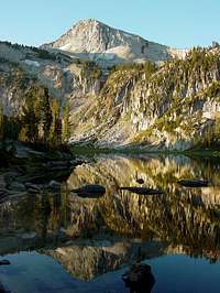
Mirror Lake
The diverse habitats also support a variety of wildlife species. Mule deer, whitetail deer and black bear are common. Bighorn sheep were extirpated in the 1940s, but reintroduced in 1971. After extensive disease related mortality in the 1980s they have rebounded to healthy population today. The largest bighorn ever taken in the U.S. was from the Wallowa Mountains. Mountain goats have adapted well to the high rocky peaks and ridges in much of the range and can actually contribute to the local destruction of sensitive subalpine habitats through trampling. The goats were introduced in the 1950s and it is not certain whether this species was native to the region. The forest and grassland mosaics common at mid and lower slopes are frequented by elk. Historically pronghorn antelope roamed the open country on the southern slopes of the Wallow Mountains. In recent years they have been showing up here again despite the efforts of game officials to capture and relocate them for eating alfalfa fields.
The most common predators are mountain lions, coyotes and bobcats. However rare wolverines and lynx are probably also present. In 1994 the State of Oregon outlawed the use of dogs in the hunting of mountain lions. Consequently the population of these big cats has increased dramatically, which has caused a decline in the deer and elk numbers. In recent years occasional wolves have dispersed from the expanding populations in central Idaho and turned up in eastern Oregon. These have either been killed by cars or trapped and returned to Idaho. It is likely that others wanderers remain undetected in the Wallowa Mountains, but as of yet no pack activity has been noted. The lynx is listed under the Endangered Species Act (ESA) as are the bald eagle, golden eagle and peregrine falcon.
Fish
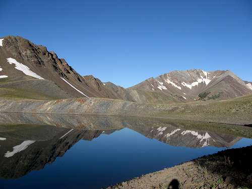 Dollar Ridge and Petes Pt reflected in Dollar Lake. Photo by Mr. Clam
Most of the lakes in the Wallowa Mountains did not support fish historically, but rainbow trout, brook trout and cutthroat have been stocked. A very few lakes also have introduced California golden trout. Many of the streams have native redband and cutthroat trout and some of the larger streams and rivers such as the Lostine, Imnaha, Wallowa and Minam Rivers host seasonal runs of anadromous summer steelhead and Chinook salmon. which are listed under the Endangered Species Act. Wallowa Lake is stocked with lake trout and kokanee salmon and supports native whitefish and bull trout. The salmon, steelhead and bull trout are listed under the ESA.
Lakes
Mirror Lake
Depending on how they are counted there are approximately 104 mountain lakes in the range. There is no clear division between what a lake is and what is a pond, but the list is fairly inclusive, though some ponds were definitely left out. Due to their scenic beauty and prime camping locations, the lakes of the Wallowas are popular destinations for recreationists who come to the mountains in increasing numbers every year. Some of the higher lakes may be partially ice covered until the end of July. A few are very remote and are rarely visited, but some of the more popular bodies in the Lakes Basin can be overrun with crowds on holidays and nice weekends. Refer to the Red Tape section for special regulations involving some of these lakes.
Most of these lakes are in glacial cirques or tarns. Some others were formed by landslides that left streams natually damed. Legore Lake near Twin Peaks is the highest true lake in Oregon to support a fish population. Few if any of the high lakes supported fish populations historically, but today have been planted with rainbow trout, cutthroat trout, brook trout and at least two have golden trout. Many lakes, especially on the southern side have had their outlets regulated with damn-like structures to regulate the flows during the summer of irrigation purposes for the agricultural Baker Valley below. Full reservoirs, which there are many of just outside the wilderness on the south flank of the range were excluded from the list.
In the following table the lakes are arranged alphabetically with unnamed lakes refered to as "Lake" followed by a brief location description. Elevations for each body of water is given, but some of these are approximate.
| Lake | Elev. | Lake | Elev. | Lake | Elev. | Lake | Elev. |
| Aneroid Lake | 7,500 | Frances Lake | 7,505 | Lake (west or Ice Lk) | 8,140 | Moccasin Lake | 7,475 |
| Arrow Lake | 7,800 | Frazier Lake | 7,127 | Lake (Last Chance Ck) | 7,940 | Moon Lake | 7,060 |
| Bear Lake (Bear Ck) | 7,905 | Glacier Lake | 8,166 | Lake (Lostine Canyon) | 3,676 | Olive Lake | 7,460 |
| Bear Lake (Eagle Ck) | 7,180 | Green Lake | 6,699 | Lake (Matterhorn) | 9,140 | Pine Lakes (2) | 7,540 |
| Billy Jones Lake | 8,240 | Hazel Lake | 7,420 | Lake (Millard Cabin) | 3,685 | Pocket Lake | 8,225 |
| Blue Lake | 7,703 | Heart Lake | 7,340 | Lake (ne of Minam Lk) | 8,305 | Pop Lake | 7,546 |
| Bonny Lakes (2) | 7,800 | Hidden Lake | 7,173 | Lake (lower Moccasin Lk) | 7,476 | Prospect Lake | 8,328 |
| Cached Lake | 7,340 | Hobo Lake | 8,369 | Lake (sw of Moccasin Lk) | 7,376 | Razz Lake | 8,103 |
| Catched Two Lake | 7,340 | Horseshoe Lake | 7,133 | Lake (west of Razz Lk) | 8,460 | Roger Lake | 7,420 |
| Cheval Lake | 7,801 | Ice Lake | 7,849 | Lake (Swamp Basin) | 7,740 | Sky Lake | 8,280 |
| Chimney Lake | 7,604 | Jewet Lake | 8,360 | Lake (upper Glacier) | 8,206 | Steamboat Lake | 7,363 |
| Craig Lake | 7,350 | John Henry Lake | 7,168 | Lake (west of Unit Lk) | 7,140 | Sunshine Lake | 7,660 |
| Crater Lake | 7,540 | Lackeys Lake | 7,142 | Lake (Wild Sheep Ck) | 7,600 | Swamp Lake | 7,837 |
| Crescent Lake | 7,321 | Lake (2) (Brownie Basin) | 7,460 | Lake Frances | 6,740 | Tombstone Lake | 7,421 |
| Culver Lake | 7,120 | Lake (west of Cheval Lk) | 7,620 | Laverty Lakes (2) | 7,500 | Traverse Lake | 7,718 |
| Curtis Lake | 7,940 | Lake (south of Craig Mt) | 8,060 | Lee Lake | 7,145 | Twin Lakes (3) | 6,460 |
| Deadman Lake | 8,641 | Lake (north of Cusick Mt) | 8,140 | Legore Lake | 8,957 | Two Color Lake | 7,160 |
| Diamond Lake | 7,041 | Lake (Eagle Cap) | 8,540 | Little Frazier Lake | 7,460 | Unit Lake | 7,007 |
| Dollar Lake | 8,460 | Lake (E. Fk Elk Ck) | 7,200 | Little Pop Lake | 7,800 | Upper Lake | 7,670 |
| Douglas Lake | 7,326 | Lake (Elkhorn Pk) | 8,220 | Little Storm Lake | 7,600 | Wallowa Lake | 4,372 |
| Duck Lake | 5,460 | Lake (south Frazier Lake) | 7,127 | Long Lake | 7,117 | Warm Lake | 6,260 |
| Eagle Lake | 7,448 | Lake (2)(Granite Gulch) | 7,940 | Looking Glass Lake | 7,302 | Wood Lake | 7,338 |
| Echo Lake (E Eagle Ck) | 7,222 | Lake (Honeymoon Basin) | 8,340 | Maxwell Lake | 7,729 | ||
| Echo Lake (Hurricane) | 8,327 | Lake (Hudson Ck) | 7,660 | Minam Lake | 7,373 | ||
| Fish Lake | 6,664 | Lake (Hurricane south) | 7,993 | Mirror Lake | 7,595 |
Dollar Ridge and Petes Pt reflected in Dollar Lake. Photo by Mr. ClamCamping
 |
|
 |
|
There are no developed campgrounds in the Eagle Cap Wilderness, but at large camping is allowed basically anywhere. However, camp in the trees if possible and avoid meadows and places easily trampled. Some locations have special regulations especially concerning camping at popular lakes. See the Red Tape section for this information.
There are several designated campgrounds in the mountains around the fringe of the wilderness, many of which provide trailheads. Some of the prime campgrounds of interest to those wishing to venture into these mountains are Moss Springs on the west side; Williamson, Shady, Two Pan and Hurricane Creek on the north side; Lick Creek, Indian Crossing, Twin Lakes, and Fish Lake on the east; and Boulder Park, McBride, Two Color and Tamarack on the south. Visit the Campgrounds and Picnic page of the Wallowa-Whitman National Forest webpage for a list of campgrounds by area. There is also the large Wallowa Lake State Park at the south end of Wallowa Lake. This area is very developed with many tourist traps.
Red Tape
[img:198662:alignright:small:]
Regulations
The Eagle Cap Wilderness has become very popular and resource damage is becoming common in some areas. Complete regulations are available on the Wallowa-Whitman website. Some of the more important regulations are listed as follows:
Entrance into the Eagle Cap Wilderness with a party of more than 12 persons and/or 18 head of stock is prohibited. Large groups multiply impacts to the wilderness and disrupt the solitude of others.
Camping in the Lakes Basin Management Area with a party of more than 6 people and/or 9 head of stock is prohibited. Large groups are especially disruptive in a fragile heavily used environment.
Camping within 100 feet of lakes and 100 feet of posted wetlands unless the site is designated as a campsite is prohibited. Stream and lakeshore vegetation are fragile areas easily impacted by humans. Camping near lakes also restricts access to water for wildlife and reduces wilderness solitude for others.
Twenty two lakes are closed to campfires due to lack of firewood and excessive impact. Campfires are prohibited within 1/4 mile (1,320 feet) of these lakes: Bear Lake in the Bear Creek area, Blue Lake, Chimney Lake, Dollar Lake, Eagle Lake, Frazier Lake, Little Frazier Lake, Glacier Lake, Hobo Lake, Ice Lake, Jewett Lake, Laverty Lake, Maxwell Lake, Mirror Lake, Moccasin Lake, Prospect Lake, Steamboat Lake, Sunshine Lake, Swamp Lake, Tombstone Lake, Traverse Lake, and Upper Lake. It is important that all wilderness regulations and no-trace camping techniques be followed in these especially sensitive areas. Wilderness Rangers frequently patrol this area to protect wilderness values and collect use information.
Permits
Entering the Eagle Cap Wilderness without a permit is prohibited. The free, self-issue permits are being used to collect visitor use information only. Only one permit per group is necessary. The self issue Registration/Permit boxes are located at each trailhead near the information board. Place the trailhead copy of the permit in the registration box and carry the visitor portion with you while in the wilderness. It is helpful to have the permit tied to a backpack or saddlebags where Wilderness Rangers can see them.
A Northwest Forest Pass is necessary for parking at some Eagle Cap Wilderness Trailheads. These mandatory passes cost $30 per year, or $5 per day, and are for sale at all Wallowa-Whitman National Forest Offices, the Wallowa Mountains Visitor Center in Enterprise, or at local businesses in the towns of, Wallowa, Enterprise, Joseph, Wallowa Lake, La Grande, Elgin and Baker City. Northwest Forest Passes may also be available at commercial outlets and national forest offices in other locations around Oregon and Washington. The passes will allow visitors to park at many other national forest trailheads across Washington and Oregon.
Private Land In-holdings
There are a handful of private in-holdings in the Eagle Cap Wilderness. Some allow passage through on designated trails. To ensure continued access please respect private property and stay on trails. Areas to be aware of private lands are Aneroid Lake, Cornucopia vicinity, Hawkins Pass, Catherine Creek Meadows, Minam Lodge vicinity, Marble Point, and lower Hurricane Creek.
Additional Information and Current Conditions
[img:132937:alignright:small:Ice Lake]Wallowa-Whitman National Forest Headquarters
P.O. Box 907 / 1550 Dewey Avenue
Baker City, Oregon 97814
(541) 523-6391
TDD (541) 523-1405
Baker City Ranger District
3285 11th St.
P. O. Box 947
Baker City, Oregon 97814
(541) 523-4476
Wallowa Mountains Office and Visitor Center
Eagle Cap Ranger District
Wallowa Valley Ranger District
88401 Hwy. 82
Enterprise, OR 97828
(541) 426-4978
(541) 426-5546 TDD (541) 426-5609
La Grande Ranger District
3502 Hwy. 30
La Grande, Oregon 97850
(541) 963-7186
Pine Ranger District Field Office
General Delivery
Halfway, Oregon 97834
(541) 742-7511
Visit the Wallowa-Whitman National Forest webpage for current conditions including weather, advisories or other valuable information.
Visit the SP Mountain Page for the specific mountain or area you wish to visit for the most useful information to make specific plans.
Place Names
Aneroid Lake: In 1893 a visiting professor named the lake “Anna Royal” after his mother. Later in 1898 a surveyor thought the name sounded like “aneroid barometer” and used that name. It stuck and Anna Royal lost her lake.
Bear Creek: An early settler trapped 12 bears along this creek.
Benson Glacier: Named for former Oregon Governor Frank W. Benson who served from 1909 to 1910.
Billy Jones Creek and Lake: Named for a sheepherder in the area during the late 1800s.
Bonneville Mountain: Named for Captain Benjamin Bonneville who explored nearby in Hells Canyon and much of the west. He never saw the mountain that bears his name.
Brownie basin is named such because John Henry Wilson killed a grizzly bear there
Catched Two Creek and Lake: There are two stories. An angry sheep rancher declared that he “catched two fools” after he caught two employees either sleeping on the job at the lake or after they set their camp wrong.
Cheval Lake: Cheval is a French word for horse.
Chief Joseph Mountain: Young Chief Joseph was the Chief of the Wallowa Valley Nez Perce when the Indians were force to leave the valley just before the Nez Perce War of 1877.
Chimney Lake: A nearby cliff reflecting in the waters of this lake looks like a chimney.
Deadman Creek: A miner’s gun fell from his holster and went off, killing him. He is buried along the creek.
Douglas Lake: Named after Lora Douglas Cramer who once visited the lake.
Eagle Cap Mountain: Named in 1907 because it looked like the head of a bald eagle.
Glacier Lake: Benson Glacier, the last active glacier in the Wallowas, is perched above the lake. Today it’s a large ice pack.
Hobo Lake: A hobo once camped here.
Horseshoe Lake: The lake is shaped like a horseshoe.
Hurricane Creek: Early settlers noted that it seemed as if a hurricane came down the valley here because of all the downed trees. Actually it was done by avalanches.
Ice Lake: Named for the ice that remains in the lake until very late in the summer. Once it was named Pyramid Lake for the shapes of the surrounding mountains.
Imnaha River: Ha is the Nez Perce word for place. Imna was a Nez Perce Chief who lived there. Imnaha means Imna’s place.
Legore Lake: Named for a miner who had claims below the lake.
Lily Lake: Named for a prospector in the area.
Lostine River: Named for the town of Lostine after it was incorporated in 1903.
The Matterhorn: Named after the famous Swiss Alp. Originally it was called Marble Mountain.
McCully Creek and Basin: Named for a sheepherder and miner who had a cabin in the basin.
Minam River and Lake: Called E-mi-hi-ne-mah by the Nez Perce, which means “Valley of the Roots”. The settlers could not pronounce it so they shortened it.
Mount Howard: Named for General Howard, who defeated the Indians in the Nez Perce War of 1877.
Mt. Nebo: Named after the mountain of the same name in the Bible, by a bible-toting sheepherder.
Petes Point: Named after a local sheepherder.
Steamboat Lake: A rock formation in the lake looks like a steamboat.
Wallowa: A wallowa was simply one of two tripods used to hold a fish net in place across a stream.
References
Northwest Exposures. A Geologic Story of the Pacific Northwest, by David Alt and Donald W. Hyndman.
ISBN: 0878423230
Hiking Oregon’s Eagle Cap Wilderness, by Fred Barstad.
ISBN: 1560443995
Wallowa, the Land of Winding Waters, by Grace Bartlett.
Alpine and Subalpine Vegetation of the Wallowa, Seven Devils, and Blue Mountains, by Charles G. Johnson. USDA Forest Service, R6-NR-ECOL-TP-03-04
Guide to the Plants of the Wallowa Mountains of Northeastern Oregon, by Georgia Mason.
ISBN: 0871140381
50 Hikes in Hells Canyon & Oregon's Wallowas, by Rhonda and George Ostertag.
ISBN: 0898865212
The Wallowa Mountains. A Natural History Guide, by Keith Pohs.
ISBN: 0967913802