

|
|
Area/Range |
|---|---|
|
|
36.35495°N / 71.80115°E |
|
|
Mountaineering |
|
|
Summer |
|
|
25289 ft / 7708 m |
|
|
Overview
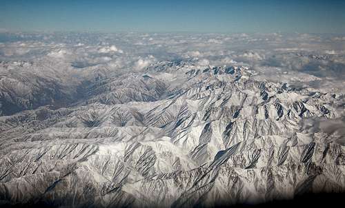
According to Afghan tradition, the name Hindukush means 'Hindu killer', but more probably it's a variant of Hindu Kuh, meaning 'Hindu mountains'. The Hindukush system is the westernmost extension of the Pamir, Karakorum, and Himalayas. Straddling the Pakistan-Afghan border, the range contains 38 summits above 7000m most of which were climbed in the 1950s and 60s. These are listed below. These peaks mark mark the north-west roof of South Asia and are the watershed between the valleys draining the Oxus and the Indus Basins. Besides these lofty summits there are still a number of unclimbed 7000m sub-peaks and numberous 6000-7000m still awaiting first ascents.
The Hindu Kush is a relatively young mountain system, contemporary with the Himalayas and similarly configured in rugged ranges with sharp peaks and deep valleys: as demonstrated by frequent earthquakes, the system is still evolving geologically. The Hindukush system stretches about 966km east to west and 240km north to south. To the East its border is marked by the Yarkhun and Mastuj Rivers in Pakistan. The 'High Hindukush contains the ranges highest mountains. As the Hindukush stretches Westward so their height diminishes and the range broadens so that from east to west it forms a funnel shape. Toward the middle, near Kabul, the mountains are around 4,500 to 6,000 meters, and in the west, they attain heights of 3,500 to 4,000 meters. The average altitude of the Hindukush is 4,500 meters.
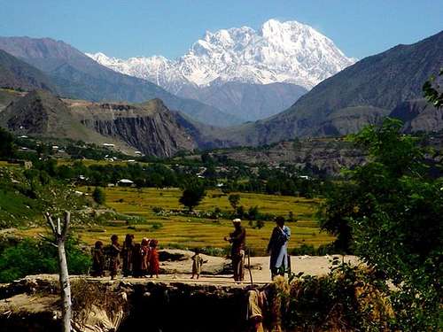
Tirich Mir from Ayun Fort
The High Hindukush
The High Hindukush range is mostly located in North-West Frontier Province (NWFP) of Pakistan and along the border with the Nuristan and Badakhshan provinces of Aghanistan.
Chitral region is considered to be the pinnacle of the Hindu Kush region. The highest peaks, as well as countless passes and massive glaciers are located here. The Chiantar, Kurambar and Tirich Glaciers are amongst the most extensive in the Hindu Kush and the meltwater from these glaciers form the Kunar river which eventually flows south into Afghanistan and joins the Bashgal, Panjsher and eventually the much smaller Kabul river. On the Afghan side the highest peaks are accessed from the solitary jeep trail that follows the northern edge of the Wakhan corridor in the Badakhan province.
Listed below are the 7000m peaks in the Hindukush. Strictly speaking there are 38 7000m summits in the Hindukush however many of these are sub peaks.
| Name | Height (m) | Height (ft) | Latitude | Longitude | Climbed? |
| Tirich Mir | 7708 | 25288 | 36o15'00" | 71o49'12" | 1950 |
| Noshaq | 7492 | 24579 | 36o25'48" | 71o48'36" | 1960 |
| Istor-o-Nal | 7403 | 24287 | 36o22'12" | 71o52'48" | 1969 |
| Saraghrar | 7349 | 24110 | 36o32'24" | 72o06'00" | 1958 |
| Shingeik | 7291 | 23920 | 36o25'12" | 71o51'00" | 1966 |
| Darban Zom | 7219 | 23684 | 36°26'36 | 71°49'48" | 1965 |
| Shingeik II | 7170 | 23523 | 36o25'48" | 71o51'00" | 1969 |
| Shakawr (Shakhaur) | 7084 | 23241 | 36o33'00" | 71o58'12" | 1964 |
| Udren Zom | 7080 | 23228 | 36o31'48" | 71o58'48" | 1964 |
| Nobaism Zom | 7070 | 23195 | 36o24'36" | 71o51'00" | 1967 |
| Shingeik III | 7050 | 23129 | 36o25'48" | 71o50'24" | 1969 |
| Urgent (Sirt-e-Urgend-e-Bala) | 7038 | 23090 | 36o39'36" | 72o09'00" | 1963 |
| Akher Tshagh (Akher Chioh) | 7020 | 23031 | 36°40'12 | 72°15'00" | 1966 |
| Langar | 7010 | 22998 | 36o34'12" | 72o03'36" | 1964 |
Tirich Mir
The highest peak in the Hindukush was first climbed by a Norweigen expedition in 1950. Whereas much of the Hindu Kush marks the Pakistan-Afghanistan border, Tirich Mir is south of the range's main crest, and projects entirely into Pakistan. The massif has eleven peaks.
Main (7708m)
East (7691m)
North (6732m)
West (7487m)
West II (7450m)
W III (7400m) (unclimbed)
W IV (7338m)
Peak 7100m (unclimbed)
Little Tirich Mir (6361m)
Ascent of Tirich Mir
Noshaq
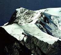
Noshaq Peak
Noshaq is the highest peak in Afghanistan and the second highest in the Hindukush. First ascent was by a Japanese expedition in 1960 via the southeast ridge from the Qadzi Deh Glacier in Pakistan. The normal route is by the West ridge which is non-technical and stright forward. Its numerous successful ascents via this route include the first winter ascent of a high Asian mountain, achieved by a Polish expedition in February 1973. Due affairs in Afghanistan no attempts were made on the mountain between 1978 and 2000. There are four peaks on the massif:
Main
Central (7400m)
East (7480m)
West (7250m)
All were climbed in the 1960s.
Noshaq 2000 expedition report
Istor-o-Nal
Istor-o-Nal means "the horseshoe" in the Khowar language although nobody knows why it has that name. The peak is located north of Tirich Mir between the Upper Tirich Mir and the Udren glaciers just across the Pakistani border. Compared to Tirich Mir and Noshaq the peak is relatively unknown. The main summit is the 3rd highest in the Hindukush and 36th highest in the world. It's height is either 7403 m or 7398 m depending which map you refer to. Istor-o-Nal was first thought to have been climbed in 1955 by an American expedition via the western ridge. However, due to cloudy weather, the pair had mistakenly climbed the highest summit of the ridge between the Rock Pinnacle and Istor-o-Nal (North). The peak was finally climbed in 1969 by a Spanish expedition by traversing south of the main peak (7303m) and then climbing over the south-east peak (7,365m) to the main peak.
The massif has eleven summits above 7000m:
Main (7407m) Climbed in a Spanish expedion in 1969.
East (7100m) Unclimbed
North (7373m) Climbed in 1967 by an Austrian team from Salberg via the North Spur. In 1976 the mountain was climbed via the West Face
North II (7372m)
North III (7300m)
North-East (7276m) Unclimbed
South (7308m) Climbed in 1969
South-East (7365m) Climbed in 1969
West (7300m) Climbed in 1970 via the SW Ridge
West II (7280m) Climbed in 1967 via the North peak
Rock Pinnicle (7200m) cimbed in 1955 by an American expedition.
Istor-o-Nal 1996 Expedition Report
 Istor o Nal
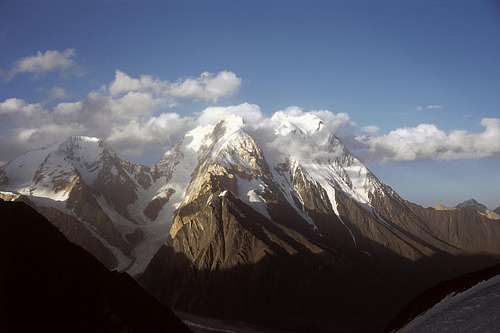
Saraghrar
Saraghrar Group
Saraghrar is the fourth highest mountain in the Hindukush and is located on the Pakistani side of the border. The Saraghrar massif is a huge, irregular stretched plateau (7000m) that is protected all around by vertical granite and ice faces. The main summits are: NE summit (7349m), NW summit (7300m), SW summit (7148m), S summit (7307m) and SE summit (7208m). Only the NW summit remains unclimbed with the SE peak having recently ben climbed in 2005 via the South peak. The base camp is at the head of the Ziwor Gol valley which is a three day trek from Zang Lasht in Turiko. The main peak was first summited in 1959 by an Italian team following a failed British attempt a year earlier.
Saraghrar SE 2005 Expedition Report
Getting to the High Hindukush
Pakistani side
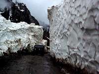
Driving over the Lowari pass (3118m)
From Peshawar
There are daily PIA flights between Peshawar and Chitral which leave early in the morning. Minibuses to Chitral leave general bus stand on the north side of GT Rd in Peshawar arriving about 12 bours later. Alternatively, the journey can be broken up by spending a night in Dir on route. The road crosses the Lowari Pass (3,208m/10,528ft), which is closed by snow from late November until May.
From Gilgit
Vehicles leave Gilgit for Chitral at least once a week (usually sunday), the journey taking about 16 hours by Land Cruiser. The road crosses the Shandur Pass (3,734m/12,251ft), which is passable for an even shorter period than the Lowari Pass.
If you think you need a visa for Bulgaria then check with your local embassy
 The Shandur Pass The Shandur Pass |
 Polo on the Shandur Pass Polo on the Shandur Pass |
Afghan side
The Hindukush's highest peaks line the southern border of the Wakhan corridor. The Corridor is accessed via Ishkashim on the Afghan-Tajik border. Special permission is required to enter the corridor (see red tape). Ariana Airlines fly twice weekly to Faizabad, the largest town of Badakhshan. There is daily public transport between to Kunduz from Kabul and Mazar-e-Sherif, Kunduz has onward public transport to Faizabad. Large expeditions should hire private transport as the public transport consists of HiAces which may or may not have a roof rack. From Faizabad there is onward transport to Ishkashim on the Afghan-Takik border. Another more challenging way to reach Ishkashim is via the Anjuman Pass at the head of the Panjshir valley and southern gateway to Badakhshan. Beyond the Anjuman Pass a jeep trail continues to Sar-e-Sang where onward transport may be possible to Baharak midway between Faizabad and Ishkashim.
The Eastern Hindukush
The Eastern Hindukush extends along the southern edge of the Wakhan corridor to point at which it broadens. On the Pakistani side the range is spread across the districts of Chitral, and Ghizar, Yasin and Ishkoman in Pakistan's Northern Area. The highest peaks at this end of the range are Lunkho-i-Dosare, 6901m and Lunkho-i-Hawar, 6895m which share a small distance from one-another. Lunkho-i-Dosare is a short distance across the Afghan border in the Wakhan corridor while Lunkho-i-Hawar lies on the Pakistan side between the Chhutidum and Noroghikun Glaciers. Lunkho-i-Hawar was first climbed by a Japanese expedition in 1967 starting from the Afghan valley of Khandut. This is also the normal approach for Lunkho-i-Dosare which was climbed a year later in 1968. Because there was no active war in the Wakhan area, there are no minefields (see 'Landmines' section below) making this a ripe place to resume climbing once security is adequate.
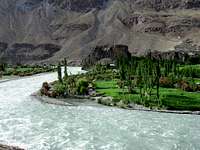 The Chitral Valley The Chitral Valley |
 The Chitral Valley The Chitral Valley |
 The Chitral Valley The Chitral Valley |
Afghan side
The Central Hindukush
The Central Hindukush is located solely in Afghanistan to the south and east of the High Hindukush range. The ranges peaks are generally located in the Badakhshan province however these also extend into the Nuristan province with a high concentration of peaks along the Badakhshan-Nuristan border. The Central Hindukush has unsuprisingly received virtually no climbing expeditons since the Soviet invasion. The highest peak in the sub-range is Koh-e-Bandaka (Bandako) at 6843m, which was climbed in 1961. Throughout the 60s at least another four routes were put up on the mountain. The second highest, Peak 6505, just across the border in Nuristan remains unclimbed to date.
The Central Hindukush is a long way from anywhere and the region's infrastructure is poor. Choice of approach is similar to the Afghan High Hindukush in that the region can be reached either via Faizabad/Ishkashim to the north or from Kabul via the Panjshir valley to the south. Mountains are most easily accessible from the Karun Wa Munjan-Zabak track which cuts right through the Central Hindukush. Those at the southern end of the Central chain can be reached via an even poorer track that leaves the Karun Wa Munjan-Zabak track just north of Magh nawal and heads south following the Nuristan border.
Nuristan is currently out of bounds for foreigner visiters. It's proximity to the Pakistan border leaves it open to cross-border insurgents. militias loyal to Gulbuddin Hekmatyar are reportedly strong in the area and local militias and feuds between rival villages meens the regions is highly volitile. There is virtually no international presence in the province.
The Western Hindukush
View for the hindu kush from the summit of Koh-i-Tej
Beyond the Central Hindukush the mountain range diverges to form numerous sub-ranges in the Western Hindukush. Only about 600km of the Hindukush system is called the Hindukush mountains. The rest of the system consists of numerous smaller mountain ranges that include the Koh-e Baba, Salang, Koh-e Paghman, Spin Ghar, Suleiman, Siah Koh, Koh-e Khwaja Mohammad, and Selseleh-e Band-e Turkestan. The Western Hindukush includes the Panjshir valley in the Parwan province. The valley's head among other peak includes Koh-i-Tej, the only peak on SP to be peak solely in Afghanistan.
Security in Afghanistan
Security continues to be volitile in Afghanistan, particularly in some of the Hindukush provinces such as Nuristan, and the US, British and Australian governments are curently advising against all travel to the country. It is not for me to say whether you should go to Afghanistan or not. There are plenty of online resources that provide up to date information and I suggest you use it before planning a trip. I visited the country in 2003 and thoroughly enjoyed my stay there however I did not partake in any climbing.
Some excellent advice is provided here
Landmines

The Panjshir Valley, Afghanistan
Following over twenty years of conflict, Afghanistan is today, not surprisingly, one of the most heavily mined countries in the world. Despite attempts at demining, there were still 10-15 million mines in Afghanistan in 1993. Afghanistan has approximately 210,000 amputees which equates to about 3-4% of the population. 30% are estimated to be children. Afghanistan compared to Bosnia, Cambodia, and Mozambique has the highest population based rates of landmine injuries and also the highest mortalities. To exacerbate the problem minefields were unmarked and few military mine maps exist. The bulk of the landmines in Afghanistan are the remnants of the Russian occupation between 1979 and 1989 during which there was intense fighting with mujahideen. Numerous mines were laid from the air, meaning mines can be found on even the remotest passes. In short you need to think extremely carefully before heading off in to the Hindukush on the Afghan side. These links show the distribution of minefields in Afghanistan.
ciet.org
HoustonChronicle.com
Red rocks indicate the presence of mines while white rocks indicate the immediate area has been cleared. There are no minefinefields in the Wakhan corridor as there was no active war in this area (United Nations, 2003. See Section 3.5.6 of the UNEP Afghanistan Wakhan Mission Technical Report).
Afghanistan's Recent Climbing History
The Afghan Hindukush was an extremely popular spot for mountaineering prior to the invasion of the Soviets. The political climate in Afghanistan remains volitile and few expeditons have visited the country in recent years.
In 2003, Carlo Pinelli, director of Mountain gained permission to lead an expedition to Noshaq, the highest mountain is Afghanistan. The team were successful in reaching the main summit making the first ascent since 1978. One of the main problems the mountain wilderness expedition faced was finding a route through th anti-personnel mine fields that guarded the approach valley. There was also the problem that porters were unhappy to go above the snow line and that for a climbing infrastructure to develop, local help at high-altitude would only be practical after lengthy training.
The only other relatively recent ascent I know of in the Afghan Hindukush is Koh-e-Tej. There have been a couple of other ascents of smaller peaks in Afghanistan however these were in the Pamir and not the Hindukush...
In late spring 2006 Americans Doug Chabot and Mark Jenkins climbed Koh-e-Barbar (6078m) in the Wakhan corridor. This is believed to be a first ascent. It also marks the first ascent of any unclimbed peak in Afghanistan since the Soviet invasion. The peak lies above the village of Parwakshan. The pair set up base camp at 3156m and reached the summit in 48 hours and climbing was not too difficult. There is a good online report here.
Possibly the second virgin peak to be climbed since the Soviet invasion was Koh-e-Maghrebi (6040m), climbed by Spanish mountaineers David Cejudo Fernandez and Luis Miguel Lopez in August 2006. This was actually in the Afghan Pamir not the Hindukush but is an interesting peak to note on this page since all the same.
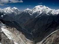
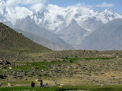 Hindukush rising about the Wakhan Corridor
Getting to Pakistan & Afghanistan
Pakistan
Islamabad is the international gateway for those arriving by air. Emirates also operate flights to Peshawar which is more convenient. Chitral is the administrative centre for the region on the Pakistani side of the border, which has connections with Peshawar to the south and Gilgit to the East.
Afghanistan
A select number of airlines fly to Kabul.
•Air Arabia Bahrain
•Ariana Afghan Airlines
•Azerbaijan Airlines
•Emirates
•Indian Airlines Delhi
•Kam Air Dubai & Almaty
•PIA
Alternatively fly to Islamabad or Peshawar and cross the Khyber Pas into Afghanistan. To do this you will need permission to travel through the tribal areas that line the Afghan-Pakistan border. Permits are issued by the Khyber Political Agent's Office (9am-2.30pm) in a matter of minutes. Take your passport and the Rs120 fee. You must also have a driver pearranged as it is forbidden for foreigners to travel through the tribal areas on public transport. Take your driver with you to the Kyber Political Agent's Office as without him you'll be denied permission. If you are leaving the same day, you will be issued with an armed escort.
Upon crossing the border take a HiAce or share taxi to Jalalabad and connect with another to Kabul.
Afghanistan can easily be reached from Tajikistan with crossings at Amu Darya and Ishkashim.
There are no open borders crossings between the Pakistani side of the range and the Afghan side of the Hindukush. During the civil war crossings were relatively easy however since 09/11 the border has been largely sealed. If you attempt a cross-border route without explicit permission for that route, you are subject to being shot at, taken into custody, and accused of crimes. In 2005, everyone who attempted an international border crossing without permission was detained by authorities.
 Mountains North of Kabul
Red Tape
Visas
A valid visa is required for both countries.
Pakistani visas
Visas are NOT issued at the airport and must be obtained prior to arrival. Some embassies such as those in Central Asia are reluctant to issue visas and advise you to obtain them from your home country. A single-entry tourist visa is valid for 3 months from the date of arrival in pakistan and for 6 months from the date of issue. Some visas are only valid for 3 months from the date of issue so check if necessary when applying. Visa prices vary. Americans pay the most for their visa whilst Japanese get theirs free! Visa extensions and reentry stamps are virtually impossible to obtain.
Afghan visas
Afgan visas are generally easy to obtain however at some embassies (eg Tehran!) visas are virtually impossible to obtain. Best bet is to apply in either Peshawar or Mashhad. Some embassies (eg Dushambe) may require a letter of introduction which will need to be sought from a local travel agent.
Climbing Permits/Royalties
Pakistan's Ministry of Tourism has decided to maintain royalties at 10% of normal rates for peaks above 6500m during 2007 in the districts of Chitral, Ghizar, Yasin and Ishkoman. Royalties are only 5% the normal rate for those wishing to climb in winter (december to february). Royalties per expedition are based on a party of 7. Persons additional to this number will be subject to an additional royalty fee.
Occasionally, permits have been refused on a large scale for reasons of border security. This happened in 2006 when restricted parts of the Chitral Valley were closed to foreigners. This obviously included mountains of the High Hindukush such as Tirich Mir, Noshaq, Istor-o-Nal and Sraghrar. Having initially issued a number of permits these were revoked at short notice.
| Elevation | Normal Fee | Fee for 2009 | ||
| Royalty per expedition | Additional royalty per person | Royalty per expedition | Additional royalty per person | |
| 7501 - 8000m | $9500 | $1500 | $950 | $150 |
| 7001 - 7500m | $4000 | $500 | $400 | $50 |
| 6501 - 7000m | $2500 | $300 | $250 | $30 |
| 6000 - 6500m | $1500 | $200 | No fee | No fee |
There are no climbing permits in afghanistan. Afghanistan still lacks any significant central administation and tribal law still reigns supreme in rural areas. In order to climb you need to have the permission from someone with sufficient importance and standing in the local community. That way if there is any issues about you being there they can back you up.
d permission
Permission for Wakhan region is usually a handwritten letter in Dari from the commander of the Border Security Force in Ishkashim. The letter must specifically state where you want to visit in the Wakhan corridor. You will be asked by authorities to show this letter and will be sent back to Ishkashim if you don't have it.
To request permission, first contact the Afghan Tourism Organization (ATO) in Kabul who will act as the liaison with government ministries and issue a letter that you will present at the commander's office in Ishkashim. ATO's office is near Kabul International Airport on the right-hand side of the road 100m before the roundabout when coming from the city.
Doug Chabot who recently climbed Koh-e-Bardar remarked that while Afghanistan may be close to being ready to accept climbers, the logisitcs are curently a nightmare.
Trekking Permits
Border areas on the Pakistani side are generally in a 'Restricted Zone' and a trekking permit is required. This must be applied for through a trekking agency. A guide must be hired for the duration of the trip while in a restricted area. Other areas fall within a restricted zone but require no permit. Permission to visit the area is granted by the DC in Chitral.
List of open/restricted zones
A trekking permit is not required in Afghanistan.
Climbing Conditions
Climbing conditions in the Hindukush are similar to the Karakoram. The one major difference is that while Karakoram rock is a mixed bag Hindukush rock is nearly always bad. The further west you climb in the range the more crumby it gets. Leave the micronuts at home! People don’t visit the Hindukush for rock but for the snow, ice and mixed climbs, which can be excellent when the right conditions prevail. Summers in the Hindukush can be hot, sometimes even at night with temperatures not dipping below zero. This can cause obvious problems when trying to do technical routes as snow quickly becomes soft and ice poor quality, often sugary. As with any high mountain range patience to wait for the right conditions is a vital factor. An advantage of the warm weather is that it is possible to pack lighter than for a peak of comparable height in the Nepalese Himalaya, Tian Shan or Pamir. Weather also tends to generally be more stable than the ranges to the north. Snowfall can occur at any time although it tends to be quite a mild affair during the summer months. At high altitudes unstable snow pack can still quickly build up after an extended period of bad weather.
Camping
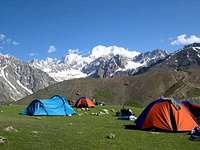
Camping on Tirich Mir Barum route
There are no problems with camping on the Pakistani side. Even many guesthouses will let you camp on their premises for a small fee.
In Afghanistan camping anywhere in the vacinity of the local population without their expressive permission is not recommended. Once off the main trails there's generally no one to object you being there so there shouldn't be any problems.
Flora

The Koh-e-Baba mountains. Bamiyan, Afghanistan
These mountainous areas are mostly barren, or at the most sparsely sprinkled with trees and stunted bushes. True forests, found mainly in the easternprovinces of Nuristan and Paktiya, cover barely 2.9 of the country's area. Even these small reserves have been disastrously depleted by the war and throughillegal exploitation. The forests are in fact in a crisis situation. A 1996 a FAO report estimated that of the 4.7 million acres of forests existing at thebeginning of the war, in 1979, considerably less than one million acres survive today. South of Chitral there is still significant ak forest cover however this has been heavily depleated in the proximity of roads.
When to Climb
Weather, though hot in the summer and snowy in the winter, is generally predictable and stable. The mountaineering season starts from June and finishes by September. July and August are considered the best months to climb in Pakistan. Outside these months snow can be problematic at high altitude.
7 day weather forecast for Chitral
Maps
AMS NJ43-14 Mastuj (1:250,000) Covers Chitral & Ghizar
Topographical map of Badakhshan (main)
Topographical map of Badakhshan (south)
Topographical map of Badakhshan (Wakhan - Noshaq region)
Topographical map of Badakhshan (Wakhan - Saraghrar region + Eastern Hindukush) (+Hindu Raj)
Badakhshan provincial Road Map
Nuristan Provincial Road Map
General map of border area
Map Stockists
UK
The Map Shop
Stanfords
Cordee
USA
Chessler Books
Map Link
Omni Resources
Germany
Aree Gaul
Deutcher Alpenverein
GeoCentre ILH
Italy
Liberia Stella Alpina
External Links
1970 Imperial College Hindu Kush Expedition
Afghan Wakhan Mission Technical Report
AIMS News, info, maps
Kabul Caravan
Steve Razzetti Stunning photos of the Hindukush.
Wakhan Corridor Expedition Report
A Short March in the Hindukush Article in Alpinist magazine
gabem - Jan 20, 2011 6:52 am - Hasn't voted
Language / De Facto Authority vs. Actual AuthorityJust a couple quick notes. Persian should be changed to Dari. Also, without having been to this region, but having knowledge of the current situation of the AFPAK border from the Afghan side, it might be prudent for a potential expedition to also secure permission from the nearest commander of the Afghan Border Police or Afghan National Police. I would think a Kandak commander would be sufficient for ABP and District Chief of Police for ANP. Note: great page with great info :) hope to climb here someday
brucehooker - Feb 29, 2016 12:08 pm - Hasn't voted
Correction for linkThe link given to : 1970 Imperial College Hindu Kush Expedition has changed, it is now: http://www.windmillweb.info/climbing/HinduKush/HinduKush.htm Thanks.
BigLee - Mar 21, 2016 9:03 am - Hasn't voted
Re: Correction for linkThanks for that