1 - Overview
![View towards Muttler]() View towards Muttler and Fluchthorn View towards Muttler and Fluchthorn |
The Samnaun Group is a small mountain range in the heart of the Alps. Like its neighbours, the
Ferwall Group to the west, the
Silvretta and
Sesvenna Groups to the south and the
Ötztal Alps to the east it is part of the
Rhaetian Alps, a stretch of mountain ranges which took its name from its original inhabitants, the Rhaetians. Far more interesting than its mountains the history of the area is what sets the area aside, especially the Samnaun Group.
The original Rhaetians lived in the area during the times of the Roman emperor Augustus, who – in the persons of his adopted sons Drusus and Tiberius – conquered the people and submitted them to Roman rule. As nearly everywhere in the Roman empire locals and Romans got mingled resulting in a new people, the Rhaeto-Romanians. More important from today’s point of view, languages got mixed too, forming the various Rhaeto-Romanian idioms, some of which survived until our times. The Ladinian idioms of the central Dolomites or the Rhaeto-Romanian language of the Swiss south-eastern cantons are the best proof. After the downfall of the Roman empire Bajuwarian and Walser tribes migrated into the region pushing aside the original inhabitants and making German the language of choice in most parts of the area.
The Samnaun area was at the heart of all the changes during history, mostly because of its proximity to one of the most important north-south passes in the Alps, Reschenpass / Passo di Resia. For a long time the pass was more important than the Brenner pass in the east, especially during the time at which the counts of Tirol still resided in Dorf Tirol near Meran / Merano. It retained its strategic importance through all the ages and today is the point (nearly) where the countries Austria, Italy and Switzerland meet. The Samnaun Group is located to the north-west of that point.
Samnaun Group as seen from the Kieler Weg hiking trail in Ferwall Group |
The mountain range derived its name from Samnaun Village and the associated valley, which splits it into two parts, a long northern main ridge and a higher but shorter southern side ridge, the Muttler Group. The original name of Samnaun was Samignum, a weird form of St. Magnus – which is the patron saint of the church of Samnaun village. Samnaun Valley belongs to Switzerland though there are no roads nor passes leading into the country. Thus the valley retained an expatriate status in fact remaining a duty free haven for a long time.
The mountains – like neighbouring Ferwall – are made up from Gneis. They easily reach elevations of 3000m but don’t exceed that mark by much. The Samnaun Range is one of the driest regions of the Alps (being surrounded by higher groups which take much of the humidity away) and thus you can only find tiny glaciers here. The hot summer of 2003 did its part to make them (almost) all vanish. The long northern main ridge is made up of mountains which - with a few exceptions – can be climbed rather easily. The ridge has numerous side ridges to both sides and offers quite a number of hiking trails. In contrast the southern Muttler Group only offers two traverse trails and the Muttler normal ascent. For everything else you need alpinistic experience.
In recent years the Samnaun Group has become a well known ski destination in winter. The northern slopes near Ischgl and See offer lots of ski runs as do the western slopes around Serfaus. Samnaun also has a couple of runs. The result of this is a number of ski and chair lifts, some of which are also operated in summer. Consequently the mountains in the direct vicinity of the lifts often get crowded, especially the ones around Ischgl. For solitude head for the Muttler Group, where so far no ski development has taken place.
2 - The Samnaun Group on SP

Interactive map of the Samnaun Group. Click the numbers to be directed to the respective sections on this page |
|
The Samnaun Group consists of two ridges, both of which run from suth-west to north-east. The northern ridge is the longer one while it doesn’t rech the elevations of the shorter southern one, the Muttler Group. Generally the northern ridge is divided into two parts, east and west of Flathjoch Pass.
The southern Muttler Group is divided from the northern main ridge by Samnaun Valley, which culminates in Zeblasjoch Pass (Samnauner Joch), one of the important high passes of the Rhaetian Alps. It is by this pass, by which Samnaun Valley was first populated and which for a long time remained the only access route into the valley.
- Northern Main Ridge East
- Northern Main Ridge West
- Muttler Group
3 - Northern Main Ridge East
The northern Samnaun Ridge is generally divided in two parts, separated at Flathjoch Pass to the south-west of Hexenkopf. The eastern part branches out into two ridges at its far north-eastern end The Seekopf Ridge in the north, the Sattelkopf Ridge in the east. Both combine near Furgler, the easternmost 3000er of the Samnaun Group. From there it is a short main ridge towards Hexenkopf (which is the highest summit of this part of the main ridge) with a couple of short side ridges north and south. The Sattelkopf Ridge is home to all the Serfaus ski runs and is consequently heavily developed.
3.1 - Seekopf Ridge
- Zirmegg (2073m)
- Dialkopf (2398m)
- Gatschkopf (2588m)
- Gigglerspitze (2614m)
- Kegelkopf (2837m)
- Wasenkopf (2825m)
- Seekopf (2850m)
- Gamsbergkopf (2821m)
- Gamsbergspitze (2839m)
- Rotpleiskopf (2936m)
- Kübelgrubenkopf (2870m)
3.2 - Sattelkopf Ridge
- Matekopf (2200m)
- Frommes (2247m)
- Schönjöchl (2493m)
- Zwölferkopf (2596m)
- Oberer Sattelkopf (2596m)
- Hinterer Sattelkopf (2670m)
- MittlererSattelkopf (2160m)
- Unterer Sattelkopf (2091m)
- Vorderer Brunnenkopf (2682m)
- Hinterer Brunnenkopf (2642m)
- Planskopf (2804m)
- Plansspitze (2766m)
- Plansturm (2600m)
3.3 - Main Ridge
- Glockspitze (2846m)
- Blankakopf (2892m)
- Medrig (2568m)
- Kleiner Furgler (2897m)
- Furgler (3004m)
- Lawenskopf (2877m)
- Südlicher Arrezkopf (2845m)
- Nördlicher Arrezkopf (2860m)
- Hexenkopf (3035m)
3.4 - Lafairschtal Ridges (S)
- Lazidkopf (2346m)
- Pezid (2770m)
- Riefenkopf (2654m)
- Hinterer Heuberg (2578m)
- Vorderer Heuberg (2356m)
- Praiswand (2411m)
- Laderberg (2365m)
- Theierjoch (2091m)
- Perflkopf (1838m)
3.5 - Plattkopf Ridge (N)
- Stillegg (2570m)
- Stillkopf (2889m)
- Plattkopf (2893m)
4 - Northern Main Ridge West
The western part of the northern main ridge shows several more side ridges than does the eastern part. Mountains are generally higher but still only two reach more than 3000m – Vesulspitze (3089m) and Bürkelkopf (3055m). Both are located right in cntre of the subgroup between Flathjoch pass and Zeblasjoch Pass. East of Bürkelkopf you find the Ischgl ski runs and with Greitspitze and Salàaser Kopf there are two very popular summits which can be easily reached from the chair lifts.
4.1 - Main Ridge
- Masnerkopf (2828m)
- Gmaierkopf (2914m)
- Zanderskopf (2831m)
- Martinskopf (2736m)
- Oberer Malfragkopf (2776m)
- Unterer Malfragkopf (2654m)
- Grüblekopf (2894m)
- Spilitspitze (2754m)
- Visnitzkopf (2745m)
- Bürkelspitzen (2933m, 2921m)
- Bürkelkopf (3033m)
- Flimspitze (2929m)
- Greitspitze (2850m)
- Salàaser Kopf (2744m)
- Höllenspitze (2799m)
- Palinkopf (2864m)
4.2 - Minderkamm Ridge (S)
- Minderskopf (2780m)
- Blautalrücken (2834m)
- Gamspleiskopf (2792m)
- Hoher Kopf (2447m)
- Praiskopf (2371m)
4.3 - Frudigerkamm Ridge (S)
- Frudigerkopf (2822m)
- Blauwand (2816m)
- Frudigerkopf (2709m)
- In der Keil (2679m)
- Rotspitze (2678m)
- Muterköpfli (2525m)
- Kreuzjochkopf (2698m)
4.4 - Kreuzjoch Ridge (N)
- Hinteres Kreuzjoch (2853m)
- Schwarzer Kopf (2664m)
- Vorderes Kreuzjoch (2845m)
- Bergliskopf (2595m)
4.5 - Karlesspitze Ridge
(N)
- Mittagspitze (2249m)
- Lahngangkopf (2471m)
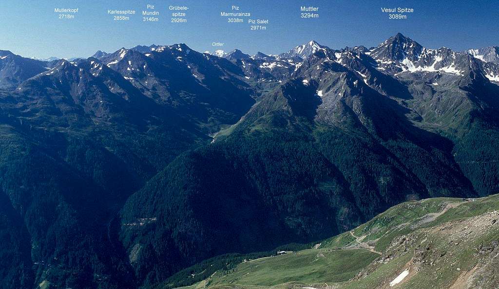
- Mutlerkopf (2718m)
- Schafpleiskopf (2707m)
- Karlesspitze (2858m)
- Ochsebnekopf (2888m)
- Grüblespitze (2933m)
4.6 - Alp Trida Group (S)
- Munt da Chierns (2690m)
- Piz Urezza (2100m)
- Piz Munschuns (2658m)
- Vesulspitze (3089m)
- Velillspitze (2704m)
- Alptrider Kopf (2848m)
- Piz Crappa Grischa (2800m)
- Piz Ot (2758m)
5 - Muttler Group
The triangular range around the Samnaun Group’s highest summit, Muttler (3294m), though much smaller than the northern main ridge, is much more impressive. Besides Muttler six other mountains reach more than 300m in elevation with various others stopping short slightly below that level. The group is solitary, there are only two traversing trails east and west of Muttler and a hiking trail onto the outlying Piz Arina, a gorgeous lookout peak. Here in the rhaetic heartland you can still find original mountain names, some of which resound oddly familiar if you think of the Ladinian names of some of the Dolomite peaks. Compare the local Spi da Chöglias with the Dolomite Spiz di Tariciogn in the Rizzoni Crest far to the south and east. Both languages share the same rhaetioromanian origin. The Muttler Group is composed of a single ridge running from east to west with a few short side ridges to the north. Only Piz Arina is located apart to the south of the group. A short ridge to the east can be counted as a prolongation of the northern main ridge
5.1 - East Main Ridge
Piz Rots (Vesilspitze 3097m)
Spi da Chöglias (2925m)
Piz da Val Gronda (2811m)
Piz Fenga Pitschna (2725m)
Piz Davo Sassè (2791m)
Piz Calchogns (2792m)
5.2 - Muttler Ridge
Sulnerspitz (3034m)
Piz Chamins (2927m)
Stammerspitz (3254m)
Piz Nair (3294m)
Muttler (3294m)
Piz Salèt (2971m)
Piz Malmurianza (3038m)
Spi dal Mundin (2945m, 3084m, 3106m, 3115m)
Piz Mundin (3146m)
Mundinturm (3120m)
Mundinnadeln (3110m)
Piz Alpetta (2974m)
Piz Murtera (2580m, 2600m)
Piz Mezdi (2920m)
Teufelszacken (2289m)
5.3 - Schwarzwand Ridge (N)
Schwarzwandspitze (2871m)
Piz Motnair (2732m)
Pizzet (2543m)
5.4 - Piz Arina (S)
Piz Arina (2828m)
6 - Getting There
The nearest international airports are Innsbruck in Austria, Milano and Verona in Italy and Zürich in Switzerland, though only Innsbruck is real close by. Consequently the itineraries from the other airports are far more lengthy and complicated.
- From Innsbruck
Simply take motorway A12/E60 west towards Landeck. There take B184 towards Reschenpass for the eastern part (Oberinntal Valey) of the group or B188 for the western part (Paznauntal Valley).
- From Zürich
Take motorway A3 east to Vaduz. At exit Bad Ragaz take B28 to Davos and across Füelapass to Susch. Here turn on B27 north which will take you to Finstermünzpass and the eastern part of the Samnaun Group. Alternatively at Bad Ragaz turn north onto motorway A13 to Vaduz where you cross over via B191 to Feldkirch and motorway E60 east. This will take you across Arlbergpass and on to Landeck.
- From Milano
Take the ring motorway north and leave for SS36 north. It will take you by Monza and Lago di Como until you reach Chiavenna. There turn Onto SS37 east in direction of St. Moritz. The road turns into B27 on the Swiss side of the border and takes you on over Finstermünz Pass to the eastern part of the Samnaun Group.
- From Verona
Take Motorway A22 (Brenner Motorway northward until you reach Bozen / Bolzano. There turn onto SS38, Vinschgauer Staatsstrasse, which takes you to Schluderns and from there on northwards to Reschenpass and the Samnaun Group.
7 - Red Tape
There is no red tape to speak of. The usual rules apply – leave plants and animals, take your refuse, keep dogs on leash etc. Also, you are in the border region between three European countries and though Italy and Austria belong to the EU, Switzerland doesn’t. Keep your Pass or ID handy.
8 - Mountain Huts & Refuges
There are only two handful of huts in the Samnaun Group, most of which are located near the ski runs of IIschgl and Serfaus. There is only one long trekking route in the group which traverses the northern main ridge from Heidelberger Hütte in the south-west to Landeck in the north-east. The treck can be done in three days - or two if you are in for long hikes.
| Refuge / Hut | Height | Summer | Winter | Tel. | Thumbnails |
| Landecker Skihütte | 1760m | n.a. | n.a. | +43/5442/63057 | |
| Ascher Hütte | 2256m | beg. July – mid Sept. | closed | +43/5441/8330 | |
| Kölner Haus | 1965m | June – Sept. | Dec. – Easter | +43/5476/6214 | |
| Hexenseehütte | 2585m | June – Sept. | Dec. – Easter | +43/5476/6214 | |
| Alp Trida | 2263m | beg. July – mid Oct. | beg. Dec. – mid May | +41/81868/5120 | |
| Idalpe | 2311m | all summer | all winter | n.a. | ![]() |
| Bodenhaus | 1848m | mid June – beg. Oct. | mid Dec. – mid April | +43/5444/5285 | |
| Heidelberger Hütte | 2265m | end June – beg. Oct | mid Dec – mid May | +43/5444/5418 | ![]() |
| Hof Zuort | 1711m | June – end Oct. | Christmas – Easter (Jan closed) | +41/81/8663153 | |
9 - Accommodation
Each of the towns and villages of the area has a homepage with the possibility to book hotel rooms and apartments. Follow one of the links below.
9.1 – Paznaun Valley
9.2 – Oberinntal Valley
9.3 – Graubünden
10 - Weather Conditions
In addition to the weather information on the sites you find under accommodation you can look up these sites:
11 - Maps & Books
11.1 – Maps
- Digital Maps
- Regular Maps
- Landeck-Nauders-Samnaungruppe
Kompass Map WK 42
1:50.000
ISBN: 3-85491-048-7
- Silvretta-Verwallgruppe
Kompass Map WK 41
1:50.000
ISBN: 3-85491-047-9
- Schweizer Landeskarte, available at German Alpine Club
- SLK 1179 Samnaun, Art.Nr.: 141179
11.2 - Books
- Arlberg – Paznaun
Herbert Mayr
Rother Verlag
ISBN: 3-7633-4121-8
- Unterengadin
Rudolf Weiss / Siegrun Weiss
Rother Verlag
ISBN: 3-7633-4043-2
- Samnaungruppe
Paul Werner / Ludwig Thoma
Alpenvereinsführer
Rother Verlag
ISBN 3-7633-1241-2

 21169 Hits
 92.59% Score
 39 Votes
 View towards Muttler and Fluchthorn