
|
|
Area/Range |
|---|---|
|
|
49.19600°N / 19.84130°E |
|
|
Hiking, Mountaineering, Ice Climbing, Mixed, Scrambling, Via Ferrata, Skiing |
|
|
Spring, Summer, Fall, Winter |
|
|
7375 ft / 2248 m |
|
|
Overview
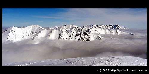 View from Baranec, first two side ranges north-south belongs to Západné Tatry, behind them there are Vysoke Tatry, on the right Krivan (2495 m).
The Western Tatras (Západné Tatry in slovak, Tatry Zachodnie in Polish), belong to the Carpathian range and are the second highest mountain range in Slovakia and Poland.
As their name suggest, they belong to the Tatras range and lie just next to the High Tatras.
Their name in Hungarian has two modifications: Liptói-havasok or Nyugati-Tátra.
Their highest peak is Bystrá (2248 m).
 Ziarska dolina. March 2006.
The range starts on the west from pass Hutianske sedlo (904 m), connecting to the Chočské Vrchy and ends east joining the High Tatras at the pass Laliove sedlo (1947 m). The length of main ridge oriented in west-east direction is 37,6 km. On one part of the main ridge is the Slovak-Polish border.
The Western Tatras are divided in 6 side-ranges, beginning at the main ridge and leading to the south. They divide the valleys Jalovecka dolina (dolina = valley), Ziarska dolina, Rackova dolina, Jamnicka dolina, Kamenista dolina, and Ticha dolina.
There are only two side ridges to the north on Slovak side that divides valley of Studeny potok. The Western Tatras have an asymmetrical shape, so that the highest peaks are not in the main ridge, but in side ridges.
Moreover, north side ridges are lower than the south ones. The altitude difference varies from 700 to 2248 m and the area of about 260 out of whole 380 square kilometres belong to both TPN and TANAP national parcs (Poland and Slovakia).
The Western Tatras are mainly made of granite, gneiss, and crystalline shale, as well as limestone on the northern side, especially in Poland.
They are also partly formed by former glaciers that were mainly in Jamnicka dolina and Rackova dolina. Smaller glaciers were in Kamenista dolina, Bystra dolina, and Ziarska dolina.
Six mountain lakes Rohacske plesa lie in altitudes varying from 1370 to 1719m, on the north side of the Western Tatras in Rohacska dolina. The largest one is the lowest Dolne Rohacske pleso with the area covering 2.2 ha, depth 6.5 m. The deepest is Horne Rohacske pleso – 12.5 m. Other mountain lakes are Jamnicke plesa (the end of Jamnicka dolina), Rackove plesa (the end of Rackova dolina), small lake in Gaborova dolina, and others. There are also several waterfalls.
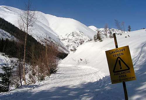
A lot of avalanches occur in Western Tatras and as a result of their slat slopes and steep shapes. According to their size and periodicity, it is the most avalanchous range in Central Europe.
Most of the avalanches fall down in Jamnicka dolina, where 12 avalanche couloirs are known. The longest one is from Baranec and the length of avalanche route is about 2550 m with altitude difference 970 m.
Subgroups of the Western Tatras

1: Sivy vrch area : beginning of Western Tatras from the west, area around the peak Sivy vrch (1805 m) and next to the Chočské Vrchy. Osobita can also be included in this westernmost group.
2: Rohace : the rockiest part, from Brestova to Volovec, including Ostrý Roháč, Plačlivý, Baranec, Baníkov
3: Liptovske Tatry : The southern valleys and peaks, including Jakubina, Bystrá , Klin.
4: Polish Western Tatras : from the border, (Tomanova dolina and Ticha dolina) to the limestone peaks on the northern side: Kominiarski Wierch, Czerwone Wierchy, Kasprowy Wierch (big ski resort), Giewont, Dolina Chocholowska, Dolina Koscieliska...
5: Liptovske kopy : From west bordered by Ticha dolina (yellow and red marked tourist path), from east by Koprova dolina (green marked tourist path). Peaks are not accessible by tourist paths. There is a geographic debate whether they belong to Western or High Tatras. Western for their shape, but more in High Tatras for their location behind Ticha dolina.
Getting There
by air: airport Bratislava (SK), Viena (AT) or Prague (CZ), closest is the Poprad airport without everyday service, from airports by train, bus or car to the city Liptovsky Mikulasby bus or train: direct trains and buses from all major Slovak cities to Liptovsky Mikulas, then by car or bus to all major entry points Ziar, Jalovec, Zuberec, Podbanske. Everyday service is provided by SAD (Slovenska autobusova doprava).
Red Tape
TANAP – Tatransky narodni park is divided into two main groups, East Tatras consisting of Vysoke Tatry/High Tatras and Belianske Tatry, and West Tatras, that were added to TANAP in February 1987. Thus, the condition for visiting the Western Tatras are the same as for the rest of TANAP.Source: Information for visitors of TANAP.
Members of any of UIAA member can climb, ski, etc. in specified areas, see below. Non-UIAA members are permitted to use ONLY MARKED TOURIST TRAILS or to be accompanied by TATRA' MOUNTAIN GUIDE.
The National Park is the heritage of all mankind. Mount Krivan (2495m) is the national symbol of the Slovak people. Since 1993 the mountain range Tatras, together with the Polish part of the National Park, has been identified as natural, biospheric, reserve of UNESCO. Whilst enjoying your visit in the National Park, please help us to protect its natural beauty. Information notice boards about the National Park serve you, the visitor - please do not damage them.
1. In order to enjoy your visit please use marked hiking tracks, footpaths and cycling tracks as well as Tourist Information Centres. Cycling tracks
2. Picked flowers will wither, captive butterflies will die, chicks of an eagle could fall from their nest if disturbed. Therefore touch the nature by your heart only.
3. In order to protect the nature and to ensure your safety, hiking tracks in the mountains are not accessible to public between 1 November and 15 June. Closure of hiking paths
4. Enjoy your hiking in the daytime, between an hour after sunrise and hour before sunset.
5. Hiking away from marked tracks, under the supervision of experienced guides, is available between 16 June and 31 October. Hiking away from the marked tracks
6. In order to protect endangered species of birds of prey, paragliding and using rogallo is permitted only in specifically
designated areas. Gliders nad paragliders
7. It is not permitted to camp or bivouac anywhere in the National Park. It is prohibited to light fires anywhere in the National Park other than in designated sites in tourists villages.
8. If you are enjoying your stay in the National Park with your pet dog then the dog should always be on a lead and muzzled. In specifically designated nature reserves dogs are not permitted to enter at all.
9. Peacefulness of nature is there for you to enjoy. It should not be polluted either by lights effects or loud music, or any other noises.
10. The National Park provides also for winter sports such as alpine and cross-country skiing on designated slopes and tracks as well as mountain and rock climbing, and ski-alpinism in purposely built facilities where picnic areas are set aside for an open fire barbecues.
Alpine skiing
Cross country skiing
Ski-alpinism
Climbing and rock-climbing
11. Please do not pollute the environment. Take your rubbish home with you. To avoid fires please refrain from smoking during dry periods.
12. Protect the underground beauty of the nature. Do not try to enter inaccessible caves and gullies
Border
Since January 2008, both Poland and Slovakia belong to the Schengen european space, hence crossing the border is now allowed in almost all West Tatras (more precicely from June 15th 2008 which corresponds to the end of the slovak winter closure).Let's mention anyway that Volovec and Rysy) were however allowed for hikers long ago before that.
But don't forget to always carry your papers in your rucksack if you plan to venture in the other country, even returning to the starting point.
Highest peaks
1. Bystrá (2 248 m)2. Jakubiná (2 194 m)
3. Baranec (2 184 m)
4. Baníkov (2 178 m)
5. Klin (2 176 m)
6. Blyšť (2 169 m)
7. Pachoľa (2 166 m)
8. Nižná Bystrá (2 153 m)
9. Príslop (2 145 m)
10. Hrubý vrch (2 137 m)
Informations for potential SP volunteers: the most important missing peaks of this area in SP are: Konczysty Wierch, Salatin, Brestova, Kamienista. But we also face a lack of photos...
When to climb
 Near the summit of Baranec. March 2006.
Summer
Hiking in the Western Tatras is allowed from the 15th of June till the end of October. In fact, there are several regulations, see RED TAPE section.
There are many well marked tourist path in valleys and ridges. Marks are in red (main ridges), blue, yellow, and green colours of a horizontal stripe shape rounded above and below by white stripe. Marked tourist paths for cross-country skiing are of similar main colour surrounded above and below by yellow stripe. The same shape as cross-country skiing marks, but twice bigger has marks for cyclist paths.
Main ridge - profile and description of main ridge of the Western Tatras
 Skiing from Baranec, on the background Ziarske sedlo and Smrek.
Winter
Cross-country skiing in several valleys, for example Ziarska dolina and Rohacska dolina.
 Skiing from Baranec - highest part.
Ski-alpinism/backcountry skiing - there are three areas opened for this activity:
Babky - bordered by ridge Babky (1566) - Preduvratie pass (1585 m) above Jalovecka dolina
Spalena dolina - between peaks Brestova and Salatin above Spalena dolina ski-resort
 Lower part of skiing from Baranec.
Ziarska dolina - the best one, above chalet Ziarska chata
Ziarska dolina ski descends - really great source for ski-alpinism in Ziarska dolina, photographs with routes, difficulties of descend, steepness of slopes, etc. for a pity, text is only in Slovak language.
the map of avalanche areas in Ziarska valley
Mountain chalets, refuges, camping, and huts
Chalets (mountain hotels accessible by road)

Chata Zverovka
The first small chalet for 36 chalet was opened in that area in 1923. Other chalet named after founder Matasak was build up in 1928. It takes only 6 weeks of construction as the chalet was build up as a training of 1st and 2nd army mountain troops from Dolny Kubin. Zverovka was burned off by German troops during the World War II in December 1944. New chalet was opened in 1953.
Note that the hut marked "Bývalá Ťatliakova Chata" on some old maps, upper in the Rohacka valley is not a hut anymore but a place where they sell refreshments in summer.
Contact: Hana Čaučíková, Zverovka 375, 027 32 Zverovka, Slovakia
tel: ++421 43 5395 106 fax: ++421 43 5395 327 mobile: ++421 905 973 201
email: zverovka@chatazverovka.sk
web: Chata Zverovka
Chata Koziar
located at the entrance of Ziarska dolina. Chata Koziar has 75 bed, classic Slovak old fashioned restaurant – koliba with great meals.
Contact: Žiar 218, 032 05 Slovakia
tel: ++421 44 558 61 30, ++421 908 460 300
e-mail : koziar@nextra.sk
web: Chata Koziar
A lot of other chalets are described at: Chalets in the Western Tatras
Mountain refuges

Žiarska Chata (1350 m)
It is situated in the centre of Ziarska dolina on the south slopes of the range. This valley is one of the most famous and most visited mountain valley. A lot of marked tourist paths are around this chalet that increase importance of chalet for visitors. In 2006, a reconstruction of the whole building will be held there. Chalet provides 46 places in restaurant, 34 beds and 20 places in winterraum. Several avalanches hit Ziarska chata in winter and spring time in last years. A route to Ziarska chata is also threaten by avalanches, so check the avalanche forecast before visiting this valley!
First Žiarska chata was build in 1939 and served till December 1944, when it was burned off by German troops during the World War II. The chalet was newly build after war and it was rebuilt several times.
Access from:
Ziar – parking place at the embouchure of the Ziarska dolina, 5,3 km to the chalet by road.
Contact: TJ Družba Smrečany – Žiar, Miroslav Matejka, Žiar 110, 032 05 Smrečany, Slovakia
tel: ++421 44 559 15 25
web: Ziarska chata

Chata pod Náružím (1420 m)
It is located under Mala kopa peak in forest part. Blue marked tourist path from Bobrovec via Mala kopa to the main ridge leads next to the chalet. Chalet provides 30 beds and 20 places in winterraum. Opening hours: in summer season July – August constantly, the rest of the year just on weekends or on previous agreement with cottager.
Access from:
Jalovec – bus station, yellow foot path, then change to blue marked foot path.
In case of emergency, if the refuge is closed, you can shelter in a hut nearby, Bývalá kolibka na Červenci
Contact: Ivan Ogáry: +421(44)5596964, +421 (902) 622 611, or +421 (902) 367 020, or the municipality of Bobrovec on +421(44) 5596501, or +421(44)5596601.
web: Chata pod Náružím

Schronisko na Polanie Chochołowskiej (1150 m)
(www.chocholowska.zakopane.pl), Dolina Chocholowska, Poland. This is a big hut and generally finding a place is not too hard. Take duvet and mattress anyway during sunny week ends when there is a lot of people.
Address: skrytka pocztowa 195, 34-500 Zakopane
tel. +48(0)18 207-05-10
web: Schronisko na Polanie Chochołowskiej

Schronisko na Hali Ornak (1100 m)
In Dolina Kościeliska, Poland. Very beautiful medium-sized mountain hut in the heart of the valley. Out of the season and big week ends, generally finding a place is not too hard. Take duvet and mattress anyway.
Address: Dolina Kościeliska, 34-505 Zakopane 7, skr. poczt. 11
tel: +48(0)18 20 705 20
web: Schronisko na Hali Ornak

Schronisko na Hali Kondratowej (1333 m)
This is a very small refuge in the Kondratowa Dolina, on the way to Giewont. The building is very beautiful and the location very nice, but the chances that you would get a space are almost zero, such this route is popular. Otherwise, use Hotel Kalatowki described next.
Address: skrytka pocztowa 197, 34-500 Zakopane
tel. +48(0)18 201-91-14

Hotel górski na Polanie Kalatówki (1300 m)
This is a big building located a bit earlier in the Kondratowa Dolina. More like a hotel than a refuge, with higher standards.
Address: 34-500 ZAKOPANE, P.O.Box 194 POLAND
Tel/Fax: +48(0)18 206-36-44, +48 (0)18 201-28-27
web: Hotel górski na Polanie Kalatówki
Mountain huts
On the Slovak side, this part of the Tatras is amongst the less frequented, and has the paricularity to host a certain number of "hiking huts". You will find them mentioned nowhere in official guides for obvious reasons. But using them is tolerated, in the only conditions that:
- You leave it as clean as you found it, or even cleaner
- You share the space tolerantly with other people who might want to share this space with you.
- If some people who look like officials of the Tatras or forestry managers come to tell you not to use it, obey (they have the right to decide whether these huts can be used or not since they depend on the localities in the village belows).


Here are the huts:
- Koliba pod Pustým, which was recently introduced in an SP hut page by Rama. Further description on its page on Hiking.SK. It is located on the blue trail in Jamnická Dolina roughly at the same level horizontally than the top of Baranec.
- Koliba pod Klinom is another very good hut, located in the upper part of the Račková Dolina, at the junction of the yellow and green trails. This hut is very small but the location is very nice, over the tree line contrary to Koliba pod Pustým.
- Koliba Horica is located on the very beginning of the ascent to Baranec on the green trail from the mouth of the valley Jamnická Dolina. It is a vey small hut, very basic, with very little space. It is of little interest since its elevation is not very high, but might interest those who want to avoid paying the campsite and experience some wilderness...
Campsites
Camping is strictly forbidden in both National parks TPN (Poland) and TANAP (Slovakia).
However there is one campsite lead by the PZA (Polish alpine club) near the entrance of the valley Dolina Chocholowska, and 2 or more campsites in the city of Zakopane, one in Zuberec, "ATC Oravice", and a very good one in Pribylina (Slovakia, Račková Dolina)
Maps
VKU Harmanec produces high quality maps in scales 1:25 000 and 1:50 000 that are available at all chalets and shops in cities and villages around the Tatras. Most of them are only with Slovakian and Polish description, although legends are also in English and German.Turisticky atlas Slovenska republika, the tourist atlas of the whole Slovakia in the scale 1:100 000, included the overview map of Slovakia in 1:1 100 000, published in 1/2004.
Turisticky atlas Slovenska republika, the tourist atlas of the whole Slovakia in the scale 1:50 000, changeable maps for future update, published in 1/2006
Tatry, podrobny turisticky atlas, the tourist atlas of the most important parts of West Tatras, High Tatras and Low Tatras, scale 1:25 000, available in Slovak (published in 2/2003), and Hungarian (1/2006)
TM3 Západné Tatry, Podbanské – Zverovka, shows the main part of West Tatras, scale 1:25 000, published 2/2003.
TM112 Západné Tatry, Rohace, scale 1:50 000, published 7/2005
Online map with tourist paths in Slovakia in coopearation with VKU Harmanec
Just for info, scanned map 1:50 000
Another link to an online map of the whole West Tatras from the polish map editor Mapytatr.
Mountain rescue
On Slovak side acts HZS Zapadne Tatry (Horska Zachranna Sluzba)General phone number for mountain rescue 183000
HZS Západné Tatry
Žiarska Dolina, 032 05 Smrečany
tel.: ++421 44 558 62 18, mobil: ++421 903 624 061
e-mail: ztjuh@hzs.sk
web: www.hzs.sk
HZS Západné Tatry
Zverovka, 027 32 Zuberec
tel.:++421 43 5395101, mobil: ++421 903 624 066
e-mail: ztsever@hzs.sk
web: www.hzs.sk
On Polish side acts TOPR (Tatrzanskie Ochotnicze Pogotowie Ratunkowe)
34-500 Zakopane, ul.Pilsudskiego 63a, tel. ++48 18 2014731, fax: ++48 18 2015560
E-mail: topr@topr.pl
www.topr.pl
rescue phone: ++48 601 100 300
Avalanches, weather
 Forest is over, avalanche danger increases. The road to Ziarska chata is every year hit by avalanches. March 2006.
Avalanches
Avalanche forecast Slovakia
Avalanche forecast Poland (in English)
Weather
Slovak side
Actual weather (situation at this moment)
Forecast (forecast)
Polish side
Polish weather (very good!, English version)
Polish weather
Cycling around the Western Tatras
The Western Tatras are surrounded by many fine cycleable areas, in the 3 regions bordering it: Podhale, Liptov, Orava, all described in the sister-site MBPost. Many valleys are also cycleable (trails to come in MBPost).The in their globality are also introduced in MBPost.
dmiki - Feb 27, 2008 3:03 am - Hasn't voted
The range is called"Liptói-havasok" or "Nyugati-Tátra" in Hungarian.
dmiki - Mar 2, 2008 6:29 am - Hasn't voted
Avalanche infoYou already have the two links. An additional idea: Image containing up-to-date avalanche danger information for Tatras and Fatras http://www.laviny.sk/inc/HZS_lavinovka.php With a link possibly pointing to preferably http://www.laviny.sk/index.php?menu=lavinovka E.g. (Idea from http://www.hory.sk/)
dmiki - Mar 2, 2008 6:49 am - Hasn't voted
MapsA not too detailed, but useful map of Slovakia (under 'list of maps' you can search for National parks, mountains, reserves and zoom in) http://www.slovakia.travel/maps.aspx?l=2&p=99&so=-1&sokf=False
visentin - Jul 24, 2008 7:55 am - Voted 10/10
"zapadne" po polskuHello ! Great page. I suggest that, like "Zapadne" in Slovak, and despite the polish part is smaller, you include the translation in Polish "Tatry Zachodnie" ! Eric p.s: I am not Polish ;)
visentin - Oct 9, 2008 7:29 am - Voted 10/10
doneI have updated the page a bit, including links to the newest peaks, and the accomodation section. I added also some information about the polish side of the Western Tatras.