
-
 27061 Hits
-
 74.84% Score
-
 6 Votes
|
|
Area/Range |
|---|---|
|
|
36.76667°N / 115.18333°W |
|
|
Hiking, Mountaineering, Scrambling, Canyoneering |
|
|
9912 ft / 3021 m |
|
|
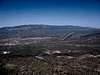
Popular Peaks of the Sheep Range

Hayford Peak Elevation 9,912 feet

Sheep Peak Elevation 9,750 feet
Overview
The Sheep Range is one of southern Nevada's major mountain ranges. Encompassing 636 sq. miles and running 56 miles from North to South with rewarding scenery. It streches from Highway 95 North of Las Vegas up through the Desert National Wildlife Refuge to just south of Alamo along Highway 93.The Desert National Wildlife Refuge manages this range. This is also the home to the largest habitat of desert bighorn sheep in the southwest. Other common wildlife include mountain lions, jack rabbits, diverse desert plants and much more. Joshua trees are common around 4000 feet. Above 6000 feet junipers and big sagebrush are common. Ponderosa pines and white fir dominate the landscape from 7000-9000 feet. Above 9000 feet bristlecone pines exist. The canyons within the Sheep Rage tend to be deep and rugged, many of them difficult to traverse with dry waterfalls.
The Sheep Range is very remote as well. Access to the range requires driving along Alamo Road. Depending on what canyon or summit you want to explore will determine which gravel road you will need to use. With this being very remote desert one should have the ten essentials with them. Be sure you have a good spare tire too. Let someone know if you are adventuring here alone as help could be a long time coming if something happens.

Some canyons in this range include Yellowjacket, Deadman, Wagon, and Joe May. There are many more. Exploration of this vast range is not very popular as the Spring Mountains attract many more tourists and locals in the Las Vegas area. What this range has to offer though can be very scenic and rewarding.
Getting There
From Las Vegas take HWY 95 north. When you get to Exit 93 set your odometer to zero.At 2.5 miles you will drive by the turnoff for Mt. Charleston. Keep going straight.
At 16.5 miles you will see the sign for Corn Creek Road. It is a brown sign on the east side of the highway near mile marker 101. Start slowing down and get ready to make a right turn.
At 16.7 miles turn right at the turn off for Corn Creek Road.
At 17.5 miles is the DNWR visitor center. Park here and sign the sign in sheet. This helps the DNWR get more money.
At 17.6 miles is the sign with all the roads. Make a left turn onto Alamo Road. The Sheep Range are now to your East (right).
 | | |  |  |
Red Tape/Camping
None. There are no concessions (i.e., no gas, lodging, food, campgrounds) on the Wildlife Rage. Camping is permitted anywhere within 100 feet of a designated road as long is it is not within 1/4 mile of a water source. Campfires are permitted using dead wood.However, there is no climbing allowed on the DNWR, ie Sheep Range.