
-
 29252 Hits
-
 95.35% Score
-
 52 Votes
|
|
Area/Range |
|---|---|
|
|
48.15303°N / 88.4693°W |
|
|
Hiking |
|
|
Summer |
|
|
1394 ft / 425 m |
|
|
Overview
Isle Royale National Park is one of the great backpacking parks in the lower 48. Interestingly, a survey in Backpacker magazine ranked it behind only Denali and Glacier national parks, and ahead of Rainier, as a backpacker’s park. This ranking is all the more remarkable because Isle Royale couldn’t be more different from these other parks. They have dramatic mountain scenery and a full suite of original wildlife. Isle Royale does not. Wolf Print
What makes Isle Royale such a remarkable destination? First, it’s remote -- you have to allow a day of boat travel to get there, in addition to however long it takes you to get to the northeastern tip of Minnesota (Grand Portage) or the northern tip of Michigan’s Upper Peninsula (Houghton or Copper Harbor). With its remoteness comes solitude.
Second, while it may not have the full suite of original wildlife Isle Royale does have famous wolves and moose. A scientific study of wolf-moose interactions helped train several generation of wolf researchers and yielded valuable information about predator-prey interactions, whether ecosystems are limited by food resources or predation, and a host of other topics. See the NPS science site for more information.
 Duncan Bay by hikeman76
Third, almost all of the island consists of federally-protected wilderness. The major exceptions are the NPS communities at Windigo, Rock Island, and Mott Island. There are a few other spots around the island that are not pristine, having seen primitive mines or logging operations. Several campgrounds on Lake Superior attract boaters in sufficient numbers to be managed as non-wilderness. Overall, though, the island gives you a remarkable sense of what the great North Woods must have been like 200 years ago.
Unlike, say, Mt. Washington, Isle Royale seems to attract a quality crowd. Everyone we met was an experienced backpacker. When I asked a ranger about the quality of the crowd, she commented, “we don’t see many new boots up here.” It’s nice knowing that if you do cross paths with another party, they won’t be doing something stupid.
Fun fact: Isle Royale gets about 14,000 backpackers a year, compared to about 16,000 in Yellowstone. However, total visitation in the two parks is totally different: 18,000 people to Isle Royale, three million to Yellowstone. You can also compare that number to the number of vehicles that enter Cades Cover in the Smokies each day in summer. Phrased differently, all the people who don’t leave their car in Yellowstone or the Smokies don’t even go to Isle Royale.
Topography and climate
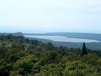 Feldtmann Lake from Feldtmann Ridge
The island is built around three primary ridges, the Minong, Greenstone, and Feldtmann (from northwest to southeast). The parallel ridges on Isle Royale continue on both sides of the island, where they are mostly under the surface of Lake Superior but occasionally pop up as islands. A similar line of ridges makes up the Porcupine mountains in Michigan’s Upper Peninsula, and some other locations around Lake Superior.
Because the glaciers retreated with all deliberate speed over most of the island, but lingered for a while on what is now the northwest shore, the beaches there are much more rugged, with steep slopes or cliffs down to the water’s edge in places. The slopes and beaches tend to be more gentle on the southeast side. The NPS has exploited this difference in geology in its trail design, making the Minong Trail more rugged and dramatic.
 Mount Ojibway by Indianabob
There’s enough elevation change that you can see several different kinds of forest. Sugar maple dominates a few of the higher spots, and mixes with yellow birch along much of the rest of the Greenstone Ridge. Yellow birch takes over along the hillsides of the southwestern half of the island, and spruce-fir, paper birch and aspen dominate the lowlands.
Though low in elevation, the island never really warms up. The average daily high in July and August is 69, and the record high is only 89. Expect at least light rain during any stay, and be prepared for windy weather blowing over the lake. Keep an eye for trees that might blow down on you when choosing a tent site.
Both Lake Superior and inland lakes are cold, and they have leeches (yuck). Come late in the season to avoid as many insects as possible.
Classic Hikes
Following the topography, the three major trails each follow a different ridge: the Minong, the Greenstone, and the Feldtmann. The first two are essentially week-long trips, while the Feldtmann is a weekend trip (2-3 nights). Lake Ritchie by dwhike
The Greenstone is the classic hike, going along the crest of the highest and longest ridge, the backbone of the island. It also takes the hiker up all the major “peaks” of the island, such as they are — the highest, Mount Desor, is 1394 feet tall. (The surface of Lake Superior is about 600 feet above sea level.)
The NPS designed the Minong as a more challenging hike, spending time on hard rock and demanding some route-finding skills. Both the Greenstone and the Minong can be hiked as “shuttles,” using the boat service (see below). The Greenstone endpoints are Rock Island and Windigo. You can hike the Minong from McCargoe Cove or start at Rock Island and spend a day on the Greenstone before cutting over to McCargoe Cove. Like the Greenstone, the Minong ends at Windigo.
Feldtmann gets the least traffic. It starts and ends at Windigo, at the southwest end of the island (nearest Minnesota). Because it traverses both the Feldtmann and Greenstone Ridges, it also includes more lowland hiking than the other two trails, connecting up through the Island Mine and Siskiwit Bay campgrounds.
 Chickenbone Lake by dwhike
On all these trips, you’ll find that your itinerary is moderately constrained. The NPS decided to manage usage by its campsite placement. Except on the Greenstone, campsites tend to be on Lake Superior, protecting the interior from overuse. Most campgrounds have pit toilets, a communal fire ring, and a few Adirondack-type shelters. Consistent with research on wilderness management, the NPS uses these amenities to reduce overall impact on the resource.
The layout means that you probably won’t be the only party in the campground. Whether that counts as “solitude” to you depends on your tastes.
It’s possible to hike and camp off-trail but the brush tends to be pretty thick, and I wouldn’t try to go far. Off the ridges, much of the island also tends to be pretty soggy and would make for uncomfortable cross-country travel. Some blank spots on the map are there for a reason, so if a ranger tries to dissuade you from a particular area, please respect that advice. There are good reasons, and they should not be posted on the web.
 Rock of Ages Lighthouse
My recommendation would be to keep cross-country travel up on the ridges or along the shorelines, and away from soggy bottomlands.
Reading Further
The essential guide is Jim Dufresne’s Foot Trails and Water Routes, which covers every trail on the island and most of the likely canoe/kayak routes. Be forewarned, though, that Dufresne tends to measure trail distances in odd ways. For example, he measures the Feldtmann Loop Trail from Windigo counterclockwise around to where the Loop meets the Greenstone Ridge Trail. That’s not a very useful measurement, as you’re still 5-6 miles away from the boat at Windigo. The explanation is that Dufresne describes trails and not itineraries. McCargo Cove by dwhike
 Moose Drool!
If you’re interested in natural history, the best book that I’ve seen is Napier Shelton’s Superior Wilderness. However, it’s useless for trails.
Getting There
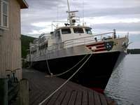
 The Voyageur II
You can get to Isle Royale from Minnesota or Michigan. Grand Portage MN lies between Duluth MN and Thunder Bay ON, and those count as the nearest cities. That trip is about 2-1/2 hours to Windigo, another three hours on to Rock Harbor. You can leave from either Copper Harbor or Houghton MI, depending on the schedule or the type of boat you like. Those docks are both pretty remote from most places in the US, but a day’s drive from cities such as Detroit (long day!), Milwaukee or Chicago.
From Grand Portage MN, you can take the Wenonah over and back on the same day (but why?), or take the Voyageur II over on Mondays, Wednesdays and Saturdays (returns Tuesdays, Thursdays, and Sundays). Both are managed by Grand Portage-Isle Royale Transportation Line.
From Michigan, the National Park Service runs the Ranger III out of Houghton. The journey takes six hours, and the NPS is experimenting with different schedules this summer, so call them directly. The Isle Royale Line runs the Isle Royale Queen IV out of Copper Harbor daily during the peak season. Its journey takes only three hours and it returns the same day. Both of these ships go to Rock Harbor only.
Finally, Royale Air Service operates on-demand service from Houghton County Airport to seaplane docks at Rock Harbor and Windigo.
 The Isle Royale Queen by dwhike
The boat services and the NPS keep track of who’s on the island, and they won’t let you get on a boat if you don’t have a reserved spot on a return boat. They will also notice if you don’t show up when scheduled to arrive. (I don't know what the NPS would do with that information, however.)
Permits and Fees
 Fireweed
When you arrive on the island, you have to fill out an itinerary and a permit. However, you don’t have to follow the itinerary. This gives you all the flexibility that you might want. When you depart, you have to correct the permit to reflect your actual itinerary. The National Park Service uses the data from the corrected itineraries for planning purposes.
The daily user fee is steep as such things go ($4/per person/per day), and is collected as part of your boat fare. However, the main expense is the boat fare, as well as the expense of getting to the boat dock in the first place. Instead of complaining, console yourself that this helps keep the riff-raff out.
Climber's Log
Because this is an Area/Range, you have to use the workaround for the Climber's Log, which is here. Thanks for visiting!News and Links
 Canvasbacks and Thimbleberries
News
Summer 2007: Water levels are so low in Lake Superior that the Wenonah can't make the run from Grand Portage to Windigo. This leaves the Voyageur II as the only option from Grand Portage.
Apparently some wolves have begun visiting campgrounds. There has long been a problem with people feeding foxes at Windigo and Rock Harbor, hopefully idiots won't start feeding wolves. The ranger orientation has been changed to ask visitors to provide negative reinforcement to any wolves they see, by clapping hands or otherwise startling the animal.
In August 2007, there were algal blooms on both Lake Ritchie and Chickenbone Lake. Such blooms can be toxic, even if the water is filtered, boiled or otherwise treated. Supposedly Lake Ritchie also smelled like raw sewage. If you're using the Greenstone Ridge (Chickenbone campsites) or Indian Portage trails (both lakes), check with rangers about current status.
 Moose Tracks
SP Forum Topics
There are three SP forums on Isle Royale. None receives much traffic, but YOU, gentle reader, can change that:
Hiking Isle Royale?
Isle Royale NP
Suggestions for Isle Royale
Links
NPS Isle Royale site.
Isle Royale Natural History Association is the volunteer organization that supports the Park Service in Isle Royale. They also have books, videos and other products available on their website.
Discussion forum on Isle Royale.
John Vucetich of Michigan Tech currently leads the wolf-moose study, which has its own site here. It's possible to volunteer on the study through Earthwatch, which will set you back 9 days and about $1000. If you've done this, I'd love to hear about it.