
|
|
Area/Range |
|---|---|
|
|
46.53300°N / 86.488°W |
|
|
Hiking |
|
|
Spring, Summer, Fall, Winter |
|
|
1020 ft / 311 m |
|
|
Welcome to the Lakeshore!
 Pictured Rocks National Lakeshore is one of my most treasured hiking destinations. Within the state of Michigan, Isle Royale alone compares. Pictured Rocks encompasses around 33,500 acres of Lake Superior shoreline along with another 38,000 acres inland as a separate, state run, protective “buffer zone.” The park stretches along the Lake Superior shore some 45 miles from Munising to Grand Marais in Michigan’s Upper Peninsula. The park hugs the shore very closely, for much of its length reaches barely a mile inland. At its center it is at its widest where it bulges southward, following the escarpment 3 miles inland around the Beaver Lake basin.
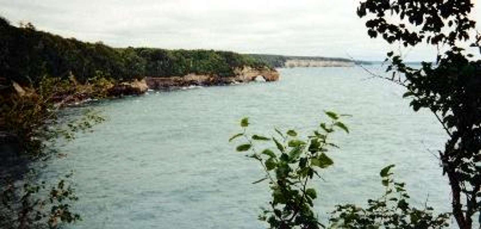
The Lakeshore can be divided into three distinct regions, each occupying about a third of the parks shoreline. The first and most dramatic region is to the south. This region includes the famous cliffs of Pictured Rocks and stretches for 13 miles from Munising Bay up to Twelvemile Beach. Over the eons successive layers of sandstone were layed down atop one another. The lower, Jacobson (or Chapel Rock) formation, extends only a few feet above the waters of Lake Superior and is the hardest of the three layers. Above this, composing the majority of the visible cliff-face are the many softer layers comprising the Miners Castle formation. This layer is the most susceptible to erosion of the three and accounts for the distinct concave slope of the cliffs. Atop all this is the hard sandstone crust of the AuTrain formation. This formation is responsible for the many scenic, but potentially hazardous, overhanging cliffs along the lakeshore.
The cliffs grow increasingly high and steep as you journey north from Munising Bay until they culminate in the giant prominence of Grand Portal Point which rises nearly 200 feet directly out of the waters of Lake Superior. To the north the cliffs lower slightly to “only” around 100’ before eventually turning inland at Twelvemile Beach.
Twelvemile Beach is the second major region of Pictured Rocks. Actually around 14 miles in length, Twelvemile is one of the most spectacularly untouched beaches in the state of Michigan. Only a handful of backcountry campsites line its shore along with two somewhat unknown State Forest campgrounds at its north end. Hikers standing at the midpoint of Twelvemile beach could easily imagine themselves the only ones in the park as they look to the north and south along the empty, unending stretch of sand.
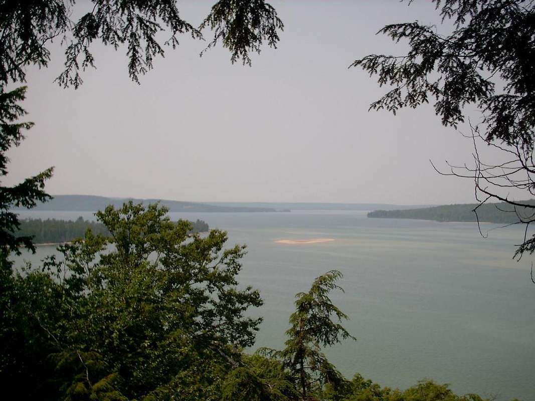
Occupying the northern third of the Lakeshore is another striking landform. This would be the enormous Grand Sable Banks. From a distance they appear as gigantic sand dunes rising from the lake at impossibly steep angles. Referring to them as “dunes” is only partly true. In fact the Grand Sable Banks are comprised of two distinct geological features. Rising directly some 275’ from the lake are thick deposits of glacial debris left when the last of the glaciers retreated north some 10,000 years ago. The gravel that comprises the banks can remain stable at much steeper angles than traditional sand dunes thus giving the banks their dramatic grade. Atop the banks, rising another 100’ are the Grand Sable Dunes. Referred to as “perched” dunes as they sit high above the lakeshore, the dunes are wonderfully barren, covered by grasses and stands of Jackpine.
Pictured Rocks National Lakeshore includes 60 or so miles of some of the most beautiful lakeshore hiking anywhere in the Great Lakes Region. In addition, the Lakeshore has become increasingly popular as an ice climbing destination during the winter months. Downwind Sports, a local outfitter, will be hosting its 25th annual Ice Fest here in 2008. Pictured Rocks is a special place for me and I would like to be the first to welcome you to this amazing area. Please enjoy looking around!
A New Kind of Park...
 The first white men probably passed through this region in the early 1600’s. The land was inhabited by the local Chippewa Indians and was highly valued in early years for its rich supply of furs. The fur trade reached its peak in the early 1800’s and soon thereafter, in 1855, the Chippewa’s signed away rights to the area. By the late 1800’s the logging industry was hitting its stride and huge swaths of lakeshore woodlands were felled and shipped south. The most tragic event occurred in 1885 when the Kingston Plains, just inland of Twelvemile Beach, were clear-cut and subsequently swept by an enormous forest fire. For years the land was completely bare and even to this day when you drive through the Kingston Plains area the landscape still “feels” abused.
As the 20th Century dawned wealthy business owners from Munising and as far away as Chicago were beginning to set up summer residence along this beautiful stretch of shoreline. Pictured Rocks began to be an increasingly popular tourist stop. In 1958 the federal government did a study of some 5,500 miles of Great Lakes shoreline and singled out the stretch of shoreline from Munising to Grand Marais for inclusion in the National Park system “by virtue of the unique and spectacular scenery…unmatched elsewhere in the Great Lakes." Thus, on October 6, 1972, Pictured Rocks entered the park system as the nations very first National Lakeshore.
Concerning the Critters...
 Many of the species that once drew fur trappers to this area still exist within the park. Beaver are most abundant but fishers, mink, martens, skunks, fox, wolves, and deer also roam the woods and wetlands. Moose are also said to be occasionally seen although very rarely. I’ve visited the Lakeshore dozens of times and haven’t seen so much as one Moose track. Bear are of most concern to hikers within the park though they pretty much keep to themselves unless you leave a nice treat sitting out for them. All backcountry sites come equipped with bear poles and I’d highly recommend using them.
The most troublesome creatures in the park are the smallest. As with all North Woods locations the Pictured Rocks area has a definite “bug season.” This usually lasts from late May into July depending on how wet the summer is. Mosquitos, Black Flies, & No-See-Ums can all conspire to make even a short walk along the shore a taxing experience. The most diabolical insect I’ve come across is the Stable Fly. This tiny terror looks like a common house fly but instead of a harmless little pad for a tongue this fly has a dagger. They attack in ungodly swarms, are impervious to Deet, and have the ability to bite through two layers of clothing. Stable flies tend to have a greater presence during periods of warm stagnant weather and they tend to hug the lakeshore so your best bet is to explore the parks more inland attractions when they are present.
Getting There & Access Points...
The two small towns of Munising and Grand Marais mark the west and east entry points to the Lakeshore. Munising is the more developed of the two towns and is home to the Pictured Rocks/Hiawatha National Forest Information Center. This is where you’ll have to go to get backcountry permits (explained later) and is generally your best bet for obtaining information on the Lakeshore. The Information Center is open year-round Monday-Saturday from 9am-4pm. 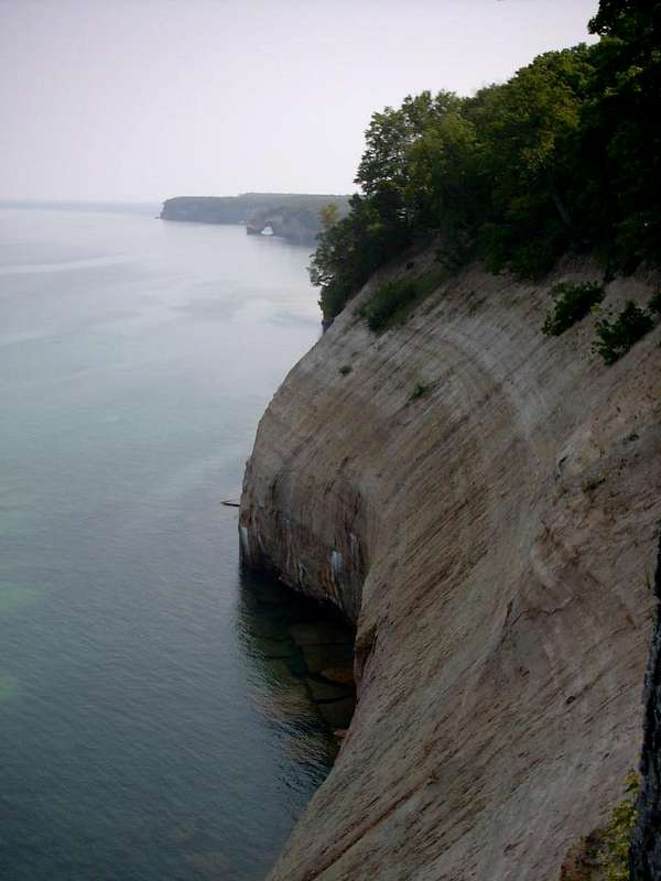 Munising
You’ll probably arrive in Munising from one of three directions; from the east (Lower Michigan), west (Duluth, MN), or south (Green Bay, WI).
- From the east (Lower Michigan): After crossing the Mackinac Bridge take US-2 west for 42 scenic miles along the Lake Michigan shore to M-117 and turn right. Take M-117 north for 14 miles until it ends at M-28. Take a left (west) and keep on M-28 for 55 miles until you drop to the Lake Superior shore at Munising. At the first and only light you’ll come to take a right and you’ll see the Info Center on your right.
- From the west (Duluth): Simply follow US-2 east through Wisconsin and into Michigan. Eleven miles into Michigan, at Wakefield, make a left onto M-28 and continue east 186 miles to the stoplight in downtown Munising. Go straight through the light at the Info Center will be on the right.
- From the South (Green Bay): Take US-41 north towards Michigan. Shortly after crossing the border, in Menominee, bear right onto M-35 which will take you north to Escanaba. In Escanaba you’ll want to merge onto US-2 heading east. Follow US-2 for about 30 miles through Escanaba and Rapid River to Forest Road H-13 on you’re left; it may be tricky to spot. Despite bring a forest road, H-13 is wide and paved. It tracks 35 beautiful miles through Hiawatha National Forest to M-28 just east of Munising. Turn left and in a few miles you’ll be at the light in Munising with the Info Center on your right.
Grand Marais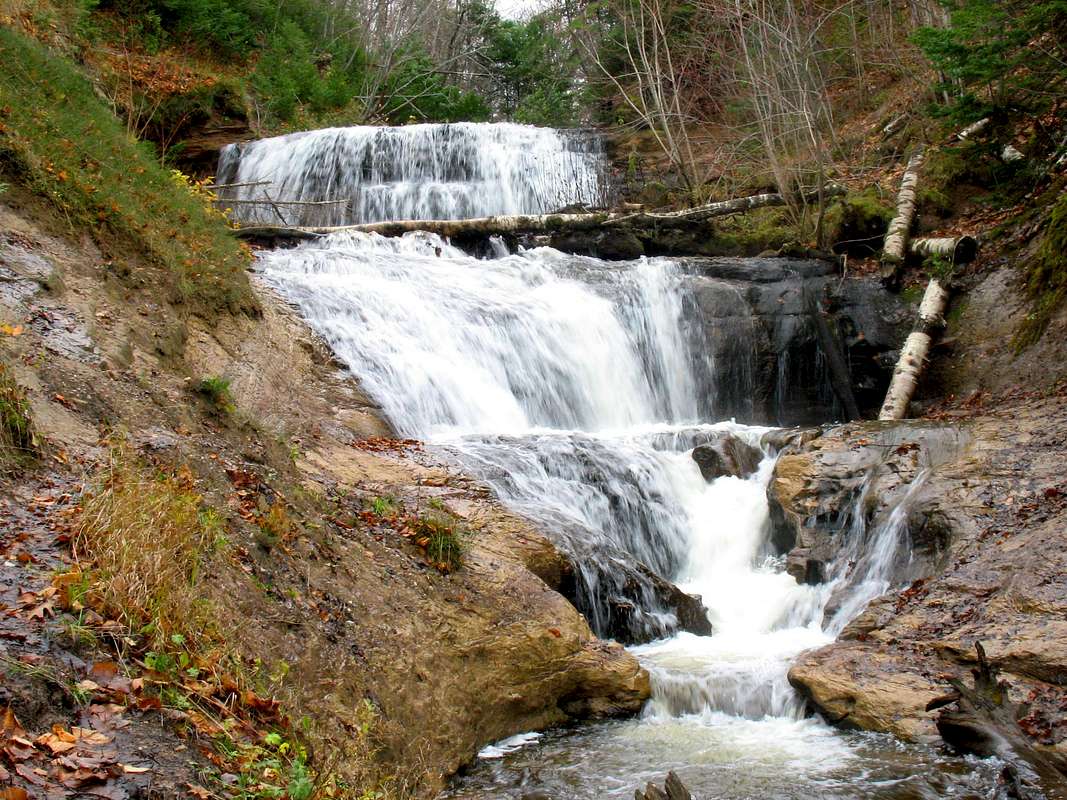 Grand Marais is a pretty little town on a pretty little harbor at the east end of the park. You can get from Munising to Grand Marias by two routes depending on the season. The best route to take follows M-28 east out of Munising for 35 miles to the crossroads town of Seney. From Seney you’ll head north on M-77 another 25 miles to Grand Marais. Signs in town will point you to the Lakeshore. It’s a seasonal town. The Grand Sable Visitors Center west of town is only open during the summer months. During the winter the community caters to huge numbers of snowmobilers. Thankfully, the backcountry of the park is unsuitable and off-limits to snowmobiles.
The other route you can take is H-58 which follows eastern boundary of the park for 48.1 scenic miles north to Grand Marais. The road provides the only access to the backcountry areas of the Lakeshore. However, H-58 is not plowed in the winter so if there’s snow on the ground when you visit don’t plan on using it. Also, visitors to Pictured Rocks in the past may have fond memories of bouncing along this sandy two track. No more! In 2010 Michigan completed paving of the entire route. This will certainly ease access to the backcountry which gives me mixed feelings but will certainly take some stress off your vehicle when you visit!
Backcountry Access
As mentioned above access to the backcountry is only available off H-58. There are a number of roads off H-58 that provide summer-time access to the interior of the park. The several access points you can reach are as follows from west to east (or south to north if you prefer)...
Distances are from the Munising Information Center...
- Miners Castle Road (H-11): 4.1 miles; Heads north 5 miles to Miners Castle and Miners Beach areas giving access to the Lakeshore Trail just west of Potato Patch Backcountry Campground.
- Chapel Road (County Rd. 695): 12.2 miles; Heads north 6 miles to the Chapel Parking Area. The Mosquito Falls and Chapel Basin Trails begin hereHeading in opposite directions to different points of the Lakeshore Trail and some of the highest cliffs in the park. Combined with the Lakeshore Trail these trails can combine for one of the most spectacular day-hikes in Michigan!
- Little Beaver Road (County Rd. 699): 17.3 miles; Heads north 3 miles to Little Beaver Drive-in Campground. From here you can follow the White Pine Trail inland around Beaver Lake or follow the Beaver Creek Trail out to the Lakeshore Trail on Twelvemile Beach.
- Twelvemile Beach Campground: 34.0 miles; A 37-site Drive-in Campground situated along the Lakeshore Trail near the east end of Twelvemile Beach. Benchmark Backcountry Campsite is just north along the trail.
- Hurricane River Campground: 36.4 miles; A 21-site Drive-in Campground situated along the Lakeshore Trail at the east end of Twelvemile Beach.
- Log Slide Overlook (County Rd. 724): 42.1 miles; A short road leads out to the stunning Log Slide Overlook that gives a birds-eye view of AuSable Point to the west and the towering Grand Sable Banks to the east. The Lakeshore Trail passes the overlook.
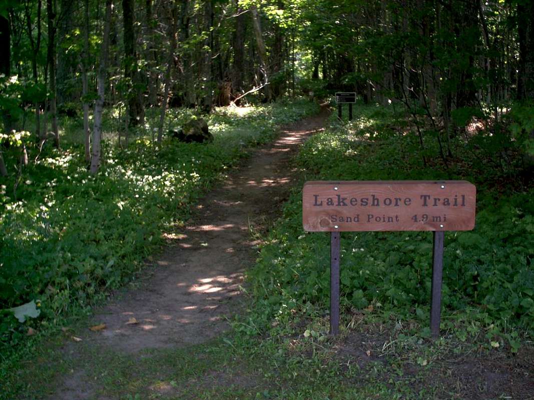
The Lakeshore Trail
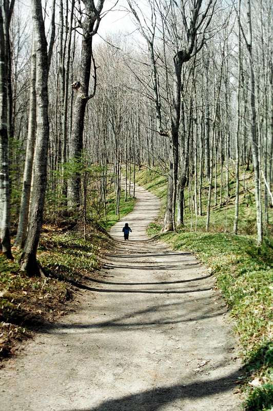
 There are over 60 miles of hiking trails within Pictured Rocks National Lakeshore. For the most part the trails are well-marked and easy to follow. Grades are generally easy although at times they can be steep, particularly when you ascend or descend the escarpment. In the southern third of the park the trails tend to be covered with dirt or rock while the trails along and north of the cliffs tend to be sandier.
The Lakeshore Trail is the crown jewel of the Pictured Rocks Trail system. The Lakeshore Trail runs 42.4 stunning miles from Munising Falls in the south to the Grand Sable Visitors Center in the north. Rarely, over its entire length, do you ever loose sight of the shore. The trail is wonderfully diverse, passing cliff-top vistas, endless beaches, high dunes, and waterfalls. The Lakeshore Trail makes for one of the premier backpacking trails in the Great Lakes region. Here's a brief description from south to north...
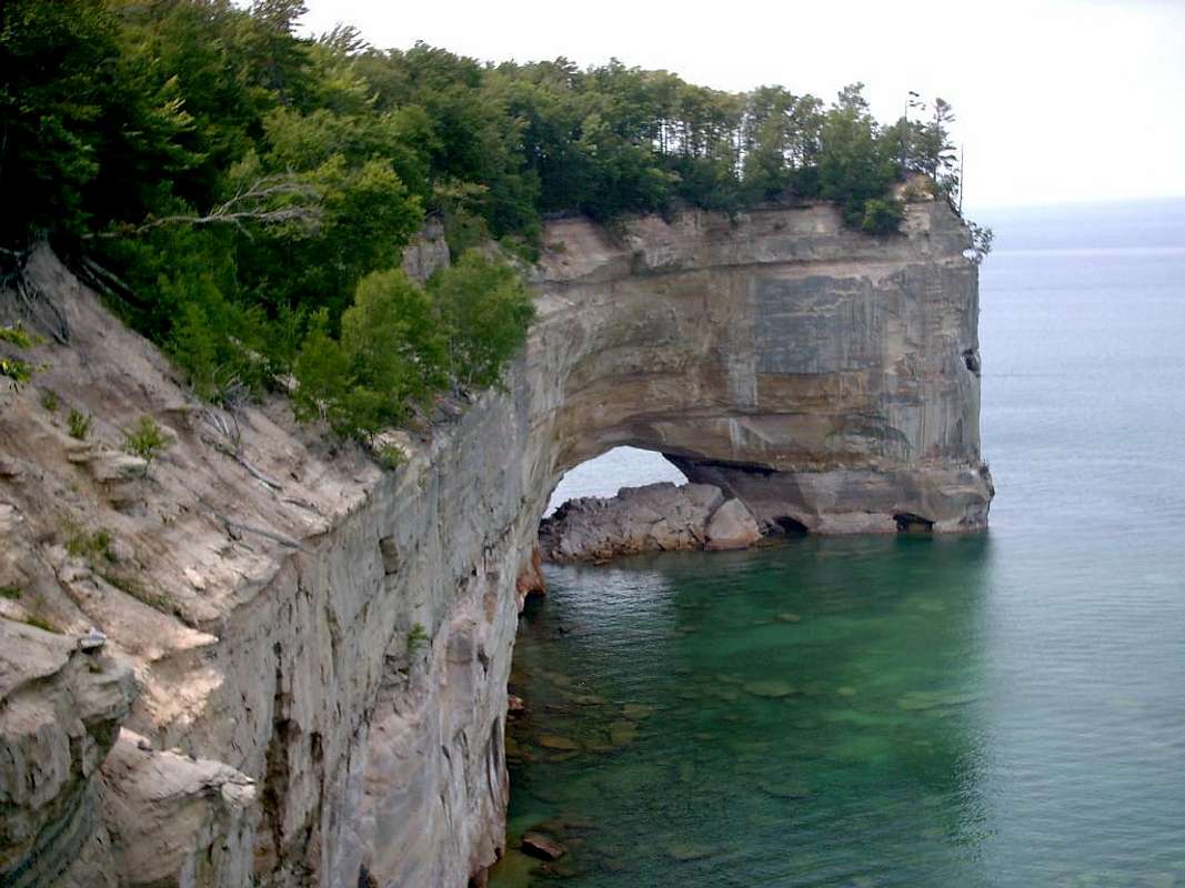
- The Lakeshore Trail begins at Munising Falls and makes its way north past old fields, through thick forests, and past a handful of unnamed cascades. After the first few miles you begin following the cliffs high above Lake Superior. The cliffs are thickly wooded and not as steep along this stretch though so views are limited. About 9 miles in you will break out into the hustle and bustle of the Miners Castle area. Miners Castle is a beautiful and famous rock formation that is one of the parks biggest attractions. Recently, in 2006, one of the “stacks” atop Miners Castle crumbled and fell into Lake Superior, a sign that these cliffs are undergoing constant change. The views here are nice but no doubt the crowds will cause you to head for the woods again before long.
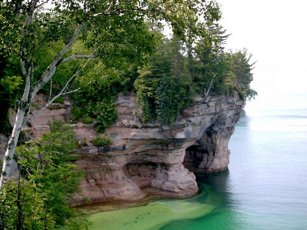
- As you continue north the cliffs grow increasingly high and steep. This section of trail is regarded as the most scenic in the park. You will pass by famous formations such as Arch Rock and Indian Head Point before arriving at Grand Portal Point, the highest of the cliffs at around 200’. The trail along this stretch can be rocky and sometimes steep. Blow-downs can be a real issue along this part of trail as well. You’ll descend briefly to Chapel Beach and pass by the famous Chapel Rock with its giant pine. The trail from the Chapel area north follows the cliff-top but you rarely see the edge due to the thick foliage. About 2 miles north of Chapel watch for an outlook that looks back south and you might be able to see the beautiful Spray Falls which leaps from the cliffs 70’ directly into Lake Superior. In another 2 miles the escarpment turns inland at Coves Campground and you’ll begin your long walk along Twelvemile Beach.
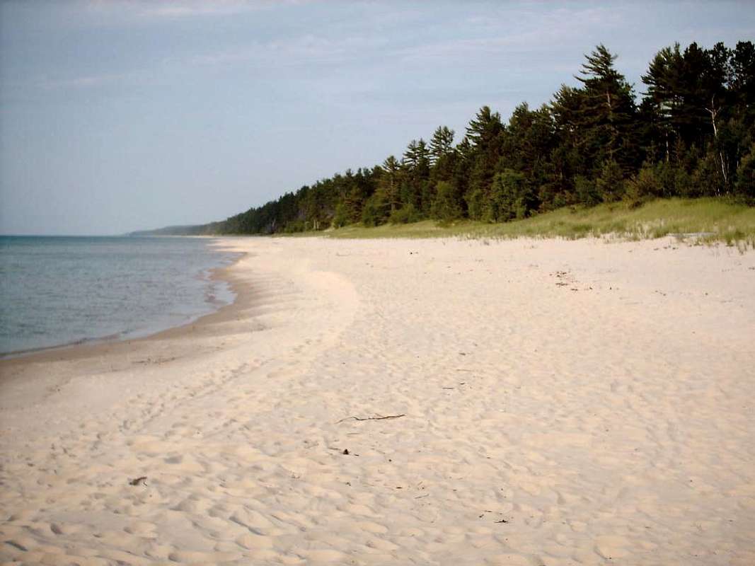
- For much of its run up Twelvemile Beach the trail stays within the shelter of the trees and occasionally even far enough to loose sight of the lake. I’ve found a nice option for this section is to just walk the beach. You can catch the cooling breeze of Lake Superior and avoid the insects that populate the forest. Don’t worry about loosing your way, occasionally you’ll be forced to cross a couple of streams (Beaver Creek, Sevenmile Creek) at which point you can easily wander upstream to find the Lakeshore Trail again. Ten miles from where you started your beach walk the trail passes through Twelvemile Beach Drive-in Campground, crosses H-58 a couple times, and then passes through another drive-in campground at Hurricane River. There’s a nice picnic area here that makes for a wonderful place to stop and rest your feet.
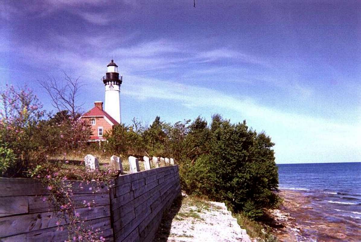
- Following the shore ever northward the Lakeshore Trail leaves the campground and follows the access road for the Au Sable Lighthouse 1.2 miles ahead. Just after you leave the campground you’ll see a couple of signs pointing you down to the beach where you can see the remains of old shipwrecks along the beach. The lighthouse at Au Sable Point was built in 1874 and stands over 100’ tall. During the summer months a ranger makes his way out to the light and provides tours of the light on a first-come-first-served basis. There is a small fee ($3) which is more than worth what you’ll get to see. The view from the top is stunning. To the south and west the distant cliffs of Pictured Rocks are visible along with Grand Island while to the east are the enormous Grand Sable Banks, rising over 300’ directly out of the lake.
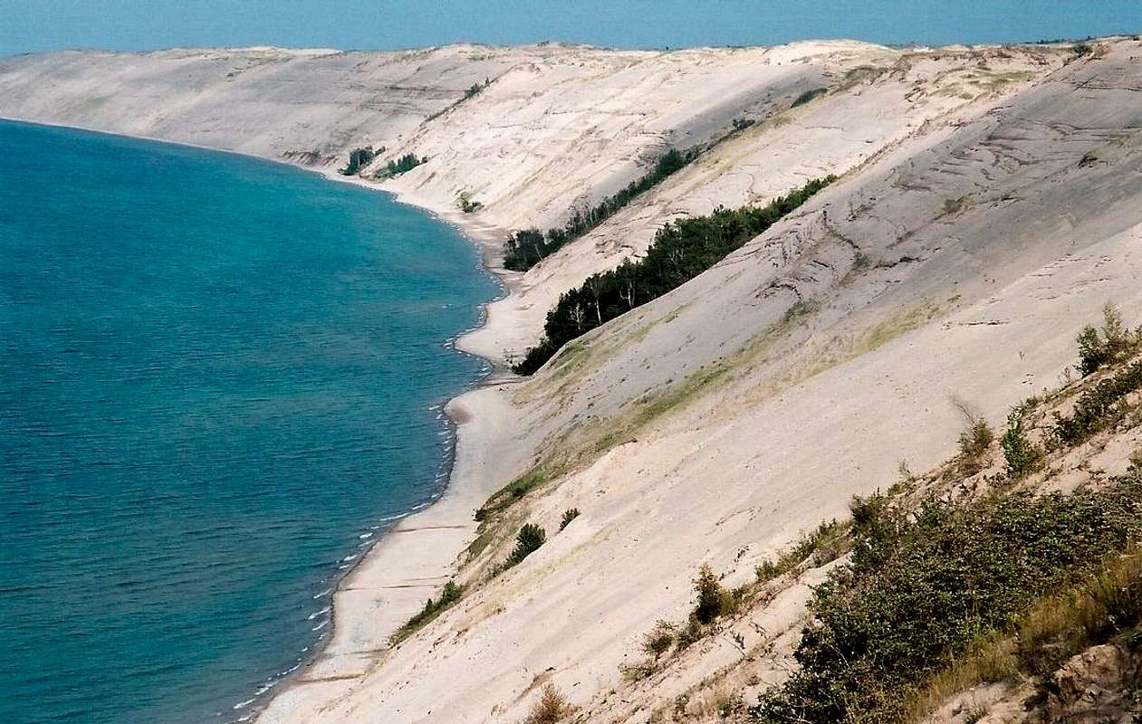
- Leaving the lighthouse you will make the long climb up to the Log Slide area where there are more excellent views of the dunes (you’re now on top of them). From the Log Slide the trail heads away from Lake Superior around the southern edge of the Grand Sable Dunes. The trail crosses H-58 for a brief visit to Grand Sable Lake where there is another nice picnic area. From here the trail uses H-58 to squeeze between the dunes and the lake before heading south of the road again for the final half mile to it end at the Grand Sable Visitors Center.
Other Trails...
| Trail | Trailhead | Length | Description |
| Beaver Creek | Little Beaver Lake Campground | 1.5 miles | Runs along the west shore of Beaver Lake to the Lakeshore Trail near Beaver Creek Backcountry camp. |
| Chapel Basin | Chapel Road Parking Area | 3.0 miles | Connects the Chapel Parking Area with Chapel Beach near Chapel Rock. Passes the 100' Chapel Falls along the way. Can be combined with the Lakeshore and Chapel Basin Trails to make a spectacular 10-mile loop. |
| Fox River Pathway | Lakeshore Trail north of Sevenmile Creek | 27.0 miles | Only the first mile of this trail lies within the National Lakeshore. It continues south through the wild Lake Superior State Forest to Seney. |
| Grand Sable Dunes | Sable Falls Parking Area | 1.0 miles | A short somewhat steep hike out onto the GRand Sable Dunes. |
| Miners Falls | Off Miners Castle Road | 1.2 miles | The trail follows the escarpment out to 70' Miners Falls which sits in a deep gorge. Snow can linger behind the falls until July! |
| Mosquito Falls | Little Beaver Campground | 2.5 miles | A connector to the Lakeshore Trail, it passes the small (10') but pretty Mosquito Falls about halfway out. Can be combined with the Lakeshore and Chapel Basin Trails to make a spectacular 10-mile loop. |
| Munising Falls | Munising Falls Parking Area | 0.25 miles | Located alongside the trailhead to the Lakeshore Trail this is the busiest trail into the park leading to its busiest attraction, 70' Munising Falls. Once, not long ago, you could walk behind the falls. No more thanks to liability issues. |
| Sable Falls | H-58 just west of Grand Marais | 0.6 miles | A pretty little hike out to Sable Falls. The falls sit in a narrow gorge and are very powerful for their size. |
| Sand Point | Sand Point Beach | 1.0 miles | A connector to the Lakeshore Trail, it heads up from Sand Point through marshlands eventually meeting the Lakeshore atop the escarpment. A bit steep in spots. |
| White Pine Trail | Little Beaver Campground | 3.5 miles | The first 0.7 miles of this trail are interpretive but you can continue on it along the east shore of Beaver Lake to the Beaver Lake backcountry sites and eventually the Lakeshore Trail at Trappers Lake. |
Camping...
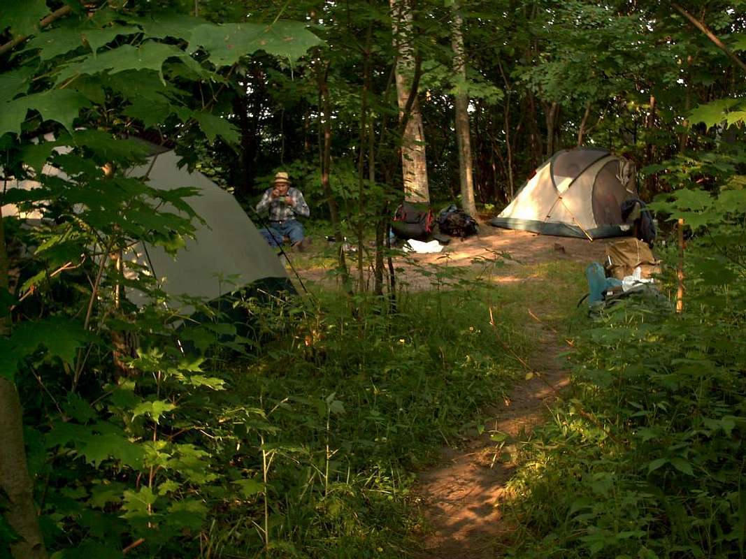 Most of the backcountry campsites in Pictured Rocks sit along the Lakeshore Trail at 3-5 mile increments. They are your only option for camping in the backcountry and reservations are a must. The Lakeshore starts accepting reservations for the upcoming year on January 1st. There is a $15 reservation fee.
All campsites, both backcountry and drive-in, are by reservation only. All reservation are made through recreation.gov. The park staff cannot process any fees regarding camping at the visitor centers, it must all be done online. The drive-in campgrounds have increased in price to $20 a night.
Some front-country areas of the park have been opened to dogs (such as the trail to Sable Falls, the trail to Au Sable Light Station, and the trail to Miner's Falls) but dogs are still not allowed in the backcountry, on the North Country Trail, or in any of the backcountry campsites.
The following are the backcountry sites located along the Lakeshore Trail from south to north. I noted mileposts but don’t expect to find neat mile markers in the backcountry. I included them just to give you an idea of where they were located along the trail and in relation to each other…
| Campground | Milepost | Water Access |
Toilets | Fires Allowed? |
Description |
| Cliffs | 5.1 | None | No | Yes | Located along a remote section of the Lakeshore Trail midway between Sand Point and Miners Castle. The sites sit in a hardwood forest high above the lake, pack your water in. |
| Cliffs Group | 6.4 | None | No | Yes | Located a little over a mile north of Cliffs campsite between Sand Point and Miners Castle. The sites sit in a hardwood forest high above the lake, pack your water in. |
| Potato Patch | 8.9 | Lake | No | Yes | Campsites sit in a large field just north of Miners Beach. Water is available from Lake Superior but it is a steep climb down to the water to get it, plan on having to work to get your water or stock up before you climb the escarpment. |
| Mosquito River | 12.0 | River | Yes | No | A nice campsite nestled among the pines. Don't be concerned about its name, you're no more likely to deal with biting insects here than anywhere else in the park. |
| Chapel Beach | 16.4 | Lake | Yes | No | Perhaps the busiest backcountry site in the park, for good reason. The campground sits just inland from Chapel Beach which is nestled among some of the highest cliffs in the park. |
| Coves Group | 19.2 | None | No | Yes | Kind of a lousy spot for a campsite. It sits in a beautiful hardwood forest atop high cliffs but the closest water is 1.5 miles north at Coves Campground where the cliffs end. |
| Coves | 20.7 | Lake | No | Yes | Located at the southern end of Twelvemile Beach. A beautiful campsite I've used many times. Laying out on the beach after a long day on the trail is great! Road access can be found 2 miles inland at Little Beaver Lake Campground. |
| Beaver Creek | 22.0 | Lake | No | Yes | Located at the mouth of Beaver Creek just inland from the big lake. Road access is 3.2 miles inland along the Beaver Creek Trail to the Little Beaver Lake Campground. |
| Pine Bluff | 23.5 | Lake | No | Yes | The name of this site says it all. The campground sits on a high sandy bluff above Twelvemile Beach in a stand of large pines. An alternate stop could be at Trappers Lake Backcountry camp which is located just a half mile inland. |
| Sevenmile Creek | 28.0 | River | No | Yes | You want solitude? This campsite has it. Located about midway along Twelvemile Beach about 3 miles south of Twelvemile Beach Drive-in Campground, you're guaranteed your own private piece of beachfront property here! |
| Benchmark | 31.2 | Lake | No | Yes | This campsite is located just 0.3 miles north of Twelvemile Beach Drive-in Campground. Though no toilets are located at Benchmark you can treat yourself by taking the quick walk back to Twelvemile. |
| Au Sable East | 35.3 | Lake | No | Yes | Au Sable East is wedged tightly along the rocky lakeshore among a thick grove of Cedars. Just west along the Lakeshore Trail is the Au Sable Lighthouse which is open for tours in the summer. Road access is located just under 2 (steep) miles north at the Log Slide. |
| Masse Homestead | 38.3 | None | No | Yes | No water is available at this lightly used campsite tucked up against the Grand Sable Dunes. The campsite is located 4 miles south of the Lakeshore Trail's north terminus at the Grand Sable Visitor Center. |
In addition to the campsites along the Lakeshore Trail there are two campgrounds inland from the lake, the same rules apply to these as to those above…
| Campground | Water Access |
Toilets | Fires Allowed? |
Description |
| Beaver Lake | Lake | No | Yes | Sits on the south shore of Beaver Lake 2 miles from Little Beaver Lake Drive-in Campground. Not easily accessed from the Lakeshore Trail, this campground is more for people who want a quiet overnight without cars driving by. |
| Trappers Lake | Lake | No | Yes | Trappers Lake is located only a half mile inland from Twelvemile Beach from Pine Bluff Campground. This campground is a nice option to consider if the bugs are bad along the lakeshore. |
There are also three drive-in campgrounds operated by the Park Service in Pictured Rocks. All have vault toilets and drinking water available. Weather-permitting the campgrounds are open from May 10 to October 31.
| Campground | Cost ('07) | Access | Description |
| Little Beaver Lake | $12 | 3 miles north of H-58 on Little Beaver Road (County Rd. 699) | A tiny 8-site campground on Little Beaver Lake. Provides access to the Lakeshore Trail 1.5 miles away near Coves Campground. Drinking Water, toilets, and a boat launch are available. |
| Twelvemile Beach | $12 | Located along H-58; 34 miles from Munising and 15 miles from Grand Marais. | This campgrounds 36 sites sit atop a high sandy bluff overlooking Lake Superior. Facilities include a picnic area, toilets, and drinking water. |
| Hurricane River | $12 | Located along H-58; 36 miles from Munising and 12 miles from Grand Marais. | Hurricane River has 21 sites separated into two loops. Nearby the Hurricane River empties into Lake Superior next to a nice picnic area. Toilets and drinking water are available. The lighthouse at Au Sable Point is a little over a mile up the shore. |
Ice Climbing...
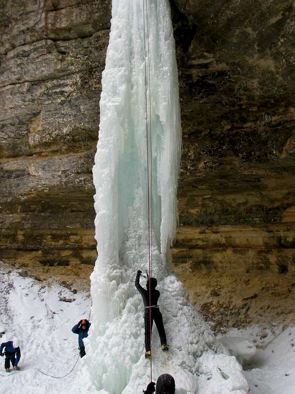 For the last 24 years Pictured Rocks has been home to the Michigan Ice Fest. Every year in February the local outfitter Downwind Sports, along with local merchants, present this unique opportunity to ice climb Pictured Rocks. The majority of the climbs are located along the escarpment between Munising Falls and Sand Point. The 2007 Ice Fest Itinerary is available for viewing. According to the 2007 brochure there are something like two dozen climbs available and plans are being made to allow climbers farther into the backcountry. The dates for the Ice Fest this coming year are February 1-3, 2008. If you’d like more info I’d encourage you to click the following link or call one of the numbers below...

***I must explain that I do not ice climb. I don’t have any idea about the nature of the various routes or their difficulty (climbing a frozen 70-foot waterfall looks plenty hard to me!). If anyone has additional technical or non-technical information I beg you to contact me so I can include that information here. Thanks!***
Red Tape...
 There are no entrance fees to Pictured Rocks National Lakeshore, if you’re just visiting for the day it won’t cost you a penny. If you intend to visit the backcountry there is a $15 reservation fee payable in advance as well as a $4/day user fee payable when you arrive.
-No pets are allowed on the parks trails or beaches so please leave Rover at home…
Also, as stated elsewhere there is very limited access to the backcountry during the winter months. Between November and May over 200” of snow falls on the park and most roads are unplowed. The Lakeshore Trail is only accessible at from Munising Falls or the Grand Sable Visitors Center at the other end. Keep in mind that help can be A LONG way away if you get yourself into trouble so be prepared. Oh, and don’t bother to bring your cell phone, it won’t work.
Useful Links...
 Pictured Rocks National Lakeshore - Official Page
Pictured Rocks Park Map - from the NPS
Pictured Rocks Guidebook - THE book to have for hiking the Lakeshore
Munising Weather - National Weather Service
Upper Peninsula Snowdepth Map - from JohnDee.com
DWhike's Adventures - Shameless self promotion...come visit my website for more pics of Pictured Rocks NL and other places that I have wandered off to in recent years...
