
-
 89845 Hits
-
 97.08% Score
-
 65 Votes
|
|
Area/Range |
|---|---|
|
|
45.15212°N / 114.59098°W |
|
|
Hiking, Mountaineering, Scrambling |
|
|
Summer |
|
|
 Bighorn Crags
Overview
The Bighorn Crags are a sub-range of central Idaho’s Salmon River Mountains and are comprised of a fantastic grouping of granite peaks and alpine lakes. They are also the crown jewel of the vast 2.4 million acre Frank Church – River of No Return Wilderness. The wilderness is the largest such area in the continental United States. Of the 2500 miles of trail in the wilderness area, the most traveled ones are found in the Bighorn Crags. The area is popular by Idaho standards, but the crowds are generally still considered small when compared to other areas containing this much beauty. Probably the biggest factor that keeps the masses away is the long drive required to reach this remote area (see “getting there”).
 Fishfin Ridge, photo by pioneerclimber.
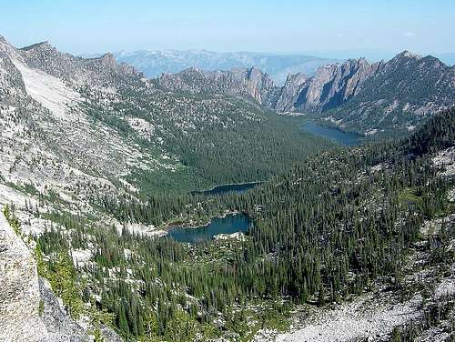
With rugged granite rising up everywhere, and crystal clear alpine lakes galore, the Bighorn Crags are a must see for Idaho backpackers. The rock comes in all shapes and sizes. Big and small, jagged and domed. The craggy granite is all over the place. The best-known collection makes up a crest known as Fishfin Ridge, where some of the more noteworthy spires and monoliths are located. The ridge could be reached in a day of hiking, but it would be a waste to make the long drive without exploring other parts of this beautiful area. Spending time in then northern portion of the range gives you the best chances of running into a herd of the Bighorn Sheep, which the area is named for.
In addition to Fishfin Ridge, another must see attraction in the range is Ship Island Lake. This is the largest lake in the Bighorn Crags, measuring over 1.2 miles long. To most, the rock island out in the middle doesn’t bear much resemblance to a ship, but the lake is surrounded by tall peaks, and highlighted by huge cliffs known as the Litner Group (Lopez pg 123) located beyond the outlet of the lake.
Peaks
 Knuckle Peak, photo by pioneerclimber.
|
|||||||||||||||||||||||||||||||||||||||||||||||||||||||||||||||||||||||||||||||||||||||||||||||||||||||||||||||||||||||||||||||||||||||||||||||||||||||||||||

Heart Peak
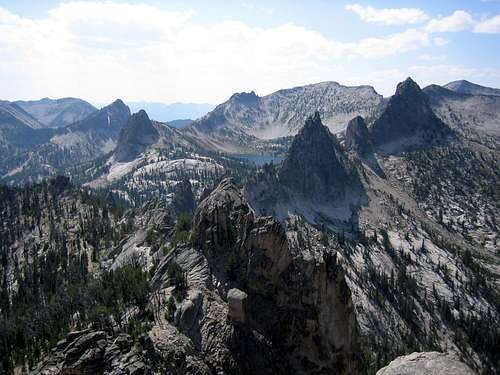
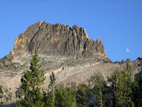
The Bighorn Crags offer climbing opportunities for all skill levels. The area contains easy hikes to rounded hilltops, challenging scrambles along jagged ridges, and technical climbing on the various granite features. Peakbaggers who come to the area will make a point to visit Mount McGuire, which stands as the highest elevation in all of the Frank Church Wilderness at 10082’. Technical climbers tend towards Fishfin Ridge features such as Knuckle Peak and the Rusty Nail, or can venture deeper in the area to size up the Litner Group with its plethora of unclimbed routes. Most of the visitors to the area come to enjoy backpacking or trout fishing, so mountaintops offer almost guaranteed solitude.
Early climbers of note include the legendary USGS surveyor Thomas M. Bannon, who posted several first ascents while sizing up the area back in 1912. Mount McGuire was one of these ascents along with many other highpoints. Technical climbers came later, and some of the earliest visitors of that kind were Lincoln Hale and Pete Schoening who put up several routes and first ascents in the summer of 1955. Their highlight was a climb of Knuckle Peak, the grandest climbing prize of the area. (Schoneing is best known for “The Belay” on K2 in 1953 as well the first ascent of Gasherbrum I in 1958.) Word got out about the area after Hale published a brief article about their visit, and the newly formed Idaho Alpine Club established many other routes shortly after that. Early members included Bill Echo, Dean Milsap, and Bob Hammer (Lopez pg. 20).

Aggipah Mountain
In all, there are about 37 peaks in the Bighorn Crags that either meet the 300’ clean prominence rule, are officially named, or both. Of the 37, only ten carry official names recognized by the USGS Board on Geographic Names. The number is unlikely to grow since it is very uncommon for new “official names” to be designated within a wilderness area.
Where to Camp
After the long drive in to reach the area, most will take advantage of trailhead camping at Crags Campground or head further down the road a few miles to Yellowjacket Lake, which is generally less crowded and a bit more scenic. Those who do hit the trail on the same day as their arrival may chose to make camp at Cathedral Lake, which is just over 4 miles in from Crags Campground.
With an abundance of trout filled lakes in the area, most backpackers choose to set-up camp by the lakeside with rugged peaks rising up around them. The most popular campsites are at the previously mentioned Ship Island Lake, just under 11 trail miles from Crags Campground. Wilson and Harbor Lakes are also very popular. These are located just off the main trail near Fishfin Ridge and they make an excellent base camp for a number of day hikes that can be made in the area. In the less visited southern part of the range, Reflection Lake is a great destination and offers good access to other nearby “Puddin Mountain Lakes”. The northern part of the crags is probably the least crowded, with Big Clear Lake being the highlight of a five lake grouping to the east of Mount McGuire.
|
 Welcome Lake Welcome Lake |
Terrace Lakes |
||||||||||||||||||||
Lay of the Land

Overview Map
The boundaries for the range are not officially defined, but there are some natural features that seem to make sense. The Main Salmon River makes up the northern boundary, with the Middle Fork of the Salmon defining the border to the west. To the southeast, Wilson Creek separates the range from the adjacent Yellowjacket Mountains. And finally, Clear Creek divides the area from Gant Ridge in the northeast. The result is a kidney bean shaped parcel of land measuring about 25 miles lengthwise on its longest axis (southwest to northeast) and 9 miles across, for a total of around 200 square miles.
The majority of visitors are concentrated around the west central portion of the range. The northern end of the range has a fair amount of trails around Sagebrush Mountain, Horse Heaven Lookout, etc. But the elevations are much lower, resulting in some very hot temperatures during the heat of summer. Towards the south, trails are few and far between, which limits access greatly.
Getting There

Crags Trail Approach
Primary access into the Bighorn Crags starts at Crags Campground, elevation 8400’. There are a couple of lesser-used trailheads such as Frog Meadows (map link) that is further south and Clear Creek (map link) to the northeast, but the majority of visitors enter from the Crags Campground trailhead. All of the trailheads are remote. If you are flying in from out of state, the closest major airport is in Boise, which is about a six to seven hour drive away from Crags Campground.
Driving directions to Crags Campground are as follows: From Challis Idaho, head north on Highway 93 for about 8 miles, then take a left (west) on Morgan Creek Road (FS55) Reset your odometer here. Follow this good gravel road up and over Morgan Creek summit, then down into the Panther Creek drainage. At about 33 miles after leaving the highway, turn left (northwest) on FS112. After that, the next junction is 7 miles later (40 miles from the highway). At that point you will find a 4-way intersection, where you turn uphill to the right. Follow this rough dirt road for 8.5 miles until you meet up with the road heading right to Crags Campground. Continue on it the last two plus miles to the campground, just under 51 miles from the highway. The road gets progressively worse after each junction, so be prepared. It is generally accessible by a passenger car, but most drivers will be more comfortable with a higher clearance vehicle.
When to Visit
There is a pretty narrow window of time that is typically used for a visit to the Bighorn Crags. Because of the high trailhead elevation at Crags Campground (8400’), snow can block access well into the summer. Late in the year, early snowstorms have been known to strand hikers. The month of August is generally the best time of year to visit the Bighorn Crags. Plus or minus a few weeks from August is usually okay, just beware of the weather conditions. Below are some good staring points for finding current conditions in the Bighorn Crags:
- NOAA Pinpoint Forecast – Crags Campground weather.
- Idaho Outdoors Forum – Message board monitored by many local climbers.
- Salmon/Cobalt Ranger District - Contact Info for the nearest Forest Service Office:
Salmon/Cobalt Ranger District
(208) 756-5200
311 McPherson St.
Salmon, ID 83467
Guidebooks
There are a handful of guidebooks available that include information on the Bighorn Crags. Here are some useful ones:
 |
Trails of the Frank Church: River of No Return Wilderness by Margaret Fuller – By far the most comprehensive guidebook for the area. It includes tons of detailed route descriptions for the Bighorn Crags and the rest of the Frank Church Wilderness. |
| Idaho: A Climbing Guide by Tom Lopez – This is the leading mountaineering text for the state, with a full section devoted to the Bighorn Crags. Also includes some historic details on climbing in the area. | |
| Backpacking Idaho: From Alpine Peaks to Desert Canyons by Douglas Lorain – Lots of multi-day trip recommendations for througout Idaho, including detailed suggestions on how to tackle the Bighorn Crags. | |
 |
Hiking Idaho by Ralph Maughan & Jackie Maughan – Suggestions for outings from all over the state. Includes a nice overview of the Frank Church Wilderness, and details on a couple of hikes within the Bighorn Crags. |
External Links
Information on the web about the Bighorn Crags is surprisingly sparse, but here are a few links:
- Frank Church Wilderness User Guide - Latest revision is from 2001, but still a very comprehensive overview.
- Geology - Details on the Bighorn Crags pluton. It’s deep stuff, and a 4.7 MB pdf file.
- Recreation Use Report - Measured visitor usage and impact in the Bighorn Crags. See page 27 for some campsite usage data.
- Dome Lake RNA - Details on a Research Natural Area (RNA) in the Bighorn Crags.
- USFS Geographic Point of Interest - Some details on the area, and includes a couple great photos.