
|
|
Area/Range |
|---|---|
|
|
44.19821°N / 71.43757°W |
|
|
Hiking, Ice Climbing, Scrambling, Skiing |
|
|
Spring, Summer, Fall, Winter |
|
|
4340 ft / 1323 m |
|
|
Overview
Appalachian Mountains > White Mountains > Willey RangeThe Willey Range lies on the west side of Crawford Notch, at the northeastern end of the largest enclave of the White Mountain National Forest and at the foot the Presidential Range. The Willey Range is a small range, with only three 4000-footers, none passing treeline, in a compact group only about five miles long. The range does rise fairly steeply above Crawford Notch 3000 feet below, creating excellent viewpoints earning two spots on the list of 52 with a View, and giving Mt Willey the fourteenth-highest reduced spire measure in the northeastern U.S.A.. Thanks to well-maintained trails and ample parking in the Notch, these short and scenic hikes are very popular.
The near-vertical sides of Crawford Notch are also home to a number of ice routes in winter. Frankenstein Cliff is the most famous of these, but is generally considered to lie just outside the Willey Range. Within the range itself, slides and gullies can be found on Mts Willey and Willard.
 Willey Range
Boundaries
In addition to its compact main group (Tom, Avalon, Field, Willard, Willey), the Willey Range includes a northern extension called the Rosebrook Mountains. These 3000-footers, named Mts Oscar, Rosebrook, Stickney, and Echo, are best known as the home of the Bretton Woods ski resort (itself famous for the meeting, in 1944, that established a system of currency exchange rates that lasted until 1971).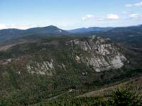 Whitewall Mtn
To the west of the main group, a couple of unnamed peaks lead to Whitewall Mountain (3405'), the dramatic eastern wall of Zealand Notch (2460'). There are no trails on this western branch, but Whitewall sometimes attracts intrepid bushwhackers/scramblers.
There seems to be consensus that the southern boundary of the Willey Range lies at Ethan Pond (roughly, along the Appalachian Trail). The height of land here is nearly 2800 feet, higher than the col to Mt Willard, so you could make an argument that the Willey Range should extend further south, perhaps to Carrigain Notch (2636'). However, names usually predate good maps and are rarely altered afterward.
History
 slides on Mt Willey
Mt Field is named for Darby Field, first recorded ascentionist of Mt Washington.
Mt Tom is named for Thomas Crawford, whose family lived in the notch that bears their name. Crawford Notch was "discovered" in 1771 by a hunter named Timothy Nash, who was granted land in the notch in exchange for a promise to build a road. The Crawford family first moved to the area in 1790; they were related by marriage to the Rosebrooks, who followed them in 1792. Both families ran inns and guided visitors up Mt Washington.
Trails and Trailheads
The Appalachian Trail (consisting here of the Ethan Pond Trail) does not climb this range, but follows its southern border while running east from Zealand Notch past Ethan Pond into Crawford Notch. The Ripley Falls trailhead at its eastern end is one of the two primary access points for this range, since the Willey Range Trail begins near this trailhead.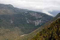 Mt Willard
The other long east-west trail in this area is the A-Z Trail, which, starting from a short ways up the Avalon Trail, passes over the col between Mt Field and Mt Tom, and then continues west all the way to the north end of Zealand Notch. The Crawford House trailhead at the eastern end of the Avalon Trail is the most popular trailhead for this range.
There is no practical distinction between the trailhead for the Avalon trail, in Crawford Notch just north of the park border, and the trailhead for the Mt Willard Trail. On old maps the trailheads are separated by two hundred feet, but sometime in the last few decades the bottoms of the trails have merged. The Mt Willard trail is a spur that climbs only one peak, but that peak possesses some of the best views in the range.
The three 4000-footers of the range are often traversed in a day using the Willey Range Trail, which runs from the Appalachian Trail at the southern foot of Mt Willey, over Mts Willey and Field to the col with Mt Tom.
Mt Tom's summit is reached by the Mt Tom Spur from the col.
The Avalon trail begins at the trailhead described above, climbs westward along a stream, then (at its junction with the A-Z trail) turns southwest to pass over its namesake peak on its way to Mt Field where it reaches the Willey Range Trail.
Finally, the Kedron Flume Trail provides a steep and damp shortcut up the southeast slopes of Mt Willey.
Getting There
The Willey Range is most often accessed from Crawford Notch State Park on U.S. Route 302. From the tourist town of Conway, follow route 16 north until 302 diverges westward. If you're driving up from, say, Boston, you can get to Conway by taking Interstate 95 to Portsmouth and exiting onto the Spaulding Turnpike (a.k.a. route 16). It may be faster, however, to take interstate 93 instead, turning easterly onto route 3 to reach 302 at Twin Mountain, turning east there to reach the north end of Crawford Notch.Red Tape
No camping inside Crawford Notch State Park. Parking inside the park is free, most trailheads outside the park fall under the WMNF parking program ($3/day). Willey Range from the east
Crawford Notch State Park extends along route 302, beginning south of the HIghland Center (at Elephant Head). The border passes to the east of the summit of Mt Avalon, and east of the summit of Mt Willey.
Areas outside the state park (with the exception of the Bretton Woods resort) lie within the White Mountain National Forest. WMNF rules limit camping, fires, etc. complete rules. Note that the Lincoln Woods Scenic Area covers the western part of the Willey Range, from the summits of Field and Willey to the summit of Whitewall. Additional rules also apply in the Pemigewasset Wilderness, which extends south and west from the Applachian Trail starting near Ethan Pond.
Camping
HutsThe AMC's Highland Center in Crawford Notch isn't like the other AMC huts; in fact the AMC calls this one a "Lodge". Still, it offers the nearest roof to the range.
Zealand Falls hut, open year-round, is located at the north end of Zealand Notch, at the western end of the Willey Range. A loop hike from this hut over the main peaks of the Willey Range via the A-Z, Willey Range, and Ethan Pond trails is entirely feasible in a day (13 miles).
Shelters
Ethan Pond campsite and shelter is located at the southern end of the range, about two miles west of route 302 along the Ethan Pond Trail (A.T.).
Roadside Camping
Dry River Campground is located at the south end of Crawford Notch State Park.
Backcountry Camping
Permitted outside the state park. See Red Tape section for link to complete rules.
Weather
All the peaks of this range are below treeline, so conditions on the ridge won't be much different from the valleys.