Layout designed for best viewing on a "1024 x 768" screen.
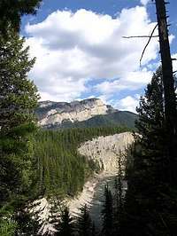
There are no roads that cross the Flathead Mountain Range in Northwestern Montana. With Glacier National Park as its neighbor to the east, the incredible Swan Range to the west and the massive Bob Marshall Wilderness Complex to the south, the peaks of the Flathead Range, with the exception of Great Northern Mountain, are seldom visited by climbers. The reason: Most peaks are difficult to access.
Pentagon and Pagoda, Trilobite and Turtlehead, Ousel and Condor, Helmet and Sergeant, Gunsight and Bow, Gladiator and Prospector; are all names of peaks in the Flathead Range. Perhaps each named peak tells a story that we will never know. Some peaks like Mount Cameahwait have ties to the Lewis and Clark Expedition; Cameahwait was Sacagawea’s brother.
A Look at the Numbers:
#
Total Named Peaks
82
Total Peaks over 8,000 feet
24
Total Peaks between 7,000 and 8,000 feet
48
Total Peaks between 6,000 and 7,000 feet
10
Total Peaks between 5,000 and 6,000 feet
5
Total Peaks between 4,000 and 5,000 feet
2
Total Wilderness Areas
2
Total Peaks with trails to the summits
13
Total Peaks with Roads to the summits
3
Total Peaks featured on SummitPost
3
Total Named Peaks along the Continental Divide
7
The Great Bear Wilderness:
The Great Bear Wilderness is part of the 1.5 million-acre Bob Marshall Wilderness Complex.
In September of 1964, the U.S. Congress passed The Wilderness Act which provided a vehicle to designate certain areas for preservation of wilderness.
In 1978 the Great Bear Wilderness was designated wilderness and protected a total of 286,700 acres of wild remote land in Northwestern Montana. By designation it is totally roadless and allows only foot and four-footed traffic on the 300 or so miles of trails.
The Great Bear Wilderness lies between Glacier National Park to the east and The Flathead Valley and Hungry Horse Reservoir and the Swan Range to the west and to the north of the Bob Marshall Wilderness Complex.
This area contains the densest population of grizzly bears left in the contiguous United States.
The Bob Marshall Wilderness Complex:
The Bob Marshall Wilderness was named after early forester, wilderness preservation pioneer, and Wilderness Society cofounder Bob Marshall. This region was set aside as the South Fork, Pentagon, and Sun River Primitive Areas in 1941, and finally designated as wilderness in 1964.
Here in Northwestern Montana is found one of the most completely preserved mountain ecosystems in the world. The kind of wilderness most people can only imagine: rugged peaks, alpine lakes loaded with fish, cascading waterfalls, grassy meadows embellished with shimmering streams, a towering coniferous forest, and big river valleys.
The Bob Marshall Wilderness Foundation is a great organization supporting the preservation and education about this incredible wilderness.
The Flathead National Forest:
Containing portions of the Bob Marshall Wilderness Complex, The Great Bear Wilderness as well as its own lands the Flathead National Forest is made up of 2.3 million acres. It extends 120 miles to the south from the U.S. – Canadian Border.
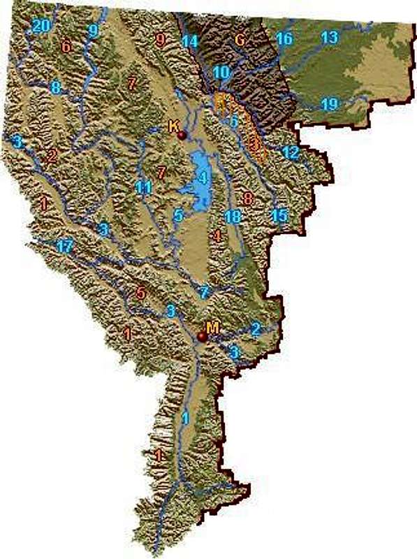
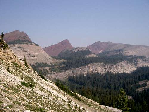
The Flathead Range, in Northwestern Montana, is primarily located in Flathead County.
The geographic boundaries:
To the west, the South Fork of the Flathead River and Hungry Horse Reservoir.
To the northeast, the Middle Fork of the Flathead River as it flows beside Glacier National Park.
To the southeast, The Continental Divide, marks the border of the range.
To the north, West Glacier, Montana is the terminus.
To the south, the range ends in the Bob Marshal Wilderness at border between Flathead County and Powell County.
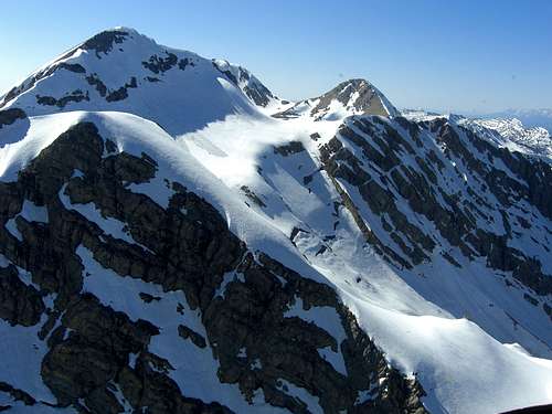
Like the Whitefish Range to the north, The Flathead Range is formed from cake-like layers of siltstone, mudstone and limestone that are thousands of feet in depth.
Grant Glacier
Glaciers continue to shape the Flathead Range. On the east side of Great Northern Mountain and Mount Grant are located Stanton Glacier and Grant Glacier. These glaciers are the real deal and caution must be exercised when traveling on them.
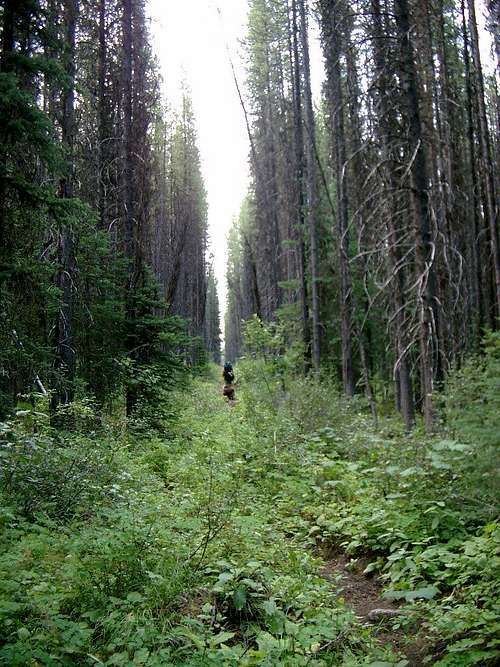
Streams have cut into the rock to form beautiful valleys. Above timberline exposed ridges allow for pleasant ridge walks between summits, but climbers must first endure the slog through the thick overgrowth.
During the last ice age small valley glaciers ground and slipped east and west and smoothed the jagged features of the range, leaving its valley floors strewn with unsorted rocks, boulders, gravel, sand and other debris.
The area averages 16.5 inches of rain annually and in the winters there is an average of 65 inches of snow in the valleys and over 12 feet of snow on the peaks.
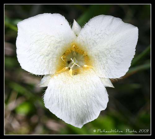
Pointed Mariposa Lily
There certainly are many opportunities to get up close and personal with the flora of the Flathead Range. Thickets of Devil’s Club and dense underbrush make it difficult to access many portions of the range and the hiking trails and game trails pass through many species of plants.
Like its neighbor to the east, Glacier National Park, the Flathead Range has an incredible number of vascular plants; Glacier has at least 1,132 species. The areas around the Flathead Range also contain 20 different tree species, 93 woody shrubs or vines, 88 annual or biennial plant species, and 804 types of perennial herbs. There are over 600 species of mosses and lichens. Sixty-seven vascular and 42 non-vascular plant species found in Glacier Park are listed as "sensitive" by the State of Montana; many of these same plants exist in the Flathead Range.
Trees that exist in the range include Western Red Cedar, Western Hemlock, and Grand Fir that prefer wetter climates as well as Engelmann Spruce, Douglas Fir and White Pine tend to live in moderate elevations. Sub Alpine Fir and shrub-like bushes are found at tree line. Western Larch, Ponderosa and Lodge Pole Pine can frequently be found on south facing slopes and White Bark Pine is found in places where there is abundant moisture and in the fall and spring.
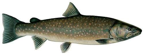
Bull Trout
Westslope Cutthroat Trout
The Flathead Range provides habitat for approximately 250 species of wildlife and 22 species of fish.
The following large wildlife species are found in the Flathead Range: grizzly, black bear, gray wolf, mountain lion, lynx, bobcat, wolverine, fisher, marten, whitetail deer, mule deer, elk, mountain goat, moose, beaver, otter, mink, bald eagle, golden eagle, owls, toads, frogs, salamanders, and many lesser species make their living in these mountains and waterways.
Fish species of special concern are the Bull Trout and the Westslope Cutthroat Trout. In recent years Lake Trout have been moving up the Flathead River system and displacing these incredible native fish. The western side of the range is protected by Hungry Horse Dam so genetically pure Bull trout and Westslope Cutthroat Trout are safe for now or until some "bucket biologist" dumps Lake Trout into the Hungry Horse Reservoir.
Mammal species of special concern include the grizzly as well as the Canadian lynx.
A Bird's Eye View
Native Americans lived in and passed through these mountains while en-route to the plains for hunting. They gathered food here and also found shelter from their enemies.
This area was explored by trappers and traders in the early 1800’s. The first recorded exploration occurred in 1854, when Captain John Mullan and his party explored the area near Spotted Bear on the South Fork.
John Mullan graduated from West Point in 1852, being assigned first to the topographical engineers, then to the artillery. He was a member of the Isaac I. Stevens party directed to Washington Territory, to explore on the way the country and a route for a northern railway to Puget Sound.
In the winter of 1853-54, Stevens left Mullan and Doty in western Montana to mark a wagon and railroad route from Fort Benton, on the Missouri River by way of Coeur d'Alene Lake to navigable waters on the Columbia. This was to become known as the Mullan Road, a route of supreme importance in development of the Northwest.
During the winter of 1853-54 Mullan reportedly traveled about 1,000 miles, crossing the Continental Divide six times from October to January. The survey expedition "determined the existence of an atmospheric river of heat, varying in breadth from one to a hundred miles, giving mild winters in the lofty regions of the Rocky Mountains" otherwise known today as the Jet Stream.
Source: The Third Millennium Online
The Flathead Range
Reaching the Flathead Range can be as easy as stepping out of the door of your car or as complex as planning an extended trip into the heart of the range. An extensive trail system in the southern portion of the range contrasts with the seeming lack of trails to the north.
Access to the Flathead Range can be achieved from roads along the Middle and South Forks of the Flathead River. The Flathead Valley offers multiple locations for those seeking to stay overnight or eat at the restaurants. See the Equipment and Maps as well as the Guidebooks and Links section for more information.
Northwestern Montana has a local airport, is served by Amtrak as well as bus service.
By Air: Glacier International Airport serves as the air hub for northwestern Montana. Horizon, Delta Connection and Northwest Airlines service this area.
By Bus: Northwest Montana is served by bus service.
By Rail: Amtrak arrives daily from Minneapolis or Seattle stops in East Glacier, Essex, West Glacier and Flathead.
By Road: The major highways serving northwest Montana include U.S. Highway 2 running east and west and running north to south are U. S. Highway 93 and Montana Highway 83. The Flathead Range is located 160 miles north of Interstate 90 which runs through the southwestern portion of Montana.
Rental cars can be secured in the Flathead Valley at and near Glacier International Airport. See Car Rentals in Montana.
Access to The Flathead Range is available from trailheads along the Middle and South Forks of the Flathead River as well as from Spotted Bear.
During the fall hunting season is in full swing as residents and non-residents pursue elk, deer and black bear in the Flathead Range. Special hunting licenses are required to hunt moose, mountain lion as well as mountain goats. Hunting grizzly bears and wolves is not permitted at this time.
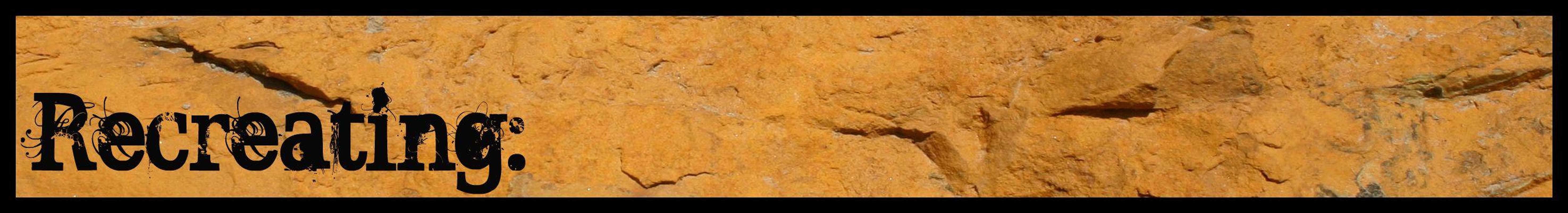
Hungry Horse Reservoir from the Flathead Range
There are many angling options for those who are so inclined. Although there are not a lot of lakes in the area it is possible to fish many of the small creeks as well as both forks of the Flathead River. One favorite lake for cutthroats is Spotted Bear Lake in the Flathead Range. These waters hold native Westslope Cutthroat as well as Bull Trout.
The Bob Marshall Wilderness has an extensive trail system for hiking as well as backcountry horse riding. For more details on the trails systems see the Spotted Bear trail report.
The Backcountry Horsemen have been influential in maintaining trails as well as building excellent relationships with sportsmen and women around the nation.
There is a grassroots effort to establish a Continental Divide Trail System of which part of that trail passes through the Flathead Range.
Backcountry Skiing and snowmobiling in Montana’s snow filled valleys and peaks is second to none according to those who do it. Check out the Glacier Avalanche link for the latest snow conditions. The Isaak Walton Inn has groomed nordic ski trails for visitors.
Mountain Biking single tracks and forest service roads is a great way to explore the range. With many of the USFS roads being closed to vehicle travel to protect animals, mountain biking has taken off and become quite popular in this range.
There are multiple opportunities to float in the Flathead Range. Glacier Outdoor Center and Great Northern Raft Company offer guided float trips on the Flathead River in Montana. Both of these companies are highly recommended. The owners are reliable, knowledgeable and are personal friends of this writer. If you have any questions or would like to book a trip please use their services.
For “Do It Yourself” trips many rafters float the Middle Fork from Schaffer Meadows or float the South Fork from it upper reaches to Meadow Creek Gorge near Spotted Bear.
For all of the rules and regulations of the Flathead National Forests see: MT Rules and Regulations.
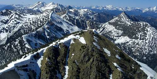
Peaks within the boundaries of the range stand at elevations between 4,724 and 8,882 feet in elevation. Access to most of these peaks is difficult even under the best conditions.
The tallest peak in The Flathead Range is Silvertip Mountain which stands at an elevation of 8,882 feet ( m) and is located in the Bob Marshall Wilderness area. Access to Silvertip is most easily gained from the Meadow Creek trailhead on the western side of the Bob Marshall Wilderness near Spotted Bear.
The shortest peak is Solitude Point at 4,724 feet located near the Spotted Bear Ranger Station.
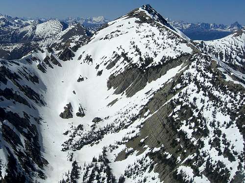
Great Northern Mountain, the 3rd tallest peak in the range, and Mount Grant, the 4th tallest peak in the range, are featured on SummitPost.
Located below is a list of named peaks that actually lie within the boundaries of the Flathead Range.
The following abbreviations provide information regarding the location of the peaks in the table below.
BMW = Bob Marshall Wilderness Complex.
GBW = Great Bear Wilderness.
FNF = Flathead National Forest
There are also peaks that lie along the Continental Divide between the Flathead Range and The Scapegoat Wilderness area. Of the peaks along the Continental Divide, the north peak of Three Sisters stands 12 feet higher than Silvertip Mountain at 8,900 feet.
Three Sisters, bakcast photo
Mountain Name
Elevation Feet
Elevation Meters
Three Sisters (North)
8,900
2,713
Redhead Peak
8,793
2,680
Three Sisters (South)
8,660
2,640
Three Sisters (Center)
8,630
2,630
Cliff Mountain
8,576
2,614
Hahn Peak
8,310
2,533
Salt Mountain
8,270
2,521
Silvertip Cabin
There are at 9 USFS campgrounds in or near the range. Those are Emery Bay, Murry Bay, The Devil’s Corkscrew, Elk Island, Fire Island, Devil Creek, Peter’s Creek, Beaver Creek and Spotted Bear. Information on these campsites can be found by contacting the Glacier View Ranger District at (406) 387-3800 or by going on-line government Cabin/Lookout and Campground reservation link below for Flathead Range Campgrounds.
Other motels and restaurants are available in the large towns that circle the Flathead Range.
Get back to history and stay at the Isaak Walton Inn in Essex, Montana.
The Isaak Walton was built in 1939 by the Great Northern Railroad. The Inn offers excellent food and lodging for travelers. The Inn also provides groomed cross country ski trails right out of the back door.
If there is interest in really getting back to nature consider booking a stay at one of the Forest Service Rental Cabins or Lookouts. The following rentals are available in the Flathead National Forests. To reserve these cabins go to Cabin/Lookout and campground Reservations.
Name of Rental
Description
Daily Rental Cost
Location
Zip's Cabin
The property Zip’s Place (cabin) sits on was originally part of a homestead granted in 1937. In 1945 the land was bought by the Kimmet family of Cut Bank, MT and in 1954 they constructed the cabin that resides there today. The structure is named for "Aunt Zip" who was the first in the family to own the property. On the cabin door, as well as a cupboard door above the stove, bite marks from the Geifer Grizzly of 1974-75 are still visible. The cabin, which borders the Great Bear Wilderness, was sold to the Forest Service by Tony and Lois Kimmet in 1993.
$50/night
Zip’s cabin is located 48 miles east of Hungry Horse, MT between mile markers 191 and 192 on US Highway 2. Travel south 2 miles on Geifer Creek (Lodgepole Lane) gravel county road veering left initially. Follow the signs to Zip’s cabin. In winter months, cabin access is via snowmobile/ski/snowshoe from plowed parking area on the same county road approximately 1.5 miles from the cabin. Summer (or when snow is melted and road is passable), you can drive to the cabin.
Challenge Cabin
The Challenge cabin is thought to have been built in 1925 by Evertt Hart. The construction is an example of a C-1 style building with dove-tailed corner jointing. It was originally used as a summer patrol station for numerous crews as there was no road access at that time. The external wall to the right of the door has signatures of past occupants that date back to 1932.
$30/night
Challenge Cabin is located 51 miles east of Hungry Horse, MT on US Highway 2, then eight miles south on Skyland Road #569. Park in the plowed area along US Highway 2, then hike, snowmobile, ski, or snowshoe the eight miles to the cabin along the groomed snowmobile trail. You cannot drive to Challenge Cabin.
Silvertip Cabin
Silvertip Cabin is located 55 miles south from Hungry Horse on Forest Road #38. The cabin is within walking distance to the Spotted Bear River.
$50/night
From the town of Hungry Horse travel on US Hwy 2 turn south at Martin City on Forest Road 38 which is paved through this small town and turns to gravel as you enter the forest. You will travel for approximately 55 miles on a winding gravel road along Hungry Horse Reservoir. At the junction with Diamond R Guest Ranch turn east on Forest Road 568 travel approximately 14 miles. Park at the trailhead and hike or ride on trail #228 for approximately 1/3 of a mile to the Spotted Bear River Trail #83 go past Trails #43 and #89.
Hiking in the "Bob", bakcast photo
The Flathead Range is accessible throughout the year. The Middle Fork of the Flathead River is followed by U.S. Highway 2 which is maintained all winter. From this thoroughfare access to the eastern side of the Flathead Range.
Access along the western side is more problematic during times of snow. The road along the west side of the range is closed to vehicle travel. It certainly would be possible to snowmobile along the East Side Hungry Horse Reservoir Road to access more remote areas of the range. Keep in mind that access to medical care would be a long drawn out procedure no matter what time of year but is even more protracted when the peaks are in the grips of winter. Backcountry users should also be familiar with avalanche safety when traveling during the winter. There is a link to the Glacier Avalanche Center in the last section of this page.
Generally the range begins to become snow free in mid-May and by early July most peaks would be accessible. Access to the range becomes day to day in late September due to cold nights that may result in snow and warm fall days resulting in generally wet conditions. By late October do not count on traveling to higher elevations in the range unless prepared for snow travel.
Hope for the best and plan for the worst. This phrase is very appropriate for describing weather in Montana. Weather can change at a moments notice and storms quickly arrive over neighboring mountain ranges. Check out the weather before starting climbs.
Climbers Guide to MontanaHiking Montana’s Bob Marshall Wilderness, by Erik Molvar
This is an excellent guide to the trails in the wilderness, giving not only mileage, condition and some illustrations of the trails, but fishing info as well.
Montana’s Bob Marshall Country: The Bob Marshall, Scapegoat, Great Bear Wilderness Areas and Surrounding Wildlands, by Rick P. Graetz.
This is a pictorial book of each section of the Bob Marshall Complex, from the Great Bear to the Scapegoat.
Flathead National ForestGlacier Avalanche Center
Children refers to the set of objects that logically fall under a given object. For example, the
Aconcagua mountain page is a child of the 'Aconcagua Group' and the 'Seven Summits.' The
Aconcagua mountain itself has many routes, photos, and trip reports as children.
Parents refers to a larger category under which an object falls. For example, theAconcagua mountain page has the 'Aconcagua Group' and the 'Seven Summits' asparents and is a parent itself to many routes, photos, and Trip Reports.

 27381 Hits
 94.02% Score
 45 Votes