
-
 57659 Hits
-
 87.31% Score
-
 24 Votes
|
|
Area/Range |
|---|---|
|
|
49.71932°N / 125.35272°W |
|
|
Hiking, Mountaineering, Ice Climbing, Scrambling, Skiing |
|
|
Spring, Summer, Fall, Winter |
|
|
Overview
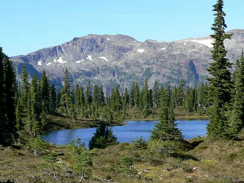 Forbidden Plateau. Sub-alpine meadows & forest, Hairtrigger Lake and Mt Frink Forbidden Plateau. Sub-alpine meadows & forest, Hairtrigger Lake and Mt Frink |
Looking at the boundary map of Strathcona Provincial Park on Vancouver Island, British Columbia, the casual observer could be forgiven for wondering about the odd-shaped extremity right on the eastern edge of the Park. This apparent afterthought is Forbidden Plateau, a readily accessible and absolutely stunning 250 sq km alpine plateau of open meadows and lush forest studded with lakes and tarns and all framed by high mountains.
  |
In fact, it’s a breathtakingly beautiful place. Countless gentle streams burble through flower decked meadows framed by sub-alpine forest. I’ve lost count of the number of times I’ve criss-crossed the Plateau trails and have never failed to be filled with a profound sense of peace. Quite the opposite of forbidden in fact.
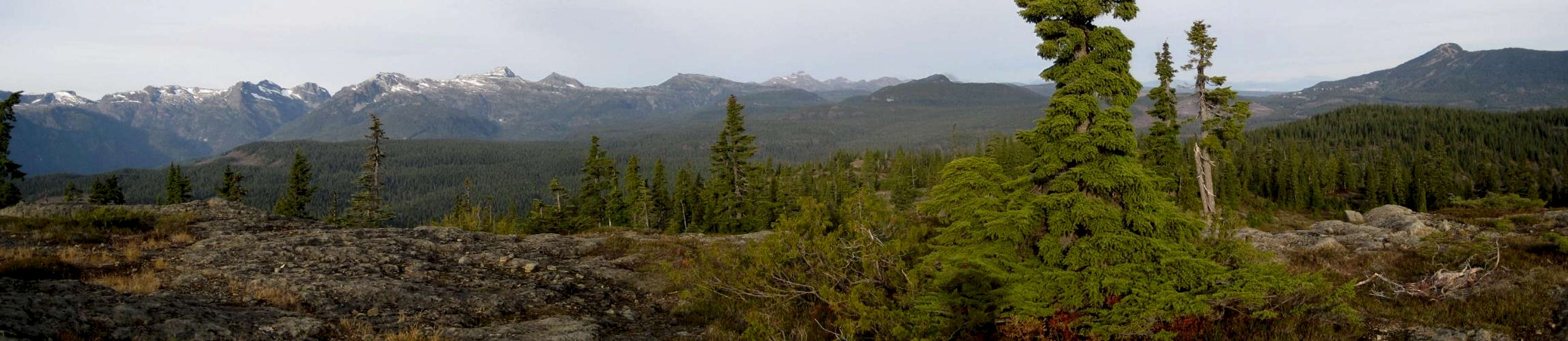
 Looking over Forbidden Plateau to the SE from Jutland Mountain. Mt Drabble in the distance. Cruikshank Canyon on the right Looking over Forbidden Plateau to the SE from Jutland Mountain. Mt Drabble in the distance. Cruikshank Canyon on the right |
Topography
The geographical boundaries of the Plateau are somewhat difficult to define.Certainly the western extremity is the range of mountains that overlook the area and are themselves separated from neighbouring ranges by the Eric Creek and Oyster River drainages to the south and west respectively. To the south and east are the Cruikshank Canyon and Mts Becher, Drabble and Wood beyond which the land drops rapidly to Comox Lake and the east coast respectively. The northern boundary is the most difficult to define as the height of land diminishes gradually into the Piggot and Oyster river drainages and thence to sea level. Long before this is reached, the Plateau has ceased to be protected by Parks and has been ravaged on all sides by logging.
The appellation “plateau” may conjure up images of flat and pleasant travel. There’s plenty of that but there’s a lot more undulating terrain, however, in and out of the many bowls that retain the myriad lakes in the area. For instance, the popular trip from Paradise Meadows to Circlet Lake entails just 50 metres elevation difference but more than 350 of total gain.
History
Man’s interaction with wilderness is very much a part of the detailed history of Forbidden Plateau and how it came to be part of Strathcona. Every single event that has contributed to this is beyond the scope or intent of this page. However, at least a well-sketched outline is essential if you are to fully appreciate all that you see during your visit and may encourage you to seek out some of the historically important areas.There is probably no more important a figure in the history of Forbidden Plateau than Clinton Wood. By the early 1920’s Comox Valley enthusiasts had already established a trail from Bevan, near Courtenay, onto the Plateau as a means of access to Mt Albert Edward. The difficulties of this trail convinced Wood that a better route was feasible and in 1928, along with Geoffrey Capes, he pioneered a route through from Dove Creek via Anderson Lake. The opening of this trail in 1929 did more than anything else to increase widespread interest in visiting the area and its subsequent development. By 1930 the route had been pushed through to Lake Helen McKenzie.
In those days the area was all Crown Land and control over its use seems to have been a laissez faire situation at best. Cabins sprang up all over the Plateau at Kwai, Circlet, McKenzie, Mariwood and other lakes for the purposes of the limitless fishing and hiking opportunities afforded by this hitherto seldom visited area.
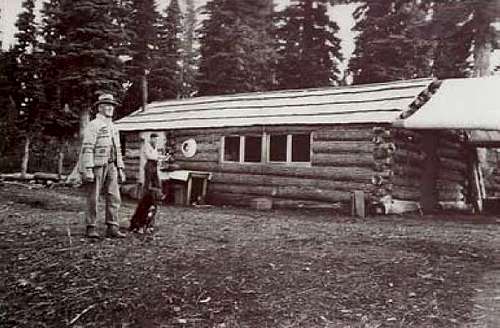
Substantial lodges for paying guests were built in 1929 by Eugene Croteau, at the lake that came to bear his name and in 1934 Clinton Wood himself built his Forbidden Plateau Lodge near the site of the subsequent ski hill of that name. The hill was, of course, eventually named Wood Mountain.
Perhaps the best remembered piece of the history of the Plateau attaches to Sid William’s activities. Sid and his friend Jimmy Aston had more than a passing interest in the mineralogical possibilities of the Plateau and spent the summers of 1946 and 1947 looking for what they could find of value. Several promising finds were made and the interest of large mining companies piqued but nothing of lasting worth came out of all that work and interest gradually waned.
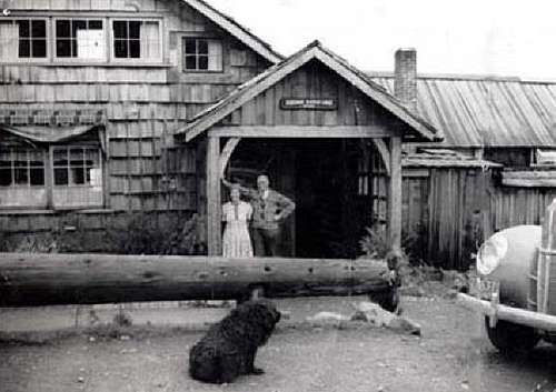 Forbidden Plateau Lodge Forbidden Plateau Lodge |
 Croteau Lake Cabin Croteau Lake Cabin |
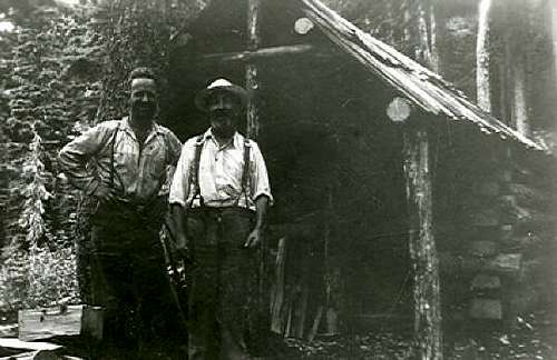 Sid's Cabin 1946 Sid's Cabin 1946 |
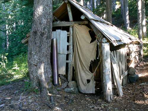 Sid's Cabin 2009 Sid's Cabin 2009 |
What has also lasted the test of time is the cabin that Sid and Jimmy, with the help of a young Ruth Masters, built as a base for their mining operations. Sixty two years on, the structure still stands as a safe and cozy haven from the storm, its continuance presumably a result of the mechanism of grandfathering of its status. It would now be illegal of course.
The golden years for Forbidden came in the 1980’s and 90’s. Nearby Mt Washington Resort developed its ski and summer operations to the point where visitors began coming in large numbers. The old gravel-and-washboard road up to the resort from near Dove Creek was paved and grandly renamed the "Strathcona Parkway" and even more came. Not content only with what the resort had to offer, folk soon began wandering in ever increasing numbers onto the adjacent, and aptly named Paradise Meadows part of the Plateau. To accomodate all this traffic - and what would otherwise have been a negative impact on the fragile local ecosystems - Parks built excellent trail, camping and support facilities. This was accomplished in an era when public money was plentiful and governments were far-sighted enough to listen to those they were elected to represent - and not, as today, grubbing their way into power by any and all means possible.
All gone by the wayside now I’m afraid.
BC Park’s budget for 2008 was $30 million for 650 Provincial parks. By contrast, Washington State Park’s budget was $100 million for 110 State parks and even Metro Vancouver Park’s budget received $21 million for 21 Regional parks.
The meagre $30M figure above, amongst other expenses, pays for 64 full-time equivalent rangers – less than 1 for every 10 parks. Much more important to the government is its Public Affairs Bureau which has 216 full time staff whose job is to control the information going out to the public and make the government look good; total budget $36,659,000.
What this means for Forbidden, Strathcona and, indeed, all BC Parks is no maintenance, no supervision and, worst of all, permission for 3rd party organizations to bring commercial operations such as horse-trekking into the park for the purposes of exploitation of its supposedly protected resources and in complete opposition to the governing master plan.
If you haven’t done so already, visit the area soon before things get worse!
Getting There
Vancouver Island can be reached directly by air from Toronto, Vancouver, Seattle, Calgary, Edmonton and recently from San Francisco to either Victoria, Nanaimo, Comox or Campbell River and by ferry from Port Angeles to Victoria on The Coho and on BC Ferries from Vancouver to Victoria or Nanaimo. Public transport on the Island is notoriously poor and anyone arriving by air would be advised to rent a car. Access in this case is on paved or main-line gravel roads and, therefore, fine with a normal sedan.The main access to Forbidden Plateau is from the Paradise Meadows trailhead. Approach from north or south on the inland Island Highway 19. Near Courtenay take the Strathcona Parkway exit west to Mount Washington Alpine Resort. Drive up 20km and just before reaching the resort make a left turn onto Henry Road, following Parks signs for Paradise Meadows. Pass the bottom of the ski lifts after 1.5km and drive a further 0.5km to the end of the paved road at the cross-country facility Raven Lodge. Parks have established a new trailhead and information booth right beside the lodge. (Paid for by donation and private fund raising of course – NOT the government).
The east part of the Plateau can also be reached from the old Wood Mountain ski hill – still known confusingly as “Forbidden Plateau”. Approach from the Inland Island Highway 19 and turn off at the Piercy Road exit. Drive ~ 1km towards Courtenay. Turn right onto Forbidden Plateau Rd. Drive back over the highway and proceed ~ 15km up to the remains of the old Forbidden Plateau ski lodge. The first 7-8 km of the road is paved and the rest is reasonable gravel.
Mountains
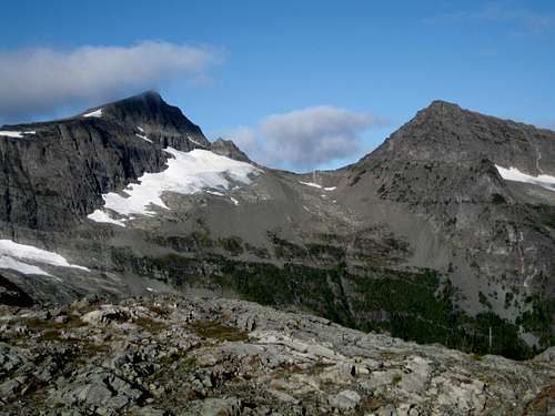 Mts Albert Edward & Regan, the signature summits of Forbidden Plateau
Here and there in the eastern quadrant are lower forested mountains, such as Mt Allan Brooks, that are sometimes climbed as day objectives all year round.
The links in the following compilation provide details on the approach and climbing routes on all the mountains generally associated with the Forbidden Plateau.
| Photo | Mountain | Height – metres | Brief description |
 |
Mt Albert Edward | 2,093 | The highest summit in the Forbidden Plateau area and the 6th highest on Vancouver Island. An easy walk up from Circlet Lake in 3-4 hours. |
 |
Mt Frink | 1,948 | The 3rd highest summit in the area. About 1.5 km SE of Albert Edward across the broad intervening plateau above Hope Lake. Gateway to the long traverse south to the Comox Glacier |
 |
Castlecrag Mountain | 1,740 | A low but rugged summit due east of Mt Frink across the head of the Eric Creek drainage. A good single objective from Circlet Lake but more usually climbed as part of the Castlecrag Horseshoe hike. |
 |
Jutland Mountain | 1,830 | Only 3 km NE of Albert Edward as the crow flies across the deep cirque containing Gem Creek and Lake 1000 metres below. But 6 km to walk there around the long SE/NW connecting ridge. |
 |
Mt Regan | 1,975 | The 2nd highest summit in the Forbidden Plateau area and, by far, the most difficult to climb. Climbed from the Albert Edward/Regan col via an approach that drops off AE’s approach ridge or by climbing the headwall above Gem Lake. Or climbed via the north ridge direct from the Gem Lake Trail. Exposure, glacier travel, Class 3/4 scrambling on loose rock and route finding difficulties. Crampons, axe and helmets well advised. |
 |
Strata Mountain | 1,443 | So-called as a result of the different coloured strata on the mountain’s upper slopes. Situated NE of Circlet Lake and usually climbed from there via a bushwhack from McPhee Lake or via a marked route that starts ~ 1km before reaching Circlet Lake. |
 |
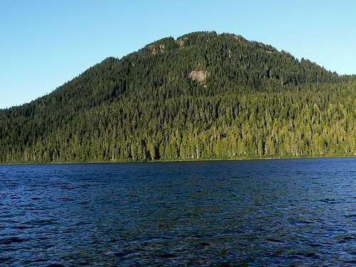
Mt Allan Brooks | 1,500 | The closest of the plateau mountains to the Paradise Meadows trailhead – about 3.5 km southwest - and directly above Lake Helen McKenzie, Mt Brooks is a popular winter destination on skis or snowshoes. Usually climbed from the pass between it and Mt Elma at the south end of the lake. |
 |
Mt Elma | 1,420 | Situated roughly in the centre of the triangle formed by Helen McKenzie, Croteau and Lady Lakes. Like Mt Brooks, Elma is usually climbed from the low pass at the head of Lake Helen McKenzie and is strictly a bushwack. It makes a nice backdrop to visits to Croteau Lake. |
 |
Indianhead Mountain | 1,300 | Hikers often walk the southeast through-route from the west part of Forbidden Plateau to the exit point at Wood Mountain, the site of the original Forbidden Plateau Lodge and ski hill. In spite of its diminutive size Indianhead’s bluffs are an impressive sight above Slingshot Meadows and the mountain is usually climbed from there. |
 |
Mt Drabble | 1,363 | Mt Drabble is easily climbed off the southeast through-route from the west part of Forbidden Plateau via Drabble Lakes. There is wonderful camping right on the summit and some of the best views in this part of the Plateau from there. |
 |
Mt Becher | 1,390 | As the closest mountain on the Plateau to Courtenay, Mt Becher has probably been receiving visits longer than any of its neighbours. The remains of a ski cabin can be seen on its lower slopes above Boston Lake and it’s still visited on skis more often than any other Island Mountain. Boston Falls is one of the premier ice-climbing destinations on the Island. Can be climbed from Slingshot Meadows, Wood Mountain, Boston Lake or Boston Ridge. |
Lakes
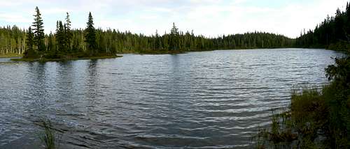 Battleship Lake
Oddly enough, the largest lake in the area – Helen McKenzie - is found in the less mountainous northeast quadrant. The deepest, however – Moat and Circlet Lakes - are found where you would expect them; directly below the high alpine ridges on the west edge of the plateau.
 Sunrise Lake Sunrise Lake |
 Circlet Lake Circlet Lake |
 Kwai Lake Kwai Lake |
 Drabble Lakes Drabble Lakes |
Wherever you wander on Forbidden Plateau, a spectacular alpine or sub-alpine lake is not too far away. Great or small, named or unnamed, deep or shallow, there are certainly so many that I can’t include them all. The selection I’ve chosen and embedded here are more a result of my personal preferences. Do feel free to attach your own.
 Moat Lake Moat Lake |
 Croteau Lake Croteau Lake |
 Ampitheatre Lake Ampitheatre Lake |
 Lady Lake Lady Lake |
Parks approved campsites have been deliberately located by three of the most picturesque lakes on the Plateau namely Helen McKenzie, Kwai and Circlet. This means, of course, that extra stress is laid on the immediate environment of these areas. Try to minimize this by practicing your best back country no-trace methods: keep to the established trails, respect roped-off areas, clean up all cooking scraps, use grey water pits, good toilet practice etc. All of Parks’ designated core area campsites are equipped with metal box food caches against animal incursion. Please use them.
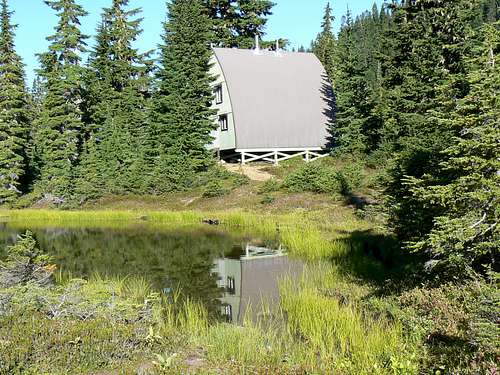
Buildings and Artifacts
The one-time more or less unrestricted access to Forbidden Plateau and the relatively recent incorporation of the area as a park, means that the numerous relics can still be found if you’re prepared to look.The site of Croteau’s camp still retains traces of the structure, as does Kwai Lake of the cabin that once stood there. On the slopes of Mt Becher, the original ski cabin’s foundations bear mute witness to the past. It fell into disuse, gradually rotted away and was finally burned down in 1980 after it became unsafe to enter.
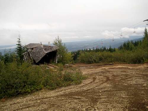 Defunct Ski Hill on Wood Mountain Defunct Ski Hill on Wood Mountain |
 Ranger Cabin Ranger Cabin |
 Old Plateau Signs Old Plateau Signs |
More modern structures can also be seen. The Wood family’s A-frames at Moat Lake as mentioned and the luxurious ranger cabin near Hairtrigger Lake. Mostly empty now and built back when the government had money and gave a damn! The defunct ski operation on Wood Mountain has left acres of devastation and a vandalized lodge to act as an eyesore all the way from the Comox Valley. Although, to be fair, this was never part of the incorporated area.
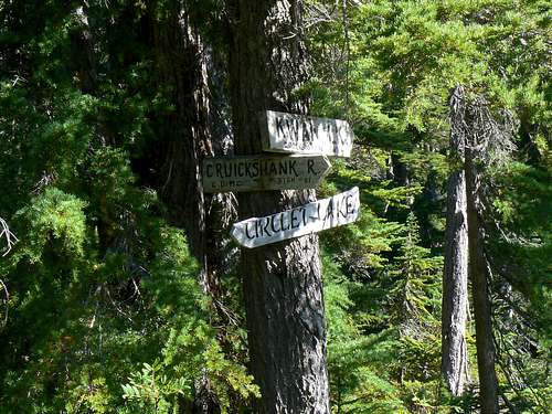
In the days before incorporation, the Comox and District Mountaineering Club installed hand-carved signs – many, if not most, made by Ruth Masters – throughout the Plateau many of which now point the way down long disappeared trails.
Suggested Trips
BC Parks map provides a nice overview of the many trails on Forbidden Plateau.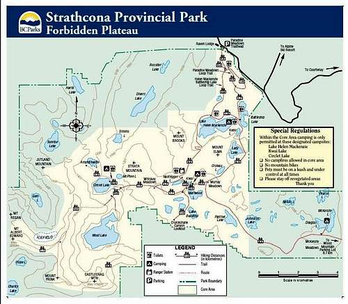 Forbidden Plateau trail map
© BC Parks
Of the thousands of visitors who come each summer, 90% venture no further than the popular circuit from Paradise Meadows to Lake Helen McKenzie, Battleship Lake and back to the start point - the so-called “Sawdust Trail”. In fact most of them get no further than Paradise Meadows.
 Paradise Ponds Paradise Ponds |
 Frosty Paradise Meadows Frosty Paradise Meadows |
 Cruikshank Canyon Cruikshank Canyon |
Forbidden has much more to offer. For a short day-hike from Lake Helen McKenzie, take the trail to Hairtrigger Lake via the ranger cabin and enjoy superlative views of Mt Albert Edward from there. Retrace your steps a few hundred metres and take the fork down to Kwai Lake. Turn right to Mariwood Lake and Lake Beautiful and on to the Cruikshank Canyon overlook with stunning views across the canyon to Castlecrag and Frink. Don’t go too near the edge! Return via Croteau and Battleship Lakes.
For a long day hike consider an out-and-back to Moat Lake (maybe the Woods will be in residence) or even a really big day on the Castlecrag Horseshoe or a summit of Albert Edward or Jutland Mountain – although these are usually done as overnighters.
Mts Becher, Indianhead and Drabble can be easily climbed in a day from the old ski hill access – although I’d encourage anyone to spend a night on Drabble just for the sunset views. Or if you’re out there with a tent and can make pick-up arrangements, carry on through on the 27 km route to Murray Meadows and on to the Paradise Meadows TH. The Dove Creek Trail pioneered by Clinton Wood is long since defunct but the original “Strathcona Trail” from Bevan – which it was meant to improve upon – is still around. If you’ve travelled through from the old ski hill you’ve walked much of it.
Red Tape
If you camp at Circlet, Kwai or Helen McKenzie Lakes, or anywhere else in the designated core area of Strathcona Park, there is a $5/person/day fee. There is a self-registration box and payment slot at every core designated trailhead. Payment can be by cash or cheque. Fill in the payment form before you leave and take the receipt slip with you.East of Johnson Lake - en route to Mts Becher et al from the west - you are outside the core area and have nothing to pay for, say, camping on Mt Drabble.
Camping
In general on Forbidden Plateau you are obliged to camp in the designated areas at Circlet, Kwai or Helen McKenzie Lakes.Note that fires are strictly prohibited, so you must pack a stove. Bear and cougar frequent the mountains and forests of Vancouver Island, so proper back country methods – hanging food bags out of reach, cleaning up all cooking scraps, good toilet practice etc – are essential. All of Parks’ designated core area campsites are now equipped with metal box food caches. Giardia is well documented throughout Strathcona Park, so boil or treat all water.
Useful Links
The history section above is meant to provide the merest taste of fascinating times-gone-by on Forbidden Plateau. For those of you who want more I refer you to the superbly informative web pages of our Island mountain historian, Lindsay Elms. Enjoy his stories on:Clinton Wood
Eugene Croteau
Mt Becher
Sid's cabin
And the many other biographies that he’s researched over the years.
Also useful is “Island Alpine – A Guide to The Mountains of Strathcona Park and Vancouver Island:, Philip Stone, Wild Isle Publications, 2003, ISBN 0-9680766-5-3 and/or visit Island Alpine Climbing Guide. This has its own sub-section on Forbidden Plateau and its trails.
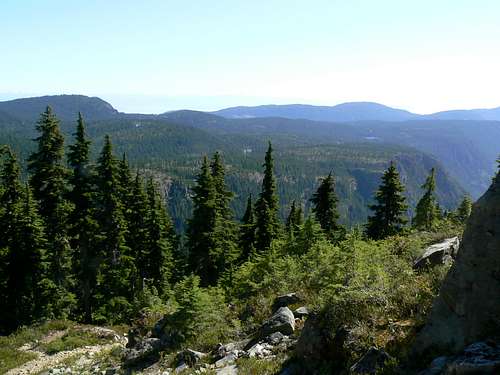
 Mt Brooks & Lake Helen McKenzie
Weather
Nearest point current conditions and forecast.OR
Check the weather at altitude right from Mt Washington’s webcam