
-
 10774 Hits
-
 87.76% Score
-
 25 Votes
|
|
Area/Range |
|---|---|
|
|
47.54412°N / 11.19181°E |
|
|
Hiking, Skiing |
|
|
Spring, Summer, Fall, Winter |
|
|
6844 ft / 2086 m |
|
|
Overview

Estergebirge is a range within the so called Bavarian Prealps (nevertheless those mountains are all belonging to the Alps and are NOT a kind of foothills) and is often seen as an independent area or range. Nearly the whole range is a huge karst plateau. Thus, Estergebirge is part of the Northern Limestone Alps.
The highest summit of Estergebirge, Krottenkopf , is the highest summit of the Bavarian Prealps. And to ad to this, Weilheimer Hütte, the only alpine club mountain hut within Estergebirge, is the highest mountain hut of the Bavarian Prealps.
To the west Estergebirge is limited by the Loisach valley with the villages of
- Eschenlohe
- Oberau
- Farchant
- Burgrain
- Partenkirchen
The Loisach river is one of the most important rivers of the region. Loisach valley offers several interesting geographical features (see below).
The eastern limitation is built up by the Isar valley and the Einsiedel valley from Wallgau to Walchensee. The main villages of the east side are
- Krün
- Wallgau
- Walchensee
To the south Estergebirge is limited by the valley which climbs steeply from Partenkirchen to Kaltenbrunn, Klais and Krün.
The northern limitation is the Eschenlaine valley between Eschenlohe and Walchensee / Einsiedeln. This is a lonely and remote valley with a forest road closed to public traffic.
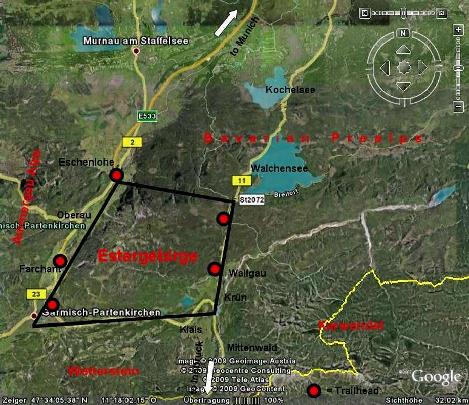
The adjacent areas and ranges are:
Ammergau Alps (to the west)
Wetterstein range (to the south)
Karwendel range (to the southeast)
Walchensee mountains of the Bavarian Prealps (to the north and east)

Getting There
Estergebirge can be easily reached from different directions; nearly all surrounding valleys and all main trailheads are easily accessible by car and even by train or public busses.
From Munich:
From Innsbruck and Inntal valley:
leave highway A 12 (toll road) at the exit "Zirl" and follow road number 177 to Scharnitz and road number B2 to Mittenwald and Krün. From there go on B2 to Partenkirchen and the Loisach valley villages or after Mittenwald on B11 to Wallgau, Krünand Walchensee.


Public Transportation:
The railway München - Innsbruck gives access to the Loisach valley and the Partenkirchen – Wallgau / Krün valley trailheads Eschenlohe, Oberau, Farchant, Partenkirchen, Klais. There are railway stations at these villages.
See the railway schedule here .
Regionalverkehr Oberbayern (RVO) runs the public bus lines in the valleys around Estergebirge. The lines number 9605, 9606, 9607 and 9608 do the service between Ohlstadt, Garmisch-Partenkirchen, Klais and Walchensee.
See the schedules here .
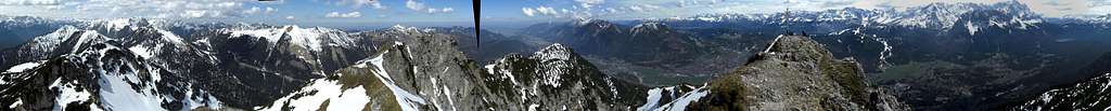
Summit Overview
Estergebirge is a more or less monolitic range with two exceptions: in the north and in the south there are subranges which are separated from the main range by hanging valleys.
The summits from north to south:
Simetsberg ridge:
This is an isolated, u-shaped small ridge at the northeastern limitation of Estergebirge.
- Simetsberg (1836 m; 6024 feet), a well known mountain for summer and winter (ski) hikes

Main ridge summits:
- Platteneck (1804 m; 5918 feet), a lonely subsummit
- Hohe Kiste(n) (1922 m; 6306 feet), wellknown to mountainbikers
- Archtalkopf (1927 m; 6322 feet), offtrail struggle
- Schindlerskopf (1940 m; 6365 feet), an offtrail dwarf pine hell
- Krottenkopf (2086 m; 6844 feet), wellknown main summit, often crowded
- Oberer Risskopf (2050 m; 6726 feet), easy stroll from Weilheimer Hütte
- Kareck ((2046 m; 6713 feet), easy offtrail walk from Risskopf or Henneneck
- Henneneck (1964 m; 6444 feet), quick detour from the trail Hoher Fricken – Weilheimer Hütte
- Bischof (2033 m; 6670 feet), easy hike from Hoher Fricken
- Hoher Fricken (1940 m; 6365 feet), popular spring, summer and autumn hike


Krottenkopf eastern subridge:
- Klaffen (1829 m; 6001 feet)
- Wallgauer Eck (1769 m; 5804 feet)


Wank ridge:
- Wank (1780 m; 5840 feet)
- Rotenkopf (1685 m; 5528 feet)


Mountain Huts & Cablecars
Mountain huts:

Cablecars:

Geographical & Geological Features
Estergebirge is a huge, oblique plateau, inclined to the east. Consequently the highest summits are all in the west of the range. Thus Estergebirge drops down steeply over about 1.300 m of altitude difference to the west (Loisachtal). It builds a steep rock slope with only one trail overcoming it.
To the east Estergebirge gets lower and lower reaching “softly” the valley ground between Walchensee and Krün.
To the south there is a not very prominent subridge culminating at the Wank summit, a mountain which stands directly above Partenkirchen.
The northern parts of Estergebirge around Eschenlaine valley are rather remote areas with the exception of the two northern main summits: Hohe Kiste and Simetsberg.
Estergebirge consists mainly of the limestones and dolomite rocks of the triassic Hauptdolomit / Plattenkalk. These limstones were built in a sort of huge lagoon and are now full of karst formations thus forming the biggest karst plateau of the Bavarian Prealps. There are famous karst caves (Angerlloch, Frickenhöhle, both accessible only for experienced speleologists) and an interesting karst spring above Farchant, called Kuhflucht . This huge karst spring and the subsequent cascades are one of the sightseeing highlights of Estergebirge and thus well accessible by different trails.


Kuhflucht has nothing to do with a cow that flees (which is the proper translation of this strange name) but derives from the altered Latin word “confluctum”, the confluence of this karst creek and the river Loisach. During the snowmelting period or after long rainy periods Kuhflucht spring has an immense delivery and builds a huge cascade formed by several adjacent springs which come directly out of the rockface. This spring drains nearly the whole Estergebirge (a catchment area of about 5 km²) which was proved with several tracer tests years ago.
The whole Kuhflucht valley is a landslide area and the movements of the rock masses are monitored tightly.
Another beautiful geographical item is Loisachtal between Farchant and Eschenlohe. Whereas the road and the railway use the west side of the valley, the east side is a lonely moor and marshland full of interesting plants and animals. Near Eschenlohe there are several neighbouring springs with a huge delivery, called “Sieben Quellen”. There is a forest road between Eschenlohe and Farchent using the very eastern rim of Loisachtal to avoid the moor and marshland. This is a very popular hike and bike trail.
Loisachtal groundwater supports Munich with fresh drinking water which is of top quality in Europe. The groundwater layers below the valley floor are several hundred meters thick.


Another interesting feature can be observed on the southern slopes of Estergebirge near the valley floor at Gerold and Kaltenbrunn and around Mittenwald: the so called “Buckelwiesen”, meadows with countless little humps. It seems like those mountain meadows are getting goose bumps. Their formation at the end of the last ice age is rather complicated and is related to frost and melting processes and to the karst features existing in this region.
If you feel like swimming after a hike through Estergebirge there are several lakes waiting for you. Wagenbrüchlsee, Barmsee, Tennsee and Grubsee, all between Gerold, Klais and Krün, are little moor and marshland lakes in depressions build by the melting glaciers of the last ice age. As moor lakes they have – despite of their height between 850 m and 920 m – warm water during summer times.

Walchensee on the other hand is a real challenge even in hot summers; the water is always very cold and there are mainly windsufers on (and sometimes in) the lake.
The Estergebirge hosts, despite of being a karst plateau, a little lake in a depression of the hanging valley between Platteneck and Klaffen: Wildsee. This, too, is a moor lake, a beautiful place amidst woods.
Accommodation
Hotels, Bed & Breakfast, restaurants and campgrounds can be found mainly in the following villages:


Mountain huts:
Red Tape
There are several protected wildlife sites with restrictions for ski touring and snow shoeing:
- two protection zones on the east side of Simetsberg; the ski routes are outside of these zones
- the karst wells "Bei den Sieben Quellen" south of Eschenlohe are a protected site
- Henneneck summit zone, Ameisberg, the north summit of Wank, Hoher Fricken east ridge, two parts of Bischof south slopes and meadows and woods north of Esterbergalm are winter protection areas for wildlife. All ski routes are circeling around those zones
Besides that, there are, as far as I know, no further special restrictions for hikers and mountainbikers.
Mountain Condition