Arizona's largest waterfall?
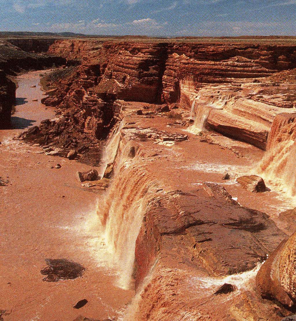
Arizona's largest waterfall?
"Grand Falls,"the locals call it Chocolate Falls,
is located on the Little Colorado River at the
far eastern edge of the San Francisco Volcanic
Field. Although the Little Colorado River is a
major tributary of the famed Colorado River, the
river's channel is bone dry most of the year.
To see the falls in ACTION, plan your visit for
spring runoff in March and April.
The creation of "Arizona's largest waterfall" is
directly linked to volcanic activity nearby. About
150,000 years ago, basalt lava from Merriam Crater
flowed as a river of magma for about 7 miles, to
where it spilled into the 200-foot-deep canyon of
the Little Colorado River. The hot, glowing river
of magma lapped up and over the canyon's opposite
rim and flowed downstream, following the river
channel for 15 miles before running out of steam.
This great mass of lava effectively dammed the
river. The river was forced to change course,
making a wide horseshoe bend to the east and
around the margin of the "hardening" lava. Over
time, the river carved a new channel and in the
process "excavated" portions of the lava that
filled its old channel. To reach its old channel,
the river flows in a spectacular fashion over
sandstone steps in the Kaibab Formation that once
was part of the north wall of the former Little
Colorado River canyon.
When the river is "flooded" with spring runoff or
flash floods from summer storms, this spectacular
cascade COMES ALIVE as "Grand Falls." Because the
river's water is usually muddy, natives living in
the area refer to it as CHOCOLATE FALLS. Actually,
the colour of the muddy water is MORE the colour
of a latte found at a coffee shop such as Starbucks.
The water continues north in the direction of its
eventual confluence with the mighty Colorado River
near Cape Solitude and Grand Canyon National Park.
Photo courtesy of Ralph Lee Hopkins, 1991
In September 1851, Captain Lorenzo Sitgreaves'
expedition left to find a wagon route between
Zuni, New Mexico and San Diego, California. They
were fifty-three strong, with more than 100 mules
and a flock of sheep. They descended the Rio de
Zuni to the Little Colorado, beyond the future
sites of Holbrook and Winslow, Arizona. The group
continued northward to GRAND FALLS, where they
left the river to strike west around the San
Francisco Peaks. They were without water for four
days. On October 12th, they discovered Leroux
Spring. The remainder of their journey was an
ordeal of starvation and Indian attacks before
they reached Yuma Crossing. They arrived in San
Diego on December 18, 1851.
(Courtesy of the Museum of Northern Arizona)
~ Because the falls are located in an isolated part
of Coconino County, please consult a topo before
your visit. Spring 2008 should be an AWESOME time
to visit this remarkable falls. Please note there
IS a picnic area nearby, so bring a sandwich and
ENJOY!!! ~

lcarreau
on Feb 27, 2008 8:41 pm


Comments
Post a Comment