
-
 70768 Hits
-
 92.04% Score
-
 37 Votes
|
|
Area/Range |
|---|---|
|
|
66.79624°N / 64.89624°W |
|
|
Hiking, Mountaineering, Trad Climbing, Aid Climbing, Big Wall, Mixed, Scrambling, Skiing |
|
|
Spring, Summer |
|
|
Overview
Baffin Island lies in the Canadian Arctic Archipelago just west of Greenland and is the world’s fifth largest island. Much like neighboring Greenland, Baffin contains all the elements that people generally associate with the arctic: midnight sun, the Aurora Borealis, expansive tundra, steep fiords, drifting pack ice, ice caps, glaciers, icebergs, polar bears, caribou, walrus, etc.; it’s all here. Many visitors are drawn to here to experience the Arctic wilderness, the Inuit culture, or the potential to climb in a very wild setting with virtually unlimited potential for exploratory climbing and first ascents.
The Canadian territory of Nunavut was established in 1999 and covers most of the Candadian Arctic Archipelago and the 'Barren Grounds' west of Hudson Bay and has its capital in Iqaluit on Baffin Island. Geologically, Baffin Island is part of the Canadian Shield consisting of ancient granite that is often more than a billion years old and up to 3.5 billion years in age. The highlands were deeply eroded during the previous ice ages resulting in some of the huge granite faces that exist today. The ice caps (the Penny and Barnes Ice Caps) are the last remnants of the massive Laurentide Ice Sheet that covered all of Eastern Canada and reached as far south as the Great Lakes and New England during the last ice age. Mountains run along the entire east coast of Baffin Island. This mountain chain is part of the Canada's 'Arctic Cordillera' that runs from Labrador's Torngat Mountains to northern Ellesmere Island. The western half of Baffin Island consists of rolling tundra plains, low hills, and many lakes and rivers.
From a climbing perspective, Baffin Island is best known for its big wall climbing, particularly concentrated on the Cumberland Peninsula and contained within Auyuittuq National Park and the coastal region near the Clyde River settlement where a large number of walls rise vertically from the sea. Besides big wall climbing, traditional mountaineering, ski touring, and ski mountaineering is possible throughout the mountain chain.
Mountaineering History
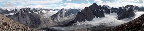
 Panorama along the shore of Summit Lake, Auyuittuq National Park.
Early European visitors included the Greenlandic Vikings one thousand years ago, who with obvious foresight into its climbing potential referred to Baffin Island as Helluland (meaning something like 'slabby rock country' in Old Norse). The first climbing expeditions visited Baffin Island in the 1950s. A Canadian-Swiss group in 1953 (including Jürg Marmet, who made the second successful ascent of Mt. Everest three years later) made many first ascents of major peaks in the Akshayak Pass region including Mts. Odin and Asgard. They also established a tradition of giving peak names based on Norse mythology, so that this region is sprinkled with an odd assortment of Norse, Inuktitut, and English names. Traditional mountaineering and ski mountaineering have been increasingly popular since the 1970s.
Big wall mountaineering came to Baffin Island in 1971 and 1972 with visits by British big wall climber and Himalayan mountaineer Doug Scott among others. New routes were put up on a number of rock faces including the classic free climb on Mt. Asgard the East Pillar (VI 5.10+). This was followed several years later by the amazing solo epic by Charlie Porter on the NW face of Asgard that was considered to be the first grade VII climb ever. This publicity, and the establishment of a National Park in 1972, resulted in the increasing popularity of Baffin Island. One of the largest uninterrupted cliff faces in the world is found on Thor Peak's overhanging west face. This was the site of much activity in the 1980s and 1990s when very difficult aid routes were put up. The West Face (VII 5.10 A4+)was attempted at least 5 times and resulted in the fatality of a Japanese climber before it saw a successful complete ascent. A good summary of some of the major big-wall routes on Baffin Island along with topos is found in the February 1996 issue of Climbing magazine and the 1996 issue of the Canadian Alpine Journal. Also, the Canadian Alpine Journal and the American Alpine Journal are some of the best sources of information for climbing routes, give ideas about conditions and challenges that can be expected on these, and sometimes even make for entertaining reading.
Regions and Peaks
Cumberland Peninsula
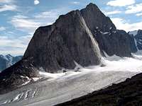
Mt. Northumbria in Auyuittuq National Park
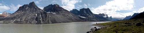
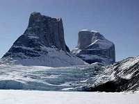
This region of Baffin Island is well-known for the impressive cliffs and mountains along the deep valleys of Akshayuk Pass. The most well-known landmarks are the two cylindrical towers of Mt. Asgard and the overhanging cliff face of Thor Peak. The highest point on Baffin Island is also here, although it is still debatable whether this is found on <a "href=https://www.summitpost.org/image/122479/152362/mt-odin-behind-mt.html">Mt. Odin's summit, Tête Blanche, or an unnamed snow dome on the Penny Ice Cap 25 km away. Most of this region is contained within Auyuittuq National Park, which is mostly covered by the Penny Ice Cap. Auyuittuq is Inuktitut for something like 'the Land that Never Melts', and ironically, the glaciers are melting fast and have been retreating significantly in recent decades. The popular Akshayuk Pass backpacking route traverses the park along the Weasel and Owl Rivers, and is one of the few marked trails in Nunavut. Parks Canada has erected 8 emergency shelters along the 90 km route, although sleeping in these is prohibited except for emergencies. Virtually all the major peaks and glacier approaches can be accessed from these valleys. Transportation into the park is via boat or a two day from Pangnirtung or by boat from Qikiqtarjuak after the ice break up. Ski-doo or skis are used during the ice months. Due to its more interior location, polar bears are not as common as along the coast, although polar bear tracks have been found on the ice of Summit Lake only a few years ago. Other peaks in the SP database include:
Mount Breidablik-Baldr
Mount Tirokwa
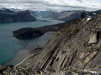
Second Turret and Broad Peak, Sam Ford Fiord
Clyde River Region
The region of Baffin's central east coast contains a number of impressive fiords, rock walls, and rugged granite mountains quite similar to the region around Tasermiut Fjord of Southern Greenland. The best known areas are Sam Ford Fiord, the Stewart Valley, and Ayr Lake. Feasibility studies are currently underway for the development of a large territorial park that could include a large portion of the central east coast, west to the Barnes Ice Cap, and from Clark Fiord south to Ayr Lake. Polar bears may be a problem here along the coastal areas. Summits in the SP database include:
Great Sail Peak
Polar Sun Spire
Bylot Island
Bylot Island is a large island on the northern tip of Baffin Island. This is one of Canada's newest national parks (Sirmilik National Park) and consists of a massive wilderness of ice caps, glaciers, mountains, fiords, and dense colonies of seabirds along several cliffs. Access is from Pond Inlet by boat or across the sea ice.
Getting There
Air Transportation
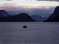
Alpenglow on Pangnirtung Fiord
There are no roads connecting any of the towns here, and virtually all visitors to Baffin Island arrive by air through Iqaluit, which has direct air connections to Ottawa. Other routes include Montreal by way of Kuujuak, and Calgary with several stops. An important consideration when planning a trip is the weather here, which very frequently prevents flights and boat traffic. It is quite common to be stranded in places for several days until the wind or fog allows air traffic to resume. For this reason schedules should be very flexible.
Flights to Iqaluit and beyond are through Air Canada, Canadian North, and First Air, while Kenn Borek Air also operates flights between Iqaluit and other points in Nunavut. Air Canada's frequent flyer program 'Aeroplan' offers flights between Ottawa and Iqaluit for only 15000 points and anywhere within Canada for 25000, which can be a great bargain for the more reaching the more remote locales.
Ground and Water Transportation
Most visits to the backcountry are multiweek expeditions to make the most of the trouble spent getting there. Depending on one's enthusiasm, ethical, and aesthetic sense, in addition to the season, access from the settlements to the peaks can be by done by any combination of motorboat, kayak, backpacking, skiing, or snowmobile. I think air supported expeditions are prohibited in Auyuittuq National Park.
Towns
Iqaluit:
Anyone travelling to Baffin will pass through Iqaluit, the capital of Nunavut and entry point to all other locations on Baffin Island. Free camping can be found along the Sylvia Grinnell River (there's even some small sport climbing crags here), while there are several very expensive hotels (more than C$160). There is a good restaurant and bar in the Frobisher Inn. There is a high likelihood that one will spend time in Iqaluit waiting for flights that have been delayed or canceled due to the weather.
View from Mount Duval above Pangnirtung.
Pangningtung:
'Pang' is the gateway to the southern entrance to Auyuittuq National Park. The National Park Visitor Center is a necessary stop to get the permits, pay the fees, and talk with the park wardens for destinations in the park. The ‘Angmarlik Visitor Center’ next door, can store baggage for you and can find you an outfitter for boat transportation to Overlord at the head of the fiord. Free camping (in theory I think there is supposed to be a fee) can be found in Pisuktinu Tunngavik Territorial Park at the edge of town, and has grill places (there is no wood), pit toilets, and wind shelters for tents (this is quite important). This is a common gathering place for people who have been stranded in town for several days. There is also a very expensive hotel in town.
Qikiqtarjuak :
Qikiqtarjuak or 'Qik' is the gateway to the northern entrance to Auyuittuq National Park, and is a necessary stop for those through-hiking the Akshayuk pass route. It should be noted that flights are often canceled due to fog, and that pack ice throughout the summer leaves boat traffic up to chance. There is an expensive hotel in town, and also free camping, although the pack ice that can strand you in town, can also bring in polar bears that can make camping less attractive.
Pond Inlet:
Pond Inlet is situated at the northern tip of Baffin Island and is an access point for trips to Sirmilik National Park. There is camping and a hotel in town. Boat travel can be limited by pack ice conditions. Flights are from Iqaluit and Arctic Bay.
Clyde River:
Clyde River lies about halfway up Baffin Islands east coast. From town transportation can be chartered for trips to the surrounding mountains. Boat travel can be limited by pack ice conditions. There is camping and hotel in town.
Regulations and Safety
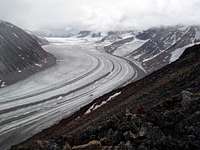
The Rundle Glacier
Fees and permits are required for visits to the national parks, with information found at the Parks Canada webpage. The major safety concern is river crossings, and a surprisingly high number of visitor fatalities are due to drownings in glacially-fed rivers. Choosing a crossing place is important, and the channels are usually shallowest where they are most braided, and the river the widest. Flow is highest in the afternoon and it may be necessary to wait to cross until about 4 in the morning when glacial run-off is lowest. Due to the glacial silt, it isn't possible to see the bottom of the streams, so trekking or ski poles are absolutely necessary to maintain balance and test for depth in these swiftly moving streams. Another good piece of equipment that I found very, very useful is neoprene booties as used by kayakers. These prevent your feet from becoming numb in the water that is only a few degrees above freezing.
Polar bears are the other biggest safety concern, and information on bear safety information can be found in a Parks Canada safety pamphlet. In the summer bears, which spend the rest of the year on the ice hunting seals, are trapped on the coast when there is no pack ice, and this is the leanest time of year for them. Firearms are not allowed in the national parks, so avoiding a confrontation is important. The most interesting recommendation is to sleep in a tent, since someone sleeping in the open in a mummy bag looks like a tasty seal!
Current Weather


Slightly better weather forecasts for Nunavut can be found at the Environment Canada website. Information about the sea ice conditions can be found at the Canadian Ice Service website.
References and Links
Maps
Toporama: Online topographical maps of Canada
Maptown: Topographical maps of Canada
Parks
Auyuittuq National Park: Parks Canada Webpage
Sirmilik National Park: Parks Canada Webpage
Nunavut Parks: Provincial Parks of Nunavut
Books
The Land that Never Melts: Auyuittuq National Park.
Roger Wilson. ISBN: 0887781438
Out of print and a bit out of date, but if you can find a copy, it provides quite a lot of useful background information about the natural and cultural history of the area. It also includes a field guide for plants and animals of the region.
A Naturalists Guide to the Arctic.
E. C. Pielou. ISBN: 0226668142
A nice book giving a very broad treatment of all aspects of the nature of the Canadian Arctic.
Inuksuit: Silent Messengers of the Arctic.
Norman Hallendy. ISBN: 0295981725
Many nice pictures from around Baffin Island of the rock cairns 'Inuksuit' (or singular Inukshuk), which can be rendered into English as 'that which acts in the capacity of a person'. The author recounts some interesting experiences, impressions, and interpretations about the Inuit culture, language, and spirituality.