
|
|
Mountain/Rock |
|---|---|
|
|
49.12100°N / 20.11800°E |
|
|
8287 ft / 2526 m |
|
|
Overview

Baranie Rohy and Ladovy Stit from Kolovy Stit
The main summit of Baranié Rohy is not exactly situated in the main chain of Tatra Mountains, but about 100 meters to the south in a lateral ridge. Vyšná Barania Stražnicá / Wyżni Barani Zwornik is a connected peak. Baranie Rohy ascend over Čierna Javorová / Czarna Jaworowa Valley (north-west), Vel’ká Zmrzla (Dzika) Valley (east) and Piatich Spišských Plies (Pięciu Stawów Spiskich) Valley. The north-east ridge connects Baranie Rohy with Čierny Štit / Czarny Szczyt (through Stolarczykovo Sedlo / Przełęcz Stolarczyka), the south-east ridge with Pyšný Štit / Durny Szczyt and Lomnicky Stit / Łomnica (through Baranié Sedlo / Barania Przełęcz) and west ridge with Snehový Štit / Śnieżny Szczyt and Ladovy / Lodowy Szczyt (through L’adové Sedlo / Śnieżna Przełęcz).
A large, sloping, scree terrace (Barania Galeria) fall down from the main summit to the south. This terrace, undercuted by high, rocky precipices, makes characteristic view from Piatich Spišských Plies Valley. But when you look at Baranie Rogi from north-west direction you can see a ram’s pate with two horns (the name means “ram’s horns”).
No marked trail leads on the summit, but each year a lot of tourists visit Baranié Rohy for a beautiful view.

Schema of ridges in Baranie Rohy area
First climbers:
in summer: Józef Stolarczyk and Ambrozy Trausyl with guides 17.09.1867
in winter: Tibold Kregczy, Lajos Rokfalusy and Zoltan Votisky 1911
 |  |  |  |  |
Summit view
A view from Baranie Rogi is not so large like from neighbouring Ladovy Stit, but interesting and beautiful.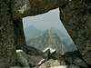 |  |  |  |  |
Getting There
From Slovakian side:
The major city in this area is Poprad, where you can get by bus or train. From Poprad there is a lot of buses and trains to Stary Smokovec (13km) at the foot of Tatra:
train time table
bus time table
train time table from Poprad to Stary Smokovec (Tatranská elektrická železnica)
Maps of Stary Smokovec and Tatransca Lomnica
From Polish side:
The best point to stars the journey is Zakopane – the biggest town on Polish side of Tatra Mountains.
Take a bus to Polana Palenica (time table of PKS, in high season there are a lot of private buses, too – a station is opposite to PKS) and get off in Lysa Polana. Cross the polish-slovakian border . Bus station on Slovakian side is about 100m after border crossing point on the right. Take bus to Poprad, which goes through Tatranska Lomnica and Stary Smokovec (time table).
In mountain:
Approach to Chata pri Zelenom Plese:
Take a bus from Stary Smokovec to Lysa Pol’ana and get off in Bela Voda. There is only a little parking-place among a forest and beginning of yellow marked trail, leading to Chata pri Zelenom Plese (about 2 h 45 min).
Approach to Teryho Chata:
From Stary Smokovec follow green marked trail to Hrebienok / Siodelko (you can take there cable railway (“lanovka”) – time table ) – 1 h 15 min. Next follow red marked trail in Skalnata Chata direction and after about 45 min turn left on green marked trail, leading to Teryho Chata (2 h).
 |  |  |  |  |
Routes overview
NORMAL ROUTES:
1. From Teryho Chata via Baranie Sedlo – the easiest and the most popular route on Baranie Rohy. It is only 2 h from Teryho Chata on the summit.
2. From Chata pri Zelenom Plese via Baranie Sedlo – longer and a bit difficult route than previous, but harder parts are protected by chains. Very difficult to find in a fog!
3. From Chata pri Zelenom Plese through Stolarczykovo sedlo – the most difficult from normal routes, but the most interesting.
CLIMBING ROUTES:
1. routes on the east face of Vysna Barania Straznica (Wyzni Barani Zwornik) – TOPO
Approach to wall:
From Chata pri Zelenom Plese take the red marked trail leading to Skalnate Pleso and after a few meters beyond a bridge on Biela Voda Kezmarska stream turn right (west) (through fence) on a non-marked, good treaded path. Follow this path, first along the south shore of Zelene Pleso, next among dwarf mountain pine (pinus mugo) and finally on screes to a high (100m), rocky step of Vel’ka Zmrzla (Dzika) Valley with two picturesque waterfalls. Ascend to a foot of the wall on the right from waterfalls to a beginning of a rib.
Climb through the rocky step following protective chains on a lower verge of Vel’ka Zmrzla Valley. Now, our rout leads by a bottom of the valley through screes and grass (follow cairns). A middle rocky step take to the left side and turn to the right corner of the valley (north-west), where our wall is situated.
· by left part of wall (1) – (UIAA IV+), 1,5h, TOPO, essential gear: 5 pitons
· by slab (2) – (UIAA VI-,A4,Ae), 12h, TOPO, essential gear: 20 pitons, 4 special pitons, 5 contraction bolts
· by a middle of slab (3) – (UIAA VI-,A4,Ae), 17h, TOPO, essential gear: 25 pitons (thins), 10 special pitons, 2 contraction bolts
· by an edge of slab (4) – (UIAA V,A1), 4,5h, TOPO
· by the right part of wall (5) - (UIAA IV+), 3h, TOPO
Maps
Tatry Wysokie, in scale 1:25 000, description in 6 languages, ISBN 83-87873-26-8, available in all shops in Zakopane. Here you can look at net version.
A high quality maps in scales 1:25 000 and 1:50 000 are produced VKU Harmanec, too. They are available at all chalets and shops in cities under Vysoke Tatry.
Red Tape
The “High Tatra” is a National park, UN Bioheritage area and a European BioHeritage - if you are not a member of any climbing club you can move only on marked trails - so you can visit Baranie Rohy only with tatra guide.
In winter time (from November the 1st – June the 15th) The Tatra Mountains in slovakian part are closed for normal tourists.
For more informations look at High Tatra/Vysoke Tatry GROUP page.
For climbing regulations look at Gerlachovsky Stit page.
When To Climb
The best time is a late summer and early autumn (august-september). Till June – July there is usually an old snow on a bottom of couloirs and in October usually starts new snow. However Baranie Rohy is easily accessible in winter, too. |  |  |
Accomodation
There are 2 chalets near by Baranie Rohy:
Chata pri Zelenom Plese (“Brncalka”) situated in Bielej Vody Kezmarskej (Kiezmarska) Valley on the eastern bank of the Green Mountain-lake („Zelene Pleso”). Chalet is opened all the year for hiking, climbing and ski mountaineering.
Access from:
· Tatranske Matliare, blue marked path (3 h 30 min)
· Bela Voda, yellow marked trail (2 h 45 min)
· Skalnate Pleso, red marked trail (2 h 15 min)
· Tatranska Kotlina through Chata Plesnivec, green/red trail (3 h 30 min)
· Tatranska Javorina through Kopske Sedlo, blue/red marked trail (4 h)
Contact:
Telephone: ++421-52-4467420
mobile: ++421-903-467420
Email: jgantner@stonline.sk
Teryho Chata (“Terinka”) situated in Piatich Spisskych Plies (Pieciu Stawów Spiskich) Valley. Chalet is opened all the year for hiking, climbing and ski mountaineering.
Access from:
· Zamkovskeho chata - green marked trail, 2 hours
· Skalnate pleso - red marked trail, 2 h 50 min
· Hrebienok - green/red marked trails, approx. 3 h
· Zbojnicka chata via Velka Studena dolina and pass Priecne sedlo, yellow marked trail, 3 h
· Tatranska Javorina - via Javorova dolina and pass Sedielko green marked trail, 6 h
contact:
Téryho chata, 062 01 Starý Smokovec, Slovakia
telephone: ++421-52-4425245
mobil ++421-905-893 233
Absolutely no camping is permitted in the nature park. The nearest camping is in Stara Lesna and Tatranska Lomnica.
There are plenty of cheap hotels and pensions in the area of Stary Smokovec and Tatranska Lomnica.
accomodation
 |  |
Mountain Conditions
Web forecast:
situation at this moment and forecast
Information of avalanche danger:
TOPR (in English) and HZS
Rescue:
On Slovakian side acts HZS (Horska Zachranna Sluzba)
Starý Smokovec 23, 059 60 Vysoké Tatry
phon.: 052/4422820, fax: 052/4422855,
mobil: 0903624869
e-mail: vtatry@hzs.sk
www.hzs.sk
TomaszRT - Nov 26, 2010 4:37 am - Hasn't voted
AccomodationTeryho chata ... · Zbojnicka chata via Velka Studena dolina and pass Priecne sedlo, yellow marked trail, 3 h ... Trail between Teryho chata and Zbojnicka chata via Priecne Sedlo is one-way (Teryho->Zbojnicka). Going opposite way is forbidden.