
-
 4462 Hits
-
 74.01% Score
-
 4 Votes
|
|
Route |
|---|---|
|
|
36.82512°N / 3.84011°W |
|
|
Hiking, Scrambling |
|
|
Spring, Summer, Fall |
|
|
Half a day |
|
|
Class 4 |
|
|
Hike and Scramble |
|
|
Overview
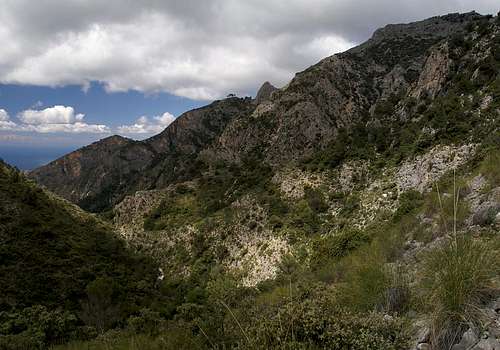 Almendron above Barranco de Cazadores Almendron above Barranco de Cazadores |
Of the two routes to the Almendron summit, the one through Barranco de Cazadores is the longer one. It also offers mor diffculties as parts of the canyon walls have collapsed over time and the route often crosses these rockfall areas on loose scree. Also, the elevation difference to the summit is considerably higher as you often have to climb high on the slopes to avoid obstacles on the barranco floor.
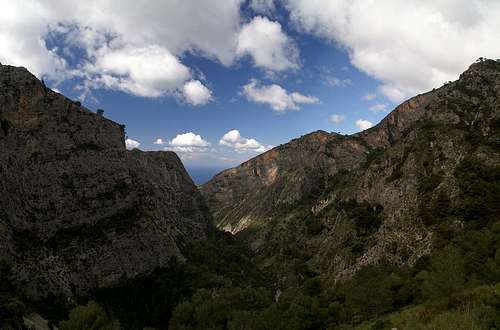
The route to Sierra de Almijara's highest summit, Navachica, also runs through the Barranco so that you'll often encounter climbers headed for either summit. The barranco itself is narrow and overgrown and thus offers no good views. However, after you climb out of it along a side-Barranco you are directed to the saddle Nido del Buitre, located to the north of Almendron. From there you have breathtaking views into the Chillar Valley and towards the main ridge of Sierra de Almijara.
Getting There
 Nido del Buitre and Tajo del Sol
The main page describes how you can get to the Almendrón trailhead. The routes start at the picnic area El Pinarillo, which is located at the mouth of Barranco de Cazadores.
Route Description
 Barranco de Cazadores
- Start altitude: 300m
- Summit altitude: 1514m
- Prevailing exposure: E
- Type: Hike and exposed scramble
- Protection: None
From the parking lot in Maro follow the dirt road which leads to the picnic area El Pinarillo (also possible by car). Cross the picnic area and descend into the barranco, only to climb out of it on the other side. You'll reach another dirt road which you have to follow to the right. At the first possibility leave it on a path which heads for the Barranco.
The first part of the route follows the canyon on its floor. To both sides massive limestone walls head skywards but the route itself follows easy terrain. After 30 min you'll reach the first obstacles. At first the path climbs through fallen rocks, then turns left to climb through the western slopes of the canyon. Th ground is very loose and orientation is difficult. After a short but steep ascent you find yourself on one of the paths which were built to allow access to the mines, which in former times were operated within the barranco.
You'll reach a spot where rockfall has eliminated the path . Pass the spot to its right, descending 20m into the barranco, then heading back to the path again. It follows the slopes and gradually gets closer to the barranco ground again. Where it does you'll see the remains of the former mines: ruins of buildings as well as unprotected mine entrances. Take care not to drop into a hole in the ground.
After the mines the path again follows the barranco but soon the next obstacle forces it to climb the western slopes again. It returns to the barranco ground which now has become much more shallow. Look for a big stone cairn, which marks the spot where you have to leave the valley floor. It is located right after a left bend in the path.
From here a narrow path heads up a steep side valley of Barranco de Cazadores. It stays on the south slopes of this valley and tops out onto the Almendron east slopes after having passed several bizarre towers. At this point orientation gets tricky. Following the path will lead you to La Puerta and thus away from the summit. A second path leads to Nido del Buitre, a saddle to the north of Almendron. I recommend to take the latter, mainly because the views from the saddle are breathtaking.
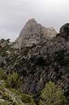
 Barranco de Cazadores Barranco de Cazadores | 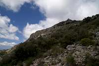 Almendron summit Almendron summit |
From the saddle return for several hundred metres and then fight your way up to the Almendron north ridge. Be sure to hit it early on since the upper sections of the Almendron slope is formed by steep slabs and blocks. We turned to the ridge to late and had to fight our way through dense bushes across these slabs. LAter we found a better access route a bit north of where we came.
Follow the ridge on its eastern side. A scramble takes you to the blocky part on to where you have to cross over to a ledge on the very exposed western side of the mountain. The ledge leads to a small almond tree near the summit of the mountain, from where a second exposed climb takes you to the top.
 |  |  |  |  |