Becca Pouignenta (Poignenta, Poeignenta or Pouegnenta), lies between the central valley and the small hanging valley of the Arpy Lake
(2.066m). It is a characteristic peak with three Summits: North
(2.827m), Central
(2.823m), and South
(2.787m). A large wooden cross (over two meter high) and a lightning rod are located on its highest point; from there the spectacle of the Mont Blanc and Monte Rosa Massifs is exceptional and one can enjoy grand views of the nortwest side of Mount Paramont and its satellites. The north face of the peak, clearly visible from the towns of Valdigne, drops almost vertically for about 700 m towards the Village of La Salle, while the west face, also a sheer wall, drops for about
800m to the Arpy Lake
(2.066m). The east side, from the Folliet Cross
(2.293m) is the easiest to climb, in spite of its length, because no rocks need to be negotiated.
First Ascents
- First on the summit: Unknown.
- In Winter: Unknown.
Getting There
BY CAR:
- From Torino, Milano, etc: Motorway A5. Exit at Morgex.
- From Switzerland: through the Grand Saint Bernard Tunnel or the namesake Pass.
- From France: through the Mont Blanc Tunnel or Petit Saint Bernard Pass: It is not necessary to take Motorway A5: you can drive on SS.26, in the direction of Aosta.
BY PLANE:
- Aeroporto "Corrado Gex" Saint Christophe (Aosta).
Route
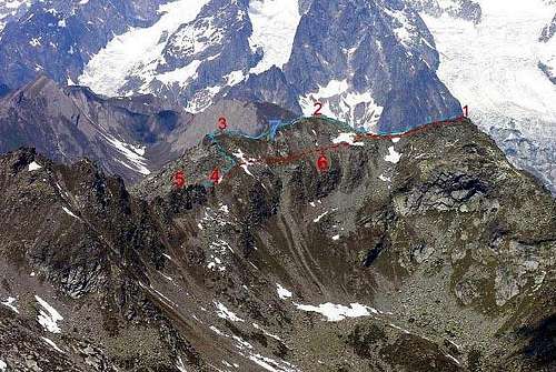
Ascent from LAGO DI PIETRA ROSSA
About
500m past the exit (in the direction of Courmayeur) turn left following the sign for the Village of Arpy (
1.690m, about 10 km from Morgex). Go past the village and, after another 5 or 6 km and many switchbacks, reach Colle San Carlo
(1.951m) where the Hotel/Restaurant "La Genzianella" is located. Park in the large lot in front of the hotel where the dirt road for the Arpy Lake starts (
2.066m,
40/45 min from the parking lot to the lake). Border the lake for about
100m and cross the stream where it is easiest. Continue on the left towards Lago di Pietra Rossa (follow the yellow arrows). Here the trail gets steeper and more strenuous. Once on the detrital plateau, keep right (the left trail leads to the Via Ferrata). After climbing roches moutonnées you reach Lago di Pietra Rossa (
2.558m,
1h'00/1h'30 min from Lago d'Arpy). Follow the left bank of the lake, climb grassy slopes and then aim directly for the moraine that leads to the Ameran Pass
(2.669m) among large boulders. The final stretch covered by grass. From the pass start a steep traverse on the slope, still grassy, but at times laden with scree. After
200m this traverse leads to a gully just under the north summit. This gully is shorter, but less advisable than the more logical and rewarding south ridge, which allows one to touch all three summits. Keep a short distance to the right (east) of the crest of the ridge (exposed) and, after passing the first two summits, reach the gully under the North Summit. Follow the narrow ridge (a few steps of I+) and attain the summit climbing large broken rocks. Keep at a safe distance (on the right) from the west and north faces. (
1h'30 min to 2h'00 from Lago di Pietra Rossa.) Descend retracing your steps.
Difficulty
The route is rated F (easy), but it requires a few climbing moves (I+) with some exposure.
Equipment for the Route
Standard mountaineering equipment.
Campings
Remember that free camping is forbidden (except for emergency reasons, over
2.500m, from darkness until dawn).
Mountain Condition
- Meteo: you can find all the needed informations at the official site of the Valle d'Aosta Region:
- Valle d'Aosta Meteo
Webcam
- WEBCAM on Aosta Valley:
- Webcam
Books and Maps
BOOKS:
- "Guida delle Alpi Occidentali", di Giovanni Bobba e Luigi Vaccarone C.A.I. Sezione di Torino Volume II (parte II), 25 Maggio 1896.
- "Guida dei Monti d'Italia – Alpi Graie Centrali" di Alessandro Giorgetta, Club Alpino Italiano/Touring Club Italiano, 1985.
- "La Thuile e dintorni" di Giuseppe Alliod, Ed. G. Alliod (1994).
- "Valle d'Aosta in Sci", di Rosanna Carnisio, Silvana e Guido Albertella, Ed. CDA Torino, 1993.
- "Pelli di Foca in Valle d'Aosta", di Franco Lenzi Editoriale Pedrini Torino, 1988.
- "Valdigne gli itinerari escursionistici", di Alessandro Giorgetta, Ed. Zanichelli, Giugno 1981.
- "Monte Bianco Valdigne" di Alessio e Giuseppe Nebbia, Ed. Musumeci, (1989).
MAPS:
- Kompass "Massiccio del Monte Bianco Valle d'Aosta Sentieri e Rifugi" Carta turistica 1:50.000.
- Kompass "Gran Paradiso Valle d'Aosta Sentieri e Rifugi" Carta turistica 1:50.000.
- L'Escursionista "La Thuile-Piccolo San Bernardo" Carta dei sentieri (n° 2) 1:25.000.
- Enrico Editore Ivrea-Aosta "Gruppo del Gran Paradiso" 1:50.000.
- I.G.C. Istituto Geografico Centrale Torino "Monte Bianco-Courmayeur-Chamonix-La Thuile" (carta n° 107), 1:25.000.
- I.G.C. Istituto Geografico Centrale Torino "Massiccio del Monte Bianco" (carta n° 4), 1:50.000.
- A.I.A.T. La Thuile, "La Thuile Pianta dei Sentieri", 2004 (Plastico).
- Studio F.M.B. Bologna "Monte Bianco-Mont Blanc" 1:50.000.
- I.G.C. Istituto Geografico Centrale Torino "Il Parco Nazionale del Gran Paradiso" (carta n° 3) 1:50.000.
- Comunità Montana Valdigne Mont Blanc, "Les Sentiers" Edizione 2001, 1:50.000.
Important Information
Useful numbers
- Protezione Civile Valdostana località Aeroporto n° 7/A Saint Christophe (Ao) Tel. 0165-238222.
- Bollettino Meteo (weather info) Tel. 0165-44113.
- Unità Operativa di Soccorso Sanitario Tel. 118.
Acknowledgements
I want to thank my two SP friends who respectively helped me to prepare the text (Livioz) and mainly to translate it Fabio (Brenta).

 8676 Hits
 92.32% Score
 38 Votes