
-
 14534 Hits
-
 84.01% Score
-
 18 Votes
|
|
Mountain/Rock |
|---|---|
|
|
42.59513°N / 0.82732°E |
|
|
Mountaineering, Scrambling |
|
|
Spring, Summer |
|
|
9941 ft / 3030 m |
|
|
Overview
 Ridge Mig-Nord
The long ridge of Besiberris is one of the most famous among the mountaineers that love the Pyrenees. The name Besiberri group three peaks (Nord, Mig and Sud, it mean North, Middle and South) but generally the peaks Comaloforno and Passet are included in the range.
In this area between the great mountains of valley of Benasque and the beautiful park of Aigüestortes this mountains have inaccesible aspect and height over 3000 meters, a perfect combination. The itineraries to this mountains are difficults and generally only mountaineers with experience must to climb. Some easy route is possible to the peak Besiberri Sud (F or F+) or the peak Besiberri del Mig (F) but generally the routes are PD or PD+ over ridges and walls exposed (rope is very advisable).
The access to the peaks is individualized but the most classical and beautiful route is the full ridge. The most complicated part of the ridge, with an only way without exit in both faces, join Besiberri Nord and Mig. The col of Trescazes between the peak Sud and Mig is the first escape from the ridge (it's very important to choose a day with good weather conditions).
As curiosity, this range has a highest mountain (Comaloforno) but the Besiberris are most beautifuls, it’s a rare case in Pyrenees what the less high mountains are most famous.
Besiberri Nord (3015m)
 Besiberri Nord
The most attractive summit, a great rocky cone but the access to this peak is the most complicated part of the range. It's join with the Besiberri del Mig across a narrow and exposed ridge with three gaps (Bretxa Oliveras, Brecha Sallés and a third Bretxa without name). Generally is possible the climb and descent for the coulouirs and walls of east ridge but as well the summit is the point of beginning of the route of full ridge. As variation is possible the climb for another walls near of Bretxa Oliveras reaching the summit across the south ridge but it's not a normal route.
Routes: east ridge (PD+), west face (PD).
 |
 |
 |
 |
Besiberri del Mig (3003m)
 Besiberri del Mig
Really has 2 twin peaks, Pic Simó (3002m) and Pic Jolis (3003m). The IG of Cataluña give the height of 2994 and 2995 meters to the summits. My GPS give to me 2998 and 3000 meters. For the moment both peaks are in the official list of 3000m.
Simó and Jolis was a famous mariage of mountaineers of Cataluña.
Routes: east ridge (F+), pas de Trescazes-west face (F), ridge from Besiberri Nord (PD+).
 |
 |
 |
Besiberri Sud (3030m)
 Besiberri Sud
In some maps and books appears with the height of 3017meters. 3024m with my GPS and new maps. 3030m is the height in the official list of peaks of 3000m. This peak appears lightly separated of the ridge and it has an evident col with the Mig what it's possible to reach with a simple walk-up (pas de Trescazes) but the access to this col it's generally the only point with snow in first weeks of summer. The route of estany of Gémena is a good option to reach a summit of 3000m not difficult without rope and crampons on summer. It's long but nice. It's the most frequented summit.
Routes: south-east face (F+), col d’Abellers-west ridge (F+), pas de Trescazes-north ridge (PD).
 |
 |
 |
Comaloforno (3033m)
 Comaloforno
The highest point of the full area but less spectacullar, it’s a confuse great ridge with some aiguilles and the main peak it’s less visible.
Routes: North ridge (PD) from Besiberri Sud or across the west face (P.D.inf.). In order to show the information of the routes of the highest point I write a page only for this mountain: Comaloforno.

Punta Passet (3002m)
 Passet
The IGC give actually 2998m to the last peak of the ridge of 3000m of the area. It’s join to Comaloforno across a gap and a ridge and generally is a complementary climb.
Celestin Passet was a famous guide and climber of the first years of pyreneism.
Route: the normal and only route is from Comaloforno with the return for the same way (PD).
Getting There
 Taüll
TaüllAccess to the area of Alta Ribagorça
-From France in the north across the tunnel of Vielha from the area of Pau-Tarbes to St. Girons.
-From Spain: Huesca and Zaragoza across Barbastro. C-1311 to Grauss and Benabarre. N-230 to Pont de Suert and the villages of Caldes de Boí, Boí or Taüll.
Trailheads: Estany de Cavallers (1.785m, 3 km to north of Caldes de Boí), Caldes de Boí (1.490m), Conangles (1.585m) or Tunnel of Vielha (1.550m)
Red Tape
Important note: in many maps and book you can read about the free hut of Besiberri in Brecha Peyta. Nowadays this hut don't exists.Some part of the route from Estany de Cavallers is in the Naturak Park of Aigüestortes.
Camping
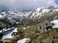 Ref.Ventosa i C.
Campings and hotels in Boí, Taüll, Caldes de Boí… in winter the ski resort of Boí-Taüll is working.
In the area is the refuge Ventosa i Calvell but it's a little separated of the normal routes to Besiberris.