
|
|
Mountain/Rock |
|---|---|
|
|
46.12890°N / 115.1805°W |
|
|
Idaho |
|
|
Hiking |
|
|
Summer, Fall |
|
|
7122 ft / 2171 m |
|
|
Overview
 Looking at Big Fog Mountain from the north.
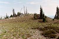 Broad summit area
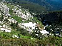 North basin
 On the north ridge
Big Fog Mountain is the southernmost of the greater than 7,000 foot mountains in the Selway Crags, a small local range of the Selway Bitterroots. These highly sculpted jumbles and precipices of Idaho Batholith granite occupy the divide between the Lochsa and Selway canyons in the Clearwater Basin of north central Idaho. At 7,122 feet it is not among the highest summits in the group, but it has several features making it an interesting and worthwhile mountain to visit. In about three horizontal miles it rises over 5,300 feet over the lush warm cedar forests of the Selway River in the western end of the extensive Selway Bitterroot Mountains. It forms a triple divide between Gedney Creek, the West Fork of Three Links Creek and face drainages of the Selway. It has 327 feet of prominence. The placement of the mountain on the edge of the deeper drops into the Selway Canyon gives spectacular and expansive views of the massive gouge in the earth carpeted with dense green inland rainforests thousands of feet below.
The summit forms a large, broad dome shaped pyramid that is very different in character to most of the topographic features in the area. Snow seems to persist here very late and the east and north brims often hold very large snow brows late in the summer or even year long. This is likely due to the funneling of weather from the canyon directly to the west and the shape of the mountain prevents snow from dropping off the upper elevation. The deep soil development is unusual for this elevation, which is probably another feature of the shape. This results in an interesting vegetative community including a very open and stunted subalpine forest dominated by low evergreen shrubs and high elevation forbs, some of which are rare. The east and north aspects support small cirques that contain ponds and subalpine wetlands. The walls of these cirques are formed by very rugged granite.
The mountain is heavily visited primarily because of its close proximity to the Big Fog Saddle, which is the primary eastern trailhead to the Crags. This is especially true during hunting season when several outfitters work the area. Wearing orange and traveling in groups is advised during that time. While the mountain is rarely a destination in itself, it is traversed by almost everyone entering the east portion of the Crags.
Getting There
 Big Fog Saddle
 Trail near the summit
There is really only one way to get to this mountain. It’s a short hike of just less than two miles from the Big Fog Saddle trailhead on trails 343 and 363. To reach this trailhead travel up the Selway River from Highway 12 at Lowell almost to Selway Falls. This is about 18 miles. The first several miles are paved, but most of the road is gravel. Some places are narrow and traffic can be heavy at times so watch the corners. Just before Selway Falls, take a left up the Fog Mountain road (Forest Service road 319). This road is well signed. From the Selway River the trailhead at road’s end is thirteen miles. The first half of this road is narrow, but in fair condition. The second half of the road gets progressively rough with large jutted rocks and seasonal streamlets breaking up the surface. A high clearance vehicle is advisable. The thirteen miles likely will take over an hour.
Once at the trailhead take the 343 trail to the east. This trail climbs fairly steeply before leveling off on the ridge and giving tremendous views of the Canteen Creek basin and the central Crags beyond. Soon the trail drops into a saddle before rising up the broad summit dome of Big Fog Mountain. Just before the top the trail will split with 343 going east and 363 continuing over the summit and the ridge beyond.
Red Tape
None, other than standard wilderness regulations.Camping
 Big Fog Lake
There really are not any applicable areas to camp for a hike to the top of this mountain. It’s very close to the trailhead, which does provide good camping. There are some ponds in the cirques north of the mountain. But this mountain is a stop along the way to more interesting places further into the Crags so one likely would not camp nearby. Most people hiking over Big Fog Mountain will go on to camp at Legend Lake, which is on the east side of the ridge about two miles further north. To reach this lake, stay on the trail. Soon the trail will vanish on the broad ridge top, but when the ridge narrows, the trail will reappear. Follow it down the east aspect. This trail is small and intermittent and will often be covered in snow. Follow it the best you can but be prepared to do some minor bush whacking to reach Legend Lake. Big Fog Lake is a little closer and the trail is more easily followed to that point.
There are 10 campgrounds and several good dispersed sites along the Selway River road between Highway 12 and Selway Falls for those arriving late who don’t want to navigate the 319 road or arrive at the trailhead in the dark.
When To Climb
The area receives huge amounts of snow and hiking to the summit before late July may be difficult some years. Late summer or early fall would be best, especially after the bugs have died off. However, trips later in the year have the increased likelihood of having the air heavy with smoke from free burning wilderness fires.Mountain Conditions and Information
 Ivesia tweedyi
 Anemone occidentalis
Go to the mountain prepared for variable conditions. With over a mile of vertical lift from the canyons of the Lochsa and Selway basins to the top of the Crags, mountain temperatures and weather conditions can vary dramatically. Many years the trails and slopes are open from snow by mid-July, but in heavy snow years some high ground may not lose snow until fall or not at all.
Contact the Moose Creek Ranger District of the Nez Perce National Forest for information and current conditions.
Moose Creek Ranger District/Fenn Ranger Station
831 Selway Road
Kooskia, ID 83539
(208) 926-4258
Office hours
Mon-Fri, 7:30 - 4:00
The north side of the Lochsa/Selway divide is on the Clearwater National Forest, Lochsa Ranger District.
Lochsa Ranger District/Kooskia Ranger Station
Route 1 Box 398
Kooskia, ID 83539
(208) 926-4274
NOAA Forecast