
-
 4205 Hits
-
 71.06% Score
-
 1 Votes
|
|
Route |
|---|---|
|
|
46.54400°N / 10.85890°E |
|
|
Hike and Scramble |
|
|
Half a day |
|
|
I |
|
|
Approach
Trailhead is the upper station of the skilift at Tarscher Alm / Malga di Tarres. You reach it by leaving Vinschgauer Staatsstrasse (SS38) at Laatsch / Laces and turning into the side road that leads up to and through Tarsch / Tarres. The road ends at the lower station of the ski lift which you can take to get up to Tarscher Alm / Malga di Tarres at 1900m.
Route Description
Alltitude difference: 1320m
Difficulty: I (ascent to Blaue Schneid, final ascent to Hasenöhrl)
Duration: 4h
Trailhead: Tarscher Alm / Malga di Tarres
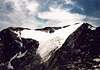
Always running along the southern flanks of Hasenöhrl and in a long section following a ridge this ascent offers great views towards the Ötztal Alps in the north as well as to the Sesvenna group to the west. A long patch of the ascent follows an old irrigation channel (called Waal locally) that had been built in 1868 to provide the orchards and vineyards on the Vinschgau valley floor with water. This Waal has in recent years been declared cultural monument.
The ascent starts from the ski region of Tarsch through Larch forests but mainly over meadows towards Tarscher Pass / Passo di Tarres. Here for the first time you can sneek a view to the sothwest into Ulental / Val Ultimo with its multiple reservoir lakes.
From the pass the trail follows the irrigation channel for some 3km always changing sides and sometimse running through the old Waal bed. At the end you reach an aquaeduct - now in ruins (see picture) - from where a couple of trails from Ultental and from Martelltal meet our trail. Here the ascent to the side summit of Blaue Schneid /Cresta Azzurra starts. It becomes a scramble of grade I, especially shortly before you reach the crest. There are differing altitude indications for the crest: 2915m on maps, 3000m on the cairn on its highest point.
After the crest turn upwards towards the ridge between the two glaciers (Kuppelwieser Ferner left (east), Hasenöhrlferner right (west)). The ridge becomes clearly sharper. The first upswing is circled to the right - secured by chains. Now follow the highest part of the ridge first in a scramble (I) which later turns int o a hike as the summit flattens. Enjoy the views towards Dolomites and Ötztal Alps.
 |  |  |  |
Essential Gear
Hiking gear is sufficient.