
|
|
Mountain/Rock |
|---|---|
|
|
44.47820°N / 115.2751°W |
|
|
Valley |
|
|
Hiking |
|
|
Spring, Summer, Fall, Winter |
|
|
8743 ft / 2665 m |
|
|
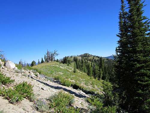
Closing on the summit of Blue Bunch Mountain

Splattski's snow visit
Overview
Blue Bunch Mountain has one of the strangest names I've run across. Blue Bunch? Actually, there is a wild grass known as Blue Bunch Wheatgrass and it is possible that there is enough of this on the mountain to warrant the strange sounding name.The attraction to some of us about this mountain is that it is the 65th most prominent peak in the state of Idaho, with over 2300 feet of prominence. By combining this mountain with nearby Cape Horn Mountain, a prominence peakbagger can enjoy two nice mountains that are close together.
The mountain still shows the effect of recent fires as there are several places where affected trees have fallen down across the trail requiring the hiker to step over them or find a way around them. Two curiosities are also found along the hike, one is a huge green watering trough that has you asking yourself how they got the thing up there and another is an abandoned shelter of a hermit who once lived on the mountain back in the 70's.
Getting There
Trailhead
Easy to get to, this one has a trailhead that is only 12 miles from highway 21 and is accessed by the road that goes over Cape Horn Mountain pass. A regular passenger car can make the 12 miles to the trailhead if driven carefully and the gravel road doesn't require high clearance or 4 WD.
From Boise:
Head up Idaho highway 21 through Lowman and on to Banner Summit. A few miles past Banner Summit, turn left onto the signed Boundary Creek/Landmark/Deadwood Reservoir road. Follow this good gravel road for about 3 miles to Capehorn Summit at 7,200 feet. The trailhead is at the pass on the north side of the road and there is adequate parking on the other side.
From Stanley, take highway out of town and go about 21 miles west, watch for the turnoff mentioned above and turn right on the signed gravel road to the pass that is located 3 miles from that turnoff. If you pass the Banner Creek Rest area, you have gone just a bit too far.

Red Tape
This mountain is located in the River of No Return Wilderness area and is subject to the wilderness restrictions. No motor vehicles or mountain bikes are allowed so you aren't going to be able to drive your car to the top of this one. A decent trail will help you get there however. For more information:Lowman Ranger District
7359 Highway 21
Lowman, ID 83637
(208) 259-3361
Office hours: 8:00 am - 4:30 pm Monday-Friday
Camping
Fir Creek Campground is very close to the trailhead. It has eight spots with tables, firepits and a nice vault toilet facility. You could also car camp at the trailhead or find a spot in the nearby area.
Fir Creek Campground
Dennis Poulin's trip report
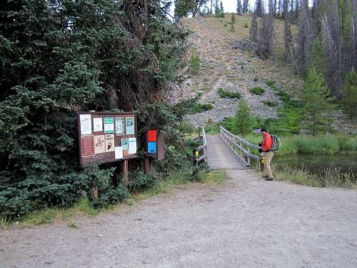
Dennis Poulin and I spent 12 days together in Idaho and Nevada and in that time Dennis became only the 4th person to complete all of Idaho's 44 county highpoints. The last person to accomplish that feat was IdahoSummit's very own Dan Robbins. Dennis put together this valuable information and placed it at peakbagger.com along with his GPS track which a person can download."We approached Blue Bunch Mtn from Hwy 75. About 21 miles west of Stanley we turned right on a nice gravel road signed for Boundary Creek. Zero your odometer and go 8.0 miles and turn right on road 579A that is signed for Blue Bunch Trailhead. Follow this road past the campground to where it ends at 8.4 miles. There is a nice bridge across the river for foot traffic.
We car camped in the campground and the next morning drove to the trailhead and started our hike. Once across the bridge turn left. We walked back and forth along the fisherman trail near the river looking for the trail that goes up the hill towards Blue Bunch. We finally just gave up and climbed the hill until we intercepted the climbing trail. The trail was hidden by grass and wildflowers. It is about 100 yds west of the bridge and goes up a little drainage before turning and climbing the hill. Once we found the trail, it was easy to follow up to the area near Cy Springs where it again gets lost in grass and wildflowers. We just continued up the slope towards the summit until we intercepted teh trail again. It is nice and open on the ridge and as long as you keep going north, you won't get lost.
Nice views from the summit and this is a nice hike."
Weather
Stanley IdahoI should mention that mornings dropped into the 20's during our visit in mid August.
The hike & the summit
Mostly a trail all the way to the summit that was close to 9 miles roundtrip and sported close to 2500' of elevation gains (including the ups and downs).Quite a few trees down across the trail but all were easily circumvented. There was one area above Cy Springs where the trail fades for a short distance but is easily picked back up as one gains the ridge area.
We found a cairn and a register at the high point.

The summit & cairn
 Page 1
 |  Page 2
 |  Page 3
 |