July 27, 2007: Road Trip From Western Washington
I had been planning to climb Borah Peak (also known as Mount Borah), Idaho's highest point at 12662' elevation, for several months but had been waiting for a good opportunity to do the trip. I wanted to wait for the snow on the mountain to melt, and I had been busy each weekend during June & July. However, this particular weekend finally presented the optimum scenario: No plans (me), a trustworthy, willing, & available hiking partner (Adam), and (fortunately, but out of our control) good weather conditions predicted for the day of the climb (Saturday).
Although I had recently summited both Mount Rainier and Mount Whitney in the weeks leading up to this weekend, Borah Peak was to present new challenges for my mountaineering & highpoint adventures. I knew that the main challenge for me, at least for one day, was to try to overcome my concerns with scrambling, which is basically rock climbing without the need for a rope. Don't get me wrong, I don't have a fear of climbing but I do have a fear of falling off of cliffs. Of state highpoints, Borah Peak is widely considered the sixth-most difficult highpoint to summit, with several sections of Class-3 scrambles (i.e. difficult high-angle rocky cliffs where handholds & footholds are plentiful). As an additional challenge, neither Adam nor I had any experience with scrambling. In fact, Adam had never gone on a hike higher than 6500' elevation before. However, having been close friends for many years, at least we both knew that we could trust and help each other during the trip.
On Friday, July 27, I had already requested the day off from work in anticipation of this trip. Adam spent Thursday night at our house and we left at 7:00 AM on Friday morning. Borah Peak is approximately 11-12 hours away (non-stop) from our house, and it turned out to be a 1430-mile roundtrip road trip. The trip's speed limits were rarely below 65 MPH, which was great for us. In fact, my car had its best fuel economy, to date, during this trip, at an estimated 38-40 GPH average usage. During the drive from our house, we basically only stopped for gas and meals. We had lunch at "CJ's Coffee & Cafe" in Kellogg, Idaho, and it was very good food at a good price. We had dinner at a "Subway" in Salmon, Idaho, after spending several hours driving through western Montana before heading back south through Idaho.
![Bighorn Sheep]() Bighorn Sheep
Bighorn Sheep
Between Salmon & Challis, Idaho, the closest town to Borah Peak (but still 36+ miles away from the trailhead), we had two interesting stops. First, we stopped at a sign that said "Crossing the 45th Parallel: Halfway Between The Equator And The North Pole". We thought that sign was pretty cool. The second interesting stop was a mountain goat standing next to the road. Within a half-mile from seeing that animal was a sign, pointing to another road, that read "Wildlife Viewing Area". As we passed by that road, we looked over to it and noticed a gigantic herd of Bighorn sheep covering the road. We laughed that the sign was remarkably correct. We finally arrived in Challis at 9:30 PM (MST), and quickly found a hotel with vacancies, although we had a tent & sleeping bags as a contingency plan just in case no rooms were available anywhere in town. Unlike the nights prior to my Mount Rainier & Mount Whitney summit climbs, I was actually going to get more than a few hours of sleep. I welcomed a good night's sleep.
July 28: A Chicken Out Ascent Route
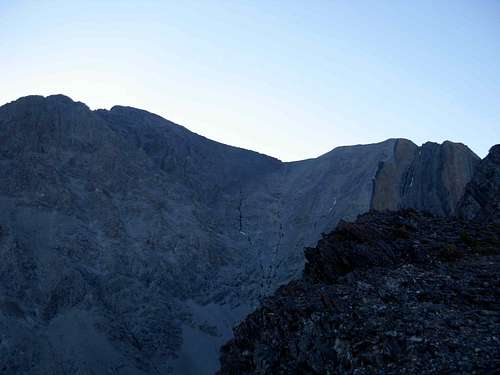
![A View Of Borah Peak]() Borah At Sunrise
Borah At Sunrise
Adam & I woke up early, leaving Challis at 5:00 AM and arriving at the trailhead shortly after 5:30 AM. On the way there, we saw numerous deer on the sides of the road as well as one porcupine crossing the middle of one road. We parked near the trailhead and quickly noticed that quite a few people had camped overnight. My car was next to a car containing a group of four young 20-somethings (two guys, two girls) from Boise. They were getting their backpacks ready for the hike at the same time as us, but we left before them. Adam shared some of his Rainier cherries with them, which none of them had eaten before but all of them instantly loved. A lot of people around the parking lot/ camping area looked like they were preparing for the hike, and we heard that several had already left. In fact, one person told us that he had heard that one group left at 2:00 AM so that they could watch the sunrise from the summit.
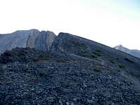
![The First Ridgeline]() Following The Ridgeline...
Following The Ridgeline...
We began our hike at 5:45 AM, and the weather conditions were great. The trip to the summit is "only" 3.5 miles (one-way), but the average elevation gain is over 1500' per mile (which is quite rigorous). The first section of the hike was a jaunt through a pine forest. The forested section of the hike soon became very steep, and we knew that the descent might be tough as a result. We passed several groups along this stretch, pulling ahead of all of the groups that left after 5:00 AM. Just beyond the treeline, at approximately 10000' elevation, we reached the top of a long ridge. One side of this ridge was a straight-down vertical drop, while the other side (containing the trail) was diagonally slanted.
The end of the first ridge marked the beginning of a steep, shale & scree covered, ridgeline, known as "Chicken Out Ridge". It received this name by being the notable place that hikers decide to turn around, due to the scrambling that is necessary to cross it. Actually, when we reached the base of this section, one group of men was climbing off of it after "chickening out". Adam & I climbed up the first scramble wall without too much difficulty, but then got stopped at the next section of the ridge.
![One View from Chicken Out]() A View From "Chicken Out" Ridge
A View From "Chicken Out" Ridge
We ended up at a point where we could go up or down, and we spent a long time contemplating every handhold & foothold. It was at this point that Adam briefly considered turning around. Noticing one guy climbing at another part of this steep incline, and making it look easy while he was doing it, we climbed down to where he went. While we were doing so, the group of four that parked next to us ended up at the same point of the ridge as we had, and proceeded to make climbing (both literally & figuratively) along the top of the ridgeline look easy. We all stopped at a small, flat, midpoint section, and then Adam & I climbed with their group the rest of the way to the summit. The next part of "Chicken Out Ridge" contained an even steeper, nearly vertical rock wall to climb, as well as a loose dirt & scree incline to traverse. When we finally reached the end of "Chicken Out Ridge", we each had senses of relief and accomplishment.
![Looking At The Final Climb]() Looking At The Final Climb...
Looking At The Final Climb...
The next stretch of the hike was fairly flat and walkable, winding around a hill, with a small patch of snow at one edge of it. This marked the beginning of the final stage of the summit-climb, a 800' scramble (but more walkable than "Chicken Out Ridge") of extremely loose shale & scree. During both the ascent & descent of this section, several large pieces of rock slid down the hillside towards us, accidentally caused by hikers above. During this section, Adam was really starting to feel very dizzy, a definite indicator of altitude sickness, and I told him that we could take as much time as he wanted, even turn around if needed, but he told me several times that the more he stopped the more that his head would hurt. With the summit only a very short distance from us, he was looking forward to resting his throbbing head on the rocky mountaintop.
![Successful Summit Climb!!!]() Summit Pose
Summit Pose
I took a short water break about 25 feet below the summit, but Adam proceeded. When I reached the summit, I saw Adam sitting on a rock. He said that he was not feeling well, stood up, bent over, and then puked. And then puked again. And then again a third time. One of the guys at the summit yelled, "Way to go… Chunks!" I told them that "Chunk" isn't just a member of the Goonies, anymore. We were only at the summit for about 10-15 minutes, during which time several photos were taken. I signed the summit register, which was just a clump of random papers inside a metal box, but Adam had no desire to sign anything. He said that his puke was a "badge of honor" enough.
July 28 & July 29: The Descent And Return-Trip
I told Adam that his head & body would likely feel relief as soon as he started descending, and I was correct. We stopped to talk with nearly every person we encountered, even giving advice & assistance to several ascending climbers. The descent did not take as long as the ascent, but the downward hike was most brutal on the legs & feet during the steep forested section. I had found a hiking stick hanging over "Chicken Out Ridge" during the descent, and I believe that greatly assisted my efforts. With that said, each of my big toes tremendously hurt from the steep descent. I had read that most successful Borah Peak summit-climbers usually take 10-12 hours to complete the hike, roundtrip, not including the time spent at the summit. Our hike took less than 9 hours total, including the times we stopped at the summit, helped people, and talked to people, so we were really satisfied overall, especially considering that we were both first-time scramblers. We both wanted to enjoy the hike as much as possible, and our non-aggressive ascent pace helped Adam from getting sicker than he may have otherwise become. However, it looks like Adam will be a one-time scrambler, as he vowed to never again hike above 10000' elevation because he does not ever want to have altitude sickness again. I thanked him for going, and congratulated him for accomplishing the summit-climb; I was really proud of him. And for me, personally, I was ecstatic to have successfully summited three difficult State Highpoints (Rainier, Whitney, Borah)... my first-ever State Highpoints summited... without guides and on first attempts.
We drove non-stop to Missoula, Montana, which is a very large city, hoping to find hotel vacancies. We went to every hotel, and the only room available... yes, I said the ONLY room available in the entire city... was a single-bed hotel room at a "Best Western" that cost $149. Perhaps needless to say, the option was not worth pursuing. The hotel concierges told us that Missoula is like this every weekend during the summertime. I wish that we had gotten the memo! Even the restaurants were packed, so our choices for dinner were limited. I told Adam that we could reach Coeur d'Alene, Idaho, in approximately two hours, and that there should be plenty of hotels and restaurants there, and he said that we should try doing that. My time estimation was correct, and we ate at "Applebee's" in Coeur d'Alene. However, Adam wanted us to save money by making several stops at rest areas rather than finding a hotel room. We made four stops between Coeur d'Alene & home: two stops at rest areas for long naps, one stop at Moses Lake for a gasoline fill-up (and for Adam to get coffee at "Starbucks"), and one very brief stop at "Indian John Hill" Rest Area. We finally arrived home during the day on Sunday, completing a long road trip that transpired in a short amount of time. I was exhausted, my big toes each hurt, and my legs were stiff. After such a difficult hike and long road trip, the rest at home was well worth it.


Comments
Post a Comment