
-
 41289 Hits
-
 73.06% Score
-
 3 Votes
|
|
Area/Range |
|---|---|
|
|
22.42626°S / 44.84379°W |
|
|
Hiking, Mountaineering, Sport Climbing, Toprope, Bouldering, Big Wall, Mixed, Scrambling, Via Ferrata |
|
|
Spring, Summer, Fall, Winter |
|
|
9177 ft / 2797 m |
|
|
Overview
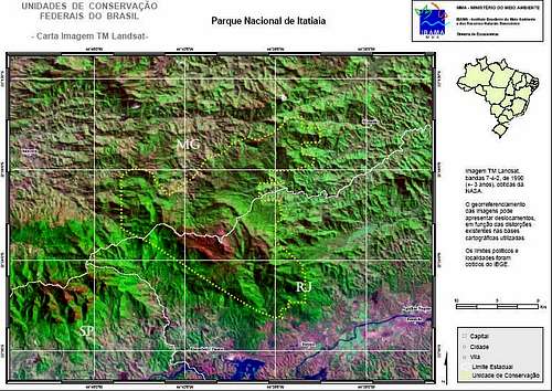
The Brazilian Highlands rises farther inland to the west, where the states of Rio de Janeiro and São Paulo meet the State of Minas Gerais, and continues from west-south-west to the north-east in Minas Gerais. In Rio de Janeiro this mountain range often is very dissected, having its more accentuated topography in the south, where the peaks of Itatiaia reach nearly 2800m.
The Mantiqueira Mountains ( In Portuguese "Serra Da Mantiqueira") is a mountain range of eastern Brazil, rising abruptly from the northwestern bank of the Paraíba do Sul River and extending northeastward for approximately 320 km, reaching a height of 2,797m in the Pedra da Mina. There are several peaks above 2000m and, a lot of them very pointed and peaky.
The mountains, which eventually merge with the Serra do Espinhaço, were originally forest-covered except for the peaks that rise above the tree line. They provide charcoal and pasture for cattle; on the lower slopes there are several health resorts, including Campos do Jordão town, the higher city in Brazil, at 1800m.
The name Mantiqueira derives from a Tupi-guarani Indian word meaning “mountains that cry", thus called because of the large number of springs and streams found on their slopes
The Mantiqueira is a popular region for mountain climbers and trekkers, where in the winter, which is the dry season, one can climb some of the highest peaks in the country:
Pedra da Mina – 2,797m
Agulhas Negras – 2,791m
Pico Três Estados – 2,665m
Pico dos Marins – 2,421m
Getting There
The area of Brazilian Highlands is large and it’s impossible to write here all the access to climb the mountains, so the MSN Mappoint could help the people that will be there someday. Mantiqueira localizes between the two biggest cities in Brazil, Rio de Janeiro and São Paulo. If you drive by BR-116 called Via Dutra Highway, it is possible to see all these peaks mentioned.
MSN Mappoint - Brazilian Highlands
Ecosystem
The Serra da Mantiqueira integrates the ecosystem of the Mata Atlântica (Atlantic rainforest) which has one of the greatest biodiversities of Brazil. Despite the occupation of the lands for livestock raising, there are still regions of well-preserved forest where we find an impressive variety of trees like the jacarandá, cedro, canjerana, guatambu, ipês, canela, angico, jequitibá, and also the araucária (or Brazilian pine) and pinheiro-bravo (wild pine), typical of tropical climates of elevation.
This is also the habitat of a varied fauna where we can still find the veado campeiro, the guará wolf, the brown onça ( pumas ), the cachorro-vinagre, the jaguatirica, the paca, the bugio monkey, the sauá monkey, the squirrel, and the hedgehog.
Among birds we can distinguish the gralha-azul, the toucan, the maitaca, the inhambu, the jaçanã, the seriema and the gavião carcará. All of this in a region whose closest point is only 100 km from the city of São Paulo and, 200 km from Rio de Janeiro.
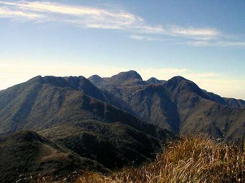
Mantiqueira Main Summits
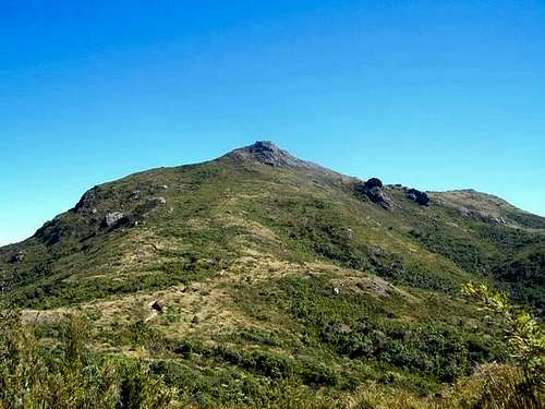
Pedra da Mina 2797m
Pedra da Mina – 2797m
The highpoint in Mantiqueira range is Pedra da Mina. The trail to reach the summit is very hard but, the difficult make it pleasure.
Pedra da Mina
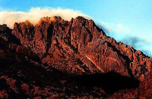
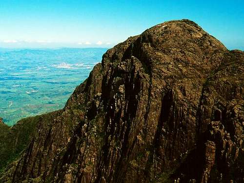
Agulhas Negras 2791m
A few years ago, before these technologies, this was the higher mountain in Mantiqueira Range but, today, GPS and other equipment, accurate the right altitude – 2791m. This is the main mountain in Mantiqueira Range. More than 2000 people visit this mountain every year.
Agulhas Negras
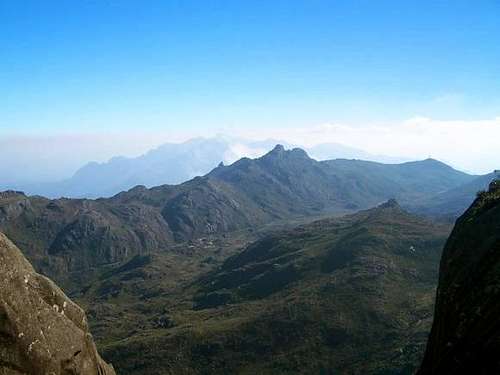
Pico do Couto 2680m
This is the best place in Itatiaia National Park to see from a distance the highest mountain in Mantiqueira - Pedra da Mina.
Pico do Couto – 2680m
Pico do Couto
Pedra Furada 2498m
Pedra Furada – 2498m
Pedra Furada
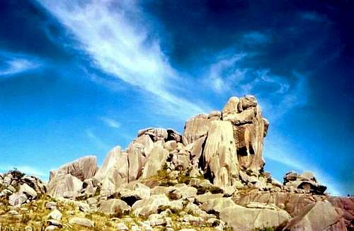
Prateleiras 2548m
One of the most impressive rock formations in Mantiqueira Range, rises 2548m above Sea level.
Prateleiras
Pico dos Marins 2421m and Itaguaré Peak 2308m
Another great group in Mantiqueira. Very popular and have an easy trail to the summit. Itaguaré is a high difficult peak to climb, because the access is from the trail to Marins and is very far from this one. But the mountain is very beautiful.
Pico dos Marins
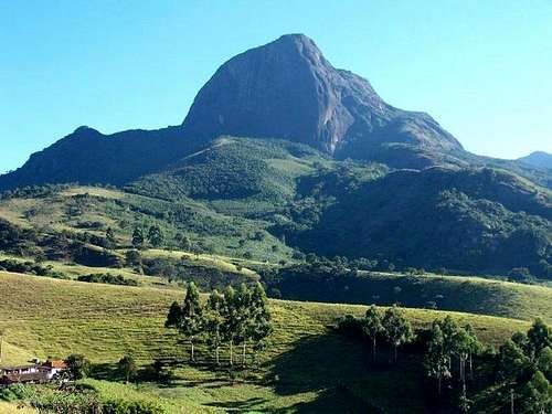
Pico do Papagaio 2293m
Emerging from Vale do Matutu, Pico do Papagaio is an important mountain at Mantiqueira Range . Pico do Papagaio is in the north portion of Brazilian Highlands.
Another great range is near from Papagaio - Ibitipoca mountains, in Parque Estadual do Ibitipoca - MG ( Ibitipoca State Park )
Ibitipoca - Brazilian Scenes
Ibitipoca - Trek Earth
Pico do Papagaio
Weather
Due to the altitude, the winter in the Serra da Mantiqueira sees low temperatures, with the occurrence of fog in the beginning of the morning and not infrequent frost, giving the landscape the appearance of regions of cold climate. It is common for the thermometer to reach temperatures near 0ºC, while in the highest cities like Campos do Jordão and Monte Verde there have been temperatures of - 5ºC in recent years. On the highest peaks, the cold can be more intense and the temperatures can drop to -15ºC.
Weather
Camping
Almost all peaks proportionate a good area to camp near your summits. I advise checking the mountains page to see the correct places to camp at Mantiqueira Range.