
-
 10384 Hits
-
 91.14% Score
-
 34 Votes
|
|
Mountain/Rock |
|---|---|
|
|
44.32990°N / 115.2869°W |
|
|
Boise & Custer |
|
|
Hiking, Skiing |
|
|
Spring, Summer, Fall, Winter |
|
|
8876 ft / 2705 m |
|
|
Overview
Bull Trout Point is located on the southeast edge of the vast Salmon River Mountains of central Idaho, not far from the northern portion of the Sawtooth Range. It is the highpoint of a mostly east-west trending ridge that begins at the Bull Trout Lake area east of the peak, and extends all the way to Bear Valley in the west. The most impressive feature of the mountain is the north face of the east ridge, with steep cliffs and chutes dropping several hundred feet below. That section of ridge is just over a mile long, and is labeled on some maps as “Mains Ridge”. The southern slopes are much gentler, with stands of Lodgepole Pine around the base, which open up to provide better views for the last 1500 feet or so to the summit. A forest fire burned much of the trees southwest of the summit within the last decade or so, which provides for some varied scenery.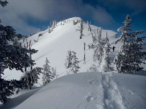 Final Summit Approach
With a very respectable prominence of 1556 feet from the saddle at Cape Horn Summit, Bull Trout Point is a good vantage point for checking out the surrounding mountain ranges. The most distinctive nearby peaks are Cape Horn Mountain to the north, Copper Mountain to the east, and Red Mountain to the south. Bull Trout Point also provides views into three adjacent counties, since the summit is located on the dividing line between Boise County and Custer County, and is only about three-quarters of a mile from the Valley County line to the northwest. The peak is also located on the national forest boundary that separates the Boise National Forest from the Salmon-Challis National Forest. (This concludes the useless trivia section.)
 Along the east ridge.
Getting There
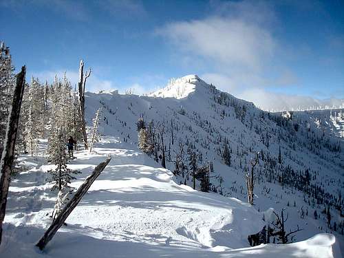
 East Ridge Route
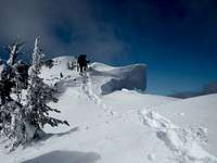 Cornice Crossing
 Snowshoeing
 North Face
The Drive – From Boise, follow Highway 21 through Idaho City and Lowman, then past the Grandjean turnoff and Banner Summit. At 1.2 miles north of Banner Summit, turn west on the road (FS520) for Bull Trout Lake. This would be about 24 miles from Stanley if coming from the opposite direction, about halfway between mile-markers 107 & 108. In winter, the road may not be visible, but there is a pullout on the west side of the highway that is kept plowed. Plan on 2+ hours of driving time from Boise, allow for even more time during winter.
Avalanches – The section of highway from Grandjean to Banner Summit is probably the most heavily avalanched stretch of road in all of Idaho. It is closed frequently in winter, and often with very short notice. Make sure to check the road conditions for Highway 21 before heading out.
The Hike – The east ridge is the most likely approach option. From the highway, hike about a quarter mile to the sign for the “Bench Creek Trail”, then turn right and head northwest at the sign. (You can drive to this point during summer months.) From here, weave through the stands of Lodgepole Pine trees for another half mile, then begin climbing the east ridge. You’ll want to tend towards to the south side of the ridge, away from the steep north facing cliffs, which are pretty heavily corniced in winter. The first false summit is about a mile from the base of the peak. From there, continue another mile-and-a-half along the ridge to the highpoint, crossing a couple more false summits along the way. The hike could be made into a small loop by following the southeast ridge back to the starting point. Numerous other route options would be feasible in summer months, but with longer approaches.
Its about 3.4 miles one-way, and 1950 feet of elevation gain from the highway to the summit for the east ridge route.
Camping
There are numerous camping opportunities nearby. The natural choice would be the popular Bull Trout Lake Campground, where some sites are reserveable. If that one is full, there are also a few first-come-first-serve campgrounds along highway 21. The closest ones to the trailhead are at Bench Creek and Banner Creek.When to Climb
Bull Trout Point can be climbed throughout the year thanks to a close proximity to Highway 21. A snow-free climb can be made from some time in June until the snow flies in October. A winter ascent is very doable along the east ridge where avalanche danger is pretty moderate for those familiar with assessing the conditions.Mountain Conditions
- Boise National Forest - NF Current Conditions.
- Salmon-Challis National Forest - NF Current Conditions.
- Sawtooth National Forest Avalanche Center - Current Avalanche Conditions.
- Banner Summit SNOTEL – Weather conditions from the nearest SNOTEL site.
- NOAA Forecast – Pinpoint Weather.
- Idaho Outdoors Forum – Message board monitored by many local climbers.