
|
|
Mountain/Rock |
|---|---|
|
|
38.34160°N / 105.891°W |
|
|
13105 ft / 3994 m |
|
|
Overview
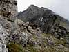
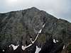
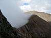
Bushnell Peak is the Fremont County High point. It straddles the Saguache and Fremont county line at the far northern end of the Sangre de Cristo mountain range. Fremont County is also the home of the Royal Gorge and Canon City. Bushnell's west side is a steep, unrelenting slope, an avalanche zone in winter. The east side is characterized by interesting ridges and high lakes.
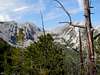
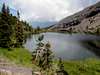
Bushnell Peak is impressive looking by itself, and varied in color. Bushnell Lakes and waterfalls add even more interest for fishermen, and beauty for all visitors who approach this mountain on the east side. A well developed trail system will lead you up to the lakes from several directions. Bushnell Peak is infrequently climbed, owing to the rather long and tedious approach that is required. The west approach is shorter but has little else to recommend it.
 |  |  |
Getting There
There are two main approaches: Bushnell Lakes from the Wet Mountain Valley side, and Brook Creek from the San Luis Valley side.
Hayden Creek Campground: Elev. 7740 ft. Provides access to Bushnell Lakes Trailhead, and the east side of Bushnell Peak, via a good trail system. Turn off U.S. highway 50 at Coaldale onto a road that is marked for National Forest access. Drive 5 miles west on this road to Hayden Creek Campground . Pass the Coaldale Campground and Rainbow Trail access point on the way. The road is good all the way to the campground.
Brook Creek trailhead: From Villa Grove, drive 0.7 miles north on U.S. 285 and veer to the right on CR 57. Turn right after 4.4 miles at the T intersection. Follow FR 985 into the Brook Creek drainage.
 |
Red Tape
Day use parking costs $4 at the Hayden Creek campground. There is no free parking in the campground. There is room to park one vehicle at the base of Hayden Pass, which is right next to the campground.
Signs emphatically prohibit ATVs and other motorized vehicles on these trails. Also, forest restoration projects are in progress.
Routes Overview
Northwest Ridge: A long, scenic hike on the east side of the mountain, followed by a rocky ridge climb. Minimum 5365' elevation gain and 13 miles round trip.
West Slopes: unrelenting climb on old jeep road and finishing on steep scree slope and rocky ridge. 4735' elevation gain, 8.5 miles round trip. See Mitchler and Covill's Hiking Colorado's Summits for detailed route information.
 |  |
Camping
Hayden Creek Campground is located at the trailhead on the east side. The Coaldale campground is just a miles lower. In additional, there are several single campsites along the road to Hayden Creek Campground. Hayden Creek Campground gets heavy use on weekends.
Primitive camping is also allowed in the forest with certain restrictions. There are a couple of nice campsites by the lower Bushnell Lake, if you wish to pack in.
Mountain Conditions / When to Climb
Current, local conditions are maintained by the Forest Service at their web site. Besides the current weather, they publish campground status, road conditions, trail status, and closures.
The summer months are the best time to climb mountains in the Sangre de Cristos. Be aware of the high potential for lightning on summer afternoons. Thunder and hail cut my day short on Bushnell and Twin Sisters. See photos. The danger of avalanches here is high in the winter. Use good judgment, and Check the Weather Forecast before you go.
 |  |