Driving Directions
To start our hike, my wife and I parked approximately 2 miles past (east of) Snow Valley Ski area, on the west side of the roadway along Highway 18 in the San Bernardino Mountains. The parking location is described as a dirt pull-out which narrows to a forest access road leading off to the west, contouring along the mountain face. Usually the a gate blocks the road, approximately 100' back from the highway.
This is the place to park. Notice the CalTrans yard and service loop on the opposite side of the road, this is easy to see coming from the East...but back over your shoulder coming from the west, as most of you will.Not for the weak!
The route we took should be a well established trail in a book titled "100 best hikes of So Cal..." or something like that! Instead, it is currently a cross-country route up and across one of the more spectacular ridge lines in Southern California. While the ridge line itself is quite moderate, the north and south faces of the ridge are very steep, and you have to ascend some of the steeper terrain to gain the moderate ridge line. Once upon the ridge top, you can feel rather exposed (by hiking standards) in places as the face drops well over 3000 feet to canyon bottoms below (Bear Creek) to the south, and a maze of canyon systems to the north (Holcomb Creek Drainage). While the hike is demanding due to a lack of maintained trail and exposure to elements, views along this route are rewarding! They include long range views the Los Angeles basin, the jagged San Gabriel Range, the San Bernardino range spine toward the west, and the San Bernardino High Points including San Bernardino Peak, Mt. San Gorgonio, and Sugarloaf Mountain to the south east and east, as well as views across the Mojave Desert. In fact, the trained eye can locate Telescope Peak and Olancha Peak in the clearest days. The route involves approximately 2200 feet total vertical gain and is approximately 10 miles round trip. Your individual variation...will vary!
The entire route is within the mid-altitudes of the San Bernardino Range, starting at slightly over 7,000 ft, and ending at Butler Peak, 8,539 ft. Bring plenty of water as there is not reliable natural sources of water outside of the snow pack melting out. Additionally, I recommend a pair of trekking poles.
Be prepared to see deer, bobcat, mt. lion, and perhaps a rattle snake if you vary off the course too much to where springs bubble out the sides of the mountain.
The route
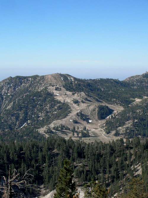
![Early Vantage of Snow Valley Resort]() From "Alison Point" you can see most of Snow Valley Mountain Resort.
From "Alison Point" you can see most of Snow Valley Mountain Resort.
From the parking location, ascend immediately up a path that appears to be an old fire break. Right from the start, the route is steep and will test your patience. As you ascend, you will view hwy 18 from increasingly lofty heights to your right (east). Stay on the ridge line as much as possible, which will lead you to your first landmark, a radio repeater antenna after about 1/4 of a mile.
From here, stay close to the abrupt ridge line from which Big Bear Lake is visible and Hwy 18 is decreasingly audible. There is a more recent firebreak from the fires of 2007. The firebreak was well cut, then after the fire, the break was 'deconstructed' to a degree to restore the natural setting and prevent would-be offroad trails. The fire did not affect this area too dramatically, though signs of it will be discovered.
Staying close to the ridge line and pushing on for another 1/2 mile up steep terrain, you will find yourself upon the top of an exposed false summit unoffically dubbed "Alison Point" (elev. 7,860). There are some rock formations near the summit (just off to the west) which make for a nice breather location. The views of the bulk of the Butler Peak Traverse are good from this vantage point, being able to see the next mountain face that has to be ascended, as well as the ridge line that leads toward Butler Peak. To this point, the route has moderate forest canopy coverage of pines and a few oaks.
From Alison Point, descend about 100' and gain the mountain face immediately northward, bearing ever so slightly eastward without dropping over the abrupt drops to the east and south. Eventually you pick up the perimeter trail used to contain the fires in 2007. Using that trail at times, and bearing eastward as mentioned, you will eventually come to a rock formation marking the end of the steepest portion of this segment.
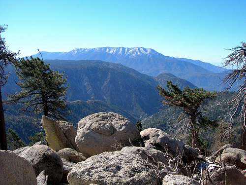
![Quiet and Solitary]() Beyond Alison Point, many natural frames offer great views of the San G. Wilderness!
Beyond Alison Point, many natural frames offer great views of the San G. Wilderness!
Follow the ridge line northeast and eventually mostly eastward. The ridge undulates a bit, with some minor descending to be followed by more ascending. Some of these low points are very quiet and tranquil. You will find several old roads and trails that are not necessarily maintained. Mostly ignore those roads as they will not ultimately lead you to your goal. Some of the roads do provide the benefit of easier travel.
After about 1.75 miles, you can feel okay staying more on the south face of the ridge as opposed to being directly on the ridge. Stay on the south face passing just under and south of Craft's Peak (8,353 ft). Contour along the south face (not too steep at this location) until intersecting the ridgeline, which is descending toward the east to a saddle between Craft's Peak and Butler Peak. (Craft's Peak offers little more than Butler Peak, unless you're just in the mood to bag peaks, in which case know that Craft's Peak will offer somewhat better west-ward oriented views, as well as a nice close up shot of Butler Peak.) Descend to the lowest point of the saddle where you will find some boggy low points, even swampy conditions in spring or early summer...just circumvent around the outside. We continued eastward and were surprised by the 2 or 3 false summits. We took a couple of breaks under some trees that survived the fires on the south face barely below the ridge line. The rather faint highway noises rising from below gently reminded us that we had in fact gained a good deal of altitude. Since you can't see the highway for the most part, you really get a sense of the steepness of the south faces of the Butler Crest. The ultimate summit lies beyond several false summits as you traverse the ridge. Traveling the south side of the crest we occasionally crossed gullies plunging about 1200 feet.
![Butler Peak Cross Country]() One of many odd rock formations along the way...
One of many odd rock formations along the way...
If you stay to the north, there will be occasional forest cover, less long-view possibilities, but equally steep gullies in places. The going is a bit tougher too.
Overall, the ridge line is exposed and relatively devoid of forest canopy, probably due to extreme wind/weather, and recent fires that took what was left. From what I understand, USFS has instituted tree plantings in the area, though I don't know about the ridgeline.
The final ascent to the actual summit is known by it's boulder-strewn western shoulder which requires moderate balancing skills, and slows the forward progress of most hikers, and then you will also see the fire lookout structure. Enjoy the views from the lookout tower or from the exposed outcroppings. To the south, these outcroppings drop quite a distance before intersecting with continuous steep terrain that plunges to Hwy 18 and Bear Creek Canyon beyond. Reverse your steps to return safely to the parking place where you started.
Comments
No comments posted yet.