
-
 19736 Hits
-
 86.85% Score
-
 23 Votes
|
|
Mountain/Rock |
|---|---|
|
|
48.99970°N / 121.671°W |
|
|
7516 ft / 2291 m |
|
|
Overview
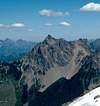
Sheer, high, and broken, Canadian Border Peak completes a high ridge in a spectacular alpine setting. Canadian Border peak is part of a group of 4 mountain that run North/South and include American Border Peak, Mt. Larrabee, and the Pleaides (all over 7,000ft). The peak sits just 0.4 miles North the USA/Canada border and is more prominent from Canada. Views of the Cheam Range, Mt. Slesse, Tomyhoi Peak, Chilliwack Valley, and North Cascades are trememendous. All approaches (except a South/North traverse) start in Canada.The mountain is composed of the highly fractured rock of the Chilliwack group, ancient sediments and volcanics, metamorphosed to phyllites, slates, and greenstones. The NW summit is the highest. Protection is difficult given the stregth of the rock, larger chocks and mid through large size cams work best but large slings and natural anchors are often most effective.
The most common route is the North RIdge route. Spring is the best time to climb while scree and talus slopes can be ascended on snow. Loose rock can be a problem here helmets mandatory. Approaches are aided by high logging road spurs but beyond that route-finding can be a challenge. Scree is unavoidable except in winter & early spring. Travel on steep meadows and heather can be trecherous, especially when wet. Any route will include exposure, Class 3 - 5.4ish climbing on sometimes marginal rock, gravely slabs, and steep snow as well (except very late season).
 |  |  |  |
Getting There
Slesse (Silesia) Creek Approach- Drive East on the Trans-Canada Hwy 1
- Take the Sardis Exit (Vedder Rd)
- Drive S to Vedder Crossing. Turn sharply LEFT (east) at the near side of the Chilliwack River Bridge
- After 12.6 miles (21.2km) take the Slesse Creek Rd
- After 3.7 miles a take the Right Fork toward to an army bridge and demolition area (keep hands and legs in the ride, road is sometime temporarily closed to practice blowing things up)
- Shortly after the bridge take the spur road heading SW up towards Canadian Border Peak. Drive as far as you can (the road may be in very poor shape), park (~4,000ft), and hike the remainder of the road.
Red Tape
No Permits. No FeesWhen To Climb
All year but best in Spring when snow covered slopes make travel easier. In winter there is a high Avalanche Hazard, prior avalanche safety experience required. Slopes are mainly E and N aspects. In spring wet slides can be a problem.Camping
Campsites are available below the NW ride on a large flat section of the lower shoulder, ~5.600ftMountain Conditions
Check Snow LevelCheck Avalanche Report
Check Weather Forecast
...More Info
Remember that these are general warnings and forecast, always use good judgement and retreat if necessary.
Necessary Gear
- Helmet
- Rope
- Slings (long)
- rock pro (larger chocks, cams, maybe pins)
- Ice Axe
- Crampons
Photo courtesy of member Just B. From center left (the jagged peak) to right is Mt. Slesse (B.C), Mt. McGuire (B.C) Canadian Border Peak (B.C), American Border Peak, Mt. Larrabee, Yellow Aster Butte, and Tomyhoi Peak.
rgb2 - Sep 6, 2010 1:50 am - Voted 9/10
BC FSR websiteOne issue in this area is the changing status and condition of forest service roads. I mean, what is written about the FSRs on this page may or may not be correct at any given time. For updates go to this site: http://www.for.gov.bc.ca/dck/Engineering/FSR_Conditions.htm