Monte Candelozzo is a summit of the Ligurian Apennine. The top, at 1036 meters, and the near
Monte Bano 1035 m, are the only mountains in this zone which exceed 1000 meters.
Three main ridges ( East, West , South ) sign the main path to climb Candelozzo.
All the northern face of mountain is covered with many trees as far as the top. Changing side, Candelozzo appears without vegetation.
Monte Candelozzo è una cima dell’Appennino Ligure. La vetta raggiunge i
1036 m e con il vicino monte Bano
1035 m, sono le uniche montagne in questa zona che superano i 1000 metri.
Tre creste principali ( Est, Ovest, Sud ) rappresentano i principali sentieri per scalare il Candelozzo.
Tutta la parete nord della montagna è coperta da una distesa di alberi fino alla cima. Cambiando versante il Candelozzo appare senza vegetazione.
Getting There
THE SOUTH RIDGE
The way starts at Capenardo
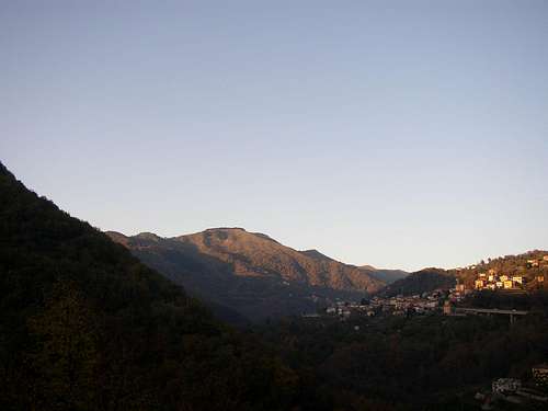
( 735 m ). Exit at Genova Est toolgate and follow the road signs to Molassana and Piacenza along Bisagno valley. The road runs beside the Bisagno river and after the boundary of Genova city makes some bends; follow the way at left to Davagna. The road climbs very quickly and after 2 km at another crossroad go left following towards the village of Marsiglia. The road is narrow (Pay attention!). When you arrive at the white road sign of Marsiglia, turn right. Continue the road as far as the little village of Capenardo because here starts the itinerary to climb Candelozzo South side
(see photo).
ITALIANO
LA CRESTA SUD
La strada inizia a Capenardo
(751 m). Uscire al casello di Genova Est e seguire i segnali stradali per Molassana e Piacenza lungo la vallata del Bisagno. La strada costeggia il fiume Bisagno e dopo il confine di Genova, dopo alcune curve seguire la strada a sinistra per Davagna. La strada s’inerpica molto velocemente e dopo 2 km un altro incrocio a sinistra seguendo per il paese di Marsiglia. La strada è stretta ( attenzione ). Quando vedete il cartello bianco del paese di Marsiglia, girate a destra. Continuate la strada fino alla piazzetta di Capenardo perché qui inizia l’itinerario per scalare il lato sud del Candelozzo.

Itinerary
THE SOUTH RIDGE ( Easy )
CAPENARDO
735 m - TOP OF CANDELOZZO
1036 m DIFFERENCE IN HEIGHT
301 m
The path is marked with one red square and the same path is marked with two vertical red lines, coming from Chiappaiolo near Davagna.
The climb is easy along the watershed. Along the path there is an electric enclosure at low voltage however troublesome if touched with hands, on the terrain ( attention ). Under our feet always short grass.
It’s always possible to see the top of Candelozzo, so this is a help for the hiker.
If you have information about EAST and WEST ridge you can write to me at my personal E-Mail ( Roberto.sarmenti@hotmail.com )
ITALIANO
LA CRESTA SUD
Il sentiero è marcato con un quadrato rosso e lo stesso sentiero ha anche due linee verticali rosse proveniente da Chiappaiolo vicino Davagna.
La scalata è facile lungo il confine spartiacque. Lungo il sentiero c’è una recinzione elettrica a basso voltaggio per animali comunque fastidiosa se toccata con le mani ( attenzione ). Sotto i nostri piedi sempre erba corta.
E' sempre possibile vedere la vetta del Candelozzo, cosicchè questo comporta una facilitazione per l'escursionista.
Se avete qualsiasi informazione sui versanti Est e Ovest potete scrivere al mio indirizzo di posta elettronica ( Roberto.sarmenti@hotmail.com )
Top
Here, there is a simple
stone-cippus very ruined which signs the 1036 m over the sea level.
There is a 180° view towards South and East. The view towards both North and West is difficult because of the presence of closely-planted trees.
che segna i 1036 metri sopra il livello del mare.
La panoramica a 180 gradi verso Sud ed Est. Difficoltosa la visione verso Nord e Ovest per la presenza di folte fronde di alberi.