
|
|
Canyon |
|---|---|
|
|
38.50700°N / 110.979°W |
|
|
Overview
Do you ever daydream about a smooth and soothing hike where you can kick back in an alpine meadow or desert canyon and get some relaxation in along the way? Me neither. How about a trip that is as smooth and soothing as a punk rock concert in a hurricane? Now that's the stuff daydreams are made of!I first gained an interest in the canyon in 1995 when Steve Allen (who wrote three books on canyoneering), a well known hard-core canyoneer published a page on the upper section of the canyon. He said that to descend the canyon there is "much bouldering-shot hard moves, class 5 climbing, and the route is a bit hairy at times; no beginners." It sounded all right, but that's not what attracted me to the canyon. I knew it was a really spectacular area scenery wise too, but it was a sentence near the end of the trip report that caught my attention. "After a stretch of narrows, there is a set of beautiful potholes in a narrows that is impossible to descend." It was that phrase that attracted us to the canyon. (We have also speculated that often when Steve Allen says something is impossible, it doesn’t mean he hasn't been there).
In the national parks, for example, we had come to learn to pick the best trips, you find the most knowledgeable ranger out there, strike up a conversation, and asked him/her if there is any where in the park that is impossible to get to. If they say yes, then our response is always the same. "Sounds cool. Can we have a permit?”
For anyone who thinks that descending a technical canyon must be easier than ascending a technical mountain, you may be in for a rude awakening. The canyon contains the same 5th class pitches (but usually shorter) that you will find on a mountain, but with a few additional obstacles. Ever tried to disconnect from a rappel while treading in ice-cold water? How about starting a climb of a short 5th class pitch while treading water? Climbing low 5th class is one thing; down-climbing low 5th class is another.
Don't let all this description scare you off into thinking the canyon is a death trap. It's not, and a well-experienced climber/canyoneer will have a great time. Just go well prepared. It is important to learn skills of natural anchoring before heading into the canyon as a bunch of bolts could turn the canyon into a fairly easy class-4 jaunt.
Although in recent years a few sport bolters have placed some bolts in the canyon (unfortunately) and sometimes leave a fixed rope or two (please don't), which has reduced the difficulty somewhat, the canyon is still a challenge.
Descriptions on getting there and of the route are intentionally brief. You must know how to read a map well, and be well versed in navigation before heading into this wild area.
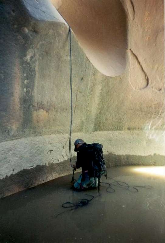 Rapping into a pothole in Cable Canyon.
Getting There
You must have a good map to navigate in this wild region. The road is accessible to passenger cars if care is taken, but go well prepared. Leave with a full tank of gas from Emery or Green River before heading out on the back-roads.There are three possible exits to take off I-70 between Emery and Green River. The easiest driving route to follow may be from Exit 97. Roads from Exits 89 or Exit 105 will also lead you to the same area.
From Exit 97, follow the road south for about 9 miles to a four-way junction. Keep straight and follow the signs/roads to Moroni slopes. There are many junctions, but drive past Hebes Mountain and between the two Cedar Mountains on the map, and then two the Moroni Slopes catchment and Horse Heaven Reservoir. This is the trailhead for the South Fork. To reach the North Fork trailhead, continue down the road a short distance and park at the point marked 6602 on The Frying Pan 7.5 minute map.
 Pothole section of Cable Canyon.
Routes Overview
These are meant to be overviews only, so please see the route pages for more info.There are two possible routes for getting into the main canyon. They are the North Fork and South Fork. The South Fork is the shorter of the two routes
North Fork Route: From the trailhead, route-find west and contour south into the canyon. The route is 4th class, and some may prefer the comfort of a rope, but I would highly recommend that if you find yourself needing a rope, that you try another canyon. If you need a rope here, this is not the trip for you. Continue down the canyon and negtiate several obstacles. Right at the confluence of the two forks is a 24-foot drop into a swimming hole. You could rappel in, but the easiest way around is to retreat 400 feet and climb up a crack on the SW side of the canyon. This crack will lead into the South Fork. Continue down the canyon to the confluence, which is at the mentioned pool.
South Fork Route: From the trailhead (Horse Heaven Reservoir), follow the faint vehicle track along the rim of the South Fork. You must find a route into the canyon. There are several possibilities, and all have some challenge to them. After you find a route into the canyon, follow the canyon down to the confluence with the North Fork and pool mentioned above. There is one major obstacle 2/3 of the way down the South Fork. You can pass the major drop off on the left (north) side. This is a fair challenge, but if you have trouble here, seriously reconsider heading further down canyon.
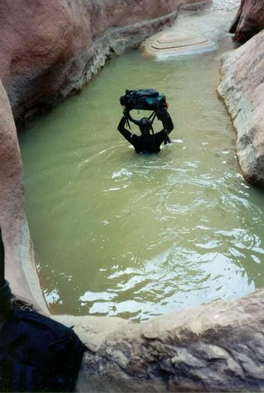
Now that you are at the confluence, from either of the two above routes, you must swim the mentioned pool. Continue down canyon. Sontinue down the canyon, passing many difficult obstacles (see the route description). This canyon requires much skill and climbing ability. There are several swims as well. Exit the canyon and follow the rim of the main canyon and then the South Fork all the way back to Horse Heaven Reservoir.
 Lots of rope work is required.
Clean Canyoneering Ethics
The canyons in this area are very pristine. Bolts are not needed to descend this canyon, and would detract from the incredibly pristine setting of this slot canyon. There were no bolts in the canyon at the time of our descent, but since then, some low-skill climbers have placed some. Please keep it as natural as possible by not placing bolts. There are plenty of chockstones to wrap slings around for anchors. It would be best to use a retrievable sling system, but if you don't have any experience with this, leave a short sling behind at every drop. Try to leave as little behind as possible. This slot is not for beginners; canyoneering techniques must be practiced before going on this trip. Doing the canyon without ropes is not recommended, but please do it without placing hardware.
Equipment Needed
Two 50 meter ropes (and maybe a few short ones), a climbing harness, at least 100 feet of sling, preferably more, 20 descending rings, an aider, a headlamp, a life jacket, and drybags for all gear. Also recommended: A wetsuit in cool weather, and a bolt kit, but please only place a bolt in a real emergency!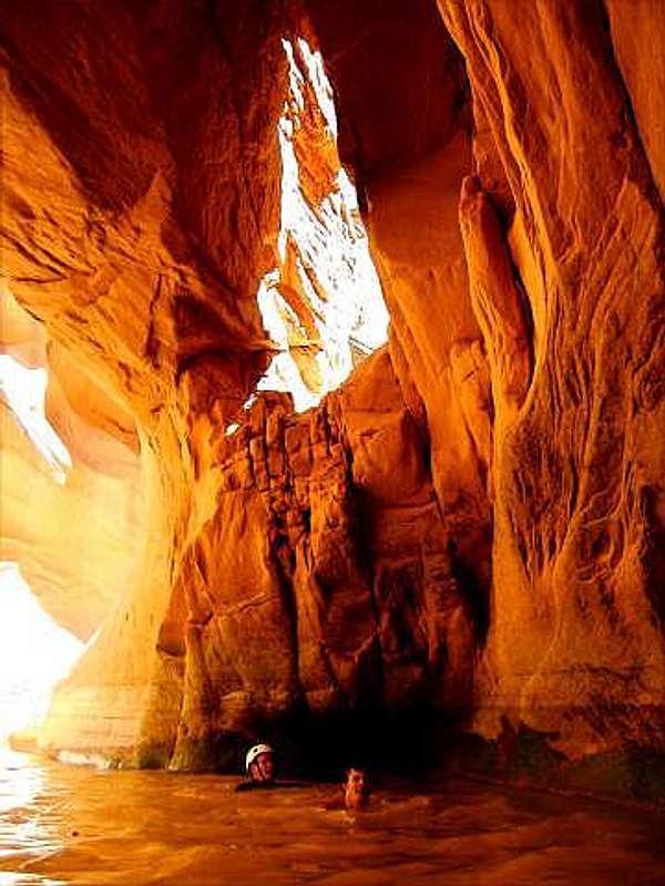 Swimming is required in the slot.
Time Needed
This canyon will take a very long day to negotiate. We took 12.67 hours from the North Fork, but we were moving very quickly. Take a headlamp and be prepared to route-find back in the dark if necessary. You will have to do the canyon as a day trip unless you think you take a pack, which makes the climbing sections near impossible. Many obstacles are here to slow you down.
Red Tape
No permits are required. No red tape, justpotholes you must climb out of.
When To Climb
May and early June is the best time. In April you could probably do the canyon if you had a wetsuit. Summer is searing hot on the hike out through the desert, and in winter swimming through chunks of ice isn't that fun. Fall is nice too temperature wise, but this is such a long day, you would probably run out of daylight long before you got back to your vehicle.Stay out of this canyon with any threats of rain. Flash floods can easily kill you if a thunderstorm is present because there is nowhere to seek high ground in the slot canyon.
 Expect to get wet and the water is cool most of the year.
Camping
There are many informal campsites near and along the road to the trailhead. There isn't an official campground for many, many miles from out here!Mountain Conditions
WEATHER FORECAST FOR SAN RAFAEL SWELLWeather and climate data for the Hanksville is below. *National Weather Service Data 1912-2004.
| MONTH | AVE HIGH | AVE LOW | REC HIGH | REC LOW | AVE PRECIP (in) |
| JAN | 39 | 9 | 69 | -35 | .33 |
| FEB | 49 | 19 | 74 | -33 | .21 |
| MAR | 60 | 27 | 88 | 4 | .42 |
| APR | 70 | 35 | 98 | 10 | .40 |
| MAY | 81 | 44 | 107 | 23 | .46 |
| JUN | 91 | 53 | 110 | 31 | .27 |
| JUL | 97 | 60 | 114 | 38 | .48 |
| AUG | 94 | 57 | 110 | 35 | .80 |
| SEP | 85 | 48 | 105 | 24 | .68 |
| OCT | 72 | 35 | 95 | -6 | .68 |
| NOV | 56 | 22 | 82 | -8 | .42 |
| DEC | 44 | 14 | 70 | -24 | .29 |
External Links
- Climb Utah
Lots of canyoneering ideas in the area.