
|
|
Canyon |
|---|---|
|
|
38.39460°N / 110.2601°W |
|
|
Hiking, Trad Climbing, Scrambling, Canyoneering |
|
|
Spring, Fall |
|
|
Overview
Bluejohn Canyon in located in Southeast Utah in a region known as Robbers Roost. The canyon is named for a semi-notorious old west outlaw that used to hide from the law in this and nearby canyons. John Griffith had one brown eye and one blue eye that earned him his nickname Blue John. In the late 1800’s, alone he launched a boat on the Colorado River from Hite and attempted to float through Glen Canyon to Lees Ferry. He disappeared and no trace of him was ever found. The canyon became world famous after Aron Ralston had his epic descent of the canyon. In 2003, he was forced to amputate his own arm in order to escape and survive. After some earier exploration, we made our first trip (the ancient cultures probably found a way through a long time ago and were probably the first visitors-pictographs in well known Horseshoe Canyon [non-technical] below Bluejohn date back 3000-8000 years ago) of the entire canyon (head to mouth) when I led a trip in the mid 1990’s. We found it to be a great canyon. I also told a famous guidebook author of the canyon, but asked that it not be published. Even so, I guess my reuest when unheeded because I was surprised when it actually showed up at the top of the best adventures ever in a book that published a few years later (which was the same book that Aaron Ralston was using on his now infamous trip). Thus it become popular, but not famous, that is until the “Ralston incident”. Because Bluejohn Canyon has showed up in this and now two other guidebooks, and several websites, plus in countless media reports after Aaron’s epic descent, the place has become world famous. What before saw almost no visitors, now sees at least 100 or possibly several more visitors a year and has become one of the most popular and famous slot canyons in Utah. After some of the ones in Zion National Park, this may be the most popular technical slot canyon in Utah. While the canyon requires technical rock and canyoneering skills to negotiate, non-technical hikers can access some of the best parts of the canyon. The technical sections of the canyon are exciting, but not overly dangerous and rated easier than some of the other canyons in the area.
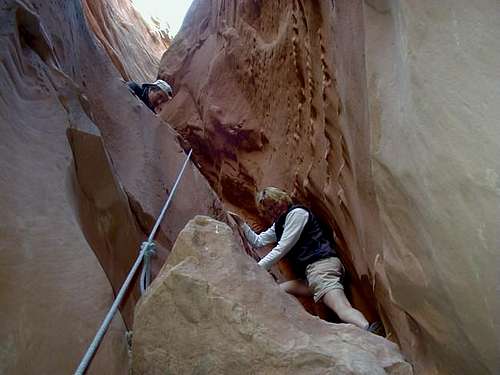
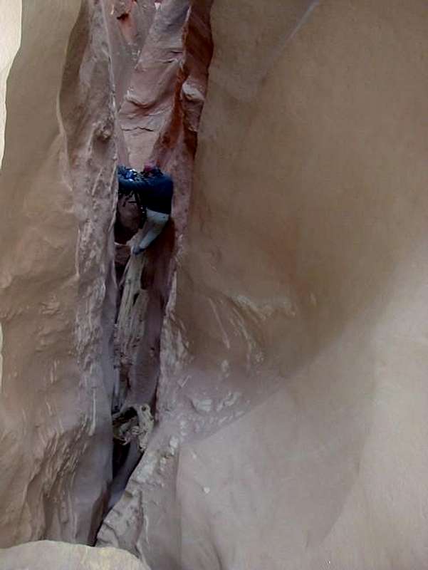
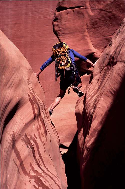 Stemming in Bluejohn Canyon. Fuse photo.
Getting There Warning
Make sure to stock up with plenty of fuel and supplies when headed to the area. The nearest gas stations are in Green River and Hanksville and make sure to have a completely full tank of gas before leaving either town.
Getting There from the North, East, or West and via Hans Flat Road
From I-70 11 miles west of Green River or from I-70 west of Highway 24, take exit 149 on Highway 24 southbound. Follow the highway south to the Hans Flat Road on the east side of the Highway, which is between mile markers 135 and 136. This is just south of the Goblin Valley State Park turnoff (west side of the highway). Pull out the map and have it handy from here on. Follow the main gravel road (several forks are passed; stay on the main one) for 24 miles or so to a major junction (which will be referred to as “Horseshoe Junction” for clarity). Let’s stop here. West Fork Trailhead/West E/E Trailhead This Trailhead access the West Fork of Bluejohn Canyon as well as Little Bluejohn Canyon. Turn right at Horseshoe Junction. Drive the road for about 6.9 miles to a small sandy 4wd track on the left (east). [This is just before a major junction in the main road, so if you hit the major junction, turn around and backtrack for about 0.2 miles]. Either park here or follow the sandy 4wd track for a short distance. “Shortcut” Trailhead This trailhead accesses the Main Fork Blue John Canyon. Turn right at Horseshoe Junction as mentioned above. Follow the road south for 7.1 miles to another signed fork in the road. Turn left towards the Hans Flat Ranger Station. Follow the road for about 0.8 to 1.0 miles or so and not too far after a bend. We parked at a lone cedar tree. There are no other landmarks and the exact place you park isn’t that important. Granary Springs Trailhead This trailhead accesses the Main Fork of Bluejohn Canyon, the Squeeze Fork Bluejohn Canyon, and the East Fork Bluejohn Canyon. Turn right at Horseshoe Junction as mentioned above. Follow the road south for 7.1 miles to another signed fork in the road. Turn left towards the Hans Flat Ranger Station. Follow the road south for 2.6 miles to a small road on the left (east). This short road leads to some old ranch buildings. The dilapidated ranch building is spray painted “Motel 6”. Park here. Horseshoe Canyon Trailhead This trailhead is for the exit route if you do the entire Bluejohn Canyon to Horseshoe Canyon. From Horseshoe Junction as mentioned above turn left (versus right for all the other trailheads). Follow the road for 5.1 miles to another junction. Turn right here on the road posted for “Horseshoe Canyon Foot Trail”. Follow this road for 1.7 miles to a parking lot. Park here.
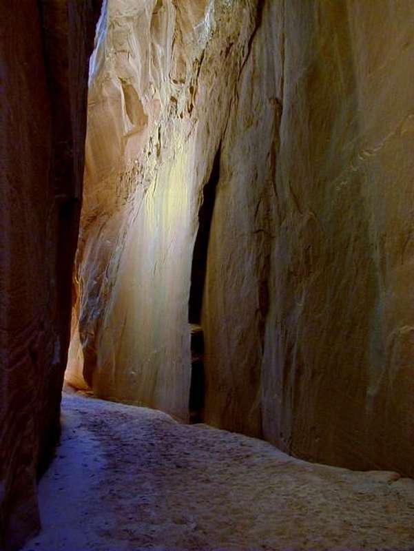
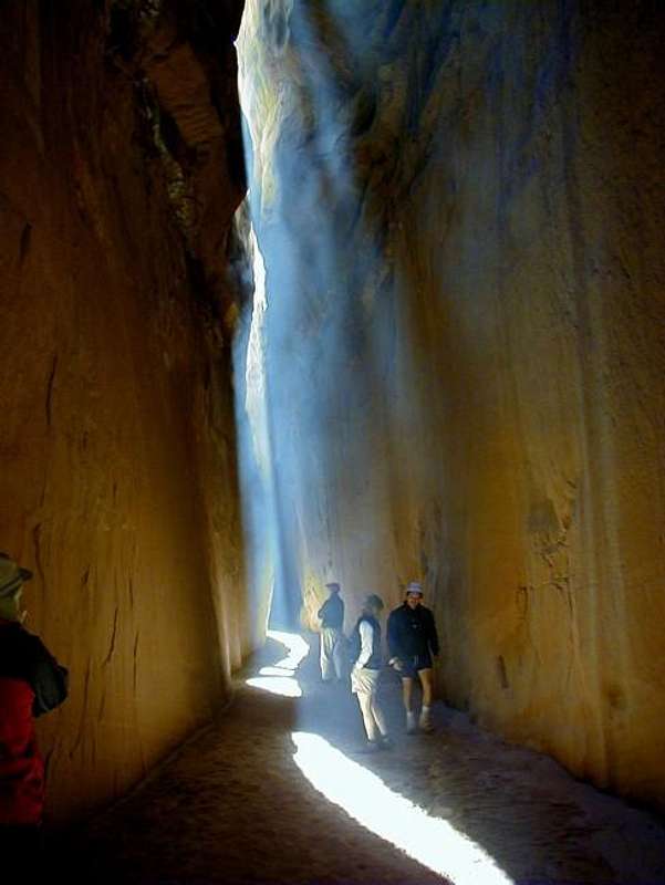 Natural lighting in Bluejohn Canyon. The "smoky effect" is caused by fine dust particles in the air that were disturbed while hiking. Mark McCray took this one and the others on our trip.
Getting There from South via Hans Flat Road
From the junction of Highway 95 and Highway 124 in Hanksville, drive north on Highway 124 for approximately 18 miles to the Hans Flat Road on the east side of the Highway, which is between mile markers 135 and 136. If you reach the Goblin Valley State Park turnoff, you have gone too far and need to backtrack a short distance. From the Hans Flat Road between mile markers 135 and 136, follow the roads to any of the trailheads as described above. From the South, you can also get to the trailheads via Hite and the Maze, but the route is complicated, slow, and rough (4wd always required), though very scenic. Don’t even ask me to describe that route in detail. Buy a map.
Getting There From the North, East, or West and via Green River Road
This route is shorter than the one via the Hans Flat Road, but takes a bit longer because the road is gravel for a much longer distance. From Green River at Center and Main, turn south and follow the road signed for the airport. Stay on the roads signed for the airport until you get to a gravel road on the left with a sign for San Rafael Desert and Horseshoe Canyon. Turn onto this road. This is known as the Green River Road. Follow the Green River Road south (crossing the San Rafael River at just over 19 miles) for about 39-40 miles to the turnoff for Horseshoe Canyon Trailhead (see above). You can either take the road to this trailhead, or continue along the main road for 5.1 miles to Horseshoe junction where all the other trailheads are reached via the routes described above.
Routes Overview
There are many, many forks and routes available. Below is a quick summary of each fork. See the route pages for more details. (Several route pages will be added but are under construction. All the below routes will have route pages in the near future).
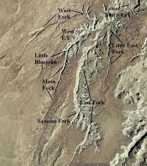 These are the major forks of Bluejohn Canyon. This map is for identification purposes and not to be used for navigation. Google Earth image.
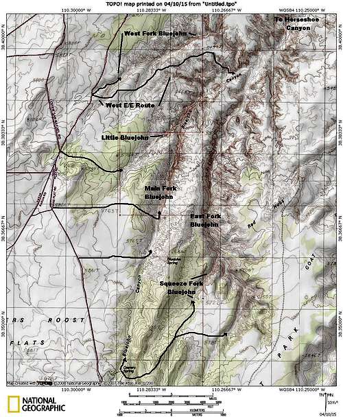 Here is an outline of the various routes.
 Main Fork Bluejohn This fork has a long narrows section including one walk through corridor section. By a competent rock climber, can be done without ropes in both directions, up and down, but all parties should bring a 100 or more foot climbing rope anyway and just in case, regardless of climbing experience. Climbing out is rated 5.7 or 5.8 on the YDS, but isn’t very exposed. After completing the Main Fork from the top you can exit either the West Fork Bluejohn, the West E/E (entry/exit) Route, or continue all the way down through Lower Bluejohn Canyon to Horseshoe Canyon.
 Climbing out the Main Fork Bluejohn.
Little Bluejohn This fork has a short narrows and enters Main Fork Bluejohn Canyon just below the Corridor Narrows. Exit options include going down canyon and using the West E/E Route, or climbing all the way out the Main Fork. You can also continue all the way down canyon through Lower Bluejohn. West E/E Route This is a cross country route of only class 2 in difficulty, but a route that required routefinding. The route can be used to enter or exit the Main Fork Bluejohn Canyon. If you want to see some of the good parts of Bluejohn without any technical difficulty, this is your route.
 West E/E Route to Bluejohn Canyon.
West Fork Bluejohn This fork can be used to enter or exit the Bluejohn complex. The route is around 5.5 or 5.6, but there is a bypass around this section that is supposed to be only 3rd class. The canyon has a short section of narrows. The West Fork may be the best route to access Lower Bluejohn to Horseshoe Canyon since coming down the Main or East Forks makes for a very long day. It is also commonly used as an exit route after completing the Main Fork from the bottom down. Little East Fork Bluejohn This fork is mostly uninteresting so won’t be detailed here. It is the largest east-side side drainage of the East Fork. East Fork Bluejohn The East Fork is yet another interesting Fork of Bluejohn and also the longest fork as well. It has some long interesting narrows and some technical challenges. It requires a 100 foot or longer rope. After completing the East Fork from the top you can exit either the West Fork Bluejohn, the West E/E (entry/exit) Route, or continue all the way down through Lower Bluejohn Canyon to Horseshoe Canyon. Competent rock climbers can exit via the Main Fork and this has become a popular loop. Squeeze Fork (a.k.a. Dark Slot) Bluejohn This is one of the best sections of the Bluejohn system. It is a short fork, but involves some spicy downclimbs and some dark narrows. Competent rock climbers can climb up or down this slot. A 100 foot or longer rope is recommended. Exit options are the same for the East Fork or you can go up the East Fork as well. Lower Bluejohn This is the section of the canyon that has become notorious because of the accident with Aron Ralston and is where he amputated his arm. This is one of the best sections (perhaps the best) of Bluejohn Canyon, but the narrows are fairly short. They are very convoluted and quite scenic and the canyon can be very dark at times. This section of the complex (lower Bluejohn) is accessed through any of the routes above. This is the least popular section of Bluejohn because it involves a long hike out though Horseshoe Canyon. Alternately, any competent rock climber can re-ascend the slot after reaching the big drop. Completing the route through Bluejohn and Horseshoe Canyon requires at least a 50 meter rope. In Horseshoe Canyon, there are several pictograph panels said to be dated to 3000-8000 years old. These are supposed to be the best pictograph panels in the world.
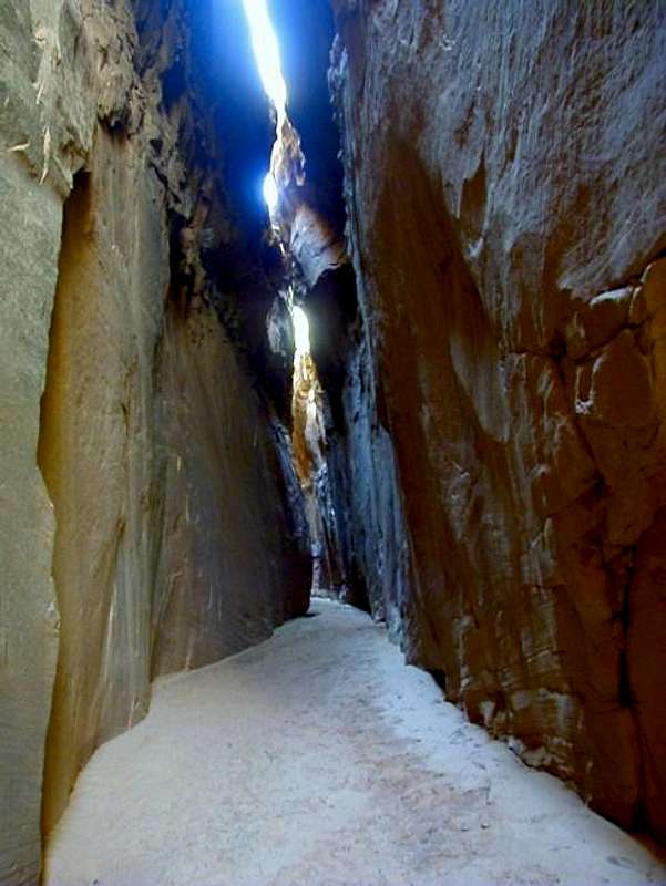 Narrows in Bluejohn Canyon.
Suggested Routes
The best slots are in the East Fork, Main Fork, and Squeeze Fork. Lower Bluejohn actually may have the best slot section, but the slot is short and it's a long hike out so the rewards to effort ratio is lower. The East Fork has the longest slot so by that criteria, it may be the best of all the forks. The below are listed in order of length and time needed. Asterisk indicate what I believe to be the best routes. You can also add Lower Bluejohn to any of the non-marathon routes and upclimb back out. This will add 2-3 hours to any of the below (the Lower Bluejohn is already covered in the marathon routes). Half a Day or Less Down West Fork and exit West E/E or vice versa Down Little Bluejohn and exit West E/E Moderate Day Down Little Bluejohn and exit West Fork Down Main Fork and exit West Fork or West E/E Down Little Bluejohn and out Main Fork. Full Day Down East Fork and exit West Fork or West E/E Down Squeeze Fork and exit West Fork or West E/E Long Day Down East Fork and exit Main Fork Marathon Down West Fork and exit Horseshoe Canyon Down Little Bluejohn and exit Horseshoe Canyon Down Main Fork and exit Horseshoe Canyon Down East Fork and exit Horseshoe Canyon Down Squeeze Fork and exit Horseshoe Canyon
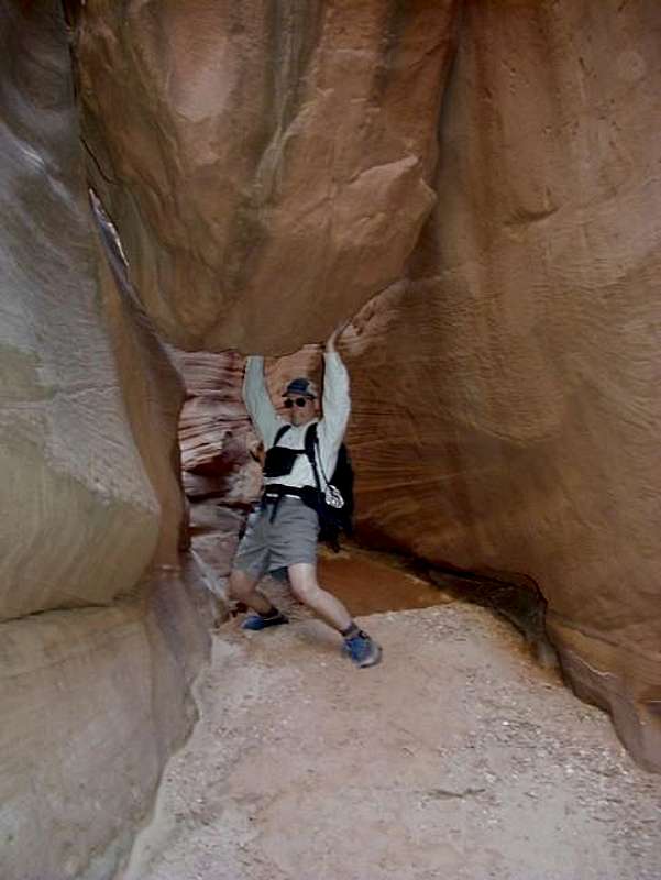
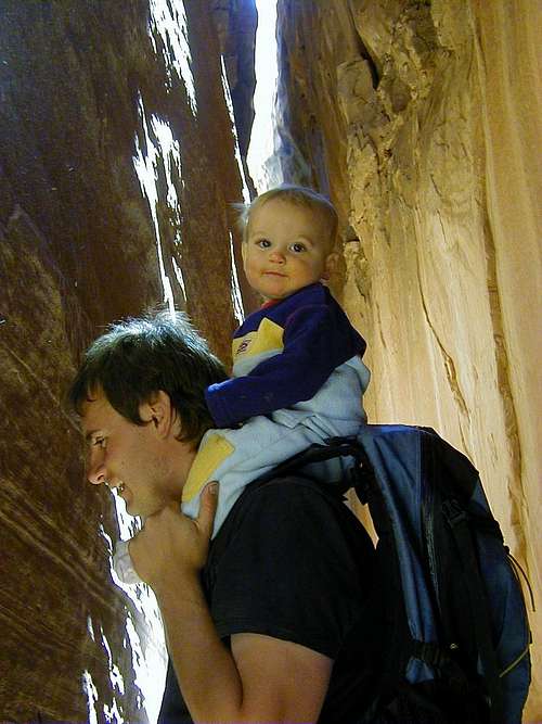 Kessler and me in Bluejohn Canyon, March 2003. One month before Aron Ralston cut is arm off in the canyon, making the place world famous.
 Clean Climbing and Canyoneering Ethics
The canyons in this area are, or at least were very pristine. Bolts are not needed to descend any forks of this canyon, and would detract from the pristine setting of this wild canyon. There are plenty of chockstones to wrap slings around for anchors. Try to leave as little behind as possible. This trip is certainly not for beginners; climbing and canyoneering techniques must be practiced before going on this trip. Other than the “big drop” in Lower Bluejohn, there is really no excuse or reasons to leave behind webbing or other trash either. The forks of the canyon can be done clean and with retrievable anchor systems. There are now at least two bolted anchors in the system; one in the East Fork and one in Lower Bluejohn. Please do not add any more. Only the least competent and most lazy climbers and canyoneers are leaving trash in this system. Don’t be one of them. Other than the big drop all of these routes have been done many, many times without leaving trash behind.
 Bolt ladders and trash are not needed.
Red Tape
This is Utah. Behave yourself. There is no Red tape. In addition to no permits required, there is no private land for miles and miles and miles around in any direction either.
 Hurry up! I can't hold this rock much longer. Mark McCray in Bluejohn Canyon. No red tape here.
Camping
There are fair to good scattered throughout this region. The nearest official campground is many, many miles from this canyon. Granary Spring makes an OK though sometimes grungy campsite with cow pies around. Camping in the canyon requires special preparation because carrying an overnight pack though any of the forks except for the West E/E route is difficult. There is no water suitable for drinking around either.
Seasons
Although you can visit Bluejohn Canyon year round, Summer is extremely hot with temperatures exceeding 100F degrees (38C) and winter temperatures drop well below 0F (-18C). The best times of the year for this adventure are March through May and then again in mid-September through mid-November. There is flash flood potential in the narrow sections, so have a good weather forecast before heading down the canyon. This is a land of weather extremes. Temperatures in the nearest towns have ranged from -42F (-41C) to 112F (44.5C) at Green River and -35F (-37) to 114F (46C) at Hanksville. Sunny weather predominates and it only rains a few times a year, but when it does rain, it can really pour! Don't underestimate flash flood danger. A flash flood in Bluejohn Canyon would kill you if you are in the slot sections.
 Light show in March 2003. Bluejohn Canyon. Photographing such canyons is very challenging. It is difficult to get the right combination of light, shadows, and contrast.
Canyon Conditions
CLICK HERE FOR WEATHER FORECAST FOR BLUEJOHN CANYON Weather and climate data for the Hanksville is below. *National Weather Service Data 1912-2004.
| MONTH | AVE HIGH | AVE LOW | REC HIGH | REC LOW | AVE PRECIP (in) |
| JAN | 39 | 9 | 69 | -35 | 0.33 |
| FEB | 49 | 19 | 74 | -33 | 0.21 |
| MAR | 60 | 27 | 88 | 4 | 0.42 |
| APR | 70 | 35 | 98 | 10 | 0.40 |
| MAY | 81 | 44 | 107 | 23 | 0.46 |
| JUN | 91 | 53 | 110 | 31 | 0.27 |
| JUL | 97 | 60 | 114 | 38 | 0.48 |
| AUG | 94 | 57 | 110 | 35 | 0.80 |
| SEP | 85 | 48 | 105 | 24 | 0.68<TD |
| OCT | 72 | 35 | 95 | -6 | 0.68 |
| NOV | 56 | 22 | 82 | -8 | 0.42 |
| DEC | 44 | 14 | 70 | -24 | 0.29 |
External Links
Several Media Stories on Bluejohn Canyon
Cheating Death in Bluejohn Canyon
For a good write up on Aaron Ralston's epic descent, see climb-utah.com's description of the events: Cheating Death in Bluejohn Canyon