
|
|
Area/Range |
|---|---|
|
|
53.17477°N / 3.99078°W |
|
|
Hiking, Mountaineering, Trad Climbing |
|
|
Spring, Summer, Fall, Winter |
|
|
3000 ft / 914 m |
|
|
Overview
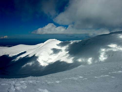
The Carneddau, (Welsh - Carnedd , "Cairn" Carneddau (plural), "Cairns" ) forming a large part of the mountains of Northern Snowdonia (or Eryri in Welsh) are the largest area of high ground in England and Wales comprising some 7 summits over 3000 feet. The range comprises a long mountain ridge with surrounding grass and moorland and a number of beautiful valleys providing excellent hillwalking, rock climbing and (unreliably) in season ice climbing and ski touring. Looking north from Carnedd Lywellyn
 Northern Carneddau - Foel Fras and Foel Grach from Yr Elen
They are bordered by the Irish Sea and the Isle of Anglesey (Ynys Mon) to the north and west, to the south and east are high ground and the other mountainous areas of Snowdonia.
The Carneddau are typically British uplands comprising rolling hills, craggy in some places, soft and rounded in others covered in rock, heather and grassland and are populated with welsh mountain sheep, wild ponies, buzzards and other birds of prey, foxes, rabbits, hares, stoats and adders.
 Locals
 Wild foal
Like all British hills the weather is unreliable and changeable, cloud and rain are frequent and it can snow at any time between about October and May. Take your map and compass as these are easy hills to get lost in - even though they are well frequented and quite near to civilisation. Visibility can go from 50 miles to 6 feet in a matter of minutes and the hills are often quite featureless.
Though walking in these hills is popular and the main routes have good paths it is still possible to find solitude. The Carneddau have a quiet beauty of their own - especially off the beaten track. Spend a night camping high in the hills or start out early in the morning and you will see the Carneddau at their best.
Whilst only a small range on a global scale the Carneddau encapsulate much that is special about mountain regions. The fresh stillness of an early summers morning, the call of the skylark and curlew, the silence of a mountaintop in a mist, the roar of a winter blizzard straight from the north atlantic can all be experienced here.
The hills are known by beautiful Welsh names, the main summits (In height order) are as follows:
 Carnedd Llwellyn
Carnedd Llewellyn 1064m (Llewellyn's Cairn) named after the last King of Wales I belive.
The second highest summit in Wales and much less popular than Snowdon(Yr Wyddfa - The Tomb) which is the highest. A large rounded dome surrounded by lonely valleys and crags, with a small high cwm on the north east side which provides enjoyable, easy winter climbing. It is most often approached along the ridge from the Ogwen Valley, though in my opinion the most enjoyable ascent of Llewellyn is from Gerlan via Yr Elen.
 Carnedd Dafydd Westerly Slopes
 Carnedd Dafydd
Carnedd Dafydd 1040m (Dafydd's Cairn)
From the Ogwen Valley Dafydd is a relatively nondescript mountain with open grassy slopes, however when viewed from the Afon Llafar and from the west generally Dafydd stands out due to its impressive monolithic butresses and crags. Along the ridge from the summit lies the Ysgolion Duon - the Black Ladders, cliffs that are home of serious winter mixed climbs with a Scottish feel. This area can be seen on the second photo above to the left of the summit. I think the most enjoyable way up Dafydd is via the Llech Dhu spur -this is the scrambly arete which is in the shade on the first photo above.
 Pen Yr Ole Wen in winter - enlarge the picture and you can make out a trail of ants on their way up!
Pen yr Ole Wen 978m (Head of the White Light)
This is a somewhat maligned hill because of the eroded paths up it from the Ogwen Valley. It has a nice east facing Cwm which is very peaceful in the summer and contains some enjoyble rock climbs, and in winter it can assume a somewhat alpine appearance as the photo above can show. Most people climb it on the way to Carnedd Dafydd.
Foel Grach 976m (Scabby Hill)
Foel Grach is a rounded indistinct summit with a small refuge about 10 m away from the top behind a mound of rocks. Take care when going towards Carnedd Llywellyn from Foel Grach as the ridge is completely flat and it is very easy to miss the path in the mist.
 Yr Elen
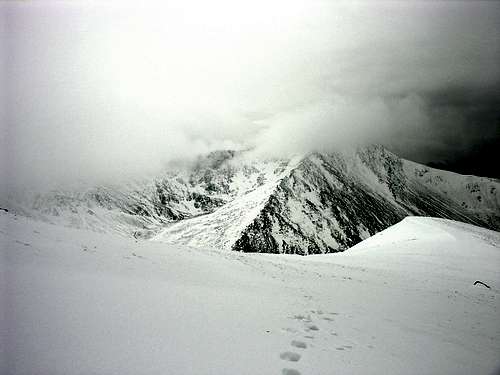 Yr Elen and Cwm Caseg in deteriorating weather
Yr Elen 962m (Helen)
An elegant hill with soft sweeping slopes to the south and west and on the north side a rough coire known as Cwm Caseg with a pleasant lake. It can be climbed from Carnedd Llywellyn along a grassy arete.
Foel Fras 942m (Bare Hill)
Towards the end of the ridge lies Foel Fras. The summit is bisected by a dry stone wall, but it is an enjoyable walk from Aber Falls and is the quietest summit. Wild ponies are often found here in the early morning during the summer enjoying the grass.
Garnedd Uchaf 926m (Highest Hill)
This is the least distinct summit and is often hard to find in mist. It is situated between Foel Fras and Foel Grach on a grassy plateau. The views of Yr Elen are often good.
There are also a large number of equally nice lower hills that don't exceed the rather arbitary 3000 ft (914m) barrier. I will try to cover these in the future.
Access and History
These hills are easily accessed via road and rail links though a walk in of an hour or two is not uncommon. See the Google map for road access. Just a quick ski down to the A5 from the upper slopes of Carnedd Dafydd
The most common access is from the A5 at Ogwen, however the hills can also be reached from the A55 and the Conwy valley - though some of the more obscure routes can be difficult in snowy or icy roads. Be considerate when parking near farms or houses, as parking can be difficult for locals - you may return to find your tires let down or worse!
It is worth trying less obvious access routes - often they are more beautiful, and can lead to untouched and obscure corners of the hills away from the main paths.
 Hut circle
Explore the hills and you may come across Iron Age hut circles, Stone Circles, remains of crashed WWII bombers, old mines and many other signs of mans passing. The Ordanance Survey map of the area is invaluable for those interested in this regard.
Red Tape
None - go when you like just keep to the footpaths on farmland and don't scare the wildlife and keep your dog on a lead near the sheep and horses. Don't take anything away with you apart from photo's and good memories.Much of the land is in the ownership of the National Trust who aim to preserve and maintain for future generations.
If there is an emergency dial 999 and ask for Mountain Rescue - they can assist via land and air, however this service must not be misused or taken for granted. As in all mountains self reliance is the watchword. A mobile phone can be of help but should not be relied upon.
 A ride from the RAF
External Links
The following may help if you want further info:Met Office Mountain Forecast for Snowdonia
Harbach for ever: A good website with suggestions for walks in the area
Walking Britain ; good suggestions for walks with photos
Ordnance Survey - the UK mapping agency, 1:25,000 map views of the area are available with the Get-a-map facility - great for route planning
Hightrek - a local guiding and holiday service who report on mountain conditions
Local air crash sites - it is a testament to the size of these hills that a large proportion of the crashes seem to be in the Carneddau
Comment on archeology of the area
Camping
On high ground above the fridd (field line) camp as you wish - there are many nice lakes and streams to camp by, though the ground can be rather damp in places. Just don't leave any trace of your passing. Don't camp on farmland unless you have permission to do so.There are also a couple of well placed campsites on farms in the Ogwen Valley -please use these and help support the rural economy.
Welsh Language
The Carneddau are situated in north Wales, which is an area with a strong welsh culture. The Welsh language is widely spoken in the towns and villages surrounding the Carneddau, generally the more remote the village the more likely you are to encounter the language, though this is a generalisation and it is fair to say almost all locals to the area have some knowledge. On a visit you will also see the language in use on roadsigns, place names, public documents.Welsh is a Celtic language, closely related to Manx, Cornish and Breton and more distantly Gaelic. The Welsh name for Wales is "Cymru" - pronounced "Cumree", and the welsh langage "Gymraeg". The word "Welsh" is actually derived from a Saxon word "Wealas" meaning foreign.
The Welsh spoken today is directly descended from the language of the sixth century. It is one of the oldest living languages in europe and seems to be in good fettle in these parts - though its existence is threatened to some extent by anglicisation of traditionally Welsh areas. The Welsh language was once spoken in one form or another across much of England and Wales, but the language was marginalised over time as other cultures (eg. Norman, Saxon) colonised.
The language has been influenced by latin - some words will seem familiar -from french for example - "Pont" - Bridge , and "Eglwys" - Chruch. There are also fascinating reference points with the past - for example the Welsh word for English is "Saesneg" - meaning Saxon.
To the untrained eye (and English speaker)Welsh can be difficult. To help you are some useful links:
Welsh Language Board - resources in Welsh and English
Welsh phrases in the local dialect
Hear and speak Welsh - learn a few words
Wild Ponies
 Mother and Child
The Carneddau, particularly in the north are inhabited by groups of wild ponies, I do not know the exact number but each mountain seems to have a few - and they may number 200+ in total. The ponies belong to various farming families who live beneath the mountains, but seem to live wild in the hills all year round. Apparently it is the only place in the UK where truly wild horses live (and form their own social structure) with little or no interference from man. (Ponies on Exmoor and Exmoor being closley managed).
 Wild foal
The ponies are typical welsh hill ponies , short stocky varying in colour with long unkempt manes, because they live wild their condition can sometimes be poor - but despite this they appear to be able to sustain a population themselves with a healthy population of foals. They add an interesting element to a day in the hills in these parts - often a large group can be seen dotting the hillside below the long horizons of the Carneddau. Their ancestry is not clear, but it seems to me likely that they are descendants of the working ponies used by the Welsh for many hundreds of years.
mattcymru - Sep 21, 2018 12:58 pm - Hasn't voted
highLargest area of high ground.... yes, over 3000 feet. but its a very small area. there are much bigger areas in northern england over 2000-2500 feet...