
|
|
Mountain/Rock |
|---|---|
|
|
36.05308°N / 111.77294°W |
|
|
Hiking, Scrambling |
|
|
Spring, Summer, Fall, Winter |
|
|
7061 ft / 2152 m |
|
|
The majority of summits in Grand Canyon National Park are intense scrambles, technical spires, or epic adventures to remote buttes and summits that aren't for the casual dayhiker. Cedar Mountain breaks that mold. Located just a few miles east of the popular Desert View area on the south rim, Cedar Mountain is a prominent cinder cone perched just a few miles from the rim. Sitting at the northern edge of the Navajo Flatlands, this is one summit that doesn't require a massive descent into the canyon to climb (although still a decent descent!), any technical climbing skills or even much in the way of scrambling. Thus, it's a great peak for beginners to peakbagging in the Grand Canyon, or anyone looking for a dayhike off the South Rim. The summit register only averages 2-3 parties per year, so if you're after solitude in one of the busiest parks in the country, you'll have it on Cedar Mountain.
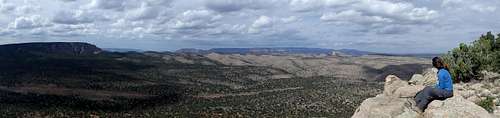
![Summit panorama]()
Summit panorama
Getting There
There are two basic approaches to Cedar Mountain, from the park to the west, or through National Forest to the south:
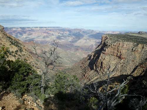
From the Desert View area, hike through the campground, picking up an old road on the backside of campsite #20. This road hits Cedar Mountain Rd. at the junction with the water treatment area. If you decided to drive through the residential area and park off the dirt road directly it will save about 1.5 miles roundtrip. The old road begins to descend to the Navajo Flatlands, and Cedar Mountain is in view ahead from the top of the first switchback. Dropping down the switchbacks offers some of the best views of the hike into the canyon to the north, including glimpses of Escalante Butte and Comanche Point to the north. Beyond this, you'll mostly be in a Juniper and Pinyon Forest. At 3.0 miles from the campground (or 2.25 miles from the dirt pull off), you'll hit a junction. North goes to Point Solitude and is only open to foot traffic. South briefly swings away Cedar Mountain before heading directly to the open prairie at it's base. The open prairie is roughly where one could park with the Gold Hill approach and a sturdy vehicle. Before the Grand Canyon was a park, this was used to graze cattle, and the remains of an old corral can be found at the north end of the prairie.
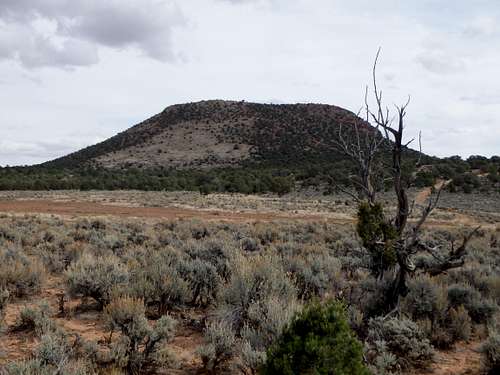
![Prairie below the summit]()
Prairie below the summitAt this point you have two options: either head directly cross-country up the grassy slope, or follow the road a bit further north to the corral before cutting up, avoiding some of the denser brush. Either way, cross country is easy (at least for Arizona) and aside from a few scattered cacti hidden in the grass, the slope is relatively open. The high point of Cedar Mountain is on the northwest point of the plateau with 10' summit cliffs blocking direct access. A low point of the summit rim on the southwest corner of the mountain is probably the easiest option with minimal class II over boulders, and a short walk across the plateau brings you to the summit cairn with register.
![Unnamed Image]()
As with most hiking in Arizona, Fall and Spring are the best. Summer can be brutally hot, although the entire hike is above 6000' with near constant partial shade from Juniper and Pinyon Pine. No water sources. Winter can bring patchy snow and ice, although it is doubtful that it would become deep enough to cause much of an issue on this hike.
There are two developed campgrounds on the South Rim: Mather (which takes reservations) and Desert View. Desert View is obviously the closest, although it is only operational over the summer.
My trip report: The Mountains Are Calling: Cedar Mountain
Summit panorama
Getting There
From the park/ Desert View approach:
Enter Grand Canyon National Park's South Rim either via US 180 to the South or US 89 from Cameron. Make your way to the Desert View area at the far east side of the south rim. From there you can either park in the main Desert View parking lot, or turn down Cedar Mountain Rd, which eventually turns to dirt after passing the ranger residential area. A sign indicates no cars into the residential area, but I believe the dirt road is legally open to traffic. It deteriorates pretty quickly, and I recommend parking in the first turn out available shortly after it turns to dirt.
From the south/ Gold Hill approach:
I have not personally taken this approach so I can not account for road conditions. This comes from "Grand Canyon Summits Select" by Tomasi:
"From Cameron, drive highway 64 until 5 miles past the NF boundary. Just past mile marker 272, turn onto FR 640 for 3 miles. Continue right onto FR 6140 for four miles. At the FR 639 spur, keep right and pass over a cattle guard (5 miles) and eventually descend the steep monocline to the Navajo Flatlands. Continue north, keeping right at the 11.5 mile fork. At 13.5 park for Cedar Mountain."
Route
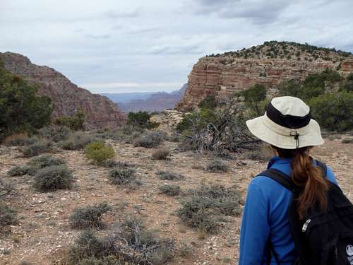
Roundtrip Mileage: 10 (8.5 if you park at the first pull off along Cedar Mountain Rd.)![View north from the switchbacks]()
View north from the switchbacks
View north from the switchbacks
Elevation Gain: 2000' (about 2/3 on the return).
Class II
Prairie below the summit
Red Tape
Admission to GCNP is $30 for 7 days. I highly recommend the "America the Beautiful" Pass for $80, which covers the entrance fees for all federally managed parks and land for one year.
No additional permits are needed unless you're planning on incorporating this into a backcountry trip (dispersed camping is allowed in this area). No entrance fee is required for the Gold Hill approach.
The east side of Cedar Mountain is on Navajo Land and hiking without a permit on Navajo land is not allowed, although the odds of getting caught on this sliver of land next to GCNP are negligble.
When to Climb
Camping
There is plenty of places for camping at large in the National Forest just outside the park.